
GEOGRAPHY
PAPER 1
INSTRUCTIONS TO CANDIDATES
- The paper comprises two sections A and B.
- Attempt all the questions in section A in the spaces provided.
- Answer Questions 6 and any other two questions from Section B using separate answer sheets.
- Candidates should check to ascertain that the question paper has all the questions.
SECTION A
Answer ALL the Questions in this section.
-
- Name two forces that are responsible for the geoid shape of the earth. (2marks)
- Give three reasons why the intensity of solar insolation is higher at the equator than at the poles. (3marks)
- The map below below shows the world’s seismic zones. Use it to answer questions (a)
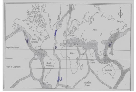
- Name the seismic zones marked U and V (2marks)
U
V - State three natural causes of earthquakes. (3marks)
- Name the seismic zones marked U and V (2marks)
-
- Give two flowage movements of materials. (2marks)
- State three causes of soil creep (3marks)
- The diagram below show a river and its tributaries. Use it to answer the questions (a)

- Name the parts marked L and M (2marks)
L
M - State three factors that influence river deposition. (3marks)
- Name the parts marked L and M (2marks)
-
- Identify two types of desert landscape. (2marks)
- Describe how wind erode the desert surface by deflation. (3marks)
SECTION B
Answer Questions 6 and any other two from this section.
- Study the map of North Tinderet (1:50,000) provided and answer the following questions.
-
- What is the position of the North Eastern corner of the map by Latitude and Longitude. (2marks)
- Calculate the area of North Ainabkoi bounded by Ainabkoi feeder road and Uganda Coast road with municipality boundary. (2marks)
- Name two types of planted vegetation in the area covered by the map. (2marks)
-
- Measure the distance of the power transmission line from the trigonometrical station 103S12 (in the South West) towards the West. Give your answer in meters. (2 marks)
- What is the bearing of Senghalo sawmill site from the waterhole at grid 7417 (2marks)
- Draw a cross section along northing 24 from Eastings 51 to Easting 58 (Use 1cm represent 40m). On it mark and name the following features. (2marks)
- Season swamp (1mark)
- Lessos shops (1mark)
- District boundary (1mark)
- River Kirobi (1mk)
-
- Describe the relief of the area covered by the map. (5mks)
- Explain how drainage has influenced the distribution of settlements in the area covered by the map. (4marks)
-
-
-
- What is Vulcanicity? (2marks)
- Name two dome shaped intrusive volcanic features. (2marks)
-
- Name two volcanic features found in the Riftvalley of Kenya. (2marks)
- Describe how a basic lava dome is formed. (5marks)
- Give three characteristic of a parasitic cone. (3marks)
- Explain three negative effects of volcanic features to human activities. (6marks)
- Supposed you carried out a field study on volcanic rocks near your school:
- Give three reasons why students collected rock samples. (3marks)
- Give two disadvantages of using direct observation method in collecting data during the field study. (2marks)
-
-
-
- Distinguish between Weather and Climate. (2marks)
- Describe a suitable site you would locate a Weather Station in your school. (3marks)
-
- Identify the type of rainfall experienced in the Lake Region of Kenya and describe how that type of rainfall is formed. (4marks)
- State the characteristics of the climatic conditions experienced in the Kenyan Highlands. (4marks)
- Explain how the following factors influence climate.
- Distance from the sea. (2marks)
- Aspect (2marks)
-
- Account for three characteristics of the Equatorial climate. (6marks)
- Give two measures that can be taken to control the effects of climate change.(2marks)
-
-
-
- Name two sources of underground water. (2marks)
- What is a spring? (2marks)
- State three factors which influence the occurrence of springs. (3marks)
-
- State four conditions necessary for the formation of an artesian well. (4marks)
- Explain three ways in which underground water influences human activities. (6marks)
-
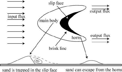
- Apart from a barchan, name two features formed by wind deposition in arid areas. (2marks)
- Using a well labelled diagram, describe how a barchan is formed. (6marks)
-
-
-
- Distinguish between moraine and till. (2marks)
- Name two areas in the world where ice sheets exist today. (2marks)
- The diagram below shows an erosional feature in a glaciated lowland. Use it to answer question (i) and (ii).
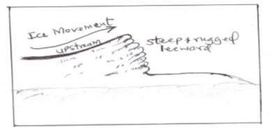
- Identify the features in the diagram. (1mark)
- Describe how the feature shown is formed (3marks)
- Describe how an outwash plain is formed. (4marks)
- Explain three ways in which glaciation influence human environment. (6marks)
- You carried out a field study on glacial erosion on Mt Kenya.
- Give two erosional highland features you identified. (2marks)
- State three challenges you faced during the field study. (3marks)
- Give two reasons why you needed a route map. (2marks)
-
MARKING SCHEME
-
-
- Centrifugal force
- Centripetal force
- Force of gravity
-
- There is higher concentration of heating at the equator than at the poles because the surface area at the equator is small.
- The angle of incidence of the sun's rays at the equator is higher than at the poles hence the variation in intensity.
- At the poles the sun's rays travel over a longer distance that at the equator thus loosing the heat resulting to low intensity.
-
-
-
- U- mid- Atlantic ridge
V- Circum pacific belt
- U- mid- Atlantic ridge
-
- Collision of tectonic plates
- Energy release in the mantle
- Isostatic readjustment
- Violent volcanic erruptions
- Gravitative pressure
- Magma movement within the crust
-
-
-
- Earth flows
- Mud flows
-
- Alternate heating and cooling cause expansion and contraction thue movement of material
- Freezing of soil water lifts the soil particle and as they fall back, they shift position
- Removal of soil downslope/ on the lowest parts trigger movement of soil downslope
- Rain water percolating into the soil drag the soil grains causing downslope
- Ploughing across the slope causes the soil to be turned towards the lower side of the slope
-
-
-
- L- tributary
M - confluence
- L- tributary
-
- Reduction/ reduced gradient / velocity
- Decrease in the volume of water in the stream
- Nature and amount of lead
- Obstacles in the stream channel
- Widening of the stream channel/ river bed
- River entering into a calm water body
- Freezing of river water.
-
-
-
- Sandy desert/ koum/erg
- Stony desert/ serir
- Rocky desert/ hamada
- Badland
-
- The wind pick up dry/loose unconsolidated material such as dust and fine sand particles, and rolls them on grounds and lifting them up in the air.
- Mostly occur where the desert surface is faulted jointed and made up of soft rocks
-
-
-
-
- It is the process through which gaseous / liquid/ molten rock / solid materials are forced into the earth's crust and ejected onto the surface
-
- Batholith
Laccolith
- Batholith
-
-
-
- Hotsprings/ geysers/ steam jets
- calderas/ crater lakes
- volcanic mountain
- lava plateau
- ash and cinder cones
- Plug domes/ spines
- fumaroles/sofaltara
-
- Earth movements occur leading to the formation of a vent in the earths crust
- A volcanic eruption of basic magma occurs through the vent
- At the surface the lava flows in all directions around the vent before cooling and solidifying
- Several/ successive erruptions of basic lava occurs leading to piling up of lava to form layers of lava
- It may have a crater at the top
- Eventually, a large low-lying volcanic dome with broad base forms called a basic lava dome.
-
- Found on th side of a composite cone
- Composed of alternating layers of lava and pyroclasts/ ash
- May have a crater at the top
- Have steep slopes.
-
-
- Flowing lava/ hot ashes and dust/ poisonous gasdes emmitted during volcanic erruptions may cause loss of lives/ destroy property.
- Weather volcanic materials like ashes and granite can result in infertile soils which discourage agriculture
- Some features resulting from volcanicity create barriers, making constructin of communication lines/ houses difficult and expensive eg Yatta Plateau, volcanic mountains
- Rugged nature of some volcanic landscape discourage economic activities such as agriculture and establishment of settlement
- Volcanic mountains create a rain shadow effect on their leeward side which cause aridity and discourage settlement / arable farming
- Dust emmitted during volcanic erruptions interfere with air transport
-
-
- There is no adequate time to carry out lab tests in the field
- Students do not have adequate samples so there is need for expert opinion
- To enable them to build a collection of rock samples/ for future reference
- It would expose more students to their findings through display of their findings
- To create more interest/ motivation and to deepen the understanding of the subject.
-
- It is expensive if one has to travel long distances
- It is tiresome
- It is time consuming
- It is limited to direct sources/ primary sources of data
- It is only suitable to the sighted people
- Some features may be hidden/ out of view
-
-
-
-
- Weather is the short term atmospheric conditions of an area while climate refers to theaverage atmospheric conditions of an area over a long period of time.
-
- The area should be away from buildings/trees/tall objects.
- The ground should be free from flooding.
- The area should have a wide view/open space.
-
- Convectional rainfall.
In this case, this type of rainfall occurs when a large body of water is heated by the sun, resulting in evaporation of water in the lake, as the water vapour rises, it cools through a process known as condensation, which results into formation of a cloud cover. As the clouds get heavier, it results in precipitation. -
- Rainfall throughout the year, ranging from 1000-1500mm
- The main type of rainfall is relief, casued by the South East Trade winds
- The regions also experince relatively moderate humidity
- Average temperature of between 17º - 24ºC, with ana annual temperature range of between 3-5ºC
- Lower slopes are warmer than the higher slopes
- Convectional rainfall.
-
- Large water bodies eg oceans and seas absorb less heat radiation from the sun than continental land masses, therefore on hot days, the sea and adjacent land remains relatively cooler than land masses that are far inland, experiencing the same heat. At night or on cooler days, the continetal land mass looses heat more rapidly than the sea/ocean, hence becomes colder than the sea and surrounding land mass. Therefore, land masses closer to a large water body experience an averagely well conrtolled tempretaure range than land masses that are far inland.
- Aspects affects the rate of solar radiation that the slope of a mountain gets to experience. In the Norther hemispher, southern facing slopes experience more direct sunlight thus tend to be wwarmer and drier. this is also the same for nothern facing slopes of mountains in the southern hemisphere.
- Large water bodies eg oceans and seas absorb less heat radiation from the sun than continental land masses, therefore on hot days, the sea and adjacent land remains relatively cooler than land masses that are far inland, experiencing the same heat. At night or on cooler days, the continetal land mass looses heat more rapidly than the sea/ocean, hence becomes colder than the sea and surrounding land mass. Therefore, land masses closer to a large water body experience an averagely well conrtolled tempretaure range than land masses that are far inland.
-
-
- High rainfall
- High temperatures
- High humidity
-
- Reduced deforrestation/ or increase/maintain forest cover
- Reduction in carbon emissions that cause the green house effect.
-
-
-
-
-
- Springs
- wells
- geysers
- This is a point of emergence of underground water/ subterrainean water to the surface.
-
- Presence of underground water source.
- Pressure in the aquifier
- Size of spring basin
- Amount of rainfall in the region
-
-
-
- Water trapped between two impervious rocks
- The aquifer must outcrop in a region which is a source of water like a rain area beneath a lake to have sufficient water
- The aquifer must dip from a region of water intake and form a broad syncline to exert enough pressure
- The mouth of the well must be lower than the intake area to ansune water comes out of the well on its own
-
- Settlement- They provide sources of water hence encourage development of human settlement
- Economic activities - they enable development of economic activities such as farming and agriculture
- Energy- Some sources such as geysers enable the generation of hydro-electric power hence provide a source of energy, encouraging development of industries and settlements
-
-
-
- Loess
- Drass
- A barchan dune can form when a lot of sand is present in the desert. A steady wind from one direction is needed. The face of a barchan is very steep. As sand escapes over the top of the dune, it forms a trailing wall that is not steep, extending further backward and meeting the desert floor. The trailing wall has a rounded shape from the ends on either side toward the middle, like the form of a crescent moon when it is one quarter full. If there is a substantial change in wind direction, the crescent form can be destroyed.
-
-
-
- Moraine is the material carried by a glacier while till is the material directly deposited by ice when it melt/ upon melting
-
- Antarctica
- Greenland
- Alaska( Northern parts of North America)
-
- Roche Mountonee
- Ice moving across the landscape meets a resistant rock outcrop. The upstream side is smoothened by abrasion forming a smooth gentle slope. The downstream side is eroded by plucking, leading to a steep and rugged leeward slope. This produces a resistant rock which has a smooth upstream and rugged leeward called a roche mountonee.
- Large masses of ice sheets stagnate on a gentle-sloping lowland. As they stagnate, the ice starts melting along the edges / at the terminus/ snowline. The melting ice provide large quantities of water which carry the moraine further beyond the terminus. The heaviest materials are deposited first near the margin while finer materials are carried and deposited further away. Pre-existing depressions and valleys are buried by the fine deposits. The flurio-glacial materials accumulate into very thick layers. This forms an undulating plain of clay, silt and gravel called an outwash plain
(6 ticks max - 4 marks)
- Roche Mountonee
-
- Positive
- Glaciated highlands are beautiful and act as tourist attractions hence a source of foreign exchange.
- Some glacial lakes are natural transport routes, hence lead to develpment of cheap means of transportation
- Waterfalls formed from hanging valleys are ideal sites for hydro-electric power generation plants.
- Boulder vlay plains and outwash plains are fertile hence can be used fro agricultural practices eg The Canadian Prairies
- Many glacial valleys have good pastures in summer , so they provide good pasture in winter while the slopes are good grazing grounds fo spring.
- Sand excavated from the outwash plains, kames and eskers are used for building and construction.
- Fjords have chattered waters suitable for breeding of fish.
- Glacial erosion exposes minerals , hence making it easier for them to be mined and exploited.
- Negative
- Boulder clay deposits create marshy grounds hence discourage agriculture
- Infertile sands on the outwash plains make the land unsuitable for agriculture.
- Glacial erosion may lead to formation of rugged landscapes that make it dificult for the development of infrastructure eg transport and communication or vene settlements.
- Moraine deposits result in formation of numerous lakes thus land for various uses.
- Positive
-
-
- Corrie, Tarn
- Pyramid peaks
- Aretes
- Hanging valleys
- Glacial troughs
- Rock basin
(any 2= 2 marks)
-
- It is tiresome
- It is time consuming to reach every feature
- Some features were obscurred.
- Poor visibility due to foggy conditions
- Some areas were inaccessible due to a rugged terraina and thick forest cover.
- Difficulty in identifying the features
- Biasness
(any 3= 3 mrks)
-
- To find direction
- To follow the appropriate routes
- To locate features
- To enable one to save time
(any 2= 2 marks)
-
-
Join our whatsapp group for latest updates
Tap Here to Download for 50/-
Get on WhatsApp for 50/-
Download Geography Paper 1 Questions and Answers- Kapsabet Pre Mock Exams 2021/2022.
Tap Here to Download for 50/-
Get on WhatsApp for 50/-
Why download?
- ✔ To read offline at any time.
- ✔ To Print at your convenience
- ✔ Share Easily with Friends / Students


