
Instructions to candidates
- This paper consist of two sections; A and B
- Answer all questions in section A
- Answer question 6 and any other two questions from section n B
- All answers must be written in the answer booklet provided
- Candidates should answer the questions in English
- Candidates should check the question paper to ascertain all the pages are printed and that no questions are missing.
Section A
-
- State the uniqueness of Geography as compared to other subjects. (2 marks)
- Give three examples of human environment you know. (3 marks)
- The table below shows rainfall and temperature figures for a given station. Study it and answer question (a)
Months J F M A M J J A S O N D Rainfall (mm) 80 120 340 150 130 90 100 120 320 120 100 80 Temperature(ºC) 28 29 32 31 28 28 29 30 31 30 29 28 - Calculate the annual temperature range for the station (1mark)
- Describe the climate for the station (4marks)
-
- The diagram below shows surface features of karst scenery.
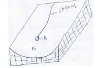
Identify the features marked A and B. (2 marks) - State three conditions necessary for development of karst scenery. (3 marks)
- The diagram below shows surface features of karst scenery.
-
- Define an earthquake. (2 marks)
- State three physical causes of earthquakes. (3 marks)
-
- Distinguish between aridity and desertification. (2 marks)
- State any three solutions to the problem of aridity. (3 marks)
Section B: Answer question 6 and any other two questions in this section.
- Study the map of KIJABE 1:50,000 (Sheet 134/3) provided and answer the following questions.
- Use of marginal information.
- Give the representative fraction scale of the map. (1 marks)
- Identify the vertical interval of the map. (1 mark)
- What type of road is D398. (1 mark)
- What is the six-figure grid reference for Mai Mahiu school. (2marks)
- Measure the distance of the railway line from the level crossing near Kijabe post office to Kijabe station (2marks)
- Describe vegetation of the area covered by the map. (2 marks)
- Draw a rectangle measuring 10 x 6 cm to represent the area bounded by eastings 30 and 40 and northing 94 and 00. (2 mark)
- On it show; Thicket vegetation, railway line and quarry. (3 marks)
- Calculate the new scale of the area you’ve drawn in (b) above. (2 marks)
- With evidence identify three social services offered in the area. (6 marks)
- Name any three artificial drainage features found in the area. (3 marks)
- Use of marginal information.
-
-
- Distinguish between glacial till and fluvio-glacial till. (2 marks)
- Give two reasons why there are no ice sheets in Kenya (2 marks)
- Explain three factors that influence the movement of ice from the place of accumulation. (6 marks)
- Describe how the following glacial erosional features are formed.
- Arete is formed (4 marks)
- Glacial trough (4 marks)
- You carried out a field work on glaciated lowlands.
- Mention two methods of data collection you used. (2 marks)
- Name three glacial depositional features you identified. (3 marks)
- Give two follow up activities that you carried out. (2 marks)
-
-
- Differentiate between folding and faulting (2 marks)
-
- Apart from rift valley, name three features resulting from faulting (2 marks)
- Using well labeled diagrams, describe the formation of the rift valley by tensional forces. (8 marks)
-
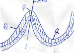
- The diagram below shows a fold. Name the parts marked P, Q and R. (3 marks)
- Name the fold mountains found in; (4 marks)
North west Africa
South America
Western North America
Asia
- The diagram below shows a fold. Name the parts marked P, Q and R. (3 marks)
- State and explain any three effects of fold mountains on the climate of a place. (6 marks)
-
-
- State three wind erosion processes (3 marks)
- Give three factors leading to development of deserts. (3 marks)
- Explain two ways through which wind transports materials in the deserts (4 marks)
- Describe formation of:-
- Wadi (3 marks)
- Seif dune (3 marks)
- Rock pedestal (3 marks)
- Explain three negative effects of desert land forms (6 marks)
-
-
-
- Give three determinants of soil colour (3 marks)
- State four ways in which humus improve the quality of the soil (4 marks)
- Name two types of soil according to structure. (2 marks)
- Explain how the following factors influence formation of soil (4 marks)
- Living organisms
- Topography
- Explain four causes of soil degeneration (4 marks)
- You intend to carry out a field study on soil erosion around your school.
- Give two methods of data recording you will use (2 marks)
- Identify two causes of soil erosion you are likely to come across. (2 marks)
-

MARKING SCHEME
-
- Uniqueness of Geography as a subject
It emphasizes spatial distribution of things on earth’s surface and maps them to show their relationships/patterns. 1×2 = 2mks - Give three examples of human environment you know.
Buildings, trade, bridges, farming, forestry, mining, industry any 3x1= 3 marks
Mark Any other relevant
- Uniqueness of Geography as a subject
-
- Temperature range
32ºC – 28ºC = 4ºC - Describe the climate of the station 1×1 = 1mk
- rainfall is received throughout the year/no real dry month
- highest rainfall received in March 340mm
- the lowest rainfall received in December/January 80mm
- double maximum rainfall regime/two rainy seasons per year
- temperature range is 4ºC
- Temperature range
-
- Identify the features marked A and B.
- sink hole/ swallow hole 1 mark
- dry valley 1 mark
- State three conditions necessary for development of karst scenery.
- The rocks should be hard limestone or chalk
- The rock should be well jointed
- The climate should be hot and humid to accelerate chemical weathering.
Any 3x 1 = 3 marks
- Identify the features marked A and B.
-
- Define earthquake.
Is the sudden and rapid movement of crustal rocks due to seismic waves. 2 marks
*Award 2 mks even if the student has not said ‘due to seismic waves’ - State three physical causes of earthquakes.
- Collision of tectonic plates
- Gravitative force which tend to pull everything towards the centre of the earth
- Volcanicity due to displacement of magma.
- Isostatic adjustment due to disruption of balance between SIMA n SIAL.
Any 3x 1 = 3 mks *They must be statements to score
- Define earthquake.
-
- Distinguish between aridity and desertification.
Aridity is the state of land being deficient in moisture leading to scanty or no vegetation while desertification is the encroachment of arid conditions into productive land. 2 marks
Both must be correct for a student to score - State any three solutions to the problem of aridity.
- Afforestation and reafforestation.
- Irrigating dry land.
- Control industrialization by setting laws to govern pollution.
- Controlled grazing/ keeping manageable herds of animals.
- Planting drought resistant crops.
- Use of alternative fuel sources to avoid relying on wood fuel.
Any 3x 1 = 3 marks
- Distinguish between aridity and desertification.
Section B: Answer question 6 and any other two questions in this section.
-
-
- Give the representative fraction scale of the map. (1 marks)
1:50000 - Identify the vertical interval of the map. (1 mark)
20 metres - What type of road is D398. (1 mark)
Dry weather road - Grid reference 315906 (2 mark)
- Give the representative fraction scale of the map. (1 marks)
- distance 4.3+0.1km
- Describe vegetation of the area covered by the map.
- There area has a thicket to the south
- Forests exist to the east.
- Scrubs are there to the west
- Woodland vegetation exist between Kijabe and Magina
- Bamboo vegetation are found to the north of the forest. 5x1 = 5 marks
-
- Reduction
title 1mk
rectangle 1 mk
features 3 marks
total 5 marks - Calculate the new scale of the area you’ve drawn in (b) above.
2*50000 = 1: 100 000 2 mark
- Reduction
- Social services
- Education services – schools
- Medical /health services – dispensary
- Veterinary services – cattle dip.
- Religious service – Churches
- Welfare services – welfare centre
- Communication service – post office/telephone line
Give any other relevant service 3x2= 6 mks
- Three artificial drainage features found in the area.
- Borehole
- Water trough
- Water tank
- Pump house
-
-
-
- distinguish Glacial Till and fluvio-glacial till
Glacial till is the moraine directly deposited by ice on melting in a stratified manner while fluvio- glacial till is moraine that is deposited by water from melting ice in a stratified manner. 1 ×2=2mks - Reasons why there are no ice sheets in Kenya
- Kenya experience high temperature under which ice-sheets cannot form
- Most parts of Kenya have low attitudes where ice cannot form
- Kenya is found at low latitude /tropics
2 ×1=2mks
- distinguish Glacial Till and fluvio-glacial till
- Explain three factors that influence the movement of ice from the place of accumulation
- Gradient of the land – Ice moves faster when the slope is steep
- Temperature result into travelling leading to faster movement of ice
- Nature of the surface – When the surface on which ice is moving is rough, it causes friction lowering the speed of movement of ice.
- Thickness of glacier – Large masses of ice exerts pressure which leads to melting of ice underneath. This increases the speed of ice movement.
-
- Formation of an arête
- Two adjacent cracks exist on a mountain side
- Two hollows cracks are filled with ice
- The ice erodes the sides through picking & deepens the hollow by abrasion
- Eventually the hollows cirques are separated by a knife edged ridge called an arête.
4 ×1=4mks
N/B: Sequence must be followed
- glacial trough
- a preexisting river valley is filled with ice/ glavier
- as ice moves, tributary glaciers increase the amount of ice in the main valley.
- Glacier erodes V shaped valley by plucking and abrasion.
- Interlocking spurs are trimmed into truncated spurs.
- The glacier deepens, widens and straightens the valley floor forming a u shaped glacial trough.
4 ×1=4mks
N/B: Sequence must be followed
- Formation of an arête
-
- Methods of data collection
- Administering questionnaires
- Interviews/ asking questions
- Observation
- Taking photographs
- Content analysis
- Sampling (2x1= 2 marks)
- depositional features (3 marks)
- outwash plains
- boulder trains
- till
- erratics
- kames and eskes
- terminal moraine
- drumlins
- followup activities(2 marks)
- reading more on the topic
- displaying photographs
- writing reports
- accessing the information against hypothesis.
- Discussion/ comparing notes
- calculating measures of central tendencies
- drawing graphs/ charts
(any two 2x1 2mks)
- Methods of data collection
-
-
- Differentiate between folding and faulting
Faulting is the fracturing / cracking of crustal rocks due to tectonic forces while faulting is the bonding of crustal rocks due to compressional forces.
1 ×2=2mks -
-
- Fault blocks/Tilt blocks
- Fault scarps/escarpments
- Fault steps
- Block mountains/horst blocks
First 3×1=3mks
-
- Rock layers are subjected to tensional forces
- Continued tensional forces result to development of adjacent parallel normal faults in the rocks
- Increased tensional forces cause side blocks to more apart, and the middle block sinks to form the floor of the rift valley
- Steep faulting may occur on the sides.
4×1=4mks – Explanation
3×1 = 3mks – Diagrams
-
-
- P- crest
Q- limb
R- Trough -
- North west Africa - -Atlas
- South America - Andes
- Western North America -Rockies
- Asia - Himalayas
- P- crest
- State and explain any three effects of fold mountains on the climate of a place. (6 marks)
- Windward side of fold mountains receive heavy rainfall
- Leeward side are dry and cool
- Mountaineous areas have low temperatures/ are cooler
- Mountain areas have low pressure
Must be well explained
- Differentiate between folding and faulting
-
-
- State three wind erosion process
- Abrasion
- Deflation
- Attrition
- Give three factors leading to development of deserts
- Excessive overgrazing by large herds of cattle.
- Indiscriminate cutting of trees / deforestation.
- Poor farming methods such ploughing down the slope / mono cropping
- Industralisation
- Continentality
- Cold ocean currents.
- Raid shadow effect. 3x1=3mks
- State three wind erosion process
- Explain two ways through which wind transports materials in the deserts.
- Suspension where fine dust is transported by wind as suspension in the air reducing of the area they pass.
- Traction where fairly heavy particles which cannot be lifted are rolled on the land surface as the wind blows across the land.
- Saltation whereby the materials are transported in the deserts through a series of hops jumps where the materials are fairly heavier and cannot be air borne.
2x2=4mks
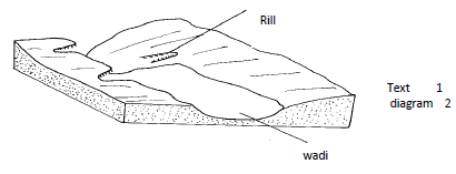
- Describe formation.
- Wadis.
- Flashfloods in deserts cut out rills on steep sided undulating landscape
- The rills are enlarged to form gullies which are further joined by other minor
- Gullies forming wide- steep sided valley called wadi.
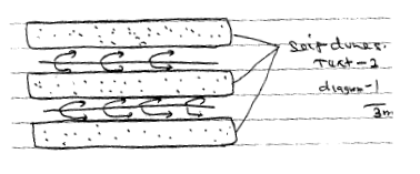
- Seif dunes
- Forms where strong winds interrupts prevailing wind.
- The cross winds breaks crescent shaped barchans forming longitudinal steep sided ridges known as seif dunes
- Rock 7edestal
- Forms through the process of wing abrasion which arodes / attacks alternating layers of hard and soft rocks
- The softer rocks are aroded faster while harder rocks are eroded least forming rock outcrop of different shapes called rock pedestal.
- Wadis.
- Explain three negative effect of deserts landforms
- Sandunes can cover roads making transportation difficult
- Desert landscape makes construction of transport network difficult due to presence of mesa, Wadis yardang etc.
- Sandstorms can burry people and destroy properties.
3x2 =3mks
-
-
-
- Determinants of soil colour
- Chemical rock
- Chemical composition
- Organic matter present
- Drainage of the area.
- Ways in which humus improves the quality of soil (4 marks)
- Determine the soil pH
- Provide habitat for bacteria that assist in aeration
- Determine the soil colour
- Provides food and minerals to plants
- Water retention
- Development of soil structure
- Contribute to further weathering of rock
- Types of soils according to structure
- Granular /crumb
- Platy
- Prismatic
- Columnar/blocks
Living organisms - Breakdown animals & plant venous to form humus
- Help in soil creation
- Help in mixing of soil nutrients.
2×1 =2mks
Topography - Maximum soil formation process occurs on gentle slopes due to reduced soil erosion on step fool to reach maturity due to increase surface erosion.
Causes of soil degeneration - Poor land use practices such as overgrazing and poor cultivation practices
- Drought
- Heavy rainfall that may cause leaching / soil erosion
- Deforestation
4×1 = 4mks- Labeling photographs
- Labeling samples
- Filling tables
- Filling questionnaires
- Tape recording
2×1 = 2mks
- Deforestation
Poor cultivation practices
2×1 =2mks
- Labeling photographs
- Determinants of soil colour
-
Join our whatsapp group for latest updates
Tap Here to Download for 50/-
Get on WhatsApp for 50/-
Download Geography Paper 1 Questions and Answers - Samia Joint Mock Examination 2021/2022.
Tap Here to Download for 50/-
Get on WhatsApp for 50/-
Why download?
- ✔ To read offline at any time.
- ✔ To Print at your convenience
- ✔ Share Easily with Friends / Students


