
- Definition
- Constituents/Composition of Soil
- Soil Water
- Soil Air
- Soil Formation
- Soil Profile
- Soil Catena
- Soil Degeneration
- Soil Erosion
- Management and Conservation of Soil
- Significance of Soils
- Soil Classification

Definition
- Uppermost layer of the earth’s crust on which plants grow.
Constituents/Composition of Soil
- Inorganic Matter
- Weathered rock fragments made of minerals from parent rock.
- Forms skeleton or fabric of soil.
- Forms 45% of total volume.
- Organic Matter
- Decomposed remains of animals and their wastes.
- Forms 5% of total volume.
Significance of Organic Matter - Broken down by bacteria forming humus improving the soil fertility.
- Soil with high organic matter is alkaline while one with low organic matter is acidic.
Soil Water
- Water contained in the soil.
- Forms 25% of total volume.
Types of Soil Water
Hygroscopic Water
- Water held as a thin film around soil particles.
Gravitation Water
- Excess water which moves downwards to the zone of ground water.
Importance - Solvent of minerals and nutrients essential for plant growth.
- Causes leaching carrying of minerals.
- Causes water logging which blocks air circulation causing soil to lack oxygen and become acidic.
Soil Air
- Air contained within air/pore spaces of soil.
- Forms 25% of total volume.
Importance
- For plant and soil organisms metabolism.
- For oxidation which causes conversion of part of organic material into nitrogen.
- For respiration of aerobic micro-organisms which break down organic matter to form humus e.g. bacteria.
Soil Formation
Factors Influencing Soil Forming Processes
- Parent Material
- Determines the type of soil, mineral composition and texture e.g. granite and sandstone weather to form sandy soils rich in quartz, volcanic lavas form clay soils with low quartz content and plants decompose to form loam rich in humus.
- Climate
- Affect rate and type of weathering e.g. heavy rainfall results into deep soils due to heavy weathering and leaching.
- Wind in deserts causes formation of loess soils.
- Living Organisms
- Micro-organisms such as bacteria cause plant and animal remains to decay into humus.
- Burrowing animals and worms mix organic remains with mineral soil component.
- Roots penetrate and add more porosity, improve soil depth and aeration.
- Topography
- There is maximum soil development in rolling and well drained uplands where the rate of erosion matches that of soil erosion.
- Steep slopes result in shallow immature soils due to severe erosion.
- Time
- The longer the time taken by soil forming processes the deeper and well developed soil is.
Soil Forming Processes
- Weathering
- Breakdown of parent rock to form rock particles called regolith.
- Decomposition of Organic Matter
Processes- Mineralization
- Biological and chemical breakdown of dead plant tissues by soil micro-organisms to simple soluble organic substances.
- Humification
- Regrouping of mineralised dead plant material into large molecules to form humus.
- Mineralization
- Leaching
- Carrying of minerals from top layer down to the middle layer.
Types- Ferralisation/lateralisation
- Moving in solution or in suspension of weathered material from horizon “A” to “B.”
- Red soil form in horizon A as ferrisols/laterites (murrum). - Illuviation
- Accumulation/redeposition of materials which had been leached to horizon B.
- Hard soil mass (hard pan) results. - Eluviation
- Mechanical washing down of fine mineral particles in suspension from upper layer to lower layers by water which is percolating downwards. e.g. clay - Podzolisation
- Heavy depletion of horizon A of all minerals especially bases and iron by soluble organic substances.
- Forms ash like soils which are acidic. - Calcification
- Limited leaching which allows redeposition of calcium compounds within the same soil profile. - Ribification
- Dehydration of soils during dry season and leaching during the rainy season.
- Ferralisation/lateralisation
- Carrying of minerals from top layer down to the middle layer.
Properties and Characteristics of Soil
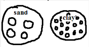
- Texture
- Composition of soil in terms of its particles.
SOIL CLASS
PARTICLE DIAMETER
Coarse sand
0.2 - 2mm
Fine sand
0.2 - 0.02mm
Silt
0.02 - 0.002mm
Clay
Below 0.002mm
- Can be coarse/gritty (sand), medium (loam) or fine (clay).
Importance - Determines soil water retention by that coarse grained soils have poor retention while those fine grained have high water retention.
- Influences ease of root penetration into the soil whereby it is easy on coarse textured and difficult in fine textured.
- Determining soil fertility in that clay content prevents humus from being washed down the soil by water.
- Composition of soil in terms of its particles.
- Structure
- Arrangement of soil particles into aggregate compound particles.
Types - Crump soil structure - soil made of small, soft, groups of particles of irregular shape.
- Granular structure - soil made of porous groups of particles of irregular shape called granules.
- Plate structure - soil made of plate like flat particles arranged in horizontal manner.
- Prismatic structure - soil made of vertical prism like particles with rounded tops.
- Blocky structure - soil made of irregular pieces of soil with sharp corners and edges.
- Arrangement of soil particles into aggregate compound particles.
- Soil PH
- Basicity or acidity measure of a soil.
- Sulphate/phosphate - acidity
- Calcium/magnesium - Basicity
PH VALUE
REACTION DESCRIPTION
8
Alkaline
7
Neutral
6
Slightly acidic
5
Moderately acidic
4
strongly acidic
Importance - Influences the activity of soil micro-organisms and hence decomposition of organic matter.
- Influences rate at which roots absorb minerals.
- Determines the types of crops to be grown e.g. tea-acidic.
- Determines availability of different nutrients to the plants e.g. phosphorous is not available at low PH while potassium and iron not available at high PH.
- Soil Colour
- Visible quality of soil.
-Dark brown or black – considerable amount of organic matter.
-Grey - poorly drained or water logged.
-Whitish- lacks organic matter, iron oxides and has soluble salts concentration.
Importance - Influences soil temperature in that light coloured soils have low temperature and hence low organism activity.
- High temp destroy humus, increase organism activity and provide warmth required for germination.
- Visible quality of soil.
- Soil Porosity
- Amount of pore spaces in a soil sample.
Importance - Influence soil water retention. Clay has high retention and is water logged because it doesn’t allow drainage due to many tiny pore spaces while sand has poor water retention due to rapid percolation caused by large pore spaces.
- Amount of pore spaces in a soil sample.
- Soil Permeability
- Ability to allow the water to pass through.
- Depends on texture and porosity. Clay is impermeable due to being fine textured and tiny pored while sand is permeable due to being coarse textured and very porous.
Soil Profile

- Vertical arrangement of different soil layers from the surface to the bed rock.
- A mature soil is one with a fully developed profile while a young soil is one with a not fully developed profile.
Superficial layer
- Dry decaying organic matter covering the soil surface.
Horizon ‘A’
- Lies under a mat of surface vegetation and raw humus.
- Darker due to high humus content.
- Contains most of plant nutrients.
- Where most plant roots are found.
- Contains active micro organisms which breakdown organic matter into humus.
Horizon ‘B’
- Lies below top soil.
- Has small spaces between particles and hence less aerated.
- Has a hardpan or layer impeding drainage.
- Where most materials washed from horizon A have accumulated.
Horizon ‘C’
- Lies below sub soil.
- Made of partly mechanically weathered rock.
- Product of bed rock or may have been transported.
Horizon ‘D’
- Solid underlying rock.
- May have ponds of water which can be used by deep rooted plants during dry season.
Importance of Soil Profile
- Determines the crops to be planted i.e. mature soils favour deep rooted crops while young soils favour shallow rooted crops.
- Bed rock determines the chemical properties of the soil such as PH and nutrients.
Soil Catena
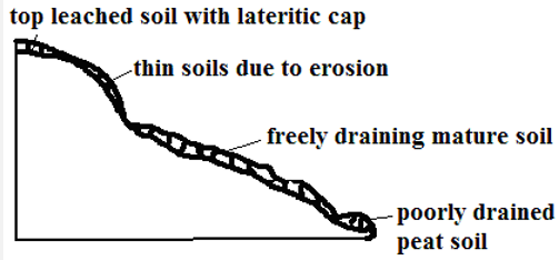
- Arrangement of soil on a mountain slope from top to bottom.
Factors Influencing Development of a Soil Catena
- Relief
- On steep slopes there is high rate of erosion resulting in thin soils while on gentle slopes rate of weathering and erosion is balanced resulting in thick soils.
- On flat areas such as valley floors where there is deposition there are peat or alluvial soils.
- Drainage
- First drainage at mountain tops results in thin stony immature soils.
- Poor drainage in flat areas results in peat or alluvial soils.
- Transportation of Debris
- Surface runoff transports sediments to lower gentle slopes where it accumulates forming deep colluvial soils while thin stony immature soils with little organic matter called xeromorphic soils are left on steep slopes.
Soil Degeneration
- Decline in the usefulness of a soil.
Types
- Physical Degeneration
- Decline in usefulness of a soil in which texture, structure, moisture and quality of soil are affected.
Causes- Deforestation which leads to removal of vegetation which forms a protective cover of the soil exposing it to erosion agents.
- Overgrazing which causes excessive loss of water from the soil causing it to become loose and fine grained and easily eroded.
- Poor Cultivation Techniques
- Pulling hoe along the surface when removing weeds which loosens the soil and when it rains it’s washed away.
- Ploughing of land down slope which accelerates soil erosion.
- Cultivation of steep slopes and along river banks which encourages soil erosion.
- Burning which destroys vegetation covering the soil exposing it to erosion agents.
- Growing crops on the same piece of land from season to season which sucks nutrients from the soil making it fine, loose and easy to be eroded.
- Planting crops such as maize whose foliage doesn’t provide adequate soil cover encourages soil erosion.
- Cultivation in areas that suffer prolonged droughts which loosen the soil causing it to be exposed to erosion during dry seasons.
- Heavy rain resulting to excessive soil erosion and thus poorly aerated.
- Drought which deprives the soil of moisture which holds the soil together causing particles to loosen making it to be easily brown by wind.
- Excavation works such as quarrying, open-cast mining, building of estates and road construction which loosen and expose the soil to erosion agents.
- Soil erosion which robs the soil of top fertile layer.
- Decline in usefulness of a soil in which texture, structure, moisture and quality of soil are affected.
- Chemical Degeneration
- Decline in usefulness due to changes in mineral nutrients of the soil.
Causes- Leaching which makes minerals inaccessible to shallow rooted crops.
- Excessive application of fertilizers which interferes with bacterial activity and causes the soil to become too acidic and unable to support a variety of crops.
- Excess water causing water logging causing acidic conditions.
- Planting one type of crop repeatedly which makes the soil deficient of some nutrients.
- Excessive drought which causes accumulation of salts in the top soil.
- Burning such as in slash and burning which kills micro-organisms causing nitrogen deficiency when nitrogen fixing bacteria is killed.
- Decline in usefulness due to changes in mineral nutrients of the soil.
- Biological Degeneration
- Degeneration due to decline of organic content of the soil and organic matter.
Causes - Deforestation which deprives the soil of its organic content and moisture making it loose and more vulnerable to erosion.
- Burning such as in slash and burning which kills micro-organisms causing low decomposition rate which robs soil of organic matter.
- Overgrazing which causes removal of vegetation causing excessive loss of water from the soil and hence reduced micro-organism activity resulting into shortage of humus.
- Drought and excessive moisture which may lead to a shortage of essential organisms such as bacteria, earthworms, termites and burrowing animals.
- Degeneration due to decline of organic content of the soil and organic matter.
Soil Erosion
- Removal of top soil.
- Agents of soil erosion are water, glacier and wind.
- Causes of soil erosion are human activities and geomorphic processes such as earthquakes and faulting which cause landslides and soil creep.
Conditions Favouring Soil Erosion
- Slope
- Steep slopes accelerate soil erosion while gentle slopes experience less erosion.
- Places with rugged terrain experience gulley erosion.
- Hilly and Steep areas experience rill and gulley erosion.
- Soil Texture
- Areas with fine textured soils such as volcanic ash are more vulnerable to erosion e.g. Nyambene Hills around Karama and Muthara.
- Climate
- Erratic and heavy rains cause splash, rill and sheet erosion.
- Intense heating by the sun causes loosening of soil particles.
- Low rainfall and high temperature leads to scanty or no vegetation which forms protective cover on the soil.
Types of Soil Erosion
- Splash Erosion
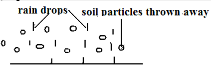
- Removal of soil by rain drops scattering loose particles and carrying them down slope by runoff.
- Rill Erosion

- Removal of top soil by rain water through small channels.
- Occurs when rate of runoff exceeds infiltration and rain water flows over the surface forming small channels called rills.
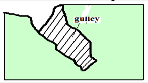
- Gulley Erosion
- Removal of soil through wide and deep channels.
- Occur when moving water or glacier widen and deepen the existing rills.
- Sheet Erosion
- Removal of top soil inform of a thin sheet.
- Common around L.Baringo and Marigat.
Impact/effect of Soil Erosion
Positive
- Creation of rich agricultural lands when eroded soil is carried and deposited e.g. loess and alluvial soils in lower courses of R.Tana.
- Sand eroded from steep slopes and deposited on river bed is scooped for construction purposes e.g. Machakos.
Negative
- Lowers the agricultural productivity of land when fertile top soil is eroded.
- Contributes to desertification when top soil is eroded leaving bare ground destroying vegetation.
- Causes water pollution when agro-chemicals and other chemicals are carried to rivers, lakes or oceans.
- Contributes to flooding by blocking river channels causing them to burst their banks during the rainy season flooding the adjacent areas.
- Causes siltation of water reservoirs reducing their utility e.g. For H.E.P. generation.
- May cause collapsing of structures such as buildings and bridges when soil around them is eroded weakening their foundation.
Management and Conservation of Soil
- Soil management is controlling processes and activities that would cause soil deterioration while soil conservation is protecting soil from destruction.
Soil Management and Conservation Measures
- Crop Rotation
- Growing crops which require different nutrients on the same piece of land on rotational basis to prevents exhaustion of particular mineral nutrients from the soil e.g. leguminous plants to improve nitrogen content of the soil.
- Mixed Farming
- Growing crops and keeping animals on the same farm.
- Manure from animals is used to enrich the soil with minerals and improve its structure.
- Contour Ploughing
- Ploughing across the slope rather than down the slope.
- Helps to trap water on horizontal furrows thus preventing excessive soil removal.
- Terracing
- Dividing the slope into a series of wide steps and crops are grown on them.
- Trap the soil from being carried away by running water and also traps water allowing it to gradually infiltrate into the soil.
- Afforestation and Reafforestation
- Leaves reduce the force of rain drops preventing soil particles from being removed.
- Vegetation increases the rate of infiltration of rain water into the soil thus reducing runoff.
- Roots bind the soil particles together.
- Decayed vegetation provides humus which binds the soil particles together.
- Planting Wind Breakers
- Planting hedges or trees around plots in large fields.
- Act as wind breakers and also trap soil being carried by water.
- Regulating Livestock Numbers
- Matching the number of animals kept to the carrying capacity of land.
- Overgrazing can also be prevented by paddocking which ensures there is always pasture for animals and no area is overgrazed.
- The pasture is subdivided into portions by fencing.
- Animals are left to graze in one paddock at a time.
- Then they are transferred to the next after a few days.
- Constructing Gabions
- Construction of wire mesh boxes which are filled with soil.
- Allow water to pass through but trap the soil then vegetation gradually grows on the trapped soil.
- Planting Cover Crops
- Planting crops which cover the soil properly and holds the soil in place e.g. sweet potato vines.
- Mulching
- Covering the soil with crop residues.
- Reduces the impact of rain drops on the soil.
- Decays enriching soil with nutrients.
- Reduce the rate of moisture evaporation from the soil.
Significance of Soils
- Gives physical support for the rooting system of plants and protects root system from damage.
- Habitat for burrowing animals and bacteria necessary for breakdown of organic matter into humus.
- Medium through which nutrients and air are made available to plants.
- Provides mineral elements to plants e.g. nitrogen, calcium, phosphates, etc.
- Is used in building and construction e.g. clay for making bricks and tiles.
- Clay soil is used in ceramics such as making pots.
- Some soils are used for decorative purpose e.g. ache used among Maasai.
- Source of minerals especially to expectant mothers.
- Soil contains valuable mineral elements such as alluvial gold.
- Soil supports plant life which is a source of food for people and animals especially herbivores.
- Soils are used for medicinal purposes e.g. clay is mixed with some herbs for medical purpose in some communities.
Significance of Soil on Plant Growth
- Characteristics and properties of a particular soil influences plant growth and distribution.
PH
- High PH values favours growth of particular crops e.g. tea requires fairly acidic soils.
Drainage
- Water logged soils allow growth of particular plants like papyrus, tree swamps and mangrove on poorly drained saline soils.
Depth
- Deep soils support deep rooted plants e.g. large trees while shallow soils favour shallow rooted plants with spreading root system e.g. grasses.
Moisture content
- Soils deficient of moisture support drought resistant plants.
Temperature
- There are stunted plants on cold soils and heath and moors on upper levels of mountains.
Aeration
- Poor aeration retards the growth of plants and impairs the roots ability to absorb water and nutrients.
Mineral composition
- Mineral deficiency in the soil causes retardation.
Soil Classification
- Grouping of soil according to specific properties such as age, texture, colour and climate.
- Zonal Order
- Mature soils with a well developed profile due to having undergone long time soil formation processes under good drainage conditions.
Sub-orders- Podsols
- Infertile and acidic soils which are heavily leached with base compounds like calcium removed leaving aluminium and iron compounds
- Found in forested areas and higher latitudes e.g. Scandinavian countries and Canadian Shield.
- Podzolic Soils
- Soils similar with Podsols but found in areas with deciduous forests and hot climates e.g. Congo Basin and Kenya highlands.
- Tundra Soils
- Soils with excessive moisture due to low evaporation rate causing permanent freezing of the soil.
- Associated with tundra climate e.g. Iceland and northern edge of Europe and Asia.
- Latosols
- Soils with low organic content and high titanium salts content which form in conditions of high rainfall and temperatures.
- Crumbles into dust if ploughed during dry season and cracks if not ploughed.
- Found in volcanic areas e.g. Uasin Gishu and Laikipia plateau.
- Nitosols
- Deep porous friable red soils known as Kikuyu red loam in Kenya.
- Well aerated and high capacity for moisture storage.
- Higher fertility and can support a variety of cash and food crops.
- Phenozems (Prairie Soils)
- Dark brown and generally fertile soils.
- Suitable for growing of cereals e.g. wheat.
- Common in Prairie Provinces of Canada, Narok and Athi-Kapiti plains.
- Sierozems (desert soils)
- Soils found in desert conditions with little seasonal rainfall and high temperature.
- Relatively little humus due to sparse vegetation.
- Plenty of calcium carbonate inform of lime crust deposited on surface due to excessive evaporation.
- Pedocals
- Dark soils which have had little leaching and rich in calcium carbonate.
- Common in semi-arid and sub-humid grasslands.
Sub-groups existing in Kenya- Chermozems
- Dark coloured soils with relatively high organic matter from grass vegetation and a calcareous sub-soil.
- Conducive for cereal crop cultivation due to being found in rolling land and favourable climate for grass growth.
- Found at bottom lands around Nyambene Hills and N. grazing areas between Isiolo and Nyambene Hills.
- Vertisols/Black Cotton Soils
- Dark cracking clay soils.
- Poorly drained due to high clay content leading to poor permeability.
- Suitable for growing of rice, cotton and sun flower.
- Found in Mwea plains and Kano plains.
- Podsols
- Mature soils with a well developed profile due to having undergone long time soil formation processes under good drainage conditions.
- Intrazonal Order
- Soil formed under poor drainage conditions.
Sub-orders- Hydromorphic soils
- Grey coloured soils formed in water logged areas.
Groups- Plano soils - found on flat old land surfaces.
- Bog and meadow - found in meadows, marshes and swamps e.g. Lorian and Yala swamps.
- Grey coloured soils formed in water logged areas.
- Halmorphic Soils
- Soils formed under semi-arid and arid conditions through salinisation.
- Infertile and poorly drained.
- Found in Amboseli and N.E.Kenya.
- Calcimorphic Soils
- Soils formed by calcification e.g. redzina soils which are shallow and rich in lime and humus on the upper profile developed under grass on limestone e.g. in England and steppes of Russia.
- Andosols
- Dark brown volcanic ash soils formed from recent volcanic material.
- High silt content and very vulnerable to soil erosion.
- Found in Kenyan highlands and support extensive agricultural activities like coffee, tea, wheat and maize growing.
- Hydromorphic soils
- Soil formed under poor drainage conditions.
- Azonal Order
- Soils without a well developed profile due to having not undergone full soil forming processes.
- Found on steep slopes and areas with poor drainage which don’t offer them time to mature.
Sub-orders- Lithosols
- Soils with thin stony soil which is shallow over bedrock without a definite “B” horizon.
- Regosols
- Soils without genetic horizons which have developed from material deposits like alluvium.
- Common in hilly and mountainous areas of the world.
- Alluvial Soils (Fluvisols)
- Soils developed from alluvium of recent origin.
- Common along river valleys and mouths like Tana.
- Mountain Soils
- Shallow soils found in mountainous regions.
- Vulnerable to erosion on steep slopes.
- Histosols
- Soils formed from accumulation of organic matter which is 20% of the soil composition.
- If drained can be used to grow truck crops like vegetables.
- Arenosols
- Soils having the appearance of sand largely composed of sand.
- Less fertile due to low organic matter.
- Common in coastal areas and N.E. provinces.
- Lithosols
Join our whatsapp group for latest updates
Tap Here to Download for 50/-
Get on WhatsApp for 50/-
Download Soils - Geography Form 3 Notes.
Tap Here to Download for 50/-
Get on WhatsApp for 50/-
Why download?
- ✔ To read offline at any time.
- ✔ To Print at your convenience
- ✔ Share Easily with Friends / Students


