
Instructions to candidates
- Write your name and admission number in the spaces provided above.
- Sign and write the date of the examination in the spaces provided above.
- This paper consists of two sections;A and B.
- Answer all questions in section A.
- Answer question 6 and any other two questions from section B.
- Answers must be written in the spaces provided at the end of question 10.
- This paper consists of 13 printed pages.
- Candidates should check the question paper to ascertain that all papers are printed as indicated and that no questions are missing.
- Candidates should answer all questions in English.
SECTION A
Answer all the questions in this section.
-
- What is the shape of the earth? (1mark)
- State two reasons why the earth has the spherical shape (4marks)
-
- Give the two dates in a year during which the number of hours of darkness and daytime is equal in both the north and south poles. (2marks)
- Why do the lengths of days and nights vary from part of the earth to another? (3marks)
-
- Name two scales used to measure the intensity of an earthquake. (2marks)
- Give three natural causes of earthquakes (3marks)
- State five factors that influence mass wasting. (5marks)
-
- What is the difference between an ice sheet and an iceberg? (2marks)
- Name three types of glacial moraines. (3marks)
SECTION B
Answer question 6 and any other two questions from this section
- Study the map of Kijabe 1:50,000 (Sheet 134/3) provided and answer the following questions
-
- What is the approximate height of the top of Kijabe hill? (2marks)
- Measure the length of Nairobi-Naivasha railway line from Landhies (257978) to the level crossing near Kijabe station (308984). Give your answer in kilometres. (2marks)
- Which relief feature on the map may have created problems in the construction of the railwayline? (2marks)
- Describe the drainage of the area covered by the map. (6marks)
- Explain how relief has influenced the distribution of settlement in the area covered. (6marks)
- Citing evidence from the map, state three economic activities carried out in the area covered by the map. (6marks)
- What is the latitudinal extend of the area covered by the map. (1mark)
-
-
- Describe the following characteristics of minerals.
- Colour (2marks)
- Cleavage (2marks)
- Hardness (2 marks)
-
- Give two types of igneous rocks. (2marks)
- Explain three conditions necessary for the growth of coral polyps. (6marks)
- Sate four uses of rocks. (4marks)
- You are planning to carry out a field study on the rocks within your school environment.
- Give two secondary sources of information you would use to prepare for the field study (2marks)
- State why you need the following items during the field study.
- A fork jembe (1mark)
- Bag (1mark)
- Suppose during the field study you collected marble, sandstone and granites, classify each of these samples according to its mode of formation
- Marble (1mark)
- Sandstone (1mark)
- Granites (1mark)
- Describe the following characteristics of minerals.
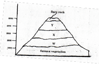
- The diagram below represents zones of natural vegetation on mountain in Africa. Use it to answer question (a) i and (a) ii
-
- Name the vegetation zones marked W, X and Y. (1mark)
- Describe the characteristics of the savannah vegetation. (6marks)
- Name the temperate grasslands found in the following countries. (3marks)
- Canada
- Russia
- Australia
- Explain three causes of the decline of the areas under forest in Kenya (6marks)
- You are supposed to carry out a field study on the uses of vegetation in the area near your school.
- State three reasons why it would be necessary to visit the area before the day of study. (3marks)
- Give four uses of vegetation you are likely to identify during the study. (4marks)
-
-
-
- What is a river divide? (2marks)
- Describe three ways by which rivers transport their load. (6marks)
- State the characteristics of a river in its old stage. (6marks)
- Describe each of the following drainage pattern and system;
- Super- imposed drainage system (3marks)
- Centripetal drainage pattern (2marks)
- You have planned to carry out a study of a river in its youthful stage.
- State two ways in which you would prepare for the study (2marks)
- Name two features you are likely to study (2marks)
- List two problems you are likely to experience during the study. (2marks)
-
-
-
- What is soil Catena? (2marks)
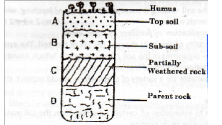
- Draw a well labelled diagram to show a well-developed soil profile. (5marks)
- State three characteristics of soils found in the arid regions of Kenya. (3marks)
- Give three factors that determine the colour of the soil (3marks)
- Describe how laterization occurs. (6marks)
- Explain how the following farming practices cause soil degeneration.
- Burning. (2marks)
- Continuous application of fertilizer on farm lands (2marks)
- Monoculture (2marks)
-

MARKING SCHEME
SECTION A
Answer all questions
-
- What is the shape of the earth? (1mk)
✓ Oblate spheroid/Geoid. - Give two reasons why the earth has the spherical shape (4mks)
✓ The earth experiences the force of gravity pulling towards the centre which creates a rounding effect on its shape
✓ The North and south poles experience centripetal force which constantly pulls towards each other causing flattened at the poles.
✓ At the equator the earth experiences the centrifugal force which causes the bulge.
- What is the shape of the earth? (1mk)
-
- Give the two dates in a year during which the number of hours of darkness and daytime is equal in both the north and south poles. (2mks)
✓ 21st march and 23rd September - Why do the lengths of days and nights vary from one part of the earth to another? (3mks)
✓ Because the earth is tilted in its axis.
✓ Because of the apparent movement of the sun within the tropical.
✓ Because of the revolution of thee arth.
- Give the two dates in a year during which the number of hours of darkness and daytime is equal in both the north and south poles. (2mks)
-
- Name two scales two scales used to measure the intensity of an earthquake. (2mks)
✓ Rossi-forrel scale
✓ The mercalli scale - Give three natural causes of earthquakes (3mks)
✓ Gravitative pressure.
✓ Collision of the tectonic plates.
✓ Energy release in the mantle.
✓ Isostatic adjustment.
✓ Violent volcanic eruptions.
✓ Magma movement within the crust.
- Name two scales two scales used to measure the intensity of an earthquake. (2mks)
- State five factors that influence mass wasting (5mks)
✓ Earthquake shocks lead to the movement of materials downslope
✓ Increased deeply weathered rock materials are likely to move downslope
✓ Increase in moisture lubricates the soil.
✓ Lack of vegetation reduces the ability of the soil to hold together.
✓ Under cutting of the slope by excavation
✓ Rearrangement of particles by living organism in the soil
✓ The angle of slope determines the movement of the material.
✓ The nature of underlying rock -
- What is the difference between an ice sheet and an iceberg? (2mks)
✓ Ice sheet is a continuous mass of ice covering vast of land while an iceberg is a large block ofice (broken from sheets) floating in seas/oceans. - Name three types of glacial moraines. (3mks)
✓ Lateral moraine
✓ Medial moraine
✓ Ground/sub-glacial moraine
✓ Terminal moraine
SECTION B
Answer question 6 and any other two questions from this section
- What is the difference between an ice sheet and an iceberg? (2mks)
- Study the map of Kijabe 1:50,000 provided and answer the following questions
-
- what is the approximate hegth of the top of Kijabe hill? (2mks)
✓ 2661m-2679m. - Measure the length of Nairobi-Naivasha railway line from landhies (257978) to the level crossing near Kijabe station (308984). Give your answer in kilometres. (2mks)
✓ 5.6km±0.1 - What relief feature on the map may have created problems in the construction of the railway line (2mks)
✓ Escarpment/steep slopes/kijabe hill
- what is the approximate hegth of the top of Kijabe hill? (2mks)
- Describe the drainage of the area covered by the map. (6mks)
✓ The main drainage features are rivers.
✓ There are many permanent rivers.
✓ Theres presence of hot springs.
✓ Rivers originating from Kijabe hill are short and disappearing underground.
✓ Rivers on Kijabe hill form parallel and radial drainage pattern.
✓ Most rivers form dendritic drainage pattern.
✓ Main rivers are upper Ewaso Kedong and Bathi which flow Southwards.
✓ Most rivers are in their youthful stage - Explain how relief has influenced the distribution of settlement in the area covered (6mks)
✓ Most of the settlement are foundat the foot-tof the escarpment because the land is sloping
✓ The escarpment has no settlement because the land is steep.
✓ Kijabe hill has a few settlement on the eastern side because the land is gently sloping
✓ The western side of the hill has no settlement as the land is steep.
✓ The land immediate to the east of the escarpment has many settlement because it is plateau/gently sloping - Citing evidence from the map, state three economic activities carried out in the area covered by the map (6mks)
Economic activities Evidence 1.Foresty
2.Cattle keeping
3.Quarrying
4.Transportation
5.Trading
6.Processing/Manufacturing
7.AgricultureForestry/Forest guard post
Dairy/cattle dip
Murram pit
Road,Railway/Tracks
Shops
Kagwe carbacid Plant
Plantations - What is the latitudinal extend of the area covered by the map (1mk)
✓ 0º53’s to 1º00’s.
-
-
- Describe the following characteristic of minerals.
- Colour 2mks)
✓ All minerals have their specific colour some changes colour when exposed e.g gold is yellow,copper oxides are blue or green. - Cleavage (2mks)
✓ Minerals have distinct cleavages.They have pattern in which they split or divide e.g mica split in to thin layers,glass break irregularly.
✓ Some breaks regularly - Hardness
✓ Minerals differ in hardness e.g Taclis soft Quartz is moderately hard and diamond is the hardest
- Colour 2mks)
-
- Give two types of igneous rocks (2mks)
✓ Intrusive /plutonic rocks
✓ Extrusive rocks
✓ Hypabyssal rocks. - Explain three conditions necessary for the growth of coral polyps (6mks)
✓ Warm waters of 20-30ºc for survival of polyps and planktons which serve as food for the polyps
✓ Shallow waters for sunlight to penetrate and allow growth of phyto plankton.
✓ Clear waters for air circulation.
✓ Saline water for polyps to extract lime to make their skeletons.
- Give two types of igneous rocks (2mks)
- Sate four uses of rocks (4mks)
✓ Rocks weather to form soiluse for agriculture.
✓ Rocks store under ground water(aquifers)
✓ Some rocks are source of salts.E.g.soda ash.
✓ Some sedimentary rocks have nitrates,potash which are used for making dyes,fertilizers
✓ Rocks e.g granite and lime stone are used for building purpose.
✓ Some rocks form fascinating features which attract tourist.E.g granitictors
✓ Some rocks are used as fuel e.g coal - You are planning to carry out a field study on the rocks within your school environment.
- Give two secondary sources of information you would use to prepare for the field study (2mks)
✓ Journals
✓ Magazines
✓ Newspapers
✓ Maps
✓ Extracts downloaded from the internet
✓ Books
✓ Statistical abstracts - State why you need the following items during the field study
- A fork jembe (1mk)
✓ Digging
✓ Hitting the rocks to determine their hardness. - Polythene bag (1mk)
✓ For holding and carrying rocks samples to school for further analysis
- A fork jembe (1mk)
- Suppose during the field study you collected marble, sandstone and granitjes, classify each of these samples according to its mode of formation (3mks)
✓ Marble -metamorphic
✓ granite -igneous
✓ sandstone -sedimentary
- Give two secondary sources of information you would use to prepare for the field study (2mks)
- Describe the following characteristic of minerals.
- The diagram below represents zones of natural vegetation on mountain in Africa. Use it to answer question
-
- Name the vegetation zones marked W, X and Y
✓ W- Tropical rain forest (1mk)
✓ X - Bamboo forest (1mk)
✓ Y - Heath and moorland (1mk) - Describe the characteristics of the savanna vegetation (6mks)
✓ Consist of trees and grass
✓ Wetter areas consist of tall scattered trees
✓ The wetter areas also have tall grass.
✓ Some trees are deciduous.
✓ The most common tree species are umbrella–shape.
✓ The most common tree species are acacia.
✓ There scattered baobab trees. - Name the temperate grasslands found in the following counties.
✓ Canada -Prairies (1mk)
✓ Russia -Steppes (1mk)
✓ Australia -Downs (1mk)
- Name the vegetation zones marked W, X and Y
- Explain three causes of the decline of the areas under forest in Kenya (6mks)
✓ Fire out breaks destroyed large tract of forest which take long to recover
✓ Pest and Parasites attack mainly the planted forest causing many trees to die.
✓ Human activities have destroyed many forest areas,many of which are transformed into farms or grasslands.
✓ Over–exploitation leads to depletion of certain tree species such as MeruOak,Camphor, and ElgonTeak.These trees take long to mature.
✓ Government policy of degazeting of some forest made people free to clear many forested areas.
✓ Prolonged droughts leads to degeneration of forest some of which take long to recover. - You are supposed to carry out a field study on the uses of vegetation in the area near your school.
- State three reasons why it would be necessary to visit the area before the day of study (3mks)
✓ To familiarize in order to design the appropriate research method
✓ To prepare the working schedule
✓ To be able to formulate the appropriate objectives and hypothesis.
✓ To be able to identify relevant equipment for data collection.
✓ To identify suitable areas for study to meet the people who will provide information during the study.
✓ To seek permission from the owners of the land/authorities. - Give four uses of vegetation you are likely to identify during the study. (4mks)
✓ Use as fodder.
✓ Use for providing fruits/roots/vegetables.
✓ Controlling soile rosion.
✓ For aesthetic value/beauty.
✓ For cultural/worship.
✓ Providing building construction materials/
- State three reasons why it would be necessary to visit the area before the day of study (3mks)
-
-
-
- What is a river divide? (2mks)
✓ It is a high ground that separates two or more river basins - Describe three ways by which rivers transport its load. (6mks)
✓ Traction process/rolling/sliding–the large heavy particles of the rivers load are rolled/dragged along the river bed.
✓ Saltation process–particles that are not too heavy but cannot remain suspended in water are momentarily lifted by the water turbulence and at times dropped on to the river bed.(short jumps and hops).
✓ Solution –soluble minerals are dissolved in the river water and carried away in solution.
✓ Suspension_light particles of the load are carried and maintained within the turbulence of flowing water.
- What is a river divide? (2mks)
- Describe the characteristics of a river in its old stage (6mks)
✓ The widening of the valley through lateral erosion.
✓ The speed of flow is low
✓ The river forms pronounced meanders.
✓ The mainwork of the riverside position.
✓ There are raised river beds.
✓ Rivers forms braided channels
✓ Rivers carries alot of sediments
✓ Rivers floods on the flood plains.
✓ large water volume. - Describe each of the following drainage patterns:
- Super-imposed drainage system (3mks)
✓ The drainage system develops on a rock structure that overlays a totally different one
✓ The river valley cuts through the surface rock layer onto the underlying rocks now become exposed.
✓ The super imposed drainage system bears no relationship to the existing rock structure. - Centripetal drainage pattern (2mks)
✓ The pattern develops in an area with a central basin.
✓ Rivers drain in to the depression from different directions.
- Super-imposed drainage system (3mks)
- You have planned to carry out a study of a river in its youthful stage.
- State two ways in which you would prepare for the study (2mks)
✓ Carry out reconnaissance
✓ Read from reference books.
✓ Seek permission from the authority.
✓ prepare a sketch map
✓ Formulate objectives for the study.
✓ Formulate hypothesis of study.
✓ Prepare relevant stationary - Name two features you are likely to study (2mks)
✓ Interlocking spurs
✓ Gorges.
✓ Waterfalls/rapids/cataracts
✓ Potholes - List two problems you are likely to experience during the study. (2mks)
✓ Steep slopes which make movement difficult
✓ Thick vegetation interfering movement.
✓ Rocky contours causing injuries.
✓ Hot/high temp/heavy downpour.
- State two ways in which you would prepare for the study (2mks)
-
-
-
- What is soil Catena? (2mks)
✓ It is the sequence of different soils from the parent rock on a slope - Draw a well labelled diagram to show a well developed soil profile (5mks)
- State three characteristics of soils found in the arid regions of Kenya (3mks)
✓ Are light in colour
✓ Are saline
✓ Are sandy/stony.
✓ Are loose in texture
✓ Are thin
✓ Have low moisture content
- What is soil Catena? (2mks)
- Give three factors that determine the colour of the soil (3mks)
✓ the types of parent rock.
✓ the amount of organic matter/humus.
✓ the chemical composition of minerals
✓ the amount of water in the soil - Describe how laterization occurs (6mks)
✓ During the rainy season,mineral salts in the top layer of the soil dissolve in rain water.
✓ The dissolved minerals percolate/seep downwards from the top soil to the sub-soil. (Silica and bases).
✓ The dissolved mineral move or are deposited further downwards to the lower layers.
✓ Insoluble minerals such as iron and aluminium accumulate on the top layer to form a crustoflaterites. - Explain how the following farming practices cause soil erosion.
- Burning. (2mks)
✓ Burning destroys micro-organisms which are essential for the formation of humus which binds soil particles together.
✓ Burning destroys vegetative matter that protects the soil against erosion.
✓ Burning destroys nitrogen fixing bacteria making the soil less fertile.
✓ Burning loosens the soil making it susceptible to erosion. - Continuous application of fertilizer on farm lands (2mks)
✓ It increases the acidity of the soil which destroys the micro-organism in the soil which could have helped in the formation of humus.
✓ Acidic soils are unsuitable fo ra variety of crops which would protect the soil from erosion - Monoculture (2mks)
✓ Leads to exhaustion of certain minerals from soil making it infertile and bare leading to its erosion.
✓ Monoculture leads to loosening of soils particles there by encouraging soil erosion.
- Burning. (2mks)
-
Join our whatsapp group for latest updates
Tap Here to Download for 50/-
Get on WhatsApp for 50/-
Download Geography Paper 1 Questions and Answers - Momaliche Joint Mock Exams 2021/2022.
Tap Here to Download for 50/-
Get on WhatsApp for 50/-
Why download?
- ✔ To read offline at any time.
- ✔ To Print at your convenience
- ✔ Share Easily with Friends / Students


