
QUESTIONS
WAKABA AREA
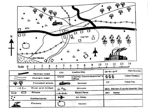
Study the map of Wakaba area and answer questions 1-8.
- The flow of the river can be described as (1mk)
- Who is the most senior government officer in Wakaba area? (1mk)
- Name four economic activities practiced by the people in Wakaba area. ( 4 mks)
- Which is the fastest means of transport used in the area? (1mk)
- Identify two functions of the police post in Dogo town. (2mks)
- Which other crop can be grown in the South Eastern part of Wakaba area? (1 mk)
- The population in the southern part of the Wakaba area can be described as (1mk)
- What is the main reason that influenced the location of Dogo town? (1 mk)
- Grade 7 pupils were discussing on the importance of Social Studies. State three points they were likely to have mentioned? (3 mks)
- Joseph identified the following careers related to Social Studies. Describe the careers stated below. (4 mks)
- Meteorology -
- Cartography -
- During a group discussion, grade 7 learners were requested to name the continents of the world. List three continents they were likely to have stated. (6 mks)
- The time in Nairobi 36°E is 8:00 am. What is the time in Free Town 15°W? (3 mks)
- Below are types of maps mentioned by Alex. Define each type of map. (6mks)
- Atlas maps
- Sketch maps
- Topography maps
- Grade 7 pupils were watching a video clip on the origin of the solar system.
Name two theories that they were likely to have identified. (2mks) - Gladys was planning to model the solar system. Identify four materials she needed. (4 mks)
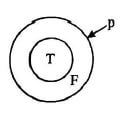
- Mitchell drew the figure below. Name the parts labeled P, F and T.(3 mks)

P-
F-
T- - During a Social Studies lesson, learners were required to state the elements of weather.
Name two correct responses they were likely to have stated. (2 mks)
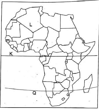
Use the map below to correctly answer questions 18 to 20.
- Name two countries crossed by the imaginary line marked Q (2mks)
- Which months of the year is the sun overhead the imaginary line marked K? (1mks)
- Name two countries crossed by the imaginary line marked L (2mks)
MARKING SCHEME
- From the Northern part to the South Western part of the area.
- County commissioner
- Trading, mining, cattle keeping, crop farming.
- Air transport
- Maintaining law and order, Arresting law breakers.
- Sisal
- Sparse population
- The road junction.
-
- It enables learners to understand how different issues in the past were handled
- Enables learners to identify and utilize resources in the locality
- Helps learners to make informed decisions on their choices
-
- Meteorology. The science of studying and predicting what the weather will be.
- Cartography the art of making maps and charts.
- Africa, North America, South America, Europe, Asia, Australia and Antarctica
- 0440hrs.
-
- Atlas maps. This is a special book with a collection of maps.
- Sketch maps This is a map drawn showing specific informa tion in a given area.
- Topography mape Maps used to describe the surface features in an area drawn to scale.
- Passing star theory and Nebula cloud theory.
- Clay/plasticine, painting brushes, water, water colours, wire or strings.
-
- P-Crust,
- T-Core,
- F- Mantle
- Temperature, sunshine, humidity, precipitation, wind and cloud cover.
- Namibia, Botswana, South Africa. Mozambique
- March and September
- Algeria, Libya , Egypt , Mauritania
Join our whatsapp group for latest updates
Tap Here to Download for 30/-
Get on WhatsApp for 30/-
Download Social Studies Questions and Answers - Grade 7 Mid Term 2 Exams 2023 Set 2.
Tap Here to Download for 30/-
Get on WhatsApp for 30/-
Why download?
- ✔ To read offline at any time.
- ✔ To Print at your convenience
- ✔ Share Easily with Friends / Students