
SECTION A
Answer all questions in this section.
-
- What is the relationship between Geography and Mathematics? (2 marks)
- State four reasons why it is important to study Geography. (4 marks)
-
- Name two layers of discontinuity that are part of the interior structure of the earth. (2 marks)
- State three characteristics of the outer core in the interior structure of the earth.
-
- Name two forms of precipitation that commonly occur in Kenya. (2 marks)
- What is a Stevensons screen? (2 marks)
-
- Identify two causes of earth movement. (2 marks).
- The diagram below shows some features formed as a result of faulting.
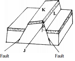
Identify:- The angle marked J. (1 mark)
- the features marked K and L. (2 marks)
-
- Identify two sources of water found in a lake. (2 marks)
- Give three characteristics of lakes formed due to faulting. (3 marks)
SECTION B
Answer question 6 and any other two questions in this section.
- Study the map of Kitale 1:50,000 sheet (75/3) provided and answer the following questions.
-
- Identify the two human made features found at the grid square 2320. (2 marks)
- What is the altitude of the highest point in the area covered by the map? (2 marks)
- Give three types of natural vegetation found in the area covered by the map. (3 marks
-
- What is the bearing of the Air Photo Principal Point at grid square 3426 from the Air Photo point at grid square 2931? (2 marks)
- Measure the distance of the dry weather road (C 640) from the junction at point M (345142) to the junction at point N (416201). Give your answer in kilometers. (2 marks)
-
- Using a scale of 1 cm to represent 40 metres, draw a cross section from grid reference 410180 to the grid reference 500180. (4 marks)
- On the cross-section, mark and name the following;
- A dry weather road; (1 mark)
- River Kaptarit; (1 mark)
- A ridge. (1 mark)
- Calculate the vertical exaggeration (VE) of the section. (2 marks)
- Citing evidence irons the map, identify five social services offered in Kitale Municipality.
-
-
-
- What is a mineral?(2 marks)
- Describe the following characteristics of minerals:
- Lustre; (2 marks)
- Colour; (2 marks)
- Density. (2 marks)
-
- Name two examples of extrusive igneous rocks. (2 marks)
- Describe three ways in which sedimentary rocks are formed. (9 marks)
- Explain the significance of rocks to the economy of Kenya under the following subheadings;
- tourism; (2 marks)
- energy; (2 marks)
- water. (2 marks)
-
-
- Explain the following processes of weathering;
- Hydration; (2 marks)
- Oxidation; (2 marks)
- Frost action. (3 marks)
- Describe how an exfoliation dome is formed. (6 marks)
- Explain three physical factors that enhance movement of materials along a slope due to gravity. (6 marks)
-
- Give two processes of rapid mass movement. (2 marks)
- State four indicators of occurrence of soil creep in an area. (4 marks)
- Explain the following processes of weathering;
-
-
- Outline two factors that influence the development of drainage patterns. (2 marks)
- Outline five characteristics of the river in its youthful stage. (5 marks)
- Describe the following processes of river erosion:
- attrition; (2 marks)
- corrasion; (4marks)
- Explain three negative effects of the rivers to human environment. (3 marks)
- Your class is planning to carry out a field study of a river in its old stage. (3 marks)
- State three reasons why it would be necessary to pre-visit the area of study. (3 marks)
- State three activities you would carry out to determine why deposition occurs at this stage
-
-
-
- Define the term soil (2 marks)
- Give two factors that determine soil leaching. (2 marks)
- Explain how the following factors influence soil formation:
- parent rock; (4 marks)
- biotic factors; (4 marks)
-
- State three characteristics of desert soils. (3 marks)
- Give two economic uses of soils. (2 marks)
- You are supposed to carry out a field study of an eroded area.
- What information would you collect through observation that would indicate that the area is severly eroded? (2 marks)
- Identify three methods you would use to record the observations. (3 marks)
- State three recommendations you sould give to contro; soil erosion. (3 marks)
-

MARKING SCHEME
-
- The relationship between Geography and Mathematics?
- Mathematics principles/formulae are used in Geography to calculate distance/area/ population density.
- Geography information can be analysed / presented accurately through the application of mathematical techniques.
- Geographical concepts are applied in calculating direction /bearing in mathematics
- State four reasons why it is important to study Geography.
- It helps to develop skills.
- It enables learners to understand/appreciate different environmental influences.
- It encourages international awareness/co-operation.
- It helps learners to appreciate important social values.
- It promotes positive attitudes towards protection/ of resources.
- It leads to development of career opportunities
- It helps learners to manage time properly
- It enables learners to explain the origin and formation of the earth and the landforms.
- The relationship between Geography and Mathematics?
-
- Name the two layers, of discontinuity that make up the interior structure of the earth. 2x1=2 marks
- mohorovicic/moho/mohor
- Gutenburg
- State three characteristics of the outer core in the interior structure of the earth.
- outer core is composed of molten rock material .
- it is made up of iron and nickel
- it is estimated to be about 2100km to 2890km thick.
- it has temperatures ranging from 3700°C to 5000°C
- it has an average density of 10.0gm/cc to I2/3gm/cc.
Any first 3x1
- Name the two layers, of discontinuity that make up the interior structure of the earth. 2x1=2 marks
-
- Name two forms of precipitation that commonly occur in Kenya.
- rain.
- hail.
- dew.
- fog/mist.
- What is a Stevensons screen?
- It is a white wooden box in which meteorological instruments are kept at a weather station.
(2 marks)
- It is a white wooden box in which meteorological instruments are kept at a weather station.
- Name two forms of precipitation that commonly occur in Kenya.
-
- Identify two causes of earth movement.
- magma movement within the crust.
- gravitational pull/ gravitative pressure
- Convectional currents in the mantle.
- isostatic adjustment.
any 2 x 1-2 marks
- Identify-
- the angle marked J
- Hade.
- the features marked.
- K- tilt block.
- L - fault scarp /escarpment.
- the angle marked J
- Identify two causes of earth movement.
-
- Identify two sources of water found in a lake.
- rainwater;
- rivers;
- underground water;
- glacial melt waters.
- Give three characteristics of lakes formed due to faulting.
- most are narrow;
- most are steep-sided; ,
- most are deep;
- most of them are salty;
- most of them are long.
Any 1st 3 x 1
- Identify two sources of water found in a lake.
- Study the map of Kitale 1:50,000 (sheet 75/3) provided and answer the following questions.
-
- identify two human made features found at the grid square 2320.
- bridge/me call's bridge.
- All weather road loose surface. 2x1=2 marks
- What is the altitude of the highest point in the area covered by the map?
- 2362 metres.
- Give three types of natural vegetation found in the area covered by the map
- forest
- scrub
- woodland
- scattered trees
- riverine trees
- papyrus vegetation
- thickets
any 3 x 1 = 3 marks
- identify two human made features found at the grid square 2320.
-
- What is the bearing of the Air Photo Principal Point at gridsquare 3426 from the air photo principal point at gridsquare 2931?
- 132° (131-133) (2 marks)
- Measure the distance of the dry weather road (C640) from the junction at point M (345142) to the junction at point N (416201). Give your answer in kilometres.
12.1km ± 0.1 (12.0-12.2) (2 marks)
- What is the bearing of the Air Photo Principal Point at gridsquare 3426 from the air photo principal point at gridsquare 2931?
-
- Using a scale of 1cm to represent 40 metres, draw a cross-section from grid reference 410180 to grid reference 500180.
- On the cross-section mark and name the following:
- A dry weather road.
- River Kaptarit
- A ridge. (3 x 1 marks)
- Calculate the vertical exaggeration (VE) of the section.
VE = VS/HS
VE = 1 ÷ 1
4000 50000
= 1 × 50000
4000 1
=12½ or 12.5
- Using a scale of 1cm to represent 40 metres, draw a cross-section from grid reference 410180 to grid reference 500180.
- Citing evidence irons the map, identify five social services offered in Kitale Municipality.
5 x 1 (5 marks)Services Evidence Health/medical
Recreational services
Religious services
Security Services
Housing
Water supply
Burial servicesPresence of hospital
Sports club/KitaJe Club/Golf Course
Church
Police station/D.C Office
Built-up areas/huts
Water tower/tank
Cemetry
-
-
-
- What is a mineral?
- Mineral is an inorganic substance with a definite chemical composition at/ beneath the surface of the earth /a solid inorganic substance occurring naturally (2 marks)
- Describe the following characteristics of minerals.
- Lustre - minerals differ in their brightness depending on the nature of their reflective surfaces Smooth surfaces are shiny whereas rough surfaces are dull
- Colour - different minerals display different colours. (Minerals that have iron / magnesium have dark colours/
(2-marks) - Density - minerals have different Weight per unit volume of waterminerals have different specific gravity/some minerals are heavier while others are light
(2 marks)
- What is a mineral?
-
- Name two examples of extrusive igneous rocks.
- Basalt
- Rhyolite
- tefra
- Pumice
- obsidian
- phonolites
- Tuff
- Andesite
- Trachyte
- Scoria
any 2 x 1 = 2 marks
- Describe three ways in which sedimentary rocks are formed.
- Mechanically formed sedimentary rocks - rock fragments are transported by wind/water/ice They are deposited in layers. Over a long period of time, they are compacted into a hard rock?
- Organically formed sedimentary rocks - remains of plants/animals are deposited in layers. Over a long period of time, the remains are compacted forming a hard rock.
- Chemically formed sedimentary rocks - dissolved minerals are transported into water bodies They are then precipitates /evaporates over a long Period ; time, the precipitates/evaporites are then compacted to form a hard rock .
3 x 1 = 3 marks
- Name two examples of extrusive igneous rocks.
- Explain the significance of rocks to the economy of Kenya under the following:
- Tourism: Some rocks form unique features that attract tourists earning the country foreign exchange/income. (2 marks)
- Energy: Some sedimentary rocks contains fossils fuels which are sources of energy for domestic/industrial use (2 marks)
- Water: Some rocks act as storage for water which Can be supplied for domestic / industrial / agricultural use. (2 marks)
-
-
- Explain the following processes of weathering:
- Hydration: In hydration certain rock minerals absorb water thus expanding this causes internal stress in the rock and it eventually disintegrates.
- Oxidation :takes place in rocks that contain iron. The iron combines with oxygen forming iron oxides Such rocks change colour and crumble easily.
- Frost action
- In temperate/high mountain areas, water may occupy cracks in the rocks during the day.
- At night the temperatures drop below freezing point causing the water to freeze and expand.
- This is alternate freeze-thaw action weakens the rock causing it to disintegrate.
( 3 marks)
- Describe how an exfoliation dome is formed.
- In arid/semi and areas, there is large diurnal ranges of temperature.
- During the day, a homogenous rock, intensely heated/at night the rock looses heat rapidly.
- The differential heating causes the outer layer to expand/contract faster than the inner layer.
- When this expansion and contraction takes place repeatedly, stress develops in the outer layer of rocks. Cracks appear on the surface layer.
- Eventually, the outer layer peels off .
- The peeling off leaves behind a rounded mass of rock known as exfoliation dome.
any 6x1=6 marks
- Explain three physical factors that enhance movement of materials along a slope due to gravity.
- Nature of materials
- Heavy and large materials move faster on a slope as they are more likely to be overcome by gravity/thinly bedded layers have a tendency to move faster.
- Angle of slope
- The steeper the slope, the faster the rate of movement/where rocks are dipping steeply, movement is faster.
- Climatic factors/amount of water.
- The more saturated the rock/soil materials is, the more likely it is to move as water adds weight and lubricates/alternate freezing and thawing encourages movement.
- Vegetation cover
- Bare surfaces are more likely to experience mass wasting because there is no vegetation to bind the materials together
- Earth movements.
- Earthquakes/volcanic eruptions/isostatic adjustments cause vibrations which may trigger widespread movement of weathered rock materials
any 3 x 2 = 6 marks
- Earthquakes/volcanic eruptions/isostatic adjustments cause vibrations which may trigger widespread movement of weathered rock materials
- Nature of materials
-
- Give two processes, of rapid mass movement.
- landslides/slumping/rockslide/rckfall/debris slide/debris fall/avalanche
- mudslides/mudflow
- earthflows/ eathslides
any 2 x 1 = 2 marks
- State four indicators of occurrence of soil creep in an area.
- Telephone/fence poles that are inclined down a slope/bent tree trunks.
- Accumulated soil at the foot of a slope/behind obstacles such as walls/on roads/railways
- Existence of bare rock/exposed upper slope.
- Presence of a ribbed/stepped pattern across the slope.
- Presence of dipped rock strata in the direction of the slope.
- presence of overhanging banks above roads/rivers.
- presence of a slope retreat
any 4 x 1 = 4 marks
- Give two processes, of rapid mass movement.
- Explain the following processes of weathering:
-
-
- Outline two factors that influence the development of drainage patterns.
- Direction of the slope of the land.
- Difference in rock resistance /hardness.
- The arrangement of rock layers/rock structure
- Faulting/fault guided
any 2 x 1 = 2 marks
- Outline five characteristics of a river in its youthful stage.
- the river has a steep river gradient.
- the river channel is narrow.
- the river has deep/steep-sided/V-shaped valley
- the river flows at a high speed/high stream velocity.
- the vertical erosion/down cutting is dorminant.
- the river channel is generally winding
- Erosional features are common rapids/waterfalls/cataracts/cascades/ interlocking spurs/potholes/ plunge pools/
- the type of flow is torrential.
- the river has a small load
- the river has a small volume of water
any 5 x 1 = 5 marks
- Outline two factors that influence the development of drainage patterns.
- Describe the following processes of river erosion.
- Attrition: As rock materials are transported downstream, they constantly collide against each other.
The materials gradually wear down/reduce in sizes - Corrasion : As solid rock materials are transported downstream, they are hurled against the banks and draped along the river bed.
The rock materials scour/erode/chip offf pieces of rock from the channel and the river bed.
The rock materials scour/smoothen/grind the river bank/bed
Eddy currents rotate pieces of rock around the hollows breaking/ grinding the river bed.
(4 marks)
- Attrition: As rock materials are transported downstream, they constantly collide against each other.
- Explain three negative effects of rivers to the human environment.
- When rivers flood, they destroy a lot of property/crops lead to loss of human life.
- Wide/deep rivers are a barrier to transport especially where bridges have not been constructed.
- River water can be a medium of spreading water-born diseases, since flood waters may spread chemicals from farms/human waste which contaminates sources of water
- Some rivers are habitat to dangerous animals which may attack human beings/destroy crops.
any 3 x 2 = 6 marks
- Your class is planning to carry out a field study of a river in its old stage,
- State three reasons why it would be necessary to pre-visit the area of study.
- It helps to draw up objectives/hypothesis for the study
- It helps to prepare a route map.
- it helps to design a working schedule.
- it helps to identify the probable problems/how to solve problems.
- it helps to asses the suitability of the study area.
- it helps to estiomate the cost of the study.
- it helps to identify siutable methods of collecting data.
- it helps to identify appropriate equipment to be used during the study.
any 3 x 1 = 3 marks
- State three activities you would carry out to determine why deposition occurs at this stage.
- Measuring of gradient
- Finding out the nature of the load.
- Finding out the amount of the load.
- Establishing the velocity of the river.
- Observing obstacles in the stream channel/distributaries.
- Measuring of the width of the river.
any 3x1=3 marks
- State three reasons why it would be necessary to pre-visit the area of study.
-
-
-
- Define the term soil.
- It is a naturally occurring thin layer of loose/unconsolidated materials which , overlies the crustal rocks and on which plants grow/It is an accumulation of rock particles/minerals, organic matter, water and air found on the surface of the earth.
(2mark)
- It is a naturally occurring thin layer of loose/unconsolidated materials which , overlies the crustal rocks and on which plants grow/It is an accumulation of rock particles/minerals, organic matter, water and air found on the surface of the earth.
- Give two factors that determine soil leaching?
- nature of soil/solubility of minerals.
- amount of rainfall
- nature of the slope
any 2x1=2 marks
- Define the term soil.
- Explain how the following factors influence soil formation.
- Parent rock
- The nature of rock influences the rate of weathering in that soft rock weather hard rock are resistant and weather slowly.
- The parent rock determines the soil texture in that large/coarse grained rocks produce large/coarse grained soils.
- The type of minerals in the parent rock are transferred to the soil during formation.
any 2x2 = 4 marks
- Biotic factors
- Micro organisms in the soil assist in plant/animal decay to form humus.
- The micro organisms mix and aerate the soils
- The roots of plants, penetrate the soil enabling it to become porous.
- ploughing/digging break up soil structure into small particles.
- when plants and animals die, they decay to form humus/organic matter in the soil.
any 2x2 = 4 marks
- Parent rock
-
- state three characteristics of desert soils
- The soils contain little of no humus.
- the soil are of sandy/stony texture.
- the soils are saline/contains a lot of salts/high lime content.
- the soils lack moisture.
- the soils may be light colored.
- the soils are thin/shallow
- the soils are lightly porous.
any 3x1 = 3 marks
- Give two economic uses of soil.
- It is used as raw material in industry/pottery/ glass making/ brick making.
- Soils support agriculture/development of forestry.
- Some soils contain valuable minerals.
- some soils have medicinal value./are foo
- it is used in building/construction
any 2x1 = 2 marks
- state three characteristics of desert soils
- You are supposed to carry out a field study of an eroded area.
- What information would you collect through observation that would indicate that the area is severely eroded?
- rills/gullies/deep trenches
- uneven surface.
- lack of or little vegetation.
- little/absence of topsoil/thin soils
- exposed plant roots.
any 2 x 1 = 2 marks
- Identify three methods you would use to record the observations.
- photograph taking
- video recording.
- note taking.
- field sketching.
- tabulation.
any 3x1 = 3 marks
- State three recommendations you would give to control soil erosion.
- construction of gabions.
- construction of check dams.
- afforestation/reafforestation.
- filling in the gullies.
- construction of drainage trenches.
- practising approriate methods of farming/ planting cover crops.
any 3 x 1=3 marks
- What information would you collect through observation that would indicate that the area is severely eroded?
-
Join our whatsapp group for latest updates
Tap Here to Download for 50/-
Get on WhatsApp for 50/-
Download KCSE 2012 Geography Paper 1 with Marking Scheme.
Tap Here to Download for 50/-
Get on WhatsApp for 50/-
Why download?
- ✔ To read offline at any time.
- ✔ To Print at your convenience
- ✔ Share Easily with Friends / Students


