
INSTRUCTIONS
- This paper has two sections, A and B.
- Answer all the questions in section A.
- Answer question 6 and any other two questions from section B.
SECTION A (25 MARKS)
Answer ALL questions in this section
-
- What is a planet? (2mks)
- State three characteristics of planets. (3mks)
-
- State two main features of the mantle. (2mks)
- Give reasons why the crustal rocks are solid and cooler than those of the mantle. (4mks)
-
- What is river rejuvenation? (2mks)
- State four ways in which rivers erode. (4mks)
-
- Name two mountains in East Africa that have glaciers. (2mks)
- Give the differences between nunataks and pyramidal peaks. (2mks)
-
- What is Biological weathering? (1mk)
- Briefly explain how block disintegration occurs in physical weathering. (3mks)
SECTION B (75 MARKS)
Answer QUESTION 6 and any other TWO questions
- Study the map of Kitale 1:50000 sheet 122/1 and answer the questions that follow.
-
- Name two human features found in grid square 2320. (2mks)
- State the latitude and longitude of the south east corner of the map. (2mks)
-
- What is the bearing ofair photo principal point at grid square 3426 from the air photo principal point at grid square 2931 (2mks)
- What is the length of the dry weather road (C640) from the junction at point M (345142) to the junction at point N (416201) give your answer in kilometer (2mks)
-
- Describe the relief of the area covered by the map. (5mks)
- Name three natural vegetation found in the area covered by the map. (3mks)
-
- Draw across section from point 410180 to grid reference 500180 using a scale of 1cm to represent 40 meters (4mks)
- Name three social services citing evidence offered in the area covered by the map. (5mks)
-
-
-
- What is a rock? (1mk)
- Outline the common characteristics of minerals. (4mks)
- The figure below shows a Map of Kenya showing rock distribution. Study it and answer the questions that follow
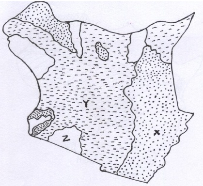
- Name the rocks marked x y &z. (3mks)
- Give reasons why the rocks marked x are common near Coast. (3mks)
-
- What is rock metamorphism. (2mks)
- Explain three process of rock metamorphism. (6mks)
- Explain the economic importance of rocks to people. (6mks)
-
-
-
- What is a desert. (2mks)
- Name three desert surfaces common in hot desert. (3mks)
-
- Give three reasons why wind is an effective erosion agent in hot deserts. (3mks)
- Explain how the artesian well is formed in deserts. (6mks)
- The diagram below shows different levels of underground water.
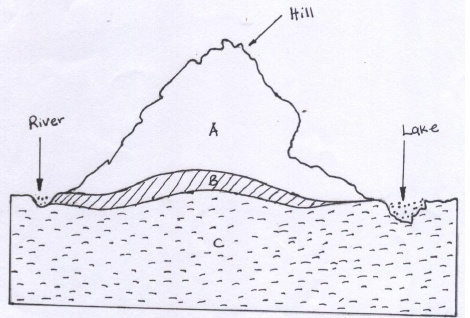
- Name the parts labelled A,B, and C. (3mks)
- Explain four ways in which under ground water influences human activities. (8mks)
-
-
-
- What is volcanicity. (2mks)
- State three characteristics of basic Lava. (3mks)
- Using diagrams, explain how a volcanic plateau is formed. (5mks)
- What is the economic significance of Batholiths to people. (4mks)
- Students at Kibabii high school carried out a field study on the Granitic Tors around their school.
- Why did they prepare a hypothesis? (2mks)
- What preparation did they undertake with their geography teachers? (4mks)
- State three main problems they encountered in the field. (3mks)
-
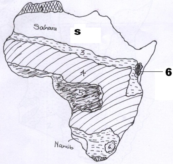
- The map of Africa, below shows main climatic regions labelled 1,3,4 5&6.
-
- Name the climatic regions labelled 1 to 6. (5mks)
- State the characteristics of the climatic region labelled S. (5mks)
- Name the main factor that influences the climatic region labelled 6. (1mk)
- Explain how vegetation has adopted in the climatic region labelled Sahara or Namib. (6mks)
-
- Name three water Towers in Kenya. (3mks)
- What measures have been taken to conserve forests in Kenya. (5 mks)
-
Join our whatsapp group for latest updates
Tap Here to Download for 50/-
Get on WhatsApp for 50/-
Download GEOGRAPHY PAPER 1 - 2019 KCSE Prediction Questions Set 2.
Tap Here to Download for 50/-
Get on WhatsApp for 50/-
Why download?
- ✔ To read offline at any time.
- ✔ To Print at your convenience
- ✔ Share Easily with Friends / Students


