
SECTION A
Answer all the questions in this section
-
- Define eco-tourism. (2mks)
- State three benefits of eco-tourism. (3mks)
-
- Name two counties in Kenya where wheat is grown in large scale. (2mks)
- List three problems facing wheat farmers in Kenya. (3mks)
-
- Give two types of domestic trade. (2mks)
- Statethree factors influencing internal trade in Kenya (3mks)
-
- Differentiate between environmental management and environmental conservation. (2mks)
- Give three natural environmental hazards you know. (3mks)
-
- Study the sketch map below and answer the questions that follow
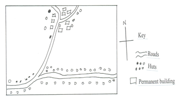
Identify two settlement patterns represented by the sketch map. (2mks) - State three causes of rural to rural migration. (3mks)
- Study the sketch map below and answer the questions that follow
-
- The table below shows East Africa’s milk production in ‘000’ litres from 1998 – 2001
Country /Year
1998
1999
2000
2001
Kenya
30
41
36
25
Uganda
20
25
27
29
Tanzania
52
60
65
70
- Draw a compound bar graph to represent the above data. Use a vertical scale of 1cm represents 10 ,000 litres. (7mks)
- State two limitations of compound bar graph in representing data. (2mks)
-
- Name three counties in Kenya where dairy farming is practiced in large scale. (3mks)
- State four similarities between dairy farming in Kenya and Denmark. (4mks)
-
- Mention three types of dairy animals reared in Kenya. (3mks)
- Explain three human factors favoring dairying in Denmark. (6mks)
- The table below shows East Africa’s milk production in ‘000’ litres from 1998 – 2001
-
-
- Distinguish between transport and communication. (2mk)
- Explain how construction of transport networks is affected by the following factors.
- Relief (2mks)
-Economic factors. (2mks)
-
- State four factors that hinder the development of air transport in Africa. (4mks)
- Name two canalsthat are found in Africa. (2mk)
- State five recent developmentthat have taken place in Kenya to improve communication. (5mks)
- Explain four ways in which transport and communication has improved economic development in Africa. (8mks)
-
-
-
- What is fishing? (2mks)
- Explain three ways in which the nature of coastline affects fishing. (6mks)
-
- State three types of fishing carried out in Kenya. (3mks)
- Describe seining as a modern method of fishing. (3 mks
- The map below shows the fishing ground East of the Asian Continent. Use it to answer thequestions that follow.
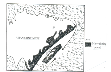
- Give the name given to the major fishing ground shown on the map. (1mk)
- Identify the ocean currents marked Q and R. (2mks)
- Explain four factors that havefavoredfishing in the ground mentioned in (i) above.(8mks)
-
-
-
- Apart from those in EastAfrica, name four large scale H.E.P projects in Africa (4mks)
- Other than water, give three other sources of renewable energy. (3mks)
- Explain four factors that have hindered full development of H.E.P production in Kenya (8mks)
- Mention four areas in Kenya with high potential for Geothermalpower. (4mks)
- A form four class in Machakoscountyis planning a field study to Gitaru H.E.P. dam.
- State three reasons why they need to inform the school authority. (3mks)
- Give three follow-up activities they engaged in school after the study. (3mks)
-
-
-
- What is industrialization? (2 mks)
- Explainthree reasons why some industries consider regular supply of water as the main reason for their location. (6 mks)
- Outline four similarities between Jua Kali industry in Kenya and cottage industry in India. (4 mks)
- Explain three factors that have influenced the location of iron and steel industry in the Ruhr region of Germany in the 19th century.(6 mks)
- You intend to carry out a field study in Thika industrial area.
- State foureffects of the industries on the environment you are likely to observe.(4mks)
- State three reasons why it is important to prepare a working schedule for the study. (3mks)
-

MARKING SCHEME
SECTION A
-
- Define eco-tourism. (2mks)
Eco-tourism is form of tourism where tourists travel to areas of interest with the aim of conserving the environment and at the same time enjoying and benefiting from it. - State three benefits of eco-tourism. (3mks)
- encourages wildlife conservation
- promotes market for local commodities (art & craft)
- reduces poaching/illegal hunting
- promote peaceful co-existence between people and wildlife
- creates employment opportunities to the local residences.
- Define eco-tourism. (2mks)
-
- Name two counties in Kenya where wheat is grown in large scale. (2mks)
- Uasin Gishu
- Meru
- Narok
- Laikipia
- Nakuru - State three problems facing wheat farmers in Kenya. (3mks)
- Attack by pest and diseases
- Famers Limited capital
- Climatic hazards / Heavy rainfall/ Draught
- Inadequate/ Poor storage
- Price fluctuation
- Name two counties in Kenya where wheat is grown in large scale. (2mks)
-
- Give two types of domestic trade. (2mks)
- Wholesale
- Retail
State three factors influencing internal trade in Kenya. (3mks)
- Availability of capital
- Availability of goods and services
- Availability of Security
- Demand for goods and services.
- Availability of transport and communication
- Trade restrictions
- Existence of aids to trade
- Give two types of domestic trade. (2mks)
-
- Differentiate between environmental management and environmental conservation.(2mks)
Environmental management is the planning to ensure effective and proper utilization of available resources in the environment while environmental conservation is the protection, preservation and proper utilization of resources in the environment so as to continue benefiting the present generation while maintaining its potential to meet the needs and aspirations of the future generations. - Give three natural environmental hazards you know. (3mks)
- Tropical cyclones
- Earthquakes
- Volcanic eruptions
- Water spouts
- Drought and desertification
- Windstorms
- Pests and diseases
- Lighting
- Differentiate between environmental management and environmental conservation.(2mks)
- Study the sketch map below and answer the questions that follow.
- Identify two settlement patterns represented by the sketch map. (2mks)
-Nucleated/clustered
- Linear - State three causes of rural to rural migration. (3mks)
- Establishment large plantations with jobs opportunities
- Nomadic pastoralists regularly move in search of water and pasture
- Population pressure people move from densely populated to less populated
- Establishment of settlement schemes
- Availability of rich farming land
- Identify two settlement patterns represented by the sketch map. (2mks)
-
- The table below shows East Africa’s milk production in ‘000’ litres from 1998 – 2001
- Draw a compound bar graph to represent the above data. Use a vertical of scale of 1cm represent 10 ,000 litres (7 marks )
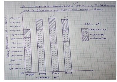
- State two limitations of compound bar graph in representing data. (2marks)
- Individual contribution made by components is difficult to trace
- Number of commodities which can be shown are limited by space upward
- Its tedious to draw/ take time to draw
- Poor choice of vertical scale causes exaggeration of length of the bars
- Draw a compound bar graph to represent the above data. Use a vertical of scale of 1cm represent 10 ,000 litres (7 marks )
-
- Name three counties in Kenya where dairy farming is practiced in large scale. (3mks)
- Meru - Embu
- Kirinyaga - Nyeri - Muranga
- Kiambu - Nyandarua - Nakuru
- Nandi - Uasin Gishu
- Meru - Embu
- State four similarities between dairy farming in Kenya and Denmark. (4mks)
- In both countries similar breeds are kept
- In both countries, dairy products are sold through cooperatives
- In both countries Artificial Insemination is done
- In both cases, few traditional breeds are kept. (Danish Red- Denmark, Zebu-Kenya)
- Name three counties in Kenya where dairy farming is practiced in large scale. (3mks)
-
- Mention three types of dairy animals reared in Kenya. (3mks
- Friesian - Jersey - Guernsey
- Alderney - Ayrshire - Sahiwal
- Explain three human factors favoring dairying in Denmark. (6mks)
- Availability of processed feeds to supplement natural grass
- Strict farming regulations set by the government and farmers organizations, instill discipline in the sector
- Use of advanced technology/ mechanization leading to efficiency in the sector
- Scientific research leading to high quality breeds with high yields
- Well organized cooperatives, hence high standard goods
- Wide market in and out the country
- Mention three types of dairy animals reared in Kenya. (3mks
- The table below shows East Africa’s milk production in ‘000’ litres from 1998 – 2001
-
-
- Distinguish between transport and communication. (2mk)
Transport is the physical movement of goods and or people from one place to another while communication is transfer of information from a person/ place to another - Explain how construction of transport networks is affected by the following factors.
- Relief (2mks)
Presence of relief features, such as mountains, valleys and escarpments increase the cost of constructing transport lines such as roads and railway lines through them
Bridges to be constructed across some feature like river valley add on the cost.
-Economic (2mks)
Tarmac roads railway lines are constructed in productive and densely populated areas as they are economically viable due to high demand and supply of goods
Availability of funds to construct and maintain transport lines also determines how developed they are in a country.
- Distinguish between transport and communication. (2mk)
-
- State four factors that hinder the development of air transport in Africa. (4mks)
- Limited carrying capacity offered by aircrafts
- The high cost of purchasing aircrafts and high cost of air transport
- It requires highly trained personnel with high technical expertise in the control and operation of aircrafts
- Inflexibility as it only serves areas where there are airports and airstrips
- restricted freedom of the air due to political difference and ideologies of leaders of African countries
- Inadequacy of air terminus - Name two canal that are found in Africa. (2mk)
- Suez canal
-Jonglee canal in Sudan
- State four factors that hinder the development of air transport in Africa. (4mks)
- State five recent development that have taken place in Kenya to improve communication. (5mks)
-Expansion of telephone facilities
- introduction of mobile phones and pager services
- liberalization of postal services
- licensing of more private radio stations and television stations
- liberalization of the press
- installation of fiber optic cables
- Installation of top-box (decoders) on the televisions - Explain four ways in which transport and communication has improved economic development in Africa. (8mks)
-It promotes industrial development by facilitating the movement of raw materials to the manufacturing centres and finished goods to the market.
- It promotes both local and international trade
- It promotes tourism by opening up potential sites
- It has opened up remote areas for exploitation especially through agriculture and mining
- It has enhanced interaction among people leading to exchange of technology
- it has enhanced mobility of labour to areas where needed hence increased and improved production.
- Development of settlements along the transport and communication routes hence urbanization.
- creation of employment opportunities hence raising the people’s living standards.
4 x 2 = 8
-
-
-
- What is fishing? (2marks)
- Fishing is the act of catching fish and other aquatic animals. - Explain three ways in which the nature of coastline affects fishing. (6mks)
- Continental shelf
Coastline that is shallow with wide continental shelf encourages growth of plankton thereby having large population of fish.
- Sheltered coastline
-A coastline that is sheltered from strong winds and ocean currents are popular breeding grounds for fish
- Indented coastline - An indented coastline encourages deep sea fishing as they allow the anchorage of large vessels and the development of ports.
- What is fishing? (2marks)
-
- State three types of fishing carried out in Kenya. (3mks)
- Pelagic fishing.
- Demersal fishing
- Inshore fishing
- Fresh water fishing
- Describe seining as a modern method of fishing. (3mks)
- Fishing boats with the help of dory (small) boats spread out the seine nets with small meshes in the sea.
- Once the nets have been spread out the boats may remain stationary or one boat moves round or both boats move toward certain direction.
- The net is held in position using floats and tied to some weights to keep it in water and open on one side.
- Once the net is full, it is hauled over and the fish emptied onto the ship / boat.
- Seining method is used to catch pelagic fish.
- State three types of fishing carried out in Kenya. (3mks)
- The map below shows the fishing ground East of the Asian Continent. Use it to answer the questions that follow.
- Give the name given to the major fishing ground shown on the map. (1mk)
- North West Pacific Fishing Ground - Identify the ocean currents marked Q and R. (2mks)
Q – Oyashio (Cold)
R – Kuroshio (Warm) - Explain four factors that have favored fishing in the ground mentioned in (i) above.(8mks)
- The rugged terrain – discourages agriculture resulting to fishing as one of the alternative source of livelihood.
- Extensive continental shelf – Japan has an extensive and shallow continental shelf that hosts a lot of fish.
- Convergence of warm Kuroshio and cold Oyashio currents provides a suitable habitat for plankton on which fish feed on.
- Indented North East Asian coastline with several islands, numerous bays and sheltered inlets favoring fish breeding
- Availability of ready market- high population in the Asian countries act as domestic and foreign market
- Advance technology in the region making efficient
- Modern and effective transport facilities offering quick movement of fish to the market
- Give the name given to the major fishing ground shown on the map. (1mk)
-
-
-
- Apart from those in East Africa, name four large scale H.E.P projects in Africa (4mks)
- Aswan high dam, river Nile
- Kariba dam, river Zambezi
- Cabora Bassa dam, river Zambezi
- Inga and le Marine dam, river Congo
- Kainji dam, river Niger
- Akosombo dam, river Volta - Other than water, give three other sources of renewable energy (3mks)
- The sun/solar
- Wind
- Wood/biomass
- Geothermal
- Draught animals
- Apart from those in East Africa, name four large scale H.E.P projects in Africa (4mks)
- Explain four factors that have hindered full development of Hydro-Electric-Power production in Kenya. (8mks)
- Most rivers in Kenya are small hence cannot generate a lot of power
- Most rivers in Kenya are seasonal hence cannot generate H.E.P throughout the year
- There are a few sites where H.E.P production can be done
- Inadequate capital that can be used in construction of H.E.P stations
- Low technology that can be used in the development of H.E.P
- Siltation of the reservoir hence reducing the volume/ capacity to produce power
- Displacement of people to pave way for dam construction
- Creation of reservoir leads to water bone diseases like malaria
- Separation of people and increase in distance between the two sides of the rive - Mention four areas in Kenya with high potential for Geothermal power. (4mks)
- L. Magadi
- Menengai Crater
- Olkaria
- L. Bogoria- Baringo
- Eburu
- L. Turkana - A form four class in Machakos county is planning a field study to Gitaru H.E.P. dam.
- State three reasons why they needed to inform the school authority. (3mks)
- For the school to provide transport
- To formally inform the school administration.
- For the school to adjust its program
- For the school to assist with various tools.
- For school to contact Gitaru dam office - Give three follow-up activities they engaged in school after the study. (3mks)
- Giving a brief report on the study to the rest of the school
- Holding discussion in groups
- Displaying and editing photographs and showing videos taken during the study
- Labeling samples
(Accept any other applicable activity)
- State three reasons why they needed to inform the school authority. (3mks)
-
-
-
- What is industrialization? (2mks)
It is the process / pace at which a country / community sets / establishes industries. It is the process of change from primary to secondary to tertiary production. It is the level of industrial production. - Explain three reasons why some industries consider regular supply of water as the main reason for their location. (6mks)
- Water is used for constant cooling of the machines to avoid damage by heat.
- In some industries, water is used for cleaning the raw materials/ to improve the quality of the final products/coffee industry.
- Some industries use water as a cheap means of transport.
- Some industries require water as a medium through which they dispose off their waste products.
- In coffee factories, water is used for grading coffee berries.
- Some industries use water to provide power to turn their machines.
- Some industries use water as the main raw materials / brewing industry / soft drink industry.
- What is industrialization? (2mks)
- Outline four similarities between Jua Kali industry in Kenya and cottage industry in India. (4mks)
-Both are operated by small individuals / groups
-Sometimes they are both practiced as part time
-Both of their products are sold in the local market / some can be exported
-They both use simple equipment.
-They both use basic / simple skills in craft.
-They both use local / recycled raw materials.
-They both require little capital investment to begin.
-They are both widespread in the country / in urban centers.
-They are mostly operated in open sheds / homes. / Simple enclosure.
-They are both labour intensive.
-In most cases, they are both owned by families. - Explain three factors that have influenced the location of iron and steel industry in the Ruhr region of Germany in the 19th century. (6mks)
-Presence of other industries in the region such as food and textile provided industrial inertia.
-Availability of coal / iron ore / limestone from within the region / Rhine Valley provided raw materials needed in the industry.
-The Dense and affluent population in western Europe / Germany provided ready market for iron and steel.
-Rich merchants and companies such as Kotile AC/ Krupp group provided capital for the establishment / development / of industries.
-Presence rivers such as Rhine/ Ruhr / Lipper /Wupper / Escher provided cheap means of transport for the bulky raw materials / finished products.
-Coal from the Ruhr region / imported petroleum provided power required in the industry.
-River Rhine / Ruhr / Lipper / Wupper / Escher provided water required for cooling machines in the industry / raw materials in the industry.
-The local population had acquired skills in the iron working / availability of local skilled labour which formed the foundation of iron and steel industry. - You intend to carry out a field study in Thika industrial area.
- State four effects of the industries on the environment you are likely to observe. (4mks)
- Smoke from chimneys polluting air / air pollution.
- Garbage heaps as a result of solid industrial waste polluting soil.
- Industrial discharge polluting water bodies / soil / biodiversity.
- A lot of noise causing noise pollution.
- State three reasons why it is important to prepare a working schedule for the study.(3mks)
- So as to work within the allocated time
- So as to stick to the topic
- So as to provide ample time to each activity
- So as to make sure that no activity is forgotten
- So as to be able to evaluate the progress
- So as to estimate time required
- State four effects of the industries on the environment you are likely to observe. (4mks)
-
Join our whatsapp group for latest updates
Tap Here to Download for 50/-
Get on WhatsApp for 50/-
Download GEOGRAPHY PAPER 2 - KCSE 2019 BAHATI MOCK EXAMINATION (WITH MARKING SCHEME).
Tap Here to Download for 50/-
Get on WhatsApp for 50/-
Why download?
- ✔ To read offline at any time.
- ✔ To Print at your convenience
- ✔ Share Easily with Friends / Students


