
SECTION A
Answer all the questions in this section
-
- What is Solar system?
- Name two dwarf planets
- State five characteristics of the sun.
-
- Give three reasons why temperature decreases with increasing latitude.
- Describe the following types of fog:
- Radiation fog
- Advection fog
- Use the following diagram below to answer the following questions:
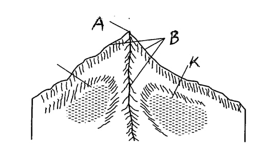
- Name the features marked A and B.
- Describe the formation of the feature marked K.
-
- Give the difference between glacial till deposits and fluvio-glacial deposits.
- Give three characteristics of the tides shown in the diagram below

- Study the map of Taita Hills 1:50,000 (sheet 189/4) provided and answer the following questions.
-
- Convert the map scale 1:50,000 to statement scale. Show your calculations.
- Find the bearing of Mwasungia 903 at grid reference 3922 from Mwasere at grid reference 3826.
- Measure the distance of the loose surface road from the junction (232142) to Mission Girls Secondary School (243187) in km.
- Draw a cross section between Kishamba (2921) and shops near Majengo (3617). (use vertical scale of 1cm rep 20 meters)
On your cross section, show the following.- Mwachawaza
- Majengo Shops
-
- Citing evidence, state three reasons why there is dense settlement in the western part of the map.
- Give four possible reasons that have enabled a commercial farming activity located on the southern part of the map.
SECTION B
Answer question 6 and any other two questions from this section.
-
-
- What is Earth movement?
- Explain how the following activities cause earth movements:
- Magma movement
- Gravitational force
- Convectional forces
- Isostatic adjustment
-
- Describe Alfred Wegener"s Continental Drift Theory
- Give atleast two characteristics of each of the following boundaries:
- Extension boundaries
- Compressional boundaries
- Transform faults
- Name atleast three large plates
-
-
- What is Folding?
- Distinguish between foreland and backland
- Use well labelled diagrams to describe the formation of Atlas and Alpine fold mountains
- Give a diagramatic illustration of the difference between a normal fault and a reversed fault.
- Students of Mtongwe Secondary school undertook a field study of folded landscape in Malindi.
- Design a work schedule they used in their study.
- State two null hypothesis they designed for their study.
- Explain two negative significance of folding to human activities.
-
-
-
- What is a Wave?
- Give atleast three characteristics of each of the following waves:
- Constructive waves
- Destructive waves
-
- Explain atleast four factors influencing transportation of materials along the coast.
- State how the following factors determine the type of Coast:
- Wave and tidal current
- Slope of the coast.
- You are planning to carry out a field study on coastal landforms.
- List two methods you would use to collect data
- give three reasons why it is necessary for reconnaissance.
-
-
-
- Define Arid lands
- List atleast two of the following deserts:
- Hot Deserts
- Cold Deserts
- Use the diagram below to answer the following questions.
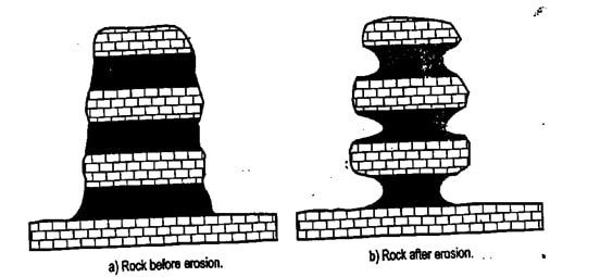
- Give the name of this feature.
- Describe how this feature is formed.
- Give atleast five characteristics of Transverse dunes.
- State five significance of Desert landforms .
-

MARKING SCHEME
-
- What is solar system?
It refers to the sun, the planet and the other heavenly bodies such as asteroids, comets satellites, meteors and meteorites. (2mks) - Name two dwarf planets.
- Pluto
- Eris
- Haumea
- Ceres
- What is solar system?
-
- State five characteristics of the sun.
- It is a star.
- It produces light of its own.
- It is formed of very hot gases, mainly hydrogen and lithium.
- It has very high temperatures.
- It has very high temperatures.
- It is the largest member of the solar system.
- It radiates solar energy to other members of the solar system. (any 5 = 5mks)
- State five characteristics of the sun.
-
- Give three reasons why temperature decreases with increasing latitude.
- At the equator sun rays strike the surface of the earth at right angles and at the higher attitudes at acute angles.
- At the equators, the surface exposed to the sun rays is small while at the higher latitudes it is larger.
- Sun rays cover a long distance before they reach the earth’s surface at higher latitudes thus losing a lot of heat while at the equator the distance covered is short leading to low amount of heat. (3x1 = 3mks)
- Describe the following types of fog:
- Radiation fog.
-Formed at night, when the ground loss heat through terrestrial radiation.
-The air in contact with the cool ground is cooled to form dense fog. (any 1 = 1mk) - Advection fog
Formed by warm moist air moving horizontally over a cooler land or sea surface.
When the air is cooler to its dew point, it forms advection fog. (any 1 x 1 = 1mk0
- Radiation fog.
- Give three reasons why temperature decreases with increasing latitude.
-
- Name the features marked A and B.
A – Pyramid Peak
B- Arete - Describe the formation of the feature marked K.
- Clique is a semi – circular hollow on glaciated slopes of high glaciated mountains.
- It is formed when snow- accumulates in a shallow pre- existing depression on a mountain slope.
- The snow gets compacted into ice to form circus glacier .
- Freeze than action erodes the depression and enlarges it.
- Plucking erodes the sides of the depression widening it and making its sides steeper.
- Abrasion at the bottom deepens the depression.
- Eventually, a deep arm- chair shaped depression known is a cirque is formed.
- When this depression is filled up with melt water it forms a cirri lake or a tarn.
(any underlined word 3x1 = 3mks)
- Name the features marked A and B.
-
- Give the difference between glacial till deposits and flurio- glacier deposit.
Glacial till deposits are moraines deposited by ice. (1mk)
Flurio –glaciated deposits are materials deposited by melt water. (1mk) - Give three characteristics of the tides shown in the diagram below;
- Neap tide is a position where the sun, the earth and the moon form a night angle with the earth at the apex.- The position is known as
- The sun and the moon exert a strong gravitational force on the earth in opposite
- This results in high tides being lower than
- Low tides are higher than normal . (any 3 underlined points 3 x 1 = 3mks)
- Give the difference between glacial till deposits and flurio- glacier deposit.
-
-
- Convert the map scale 1: 50,000 to statement school.
- Convert 50,000 cm into km. ( ½ mk)
- 100,000 cm = 1km ( ½ mk)
- Therefore 50,000 cm = = ½ km 0r 0.5 km.
- Hence the new statement scale is
1 cm represents 0.5 km. 1mk
(Every step earns ½ tick of full tick as shown = 3mks)
- Find the bearing of Mwasungia 903 at grid reference 3922 from Mwasere at grid reference 3826.
The bearing is 1700. (2mks)
- Convert the map scale 1: 50,000 to statement school.
- Measure the distance of the loose surface road from the function (232142) to mission girls
Secondary school (243187) in km.
The distance is 5km 850 meters 1 (1mk)
Hence 5. 85 km
Or 5. 95 km
Or 5.75 km
(Any 1) - Draw a cross section between Kishamba (291) and shops near majengo (3617) On your cross section, show the following :
- Mwachawaza
- Majengo
- Citing evidence, state three reasons why there is dense settlement in their western part of the map.
- Good transport network available as evidenced by dry weather road from farmers training centre (2721) to shops at 2024) provide transportation of their goods and services easily. (1mk)
-Presence of perennial streams evidenced by piringo and noorgosi which provide water for domestic consumption. (1mk)
Forest vegetation as evidenced by Wangaruni forest is a likely indication of high and reliable rainfall and fertile soils suitable for arable subsistence farming that enable sufficient supply of food to people.
(Underlined words a must. 1 mk evidence, 1mk reasons. 6mks) - Give four possible reason that have enabled a commercial farming activity located in the southern part of the map.
- Gentle sloping landscape indicated by spaced contours facilitate mechanization of farms.
- Low settlement of people hence no much compensation cost.
- All weather road available for easy transportation of sisal.
- Settlement (nucleated) at mwalunge provide labour required on sisal farms. (1x4 = 4mks)
-
-
- What is earth movement?
This refers to movements of crystal rocks caused by tectonic forces originating and operating in the interior of the earth.
(any 2 underlined points = 2mks) - Explain how the following activities cause earth movements:
- Magma movement.
- The rocks within the crust and mantle get hot and melt.
- The liquid rock (magma) may flow forcefully (intrude) into the earth’s crust.
- Intrusion of magma forces the rock to move and their places taken over by the intruding Hence causing earth movement.
(underlined words must be mentioned for 2 maximum pts. ) - Gravitation force.
The attractive force that pulls all bodies towards the centre of the earth tends to pull the rocks towards the centre of the earth to fill hollows left by the magma flowing towards the surface of the earth hence causing earth movement. - Convectional currents.
- The convectional currents within the molten rock in the mantle are in circular motions from the mantle towards the crustal rocks.
- As they move, they exert a frictional drag with the Sima rock causing crystal rocks to move horizontally hence causing earth movements. (underlined words 2mks)
- Isostatic adjustment.Isosstacy is the state of balance exiting between the lighter upper crust SIAL and the denser inner region (SIMA) of the earth. This balance must be maintained at all times. Any disturbance caused by other movements disrupt the balance hence leading to isostatic adjustment. (2mks)
- Magma movement.
-
- Describe Alfred Wegeners Continental drift theory.
- That there once existed a super continent called Pangea in the carboniferous period.
-It was surrounded by a large super ocean called Panthalasa
- That due to different gravitational forces Pangea broke –up into two large continents called Grandivanaland to the south and Laurasia to the north in the Mesozoic period.
- That the two were separated by a long narrow ocean known as Tethys.
- That Gandwanaland and Laurasia further nyptured and drifted apart forming the present six continents of the world. (6mks)
(insist on underlined words to give full mks) - Give atleast two characteristics of each of the following boundaries.
- Extension boundaries
These are zones where two plates move away from one another due to convectional currents.
A new crust is created at the boundary to form extension boundary or constructive margin. (any underlined = 2mks) - Compression boundaries
These are zones where plates move towards each other.
This leads to destruction of plates along their margins leading to destructive margins or seduction zones. (Underlined points 2mks) - Transform faults
The conventional currents for two adjacent plates separate by a major fault called transform fault slide past each other.
The crust in this case is conserved (neither created nor destroyed) hence conservative margin. (2 underlined 2mks)
- Extension boundaries
- Name at least three large plates.
- Eurasian plate
- Australian plate
- African plate
- Antarctic plate
- North America plate
- Pacific plate. (3mks)
- Describe Alfred Wegeners Continental drift theory.
- What is earth movement?
-
-
- What is folding ?
It refers to the bending of rocks of the earth’s crust due to earth’s movement.(1mk) - Distinguish between foreland and backland.
Foreland is relatively static block of land during the formation of blocks mountains by compressional forces.
Backland is the source region of compressional forces during the formation of block mountains by compressional forces.
(Underlined words a must = 2mks) - Use a well labeled diagrams to describe the formation of Atlas and alpine mountains.
Stage 1
In the Mediterranean region, Africa was the backland while Europe was the foreland.
Stage 2
The geosynclines is filled with water and sediments eroded by rivers.
(Explanation = 2mks)
(Diagrams 2 x 3 = 6mks)
Stage 3
Forces from Africa caused sediments in the geosynclines to fold leading to formation of Atlas mountains closer to the backland and alphine mountains near the foreland.
- What is folding ?
- Give a diagrammatic illustration of the difference between a normal fault and a reversal fault and a reserved fault.
- Students of Mtongwe sec. school undertook a filed study of folded landscape in Malindi.
- Design a work schedule for them study.
7:30 – 8:00 - assemble in the geography room and counter check the required equipment.
8:00- 9:00 - travel from the school to the field of study.
9:00 – 10:00 - am a brief introduction and instructions given by relevant authorities.
10:00 – 1:00pm - formation of group and taking different directions to study land form.
1:00 – 2:00 pm – compiling reports as they take their light packed lunch.
2:00 – 3:30pm travel back to school.
(Any 4 well explained = 4mks) - State two null hypothesis they designed for the study.
The general topography along the coast is not comprising of folded landscape.
Folded landscape along the coast has disabled settlement along the coastal plains completely. ( any other 2 = 2 x 1= 2)
- Design a work schedule for them study.
- Explain two negative significance of folding to human activities.
Folding mountaineous regions lead to descending and ascending winds with economic significance e.g fohn winds in the Alphine ranges cause destruction of vineyards. (2mks)
Folding processes lead to crustal cracks which contribute to vulcanism which leads to destruction of human property and deaths of human resources. (2mks)
Folding has also led to the burying of some valuable minerals such that they are not easily accessible for exploitation. (2mks)
(any 2 point = 4mks)
-
-
-
- What is a wave?
Waves are oscillations of water particles caused by the wind blowing across the water. (2mks) - Give at least three characteristics of the following waves.
- Constructive waves.
There are weak and infrequent waves.
Their swash is more powerful than back wash.
They deposit materials at the shore to form depositional features like beaches.
They are common on the shallow gently sloping coasts. (any 3 x 1= 3mks) - Destructive waves
Destructive waves are strong and more frequent.
Their back wash is strong than swash.
Destructive waves erode the shore to form erosion features.
They are common on steep sloping coasts. (any 3 x 1= 3mks)
- Constructive waves.
- Explain atleast four factors influencing transportation of materials along the coast.
- Strength of wave (1mk)
Strong waves carry heavy and large quantities of materials over long distances. Weak waves carry light and few material over short ditsnaces. - Tides (1mk)
During high tides materials are moved from the sea to the beaches or land. - Ocean currents. (1mk)
An ocean current carries materials from one part of the ocean to another to the beach. (1mk) - Gradient of the shore. (1mk0
Gently sloping coasts encourage the movement of materials along the coast compared to steep slopes. (1mk) - Alignment of the coastline. (1mk)
Coast which are aligned obliquely to the direction of the breaking waves allow for transportation of materials through longshore drift. (1mk) - Nature of the load. (1mk)
Light materials are transported through suspension. Heavy materials roll down on the shore following direction of wave. Soluble materisla are transported through solution. (1mk0
N/B Approach very important. Mention the factors, explain it to get a full mark. Strictly 8mks)
- Strength of wave (1mk)
- What is a wave?
- State how the following factors determine the type of coasts.
- Wave and tidal current.
- Strong back wash compared to swash and tidal currents erode the coast forming erosional features. (1mk)
- Strong swash compared to backwash and weak tidal currents lead to deposition of carried materials forming depositional features. (1mk)
- Slopes of the coast.
- Wave erosion is greater on steep slopes. (1mk)
- Wave deposition is dominant on gentle slopes. (1mk00
- You are planning to carry out a field study on coastal landforms.
- List two methods you would use to collect datea.
- Observing landforms.
- Taking photographs.
- Collecting samples
- Reading from already recorded information
- Taking measurements
- Taping or filming.
- Counting
- Feeling and touching. ( any 2 x 1 = 2mks)
- Give three reasons why it is necessary for reconnaissance.
- To design the appropriate research method.
- To prepare the work schedule.
- To be able to formulate the appropriate objectives and hypothesis.
- To be able to identify relevant equipement for data collection.
- To identify suitable areas for studying. (any other suitable point. 1 x 3 = 2mks)
-
-
-
- Define Qrid lands.
Areas which receive insufficient or low rainfall and have little vegetation.
( underlined pls a must = 2mks) - List at least two of the following deserts.
- Hot deserts:
- Sahara desert
- Kalahari desert
- Namib desert.
- Cold desert
- Antarctica desert
- Patagonia desert
- Define Qrid lands.
-
- Give the name of this feature.
- Rock pedestal - Describe how this feature is formed .
- This is an irregular pillar of rocks formed by wind abrasion.
- It is formed where the rock mass consists of alternative layers of hard and soft rocks.
- The layers lie horizontally and in the patty of wind.
- The rock mass is eroded by abrasion. The soft layers are worn away faster than the hard layers.
- There is greater erosion wear the ground by abrasion.
- This gives the rock pedestals an irregular shape with protruding layers that alternate with hollows.
- An example of a rock pedestal is Devil’s rock in Niger.
- Rock pedestals are common in central Sahara and in Saudi Arabia.
(any 4 well described pls. x 3= 8mks)
- Give the name of this feature.
- Give five characteristics of transverse dunes.
- They are long waves – like sand dune, ridges, which are separated from each other by troughs.
- They form where light moderate wind blows from one direction on a sandy desert for a long period.
- They lie at right angles to the prevailing winds.
- They occur in groups.
- They have an average height of 50 m.
( any underlined word gives a maximum mark.)
- State five significance of desert landforms.
- less regions have fertile soils which are used fro crop cultivation. (1mk)
- Features such as gorges, sand dunes and rock pedestals attract tourists who bring foreign exchange thus improving peoples living standards . (1mk)
- Extensive and bare deserts surfaces are used as testing ground for jet engineers and cars. (1mk)
- Some deflation hollows contain water which is used for domestic purpose. (1mk)
-Desert landscape provides ideal sites for testing military weapons or nuclear bombs.(1mk)
-Salty flats and Salinas are used for salt production for domestic use. (1mk)
-Desert areas provide suitable scenery for film making. (1mk)
(Any 5 well stated = 5mks)
-
Join our whatsapp group for latest updates
Tap Here to Download for 50/-
Get on WhatsApp for 50/-
Download GEOGRAPHY PAPER 1 - KCSE 2019 MOCK EXAMINATION - KAKAMEGA.
Tap Here to Download for 50/-
Get on WhatsApp for 50/-
Why download?
- ✔ To read offline at any time.
- ✔ To Print at your convenience
- ✔ Share Easily with Friends / Students


