
SECTION A:
Answer ALL questions in this section
- Define mining. (2marks)
- Statethree factors influencing the occurrence of minerals. (3marks)
- Statethree advantages of Hydro-electric power in Kenya. (3marks)
- Give two measures of conservation energy. (2marks)
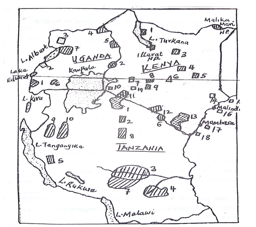
(a) Study the map blow of East Africa and use it to answer questions. Name;
- The National Park marked 2. (1mk)
- The Game Reserve marked 4. (1mk)
- The game sanctuary marked 7. (1mk)
(b) State three reasons why Switzerland receives more tourists than Kenya. (3marks)
- Identify four factors which have contributed to the growth of Mombasa as an international port. (4marks)
- Outline the stages of reclamation of land from the sea in the Netherlands through the Zuider Zee project.(5marks)
SECTION B
Answer question 6 and any othertwoquestions from this section.
- (a). The table below shows maize production in Kenya per county; between 2017 – 2018 in `000 kgs.
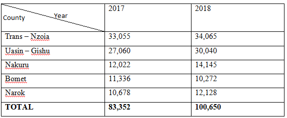
- Using a scale of 1cm to represent 10million kgs,draw a divided rectangle to represent thedata for maize production in 2018. (6marks)
- Describe the production of maize in the 5 counties in Kenya.(4marks)
- Statethree disadvantage of using a divided rectangle to represent the above data. (3marks)
(b). State three physical conditions that favour maize growing in Kenya. (3marks)
(c). Givethree problems facing maize farmers in Kenya. (3marks)
(d). Explainthree ways in which the government of Kenya can assist maize
farmers in Kenya. (6marks)
- (a) State four physical factors thatfavored the establishment of Ruhr Industrial region in Germany. (4marks)
(b). Explainfour problems arising from industrialization in Kenya. (8marks)
(c). Statefive characteristics of cottage industry in India. (5marks)
(d) Formfour students in your school carried a field study on Thika town.
(i). Give four factors that led to growth of Thika as an industrial centre. (4marks)
(ii). Givefour advantages of studying industry through field work. (4marks)
- Study the map of the world below and use it to answer question (a) (i)
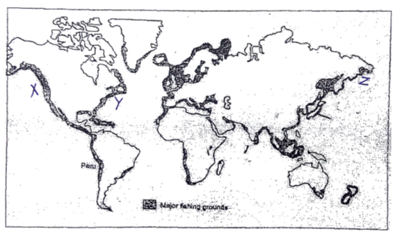
(a). (i). Name the fishing grounds marked. (3marks)
X -
Y -
Z -
(ii). Explainthree physical factors influencing fishing in the region marked X on the map. (6marks)
(b) Describe how the basket method is used in catching the fish. (5marks)
(c) (i) State five ways in which marine fisheries in Kenya can be conserved. (5marks)
(ii) Name three methods used to preserve fish in lake Turkana. (3marks)
(d) State three characteristics of demersal fish. (3marks)
- (a) Study the map outline below shows the Great lakes and St. Lawrence sea way and use it to answer questions below.
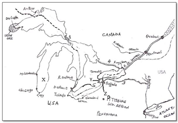
- Use the map to name the following: (4marks)
- The lake marked X
- The canal marked Y
- The waterfall marked Z
- Statefive problems and the solutions faced during the construction of the Great lakes and St. Lawrence sea way. (5marks)
- Explainthree ways through which the water way has promoted industrialization in the economies of the Canada and U.S.A. (6marks)
(b). State four ways in which the Kenyan government has promoted air transport. (4marks)
(c). What is containerization? (2marks)
(d). Givefour advantages of the Great North road. (4marks)
- Differentiate between management and conservation of environment. (2marks)
- State four reasons for the management and conservation of environment. (4marks)
- Givethreeman-made hazards in your country. (3marks)
- Statefiveeffects of drought in Kenya. (5marks)
- You are planning to carry out a field study on causes of pollution along Nairobi river.
- Identifythree ways you will need to prepare for the study. (3marks)
- Identify five causes of pollution you are likely to see along Nairobi river. (5marks)
- What are possible follow-up activities that students will be involved in after the study? (3marks)

MARKING SCHEME
SECTION A: 25 MARKS
- Define mining?(2marks)
The process of extracting valuable minerals from the earth’s crust /on the earth’s surface - State three factors influencing the occurrence of minerals. (3 marks)
- Through vulcanicity
- Through weathering
- Through deposition
- Through evaporation
- Through sedimentation
- Through metamorphism
- Through erosion
- Define mining?(2marks)
- State three advantages of hydro-electric power in Kenya (3 marks)
- Its renewable /non-exhaustible
- Its clean to use /non pollutant
- Relatively cheap to generate compared to nuclear
- Easy to transport using wires over long distances
- Easy to use by switching on and off
- It can be adjusted to any fraction of energy required for use
- Construction of HEP stations /dams leads to formation of lakes used for irrigation
- HEP is versatile/can be put to many uses like cooking /lighting/cooling
- Give two measures of conserving energy in Kenya. (2marks)
- Encouraging afforestation /re-afforestation for continued supply of wood fuel
- Encouraging people to use renewable energy sources to reduce over reliance on fossil fuels
- Developing energy saving technologies /devices so as to reduce high consumption of energy
- Enforcing legislations against indiscriminate cutting of trees for fuels
- Educating the public on the careful use of energy to prevent wastage
- Proper planning of the road networks and proper maintenance of road conditions to reduce traffic congestion hence saves on fuel consumption
- Discouraging the importation of high fuel consuming vehicles to reduce the amount of fuel used
- State three advantages of hydro-electric power in Kenya (3 marks)
- Study the map of East Africa below and use it to answer question 3 (a).
Name;
- The National park marked P
- The Game reserve marked Q
- The Game sanctuary marked R
(b) Give three reasons why Switzerland receives more tourists than Kenya. (3marks)
- Switzerland is centrally located in Europe thus easily accessible to most tourists while in Kenya is far away from Europe.
- The political policy of neutrality and peaceful atmosphere in Switzerland encourages tourists while in Kenya the tribal clashes /terrorist’s attacks /insecurity scare away tourists.
- Some tourists’ attractions are similar hence tourist prefer to visit those nearer home.
- Well-developed transport network in Switzerland encourages tourists as opposed to Kenya where the roads are poorly maintained.
- Switzerland has fair charges for tourist services while in Kenya accommodation and park charges are high discouraging many tourists.
- Many well developed and efficient financial institutions in Switzerland attract tourists on business while in Kenya there are few and less developed financial institutions.
- Switzerland has double seasons that enable tourists’ activities throughout the year while in Kenya there is only one peak season with many tourists.
- Switzerland is the headquarters of many international organizations and agencies attracting many tourists for international meeting while in Kenya the headquarters of UNEP has few official meetings.
- Highly trained personnel in the hotel industry in Switzerland, hospitable and efficient hence more tourists while in Kenya there are few trained and high-class hotels hence few tourists.
- Inadequate alternative sources of energy that can fit the position of oil cause of over reliance on oil and oil products.
- Improvement in technology resulting into many machines that consume a lot of energy leading to shortage hence causing crisis.
- Limited oil reserves which are being exploited are controlled by a few countries.
- Prolonged drought which lowers production of HEP as a result of less water hence calling for more demand on petroleum.
- Artificial shortages may be created by oil producing countries by withholding the oil.
- Rapid depletion of oil reserves.
- Identify four factors which have contributed to the growth of Mombasa as an international seaport. (4marks)
- Farms are generally small in size.
- A deep and well sheltered harbor.
- Modern port facilities for handling of goods.
- A large and rich hinter land.
- Well linked to the main land by air, road and railway.
- Strategic location hence accessible by ship by ship from Europe, Asia.
- Presence of many tourist attractions.
- Outline the stages of reclaiming of land from the sea in the Netherlands through the Zuider Zee project. (5 marks)
- The part of the low-lying land and covered by the sea water is enclosed by strong /protective walls called dykes.
- Ring canals are constructed to lead the water to the pumping stations.
- Water is pump out using the wind mills /electric pumps/diesel pumps.
- Ditches are constructed/dug to drain the excess water out of the enclosed land.
- Reeds are planted /sown to suck up the excess water and reduce salinity.
- Chemicals are added to the soil to reduce salinity/fresh water is pumped into the enclosed land.
- Oats /sugar beets/rye are planted to improve the soil pH and reduce water further
- The dry land is ready for use.
- Outline the stages of reclaiming of land from the sea in the Netherlands through the Zuider Zee project. (5 marks)
SECTION B
Answer question 6 and any other TWO questions from this section.
- Table below shows the maize production in Kenya per county between 2017 and 2018 in 000 kgs.
|
YEAR/Country |
2017 |
2018 |
|
Trans -Nzoia |
33055 |
34065 |
|
Uasin -Gishu |
27060 |
30040 |
|
Nakuru |
12022 |
14145 |
|
Bomet |
11336 |
10272 |
|
Narok |
10678 |
12128 |
|
Total |
83352 |
100650 |
Source: Kenya Economic Survey, 2010
- Use the table to draw a divided rectangle 10 cm to represent the amount of maize productionin2018. (6 marks)
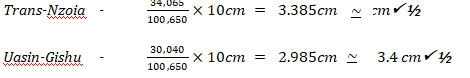
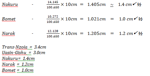
- Describe the trend in the production of maize in the five counties in Kenya. (3marks)
- Trans -Nzoia county is the leading maize producing county in in Kenya
- There was significant increase in the total maize production in all the three counties
- Narok county is the least maize producing county among the five counties
- Bometcounty dropped in the amount of maize production between 2017 and 2018.
- Use the table to draw a divided rectangle 10 cm to represent the amount of maize productionin2018. (6 marks)
- State three physical conditions required for the growing of maize in Kenya. (3 marks)
- Temperatures ranging 10-30 °C /Moderate to high temperatures/hot conditions
- Moderate to high rain rainfall throughout the year/800-1800mm
- There should be a dry period for the maize to ripe/dry properly
- Well distributed rainfall throughout the year
- Gently sloping landscape/undulating landscape
- Deep, well drained volcanic soils /loam soils
- Explain four problems facing maize farming in Kenya. (8 marks)
- The crop is attacked by pests i.e. weevils/birds/aphids/army worms/stalk-borer lowering yields and quality
- The crop is attacked by diseases i.e. white leaf blight/lowering yields and quality.
- The crop is affected by fluctuations in world market prices, reducing income to the farmer and revenue to the government.
- Some maize growing areas have poor /impassable roads, during the rainy seasons which affect the production/delivery of the harvest.
- Maize production is sometimes affected by inadequate rainfall/drought, reducing production and income to the farmers.
- High cost of farm in puts prices which reduce farmers’ income leading to low standard of living.
- Delayed payments to farmers reduce their morale/demoralizing the farmers.
- Poor storage facilities /silos thus the produce is destroyed by the weevils reducing their income.
- Give fiveways in which the government can assist maize farmers in Kenya. (5 marks)
- The government of Kenya allocates funds through the National cereals and produce board /NCPB to buy maize from the farmers at fair prices on time to encourage them
- The government restricts /discourage the importation of maize to reduce competition in the local markets
- The government gives credit facilities /loans through the Agricultural finance corporation to the farmers to expand maize farming
- The government through Kenya Agricultural Research Institute and other research agencies develop high quality, resistant and high yielding hybrid seeds for maximum production
- The government can subsidize on the fertilizers, seeds and other farm inputs to reduce the cost of production thus increasing the farmers profit margins
- State four physical factors that favoured the establishment of Ruhr Industrial region in Germany. (4 marks)
- Availability of coal, iron ore and limestone from the Rhine valley.
- Availability of water from river Rhine, Ruhr, Lippe, Emscher and Wupper.
- Presence of the navigable rivers Rhine, Ruhr.
- Availability of coal from the Ruhr region.
- Explain four problems arising from industrialization in Kenya. (8 marks)
- Industrialization has led to rural-urban migration which has increased the urban population leading to congestion/shortage of houses/increase in crime.
- Some industries emit toxic gases which are harmful to people/wildlife.
- Industrial effluents pollute water resources making them unfit for use by man/animal consumption.
- Industries emit fumes which corrode metallic roofs of buildings hence destroy them.
- Concentration of social services and infrastructures such as roads in the industrial centres leading to an imbalance of economic development.
- Careless dumping of industrial wastes has led to land degradation.
- Some industries have led to displacement of people thus leading to disruption of normal life, social and economic.
- Imbalance of regional development since most industries in urban centres.
- Reduction of job opportunities and industries which tend to use technological innovations that are efficient.
- State five characteristics of cottage industry in India. (5 marks)
- Requires little capital to set up / run.
- Uses simple equipment /machines
- Different establishments are owned by individuals/families.
- Uses locally available raw materials.
- Products are mainly for local markets.
- Industrial establishments are widespread in the country/located in homes.
- Labour is provided by members of the family/industrial owners.
- Craft men are highly skilled.
- Form Four students in your school carried out a field study on Thika town.
- Give four factors that led to growth of Thika as an industrial centre. (4 marks)
- Abundant water supply from river Chania.
- Well-developed roads and rail transport.
- High population around Thika.
- Rich agricultural hinterland that produces raw-materials for industries.
- Government policy of industrial decentralization.
- The expansive flat land for setting up the industries.
- Give four factors that led to growth of Thika as an industrial centre. (4 marks)
- Give four advantages of studying industry through field work. (4 marks)
- Provides first-hand information on facts and concepts about industries.
- Students are able to relate/apply knowledge gained to real situations.
- Helps in the development of skills/application of skills.
- Enable students to acquire appropriate attitudes towards the environment.
- Breaks the classroom monotony for students and teachers.
- Enables visual memory of industry better than theory.
- Provides in-depth/broader-learning.
- State four physical factors that favoured the establishment of Ruhr Industrial region in Germany. (4 marks)
- The map below shows one of the fishing grounds in the World. Use it to answer the questions that follow.
- Identify the fishing grounds marked X and Y. (2 marks)
X- North East Atlantic
Y- North West Pacific - Explain three physical factors favouring fishing in the above-namedZ fishing ground. (6 marks)
- Indented coastline provide secure fish breeding grounds because the boys sheltered from sea waves.
- Has several fiords suitable for the building of fishing ports/fish landing sites.
- The warm North Pacific current makes the water ice free therefore fishing is carried out throughout the year.
- Rugged landscape adjacent to the coast discourage agriculture therefore people resort to fishing as an alternative economic activity.
- The ocean currents of warm and cold meeting causes up welling of water which bring minerals to the surface for the planktons which are fish food.
- The broad and shallow continental shelf provide suitable conditions for growth of planktons which is fish food.
- Describe basket method of fishing (6marks)
- The basket is funnel shaped to allow easy entry of fish
- At the mouth of the basket is a non-return valve which restricts the outward escape /movement of fish once inside the basket
- The basket is lowered in shallow waters with the mouth facing the direction from which the water is flowing
- The basket is held in position by ropes and stones to prevent it from being swept away by water
- A bait is put inside the basket to attract fish
- The basket is left in that position overnight
- In the morning the basket is brought to the surface where the fish is removed
- Identify the fishing grounds marked X and Y. (2 marks)
- State five ways in which the government should conserve fisheries. (5 marks)
- Restocking of overfished waters by breeding fingerlings in the fish farms and releasing them to the fisheries.
- Use of standard sized nets to ensure that only mature fish are caught.
- Restricting the disposal of untreated wastes into fisheries to avoid pollution.
- Monitoring /discouraging the entry of foreign fishermen off the Indian Ocean waters.
- Enforcing international conventions to protect endangered fish species.
- Restricting fishing to specific seasons to allow breeding and maturing of fish.
- Licensing fishermen to control their number thus prevent overfishing.
- Name three methods used to preserve fish in Lake Turkana. (3marks)
- Salting
- Sun drying
- Smoking
- Refrigeration
- Freezing
- Canning
- State three characteristics of demersal fish (3marks)
- Found near at the bottom of the sea
- Are large in size
- Live singly
- Are non-migratory in nature
- Feed on small fish
- State five ways in which the government should conserve fisheries. (5 marks)
- The map below shows one of the fishing grounds in the World. Use it to answer the questions that follow.
- The sketch map below shows Great Lakes and St. Lawrence Seaway. Use it to answer question (a).
- Name:
- the lake marked (1 mark)
Lake Michigan. - the canal marked (1 mark)
The Soo canal. - the port marked (1 mark)
Duluth. - Give five problems and their solutions faced during the construction of the Great lakes and the St. Lawrence seaway (5marks)
- Presence of rock outcrops in the river channel which were blasted for smooth navigation of ship
- Presence of waterfalls and rapids in the river channel which were by passed by the construction of several canals to join lakes
- The freezing of water in the river channels during winter was blasted by ice breakers
- Presence of fog causing visibility problem that was solve by installing of radars and lights for ship to use
- The narrow and shallow sections of the rivers was solved by dredging to deepen the shallow sections
- The low level of waters in the sections of lakes was solved by the construction of locks and computerized gates to regulate water levels /construction of dams /reservoirs to control water flows.
- Explain three ways through which the water way has promoted industrialization in the economies of Canada and USA. (5marks)
- It has increased trade both internal and external.
- Has facilitated the movement of raw materials and finished products.
- Has reduced the coast of transport of bulky products.
- The dams along the water way provides HEP for industrial use.
- It has led to the development of lake ports and towns which provide. market /labour/housing facilities.
- The reservoirs provide water for industrial use.
- the lake marked (1 mark)
- State four ways in which the Kenya government has promoted air transport (5marks)
- Expansion and construction of new airports like JKIA/EIA/KIA to handle more goods and the passengers.
- Liberalization of the air transport industry by allowing different airlines to venture into the industry such as Air Kenya, Safari Link. This will improve service delivery and encourage competition.
- Supporting Kenya airways to buy new air crafts with large carrying capacity e.g . Boeing 777,Boeing 787,Dream Liner.
- By upgrading and maintaining roads leading to the international airports
- Installing modern navigational equipment to increase surveillance to improve on security.
- Training more personnel in modern aviation technology/hiring trained personnel to improve service delivery.
- Promoting budget flight /package tours to lower the cost of travel/lower operation cost.
- What is containerization (2 marks)
This is the packaging of goods in large standard size rectangular metallic structures in the factory sealed and transported to the consumers either by water, rail or road. - Give four advantages of the Great North road.(4 marks)
- It’s a faster means compared to water
- Easy and relatively cheaper to construct compared to railway and air transport
- Its flexible as it offers door to door services/there are various types of roads
- Many types of vehicles can use roads whereas trains of specific designs use rail tracks
- Roads carry small quantities of load thus promoting small scale businesses
- Differentiate between management and conservation of environment. (2 marks)
Management of environment refers to the measures and controls directed at the exploitation/utilization and improvement of physical environment for posterity while;
Conservation of environment is the protection and preservation from destruction, waste/loss of natural resources through careful use. - State four reasons for the management and conservation of environment. (4 marks)
- For scientific research /education.
- To keep the air clean/purify the air.
- To prevent desertification.
- To modify local climate.
- To protect water catchment areas.
- Natural resources are protected for posterity/future generation.
- For aesthetic value/beauty for recreation.
- To protect some endangered plants/animals species from extinction.
- To sustain supply of raw-materials for industries.
- To provide habitat for wildlife.
- To maintain source of food supply.
- To ensure sustainable utilization of resources.
- To provide materials for medicinal extract.
- Give three man-made hazards in your country. (3 marks)
- Fires
- Pollution/land/water/air/sound
- Soil erosion
- Mono culture/overgrazing/over cropping
- Deforestation
- Over population
- State effects of drought in Kenya. (5 marks)
- Depletion of national food reserves hence food shortages/famine.
- Massive importation of food leads to limited economic growth.
- Death of livestock.
- Death of livestock.
- Drying up of rivers/shortage of pastures.
- Migration of people and livestock to sustainable areas.
- Identify causes of pollution along Nairobi River. (5 marks)
- Oil lakes from trucks/pipelines
- Industrial effluents when discharged into River Nairobi.
- Washing away chemicals/fertilizers/pesticides/insecticides from farmlands.
- Dumping of solid wastes into the river.
- Disposing of raw sewage into rivers.
- Surface run-off/soil erosion into water bodies.
- State effects of drought in Kenya. (5 marks)
- You are planning to carry out a field study on causes of pollution along Nairobi river. Identify three ways you’ll need to prepare for the study. (3 marks)
- Seeking permission from relevant authorities.
- Conducting a reconnaissance/pre-visit.
- Holding discussions in class.
- Preparing a questionnaire.
- Organize students into groups.
- Preparing necessary documents.
- Reading through relevant literatures.
- Preparing a working schedule.
- Selection of important tools.
- What are possible follow-up activities that students will be involved in after the study? (3 marks)
- Reading more on the topic.
- Display photographs/items collected.
- Draw diagrams.
- Write reports/presenting reports.
- Discuss with the rest of the class.
- Analyze/assess the information collected against the hypothesis.
- Model of the area of study.
- Confirming/rejecting of the hypothesis based on the findings.
- Differentiate between management and conservation of environment. (2 marks)
Download GEOGRAPHY PAPER 2 - 2019 MOKASA II MOCK EXAMINATION.
Tap Here to Download for 50/-
Get on WhatsApp for 50/-
Why download?
- ✔ To read offline at any time.
- ✔ To Print at your convenience
- ✔ Share Easily with Friends / Students


