
INSTRUCTIONS TO STUDENTS
- This paper has two sections A and B
- Answer ALL the questions in section A. In section B answer questions 6 and any other TWO
SECTION A
Answer all the questions in this section.
- What is practical Geography? (2 marks)
- State three practical aspect we study in Geography. (3 marks)
- Apart from marine parks, give two other tourist attractions at the Kenyan coast. (2 marks)
- State three reasons why national parks have been established in Kenya. (3 marks)
- Name two towns in Kenya where motor vehicle assembly plants are found. (2 marks)
- State three ways in which Kenya has benefited from assembling of motor vehicles locally. (3 marks)
- Identify two indigenous beef cattle breeds raised in Kenya. (2 marks)
- Give three factors which favour beef farming in the Nyika plateau. (3 marks)
- Differentiate between exports and imports. (2 marks)
- State three factors which influence external trade in Kenya. (3 marks)
SECTION B
Answer question 6 and any other TWO questions from this section.
- Study the photograph below and use it to answer question (a).
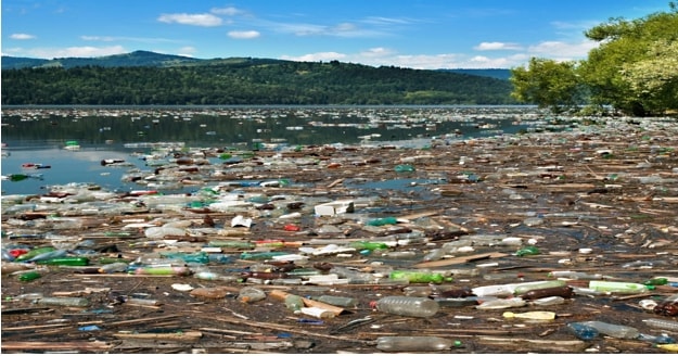
- What evidence in the photograph shows that this is a ground general view type of photograph? (2 marks)
- Name the type of pollution shown on the photograph. (1 mark)
- Draw a rectangle measuring 15cm by 10cm to represent the area on the photograph. On it, sketch and label the main features shown on the photograph.(5 marks)
- State three causes of this type of pollution. (3 marks)
- Explain three measures that may be taken to combat this type of pollution. (6 marks)
- Name two rivers in Kenya to the west of the rift valley which cause large scale flooding. (2 marks)
- Explain factors that lead to frequent flooding in the lake region of Kenya.(6 marks)
-
-
- Define the term fisheries. (2 marks)
- Name two types of inland fisheries in East Africa. (2 marks)
- State four measures that the government of Kenya has taken to conserve fisheries. (4 marks)
- Describe how basket fishing method is used to catch fish. (6 marks)
- The following map shows the world distribution of the major fishing grounds. Study and use it to answer the questions that follow.
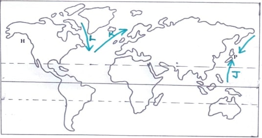
- Name two types of fish species found in the fishing ground marked P.(2 marks)
- Identify the ocean currents labelled J, K and L. (3 marks)
- Explain three physical factors that favour large scale fishing in the fishing ground marked H. (6 marks)
-
-
-
- Identify the type of energy from the following sources of energy.
- Tides (1 mark)
- Uranium (1 mark)
- What is Geothermal energy? (2 marks)
- State three factors that hinder expansion of geothermal production in Kenya. (3 marks)
- Identify the type of energy from the following sources of energy.
- Explain three problems that face the use of firewood as a source of energy in Kenya. (6 marks)
-
- State four physical factors that favoured the location of the Owen Falls Hydro-electric Power project in Uganda. (4 marks)
- Explain two problems the government of Kenya faces in her effort to develop H. E. P stations. (4 marks)
- Form Four students carried out a field study in Kamburu H.E.P plant.
- State two objectives for their study. (2 marks)
- Give two reasons why they needed a working schedule. (2 marks)
-
-
- Differentiate between transport and communication? (2 marks)
- Explain how the following factors influence development of transport in Kenya.
- Government policy (2 marks)
- Relief (2 marks)
-
- Identify three conditions of roads in Kenya that cause occurrence of accidents. (3 marks)
- State three measures taken by the government of Kenya to reduce road accidents. (3 marks)
-
- Name two major railway lines in East Africa. (2 marks)
- State three reasons why road transport is more developed than railway transport in East Africa. (3 marks)
- Study the map of the great lakes and the St, Lawrence Sea way provided and use it to answer the questions that follow.
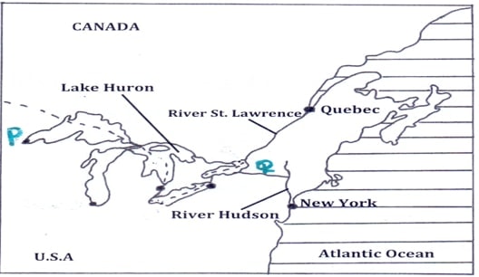
- Name the port mark P and the canal marked Q. (2 marks)
- Explain three ways in which the sea route has contributed to industrial growth in the region. (6 marks)
-
-
- What is population? (2 marks)
- Give three reasons why it is important for the government to conduct a population census. (3 marks)
- Explain how the following physical factors has influenced population distribution in Kenya.
- Climate (2 marks)
- Pests and diseases. (2 marks)
-
- Define the term fertility. (2 marks)
- Give four factors that influence fertility. (4 marks)
- State four causes of intra-urban migration. (4 marks)
- Explain three problems that result from high population growth rate in Kenya. (6 marks)
-
MARKING SCHEME
SECTION A
Answer all the questions in this section.
-
- What is practical Geography? (2 marks)
- The study of practical skills which enhance the understanding and interpretation of geographical phenomena.
- State three practical aspect we study in Geography. (3 marks)
- Maps and map reading/Maps and mapwork
- Photograph work
- Time management
- Data interpretation
- Data presentation
- What is practical Geography? (2 marks)
-
- Apart from marine parks, give two other tourist attractions at the Kenyan coast. (2 marks)
- Sandy beaches/cliffs/caves/Indian ocean
- Coral reefs
- Mangrove swamps
- Marine life
- Warm/sunny climate of the coast
- Historical sites e.g. fort Jesus
- Traditional culture of the people/dances/shrines/Kaya forests/craft
- Water sport/beach sports
- State three reasons why national parks have been established in Kenya. (3 marks)
- To preserve Kenya’s natural beauty.
- To conserve wildlife/flora and fauna
- To attract tourists
- To provide opportunities for education and research
- To protect our wildlife for posterity
- Apart from marine parks, give two other tourist attractions at the Kenyan coast. (2 marks)
-
- Name two towns in Kenya where motor vehicle assembly plants are found. (2 marks)
- Nairobi
- Thika
- Mombasa
- State three ways in which Kenya has benefited from assembling of motor vehicles locally. (3 marks)
- Creation of employment
- Earns Kenya foreign exchange
- Helps Kenya save on foreign exchange.
- Has led to development of skills among Kenyans.
- Enabled Kenya to develop trade links with other neighbours.
- Stimulates development of other related industries e.g. paint
- Led to investment of capital by rich companies.
- Name two towns in Kenya where motor vehicle assembly plants are found. (2 marks)
-
- Identify two indigenous beef cattle breeds raised in Kenya. (2 marks)
- Boran
- Zebu
- Sahiwal
- Give three factors which favour beef farming in the Nyika plateau. (3 marks)
- The presence of watering points/Lorian swamps/some permanent rivers to provide water for animals
- There are large tracts of land/sparsely populated areas with natural grass which provide food for animals.
- The local people keep livestock e.g their occupation provide the basis for beef farming.
- The semi-arid condition/Low Savanna grassland in the region favour beef cattle keeping.
- The area is free from animal pests especially the tsetse flies.
- Gentle slopes/ relatively flat terrain for easier movement of animals
- Identify two indigenous beef cattle breeds raised in Kenya. (2 marks)
-
- Differentiate between exports and imports. (2 marks)
- Exports are goods that a country sells to other countries while imports are good that a country procures from other countries.
- State three factors which influence external trade in Kenya. (3 marks)
- Government policy/services
- Differences/similarities in goods produced
- Availability of aids to trade
- Demand for goods locally
- Availability of transport/communication network
- The purchasing power of the people/ availability of capital.
- The level of industrialization.
- Political stability/relationship of trading partners.
- International trade agreements/restrictions.
- Varying exchange rates
- Differentiate between exports and imports. (2 marks)
SECTION B
Answer question 6 and any other TWO questions from this section.
- Study the photograph below and use it to answer question (a).
- What evidence in the photograph shows that this is a ground general view type of photograph? (2 marks)
- The focus is on many objects
- The photograph captures the broad view of the area
- The objects become progressively smaller towards the back ground
- Name the type of pollution shown on the photograph. (1 mark)
- Water pollution
- Draw a rectangle measuring 15cm by 10cm to represent the area on the photograph. On it, sketch and label the main features shown on the photograph. (5 marks)
- State three causes of this type of pollution. (3 marks)
- Oil leaks from ships/trucks
- Dumping of solid waste into water courses
- Surface run off/soil erosion into water depositing it.
- Disposing of raw sewages into rivers/lakes
- Washing/bathing/watering animals in rivers/lakes
- Washing away into rivers and lakes chemicals/fertilizers/pesticides/ insecticides
- Industrial effluent when discharged into rivers/lakes
- Explain three measures that may be taken to combat this type of pollution. (6 marks)
- Recycling wastes in order to reduce the industrial waste turn over.
- Industrial waste such as effluents should be treated before releasing them to water to reduce their negative impact.
- Biological control of weeds should be encouraged instead of using weed killer chemical
- Enforce environmental laws on the use of improved technology for industrial efficiency.
- What evidence in the photograph shows that this is a ground general view type of photograph? (2 marks)
- Name two rivers in Kenya to the west of the rift valley which cause large scale flooding. (2 marks)
- River Nyando
- River Nzoia
- River Yala
- Explain factors that lead to frequent flooding in the lake region of Kenya. (6 marks)
- The land in the region is low lying which cause rain water to spread over a wide area.
- The adjacent highlands receive heavy rainfall which releases large volumes of water resulting to rivers overflowing their banks.
- Silt has filled the river beds making them shallow spilling their water over the banks.
- Some areas have black cotton soils which are non-porous which when it soaks up allows water to flow and spread on the surface.
- The heavy rainfall received in some of the lake regions cause the lake levels to rise thus flooding the adjacent lowlands.
- Deforestration in the catchment areas reduces water infiltration and encourage surface run-off which ends up in rives which makes them burst their banks.
- Cultivation along the river banks in most rivers have blocked the river channels and cause it to be shallow thus spilling their water over the land.
- Name two rivers in Kenya to the west of the rift valley which cause large scale flooding. (2 marks)
- Define the term fisheries. (2 marks)
- These are water bodies where fish are found or reared and exploited for food or commercial purposes.
- Name two types of inland fisheries in East Africa. (2 marks)
- Fresh water Lakes
- Rives
- Fish ponds
- Man-made reservoirs
- State four measures that the government of Kenya has taken to conserve fisheries. (4 marks)
- Through restocking the overfished areas by breeding fingerings in fish farms
- Through standardizing the mesh size of nets used to ensure only mature fish are caught.
- Through licensing commercial fishermen to control their numbers to help control overfishing.
- Through restricting fishing to specific seasons to allow breeding and maturing of fish
- Through legislation to restrict disposal of untreated and solid wastes into the ocean and lakes in order to control water pollution and ensure survival of fish.
- Through discouraging entry of foreign fishermen in Kenya’s territorial waters in the Indian oceans to avoid overfishing.(Usually 320km)
- Through enforcing international convections to protect the endangered species of fish.
- Through encouraging fish farming to ensure sufficient supply of fish from other sources other than the natural fisheries.
- Define the term fisheries. (2 marks)
- Describe how basket fishing method is used to catch fish.(6 marks)
- It is used in shallow lake waters, ponds and rivers.
- The basket is funnel shaped to allow easy entry of fish
- The mouth of the basket has a no-return valve which prevents outward escape /movement of fish once inside the basket.
- A bait is put in the basket to attract fish.
- The basket is then lowered in shallow water with the mouth facing the direction from which water is flowing.
- The basket is held in position with ropes o/r sticks/stones to prevent it from beingswept downstream.
- It is left in that position for some time/overnight and then removed for emptying of fish.
- The following map shows the world distribution of the major fishing grounds. Study and use it to answer the questions that follow.
- Name two types of fish species found in the fishing ground marked P. (2 marks)
- Salmon
- Tuna
- Bonito
- Sardine
- Cod
- Mackerel
- Identify the ocean currents labelled J, K and L. (3 marks)
- J - Labrador cold ocean current
- K - Warm North Atlantic drift current
- L - Cold Oya-shio current
- Explain three physical factors that favour large scale fishing in the fishing ground marked H. (6 marks)
- Presence of Warm North Pacific current that raises the low temperature of the water making it ideal for the growth of the planktons.
- Presence of warm north pacific current that washes the area making the water ice free thus enabling fishing to take place throughout the year.
- Presence of a highly indented coastline which forms suitable breeding sites for fish and good landing ports.
- Presence of a highly rugged mountainous landscape under dense forest cover which discourages agriculture activities thus people engage in fishing as an alternative economic activity.
- Name two types of fish species found in the fishing ground marked P. (2 marks)
-
-
- Identify the type of energy from the following sources of energy.
- Tides (1 mark)
- Tidal/wave energy
- Uranium (1 mark)
- Nuclear energy
- Tides (1 mark)
- What is Geothermal energy? (2 marks)
- This is energy derived from steam from the hot rocks in the interior of the earth.
- State three factors that hinder expansion of geothermal production in Kenya. (3 marks)
- Inadequate technology to ensure exploitation
- Limited number of suitable sites for generation and exploration
- Inadequate capital for investment
- Scarcity of skilled labour hence reliance on expatriates who are costly.
- The danger of land subsidence
- Identify the type of energy from the following sources of energy.
- Explain three problems that face the use of firewood as a source of energy in Kenya. (6 marks)
- Use of firewood produces a lot of smoke which pollutes the environment
- Carbon dioxide from the wood fuel contributes to global warming.
- Leads to destruction and degradation of environment due to deforestation.
- Bulky and costly to transport
- A lot of wood is required because of low energy output
- Require a big storage area compared to other sources of energy
- Wood fuel is dirty due to soot and smoke
-
- State four physical factors that favoured the location of the Owen Falls Hydro-electric Power project in Uganda. (4 marks)
- The Owen falls provided a natural waterfall/head waters which made it easy to construct a power generating plant.
- Narrow channel /gorge on the Nile River provided a suitable site for the power station reducing the cost of construction.
- Presence of L. Victoria provided a large reservoir for water.
- Abundant and reliable/constant supply of water for the generation of power throughout the year.
- Strong basement rock system which provided a firm foundation for the dam.
- Explain two problems the government of Kenya faces in her effort to develop H. E. P stations. (4 marks)
- Fluctuating water levels in the rivers during drought lead to lower production hence power rationing.
- Displacement of people due to creation of the reservoir has led to high cost of compensation.
- Limited sites for both HEP and Geothermal production.
- The quantity of water downstream can greatly reduce due to the dam, especially during drought.
- State four physical factors that favoured the location of the Owen Falls Hydro-electric Power project in Uganda. (4 marks)
- Form Four students carried out a field study in Kamburu H.E.P plant.
- State two objectives for their study. (2 marks)
- To find out the factors that influenced the location of the plant/station.
- To find out the amount of energy generated daily from the station.
- To identify/find out/establish the problems facing the station.
- To investigate/determine the uses of the energy produced.
- Give two reasons why they needed a working schedule. (2 marks)
- To ensure proper time management and reduce time wastage.
- To ensure important areas are covered adequately.
- Ensures that one remains within the scope of the study.
- Help to estimate the time required for the study.
- Provides a basis for evaluating the fieldwork while it is in progress.
- State two objectives for their study. (2 marks)
-
- Differentiate between transport and communication? (2 marks)
- Transport is the movement of goods and people from one place to another while communication is the transmission of information from one person to another.
- Explain how the following factors influence development of transport in Kenya.
- Government policy (2 marks)
- The government and political leaders make decisions of developing transport and communication network in an area.
- The government plans and gives finance to construct such networks and maintain the existing transport infrastructure.
- Government may cooperate with development partners to finance construction of transport and communication networks in a country.
- Government can agree on joint ventures to build transport lines across boundaries to join different countries.
- Relief (2 marks)
- Rugged terrain acts as a barrier to construction of roads and railways.
- It is easy and cheaper to construct roads, railway lines and airports on gently sloping areas.
- Railways and roads are constructed around high mountains which makes them to take longer distance hence expensive.
- Some roads are constructed parallel to the steep escarpments.
- Government policy (2 marks)
- Identify three conditions of roads in Kenya that cause occurrence of accidents. (3 marks)
- Some roads have pot-holes which drivers may hit causing tire bursts hence loss of control of the vehicle leading to an accident.
- Some roads have steep gradient and sharp bends were drivers may lose vehicle control and veer off the road.
- Some rods have muddy and slippery surfaces during rainy season which may cause vehicles to collide.
- Some roads are unmarked and have unclear road signs which make drivers to lose vehicle control.
- Some roads have dusty conditions which cause reduced visibility leading to accidents.
- Some roads have narrow bridges which make vehicles crash head on.
- Some roads have substandard smooth surfaces where vehicles may skid and overturn.
- Absence of sidewalks for pedestrians make pedestrians walk on the road causing accidents.
- State three measures taken by the government of Kenya to reduce road accidents. (3 marks)
- Introduction of speed governors on public service vehicles to control speed at 80km/hr.
- Legislation to prohibit overloading of public service vehicles with passengers.
- Construction of bumps to control speed in case of many passengers crossing busy road sections.
- Carrying out road safety education through mass media to create awareness on road safety precautions.
- Intensified police checks to track down on road un-worthy vehicles and traffic offenders.
- Repair and maintainace of roads to get rid of pot-holes.
- Strict regulations on issuing driving licenses to ensure drivers are competent.
- Use of road safety reflectors to warn other road users in case of a vehicle breakdown on the road.
- Installation of road signs to warn on bumps, sharp comers, steep road sections and traffic lights to control traffic flow in busy urban roads.
- Construction of flyovers and zebra-crossing across busy roads to reduce number of pedestrians crossing busy roads.
- Construction of sidewalks to reduce number of pedestrians on roads.
- Pedestrians and cyclists using roads at night advised to wear bright clothes to avoid being hit by vehicles.
- Identify three conditions of roads in Kenya that cause occurrence of accidents. (3 marks)
-
- Name two major railway lines in East Africa. (2 marks)
- Kenya-Uganda railway line.
- Tanzam/TAZARA railway line
- State three reasons why road transport is more developed than railway transport in East Africa. (3 marks)
- Roads are more flexible and easily constructed to serve from door to door unlike railways that serve specific areas.
- Roads are constructed on different grades unlike railways which are constructed on specific gauges.
- Roads can be used by a wide range of transport agents unlike railways which are used by a single type of train.
- Roads are cheaper to construct and requires less capital unlike railways which are expensive as they require iron and steel.
- Roads carry all quantities of goods which promote small scale business while railways only carry bulky goods thus more roads are constructed as they are in great demand.
- Roads are faster means of transport as opposed to the she slow moving railway transport in most of Africa.
- Roads require less skills in construction unlike railway which require advanced skills to construct specific gauges.
- Roads are wide spread as they can be constructed on varied terrain unlike railways which can only be constructed on relatively flat land.
- Name two major railway lines in East Africa. (2 marks)
- Study the map of the great lakes and the St, Lawrence Sea way provided and use it to answer the questions that follow.
- Name the port marked P and the canal marked Q. (2 marks)
- P - Duluth
- Q - New-York State Barge Canal.
- Explain three ways in which the sea route has contributed to industrial growth in the region. (6 marks)
- It has enabled easy transportation of raw materials to the industries and finished products the markets.
- It has provided cheap water transport which reduced the transportation cost of transporting bulky products.
- Dams constructed provide hydro-electric power for industrial use.
- It has led to development of ports and towns which provide cheap labour and a ready market for the industrial goods produced.
- Water reservoirs provide water for industrial use.
- It has increased the volume of trade on industrial products.
- Name the port marked P and the canal marked Q. (2 marks)
- Differentiate between transport and communication? (2 marks)
-
-
- What is population? (2 marks)
- Is the total number of people living/inhabiting a geographically defined area.
- Give three reasons why it is important for the government to conduct a population census. (3 marks)
- To determine the total number of people in the country
- To help in distribution of resources
- To make estimates of population growth
- For economic planning and policy making
- To identify death and birth rate or fertility and mortality rate hence determine growth rate.
- To help create new administration units or boundaries
- To help the government to generate employment
- To establish the age sex composition and dependency ratio
- To help create new administration units or boundaries
- What is population? (2 marks)
- Explain how the following physical factors has influenced population distribution in Kenya.
- Climate (2 marks)
- Areas experiencing high rainfall throughout the year are densely populated because they are suitable for arable farming/support variety of crops.
- Hot and dry areas discourage arable farming hence have fewer people/ low population densities.
- Very cold and extremely hot areas have low population densities because the low temperatures limit growth of crops, and may be harsh for human habitation.
- Pests and diseases. (2 marks)
- Areas infested with pests like tsetse flies and prevalent diseases are sparsely populated due to unhealthy conditions.
- Areas that are free from pests and diseases attract many people leading to dense population.
- Climate (2 marks)
-
- Define the term fertility. (2 marks)
- Fertility is the ability of a woman to conceive and give birth to a live child.
- Give four factors that influence fertility. (4 marks)
- Level of education
- Family planning or use of birth control or contraceptives.
- Medical care or hygiene or health facilities
- Nutrition or diet for healthy bodies
- Cultural beliefs e.g early marriages, naming relatives, sex preference
- Religious practices which limit use of contraceptives
- State four causes of intra-urban migration. (4 marks)
- Search of better housing
- Search cheaper housing
- Nearness to places of work/ reduce cost transport
- Availability of social facilities/amenities e.g schools, hospitals/ recreational facilities, electricity, water etc.
- Insecurity in some parts of town force people to move to other estates/ parts.
- Cultural/religious affinity attracts some people to move to some parts of towns.
- Define the term fertility. (2 marks)
- Explain three problems that result from high population growth rate in Kenya. (6 marks)
- High dependency ratio results into little savings by the working group leading to low investments and low living standards.
- High unemployment rate leading to low living standards as the rate of population growth is higher than the job opportunities.
- Increased poverty and large number of unemployed may lead to high crime rate and social evils.
- High demand for social amenities or inadequate social amenities leads to strain and congestion in schools, hospitals, and housing and transport facilities.
- High demand for agricultural land leads to land fragmentation, landlessness and destruction of forests
- Increased demand for food has led to food shortage
- Slow economic growth rate as a lot of revenue is used to meet the demands of large population instead of investing in income generating projects.
- Rural-urban migrations resulting to congestion and social evils in urban centers.
-
Join our whatsapp group for latest updates
Tap Here to Download for 50/-
Get on WhatsApp for 50/-
Download Geography Paper 2 Questions and Answers - Kassu Jet Joint Exams 2020/2021.
Tap Here to Download for 50/-
Get on WhatsApp for 50/-
Why download?
- ✔ To read offline at any time.
- ✔ To Print at your convenience
- ✔ Share Easily with Friends / Students


