
THE KENYA NATIONAL EXAMINATIONS COUNCIL
Kenya Certificate of Secondary Education
312/1 GEOGRAPHY Paper 1
Instructions to candidates
- Write your name and index number in the spaces provided above.
- Sign and write the date of the examination in the spaces provided above.
- This paper consists of two sections; A and B.
- Answer all the questions in section A.
- Answer question 6 and any other two questions from section B.
- Answers must be written in the spaces provided at the end of question 10.
- This paper consists of 20 printed pages.
- Candidates should check the question paper to ascertain that all the pages are printed as indicated and that no questions are missing.
- Candidates should answer the questions in English.
SECTION A
Answer all the questions in this section.
-
- Define the term environment. (2 marks)
- Name two divisions of physical Geography. (2 marks)
-
- Give three characteristics of comets. (3 marks)
- State three proofs that show the shape of the earth is spherical (3 marks)
-
- Give two types of igneous rocks. (2 marks)
- Identify three uses of rocks. (3 marks)
- The table below shows the rainfall and temperature data for town Y. Use it to answer
Month J F M A M J J A S O N D Temperature(ºC) 21 21 20 18 15 14 13 13 15 16 18 20 Rainfall(mm) 24 25 30 74 17 143 131 126 70 55 31 27 -
- What is the mean annual range of temperature? (1 mark)
- Calculate the rainfall totals for town Y. (1 mark)
- State three climatic conditions experienced in the hot deserts. (3 marks)
-
-
- Differentiate between ocean and sea. (2 marks)
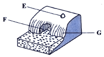
- The diagram below shows some coastal features. Name the features marked E, F and G.(3 marks)
SECTION B
Answer question 6 and any other two questions from this section.
- Study the map of Kijabe 1:50,000 (sheet 134/3) provided and answer the following questions.
-
- Convert the scale of the map extract into a statement scale. ( 2 marks)
- What is the bearing of the pump house at grid square 3893 from the trigonometrical station at Mweri?( 2 marks)
- Calculate the area of the part of the forest to the east of easting 40 and south of northing 97. Give your answer in square kilometres. (2 marks)
-
- Apart from forest, give three types of natural vegetation found in the area covered by the map.(3 marks)
- Identify the three river drainage patterns found in the area covered by the map. (3 marks)
-
- Using a vertical scale of 1 cm to represent 100 metres, draw a cross section from the water tank on grid square 2592 to the peak of Kijabe hill on grid square 2699.(4 marks)
On it, mark and label the following:- All weather road-bound surface (1 mark)
- Railway line (1 mark)
- Steep slope. (1 mark)
- Calculate the vertical exaggeration of the cross section. (2 marks)
- Using a vertical scale of 1 cm to represent 100 metres, draw a cross section from the water tank on grid square 2592 to the peak of Kijabe hill on grid square 2699.(4 marks)
- Citing evidence from the map, identify two economic activities in the area covered by the map.(4 marks)
-
-
-
- Define the term vulcanicity (2 marks)
- Name the three stages in the life cycle of a volcano. (3 marks)
- Describe how each of the following volcanic features are formed:
- Lava plateau (4 marks)
- Geyser (4 marks)
- Caldera. (4 marks)
- Explain four positive ways in which volcanic features influence human activities. (8 marks)
-
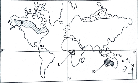
- The map below shows some vegetation regions of the world. Use it to answer question a(i) and a(ii).
-
- Name the vegetation marked H, J and K. (3 marks)
- Describe the characteristics of the vegetation found in the area shaded and marked L.(6 marks)
- Explain how each of the following factors influence distribution of vegetation:
- Rainfall (2 marks)
- Soils. (2 marks)
- State five uses of Savanna vegetation. (5 marks)
- You intend to carry out a field study on vegetation within the local environment.
- State three objectives you would formulate for the study. (3 marks)
- Give four reasons why it is important to have a work schedule. (4 marks)
-
-
-
- Apart from biological weathering, list two other types of weathering.(2 marks)
- Explain ways in which plants cause weathering of rocks. (6 marks)
- Explain how each of the following physical factors influence mass wasting:
- Earth movement (2 marks)
- Nature of rock materials. (2 marks)
- Describe each of the following processes of mass wasting:
- Avalanche (2 marks)
- Rock fall. 3 marks)
- Describe each of the following types of mass wasting:
- Earth flow (4 marks)
- Slump. (4 marks)
-
-
-
- Give three features found in the upper stage of a river. (3 marks)
- State four factors that favour the formation of braided channels. (4 marks)
- Explain the processes by which a river transports its load. (8 marks)
- With the aid of well labelled diagrams, describe how a river capture occurs. (7 marks)
- State three negative effects of rivers to human environment. (3 marks)
-
MAP: KIJABE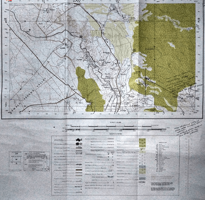
MARKING SCHEME
SECTION A
-
- Define the term environment. (2 marks)
- Environment is the external conditions that surround an organism/ external conditions that influence the development and behaviour of an organism
- Environment is the external conditions that surround an organism/ external conditions that influence the development and behaviour of an organism
- Name two divisions of physical Geography. (2 marks)
- Climatology/meteorology
- Biogeography/ecology
- Geomorphology
- Hydrology
- Pedology
- Define the term environment. (2 marks)
-
- Give three characteristics of comets. (3 marks)
- They are made up of frozen gases/dust/small rocky particles
- They have a a head and tail
- They move along oval-shaped orbit
- They cross orbits followed by the planets
- State three proofs that show the shape of the earth is spherical (3 marks)
- Circumnavigation along a straight path leads one to the starting point from the opposite direction
- Photographs taken from satellite clearly show the eearth is spherical
- The gradual emergence of a ship approaching the shore
- During lunar eclipse spherical shaped shadow of the earth is cast on the moon
- The earth is a planet and all planets are spheres
- The different times during which the sun rises and sets in different parts of the world
- The earth's horizon appears circular/ curved when viewed from a very high point.
- Give three characteristics of comets. (3 marks)
-
- Give two types of igneous rocks. (2 marks)
- Intrusive igneous rocks/ plutonic/ hypabasal
- Extrusive igneous rocks/ volcanic
- Identify three uses of rocks. (3 marks)
- Rocks weather down to form soils which support agriculture
- Some rock features are tourist attractions
- Rocks provide material for building/construction
- Some rocks provide raw materials for various manufacturing industries
- Some rocks are used in carving
- Some rocks are sources of salt
- Some rocks are sources of minerals
- Some are used as sharpening/ scrubbing tools
- Some rocks store water for use
- Some rocks form fossil fuels
- Give two types of igneous rocks. (2 marks)
- The table below shows the rainfall and temperature data for town Y. Use it to answer
Month J F M A M J J A S O N D Temperature(ºC) 21 21 20 18 15 14 13 13 15 16 18 20 Rainfall(mm) 24 25 30 74 17 143 131 126 70 55 31 27 -
- What is the mean annual range of temperature? (1 mark)
- 21-13 = 8ºC
- Calculate the rainfall totals for town Y. (1 mark)
- 753mm
- What is the mean annual range of temperature? (1 mark)
- State three climatic conditions experienced in the hot deserts. (3 marks)
- Low rainfall/ below 250mm a year
- High temperatures through out the year/ over 35ºC
- The diurnal range of temperatures is very large/ hot days and cool nights
- Low humidity/ below 45%
- Skies are cloudless/ clear
- There are strong dusty winds/ sand storms/ dry winds
-
-
- Differentiate between ocean and sea. (2 marks)
- An ocean is a large/ extensive body of saline water occupying a basin between continents, while a sea is a large body of saline water along the continental margins
- An ocean is a large/ extensive body of saline water occupying a basin between continents, while a sea is a large body of saline water along the continental margins
- The diagram below shows some coastal features. Name the features marked E, F and G.(3 marks)
- E- blowhole/ gloup
- Cave
- Cliff
- Differentiate between ocean and sea. (2 marks)
SECTION B
Answer question 6 and any other two questions from this section.
- Study the map of Kijabe 1:50,000 (sheet 134/3) provided and answer the following questions.
-
- Convert the scale of the map extract into a statement scale. ( 2 marks)
- 1cm rep 50 000
5 000cm = 50 000
100 000
= 0.5km - statement scale is 1cm rep 0.5km or ½km
- 1cm rep 50 000
- What is the bearing of the pump house at grid square 3893 from the trigonometrical station at Mweri?( 2 marks)
- 300º±1, N60ºW±1
- 300º±1, N60ºW±1
- Calculate the area of the part of the forest to the east of easting 40 and south of northing 97. Give your answer in square kilometres. (2 marks)
- full squares = 15
1/2 squares =20 →20/2=10
= 15 + 10= 25
=25 ± 1
- full squares = 15
- Convert the scale of the map extract into a statement scale. ( 2 marks)
-
- Apart from forest, give three types of natural vegetation found in the area covered by the map.(3 marks)
- Thicket
- Woodland
- Scrub
- Bamboo
- Scattered trees
- Identify the three river drainage patterns found in the area covered by the map. (3 marks)
- Radial drainage pattern
- Dendritic drainage pattern
- Parallel drainage pattern
- Apart from forest, give three types of natural vegetation found in the area covered by the map.(3 marks)
-
- Using a vertical scale of 1 cm to represent 100 metres, draw a cross section from the water tank on grid square 2592 to the peak of Kijabe hill on grid square 2699.(4 marks)
On it, mark and label the following:- All weather road-bound surface (1 mark)
- Railway line (1 mark)
- Steep slope. (1 mark)
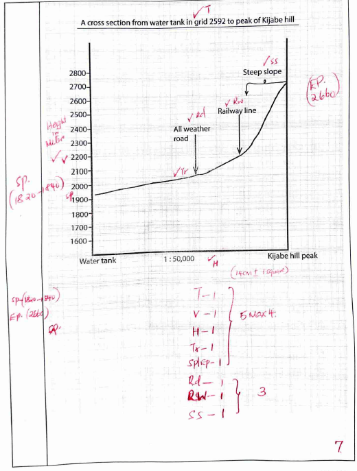
- Calculate the vertical exaggeration of the cross section. (2 marks)
VE= VS = 1:100m
HS 1:50 000cm
= 1: 10 000 = 1 x 5
1: 50 000
5 times
- Using a vertical scale of 1 cm to represent 100 metres, draw a cross section from the water tank on grid square 2592 to the peak of Kijabe hill on grid square 2699.(4 marks)
- Citing evidence from the map, identify two economic activities in the area covered by the map.(4 marks)
Economic activity Evidence -Transportation
-Forestry
-Trade
-Communication
-Quarrying
-Lumbering
-Cattle rearing/keeping
-Dairy farming
-Manufacturing/ procesing
-Crop farming-Roads/ railway/motorable track
-Forest/ forest station
-Shops
-Post office
-Murram pit quarry
-Saw mills
-Cattle dip
-Dairy
-Kagwe carbacid plant
-Plantation
Evidence should be tied to activity.
-
-
-
- Define the term vulcanicity (2 marks)
- Vulcanicity is the process through which liquid , solid or gaseous material are formed into the earth crust or on to the surface due to high pressure and temperature.
- Vulcanicity is the process through which liquid , solid or gaseous material are formed into the earth crust or on to the surface due to high pressure and temperature.
- Name the three stages in the life cycle of a volcano. (3 marks)
- Active
- Dormant
- Extinct
- Define the term vulcanicity (2 marks)
- Describe how each of the following volcanic features are formed:
- Lava plateau (4 marks)
- It is formed when magma reaches the earth surface through multiple vents/ fissures
- The lava is ultra-basic/ extremely fluid
- it flows over long distances, spreading evenly, covering hills and depressions
- The lava cools slowly and solidifies
- Successive eruptions build up more layers, building a thick plain land/ table land called lava plateau
- Geyser (4 marks)
- water percolates underground through cracks in the rock
- Water gets into contact with hot igneous rocks
- the water is superheated to form gases/ steam
- pressure builds up
- Pressure forces the steam and water to be ejected to the surface
- The water and steam is emitted intermittently as pressure level changes to form a geyser
- Caldera. (4 marks)
- lava pours out of a central vent to form volcanic cone
- Vent is sealed when lava solidifies
- Solidifies lava blocks gases and steam beneath, preventing them from escaping
- Pressure piles up below, leading to a violent eruption which blows off the top of the cone forming depression.( must be mentioned to secure maximum marks)
- The depression is large and circular and it is known as caldera
OR - Lava pours out of central vent to form volcanic cone
- Magma chambers are left empty/void
- Due to overlying weight at top of cone, pressure is exerted
- Top of the cone subsides forming a depression( this part must be mentioned to secure maximum marks)
- This depression is large and circular and is called a caldera
OR
(outward collapsing theory) - A volcano is build of ash and pyroclasts to form a dome
- Weak materials at the base are unable to support the overlying materials / weight
- Materials at thee base spread outward as top part subsides,(must mention to secure full marks) leading to large depression known as caldera.
- Lava plateau (4 marks)
- Explain four positive ways in which volcanic features influence human activities. (8 marks)
- Volcanic lava upon weathering forms fertile soils which are used in agricultural activity
- Some volcanic plugs/aureola, have valuable minerals which can be mined
- Steam jets are used in harnessing geothermal electricity for domestic /industrial use
- Some volcanic features attracts tourists earning a country foreign exchange
- Volcanic mountains influence the formation of relief rainfall on their slopes which encourage agricultural activities/settlement.
- Volcanic lakes used for fishing which is a source of income/ food
- Some lakes are a source of water for domestic/ industrial use
- Volcanic mountains are source of rivers which provide water for domestic/ industrial irrigation.
- Hotsprings/ spurs are used for medicinal purposes
- Some volcanic rocks are used as building materials
-
- The map below shows some vegetation regions of the world. Use it to answer question a(i) and a(ii).
-
- Name the vegetation marked H, J and K. (3 marks)
- H - Coniferous forest
- J -tundra
- K -Tropical desert
- Describe the characteristics of the vegetation found in the area shaded and marked L.(6 marks)
- Trees grow close to each other/ closely packed
- Trees form canopies/ 3 distinct layers
- Trees have straight smooth trunks
- Most tree species are hardwood
- The forest trees are evergreen
- Trees have broad leaves/ drip-tipped leaves
- Forests have little/ no undergrowth
- Forests consists of a variety of tree species
- Some trees have buttress roots
- The trees are tall
- The forest have climbers/ epiphytes
- Trees take long to mature
- Name the vegetation marked H, J and K. (3 marks)
- Explain how each of the following factors influence distribution of vegetation:
- Rainfall (2 marks)
- Areas receiving high rainfall encourage growth of many varieties of tree species/ luxuriant vegetation
- Areas receiving low rainfall have few species/ scanty vegetation
- Areas with low rainfall have stunted vegetation
- Soils. (2 marks)
- Deep well drained soils support growth of dense vegetation
- In fertile/ shallow/ thin soils support scanty vegetation
- Rainfall (2 marks)
- State five uses of Savanna vegetation. (5 marks)
- The grassland area is used for livestock farming/ grazing
- The vegetation provides habitat for wild animals
- Trees are used for bee keeping
- Some of the vegetation is used for medicinal purposes
- Some of the vegetation provides wild fruit
- Trees are a source of wood fuel
- Some vegetation provides building material
- Grass forage decompose to farm humus
- You intend to carry out a field study on vegetation within the local environment.
- State three objectives you would formulate for the study. (3 marks)
- To identify vegetation species dominant in the area.
- To find out how the local people benefit from the vegetation.
- To investigate problems facing vegetation in the area.
- To find out methods used to conserve vegetation in the area.
- Give four reasons why it is important to have a work schedule. (4 marks)
- It helps carry out the filed activities systematically.
- It helps in estimating the total time required for the study.
- It ensures all areas of study are adequately covered.
- It helps in assessing progress of the study.
- It enables for proper use of available time.
- It confines one to the scope of the study.
- State three objectives you would formulate for the study. (3 marks)
-
-
-
- Apart from biological weathering, list two other types of weathering.(2 marks)
- Mechanical/ physical
- Chemical
- Explain ways in which plants cause weathering of rocks. (6 marks)
- Roots of plants/ trees penetrate into the joints/ cracks of rocks widening them hence causing the rock to disintegrate.
- Plants decompose/ rot forming organic/ humic acids which cause rocks to decay/disintegrate.
- Mosses and lichens moisten rock surfaces facilitating chemical weathering.
- Widening of crack and joints by plant roots allows water and air to enter into the rocks hence accelerating weathering.
- Apart from biological weathering, list two other types of weathering.(2 marks)
- Explain how each of the following physical factors influence mass wasting:
- Earth movement (2 marks)
- Volcanic eruptions/ earthquakes cause tremors which may trigger displacement of materials wide spread mass wasting
- Volcanic eruptions/ earthquakes cause tremors which may trigger displacement of materials wide spread mass wasting
- Nature of rock materials. (2 marks)
- Loose/ unconsolidated materials easily move on slopes
- Large/ heavy materials move rapidly on a slope due to gravity
- Thin bedded layers tend to move faster on slopes
- Saturated rock materials move faster down a slope than dry materials
- Earth movement (2 marks)
- Describe each of the following processes of mass wasting:
- Avalanche (2 marks)
- It occurs when a fresh fall of snow is not firmly consolidated hence slides over older snow/ ice rapidly
- Thawing action of ice lubricates weathered rock and large ice blocks making them slide downhill rapidly
- Rock fall. 3 marks)
- Involves free fall of detached rock materials down a vertical/ steep slope
- They may fall directly downwards or bounce and roll down the slope
- It may occur due to freeze-thaw process/loosening action of plant roots/ heating and cooling/ earth movement
- Avalanche (2 marks)
- Describe each of the following types of mass wasting:
- Earth flow (4 marks)
- It occurs in humid conditions
- It occurs on moderate slopes
- Materials on the surface get saturated with water
- They flow/ slide downhill under the influence of gravity
- They leave behind shallow scars
- Form small bench-like terraces at their destination
- Slump. (4 marks)
- Occurs on very steep slopes/ concave
- Massive sedimentary strata overlying weak rock materials eg clay
- Underlying rock material is saturated with water, causing undercutting/ breaking off of the overlying rock materials
- Large mass of rock and loose materials shear/ tear away from concave plane
- Rock material slides downhill causing slump
- Earth flow (4 marks)
-
-
-
- Give three features found in the upper stage of a river. (3 marks)
- V-shaped valleys
- Potholes/ plunge pools
- Interlocking spurs
- Waterfall/rapids/cataracts
- Gorges/ canyons
- Winding channels
- State four factors that favour the formation of braided channels. (4 marks)
- River must be carrying a large load
- Should be reduction of stream gradient
- Should be presence of obstacles
- Should be reduction of volume of water in the river
- River flows at low velocity
- Widening of river channel
- Give three features found in the upper stage of a river. (3 marks)
- Explain the processes by which a river transports its load. (8 marks)
- Light insoluble materials such as silt and sand are carried in suspension and maintained within the turbulence of the water. Some of them float on surface of the water
- Large particles/ boulders are pushed and rolled along river bed by force of gravity and moving water
- Soluble material are dissolved in the water and carried down stream in form of solution
- Some particles/ pebbles which are fairly heavy are moved in a series of leaps, hops and jumps along river bed through process known as saltation.
(Process can score on its own but no the explanantion)
- With the aid of well labelled diagrams, describe how a river capture occurs. (7 marks)
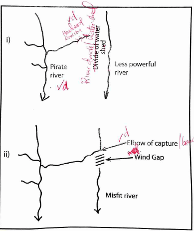
- River capture may only occur where there are 2 adjacent rivers/ share a watershed
- One river has more erosive power than the other
- The more powerful river erodes vertically faster than weaker one thus flows at lower level than than the other.
- The more power river erodes it's valley towards the other other river's valley through head-ward erosion.
- Eventually, the powerful river joins valley of weaker river
- The powerful river diverts the head waters of the weaker river into it's channel
- The diversion of the headwaters is called river capture.
- State three negative effects of rivers to human environment. (3 marks)
- Some rivers with almost stagnant water harbor waterborne diseases
- Rivers flooding during rainy season may cause destruction of property and loss of life
- Some rivers are habitats to dangerous animals which may attack humans/ destroy crops
- Some rivers are unnavigable hindering transportation
- River flooding also causes displacement of people
-
Join our whatsapp group for latest updates
Tap Here to Download for 50/-
Get on WhatsApp for 50/-
Download Geography Paper 1 Questions and Answers - KCSE 2020 past papers.
Tap Here to Download for 50/-
Get on WhatsApp for 50/-
Why download?
- ✔ To read offline at any time.
- ✔ To Print at your convenience
- ✔ Share Easily with Friends / Students


