
SUKELLEMO JOINT MOCK
Kenya Certificate of Secondary Education
GEOGRAPHY
PAPER 1
2 ¾ HOURS
Instructions to Candidates
- This paper has TWO sections: A and B.
- Answer ALL the questions in section A. In section B answer QUESTION 6 and any other TWO questions from the section.
SECTION A
Answer all the questions in this section
-
- Explain the relationship between geography and mathematics (2mks)
- When the local time is 2:00 p.m. at longitude 45°E , what is the longitude of a place whose local time is 8:00 P.M? (2mks)
-
- Give three examples of chemically formed sedimentary rocks (3mks)
- Describe how coral rocks are formed (3mks)
-
- List three external land forming processes which leads to formation of Lakes(3mks)
- State two ways in which lakes influence natural environment (2mks)
-
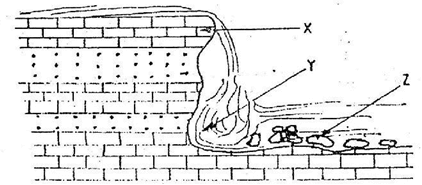
- The diagram below shows some of the surface features in a Karst scenery .Use it to answer questions (i) below
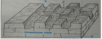
- Name the features marked X, Y and Z (3mks)
- Name two other features, which form on the surface of a karst scenery (2mks)
- The diagram below shows some of the surface features in a Karst scenery .Use it to answer questions (i) below
- Study the diagram below showing a soil profile. Use it to answer the questions that follow
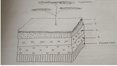
- Name the soil layers marked 2, 3 and 4 (3mks)
- Give two factors that influence soil leaching (2mks)
SECTION B
Answer question 6 and any other two questions from this section.
- Study the Map of Yimbo 1: 50,000 (Sheet 115/1) provided and answer the following questions.
-
- Convert the representative scale given on the map into a statement scale. (1mk)
- Give the latitude and longitude of the southwest corner of the area covered by the map.(2mks)
- Give the magnetic declination as at January 1970? (1mk)
-
- What is the height of Usengi hill? (1mk)
- What is the bearing of the Air Photo Principal point on grid reference 3274 from the trigonometrical station on grid reference 3980? (2mks)
- Describe the long profile of River Yala. (4mks)
-
- Using a scale of 1cm to represent 20m draw a cross section along northing 99 between easting 16 and 22. (3mks)
- On the cross section mark and name the following.
- A steep slope (1mk)
- A seasonal river (1mk)
- Thicket vegetation. (1mk)
- Calculate the gradient between grid reference 160990 and 220990. (2mks)
- Explain three physical factors that have influenced the distribution of settlements in the area covered by the map. (6mks)
-
-
- Other than the sun name two other heavenly bodies that makes up the solar system(2mks)
- Explain the origin of the earth according to the passing star Theory (6mks)
- Use the diagram below to answer question (c) i , ii and iii
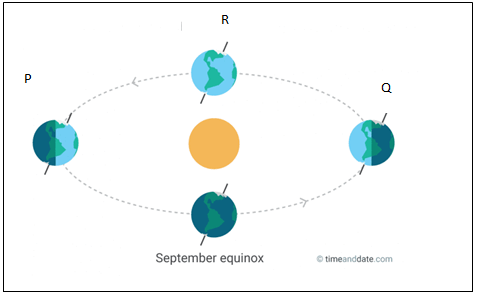
- Name the solstice marked P. (1mk)
- Identify the season represented in the region marked Q. (1mk)
- Which date of the year is the sun overhead at R (1mk)
- Give three reasons why the earth has a spherical shape (3mks)
- State three effects of the rotation of the earth on its axis (3mks)
- The diagram below represents the structure of the earth. Use it to answer question (a)
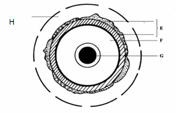
Name :- The layers marked E, F, G and H (4mks)
- State four characteristics of the outer core (4mks)
-
-
- What is folding? (2mks)
- Name three types of folds. (3mks)
- Name two orogenies known in geological history. (2mks)
-
- Apart from Fold Mountains, name two other features resulting from folding. (2mks)
- The following map shows the location of fold mountain ranges of the world.
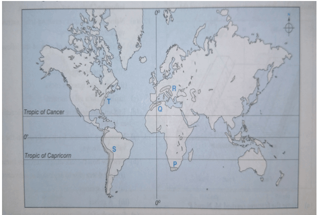
Name the mountain ranges marked P,Q, R, S and T. (5mks) - With well-labelled diagrams, use the Plate Tectonics theory to explain the formation of Fold Mountains. (5mks)
- Explain three ways in which folding influence human activities. (6mks)
-
-
-
- Using a well-labeled diagram, show the main processes of the hydrological cycle. (5mks)
- Differentiate between a watershed and a catchment area. (2mks)
-
- The diagram below shows a waterfall. Name the features marked X, Y and Z. (3mks)
- State three ways in which a waterfall may form. (3mks)
- The diagram below shows a waterfall. Name the features marked X, Y and Z. (3mks)
- The diagram below shows a type of a delta. Use it to answer the questions below.
- Name the type of the delta shown above (1mk)
- Identify the features marked H and J. (2mks)
- Describe the formation of the delta shown above. (3mks)
- You are planning to carry out a field study on the lower course of a river
- Give two reasons why you would require a route map (2mks)
- State two activities you would carry out to determine why deposition occurs at this stage (2mks)
- State two follow- up activities you would be involved in after the field study ( 2mks)
-
-
-
- What is an ice sheet? (2mks)
- Give two reasons why there are no ice sheets in Kenya. (2mks)
- Describe how a pyramidal peak is formed. (5mks)
- The diagram below shows types of moraines in a valley glacier.
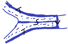
- Name the type of moraine marked S, T and V. (3mks)
- Explain three effects of glaciated landscape in upland areas on human environment. (6mks)
- Students from a school near Mt. Kenya were planning to carry out a field study on the glaciated features on the mountain.
- Give three reasons why it would be difficult to undertake the field study on glaciated features on the Mountain. (3mks)
- Describe how the students would use a photograph of Mt. Kenya to identify the glaciated features on the Mountain. (2mks)
- Give two types of glaciers they would identify during your study.
-
MARKING SCHEME
SECTION A
Answer all the questions in this section
-
- Explain the relationship between geography and mathematics (2mks)
- Geography uses mathematical formulae to calculate distances, areas, and population densities .it relies on mathematics for statistical analysis.
- Mathematics relies on geography in giving directions and calculating bearing.
- When the local time is 2:00 p.m. at longitude 45°E , what is the longitude of a place whose local time is 8:00 P.M? (2mks)
- Time at longitude X is 8:00 p.m.
I.e. 6 hours ahead of that at 45 °E
From 2 pm to 8 p.m =6 hours
This is 6 hours ahead of that at 45°E
6 hours *60 minutes
360 minutes =90
4 minutes
X is 90° East of longitude 45°E
=90°+45°=135°
Longitude X is 135°
- Time at longitude X is 8:00 p.m.
- Explain the relationship between geography and mathematics (2mks)
-
- Give three examples of chemically formed sedimentary rocks (3mks)
- Limonite
- Travertine/tufa
- Dolomite
- Gypsum
- Rock salt
- Flint
- Trona
- Haematite
- Describe how coral rocks are formed (3mks)
- Tiny marine organism called coral polyps live in colonies in the sea
- Polyps extracts calcium from sea water
- The polys die and their hard skeletons of calcium carbonate accumulate into a solid mass
- Successive colonies grow on the solid mass, thus the rock grows in size
- The spaces between the dead coral polyps are cemented by calcareous algae
- Give three examples of chemically formed sedimentary rocks (3mks)
-
- List three external land forming processes which leads to formation of Lakes (3mks)
- Weathering /by solution in limestone areas
- Deposition by water/ice
- Meteorite falling
- Mass movement /mass wasting
- State two ways in which lakes influence natural environment (2mks)
- Lakes are reservoirs in the water cycle
- Support bio-diversity/flora and fauna
- Enables self-purification of water and air
- Modify local weather and climate
- Regulation of river flow
- List three external land forming processes which leads to formation of Lakes (3mks)
-
- The diagram below shows some of the surface features in a Karst scenery .Use it to answer questions (i) below
- Name the features marked X, Y and Z (3mks)
- X is a clint
- Y is a joint
- Z is a grike
- Name two other features, which form on the surface of a karst scenery (2mks)
- Swallow holes
- Dolines
- Polje
- Dry valleys uvala
- Gorges
- Name the features marked X, Y and Z (3mks)
- The diagram below shows some of the surface features in a Karst scenery .Use it to answer questions (i) below
- Study the diagram below showing a soil profile. Use it to answer the questions that follow
- Name the soil layers marked 2, 3 and 4 (3mks)
- 1 -Humus layer
- 2 -Top soil
- 3 -Sub soil
- 4 -Weathered parent material
- Give two factors that influence soil leaching (2mks)
- Nature of soil/solubility of minerals
- Amount of rainfall
- Nature of the slope/gradient
- Name the soil layers marked 2, 3 and 4 (3mks)
SECTION B
Answer question 6 and any other two questions from this section.
- Study the Map of Yimbo 1: 50,000 (Sheet 115/1) provided and answer the following questions.
-
- Convert the representative scale given on the map into a statement scale. (1mk)
1:50,000
50,000/100=500m
500/1000=0.5km
One centimeter represents zero point five kilometers. - Give the latitude and longitude of the south west corner of the area covered by the map. (2mks)
- 00 15’S and 34015’E
- 00 15’S and 34015’E
- Give the magnetic declination as at January 1970? (1mk)
- 2028’
- Convert the representative scale given on the map into a statement scale. (1mk)
-
- What is the height of Usengi hill? (1mk)
1269m
- What is the bearing of the Air Photo Principal point on grid reference 3274 from the trigonometrical station on grid reference 3980? (2mks)
- Bearing=2290 +/-1
- Bearing=2290 +/-1
- Describe the long profile of River Yala. (4mks)
- The general flow of the River is from North East to the Northern part of the area covered by the map.
- The river and its tributaries form a dendritic drainage pattern.
- A great section of the river flows through a papyrus swamp
- The river has many meanders.
- To the east of easting 36, the river is in its youthful stage and to the west of the same easting 36; the river is in its mature stage.
- River Yala is a permanent river.
- What is the height of Usengi hill? (1mk)
- Using a scale of 1cm to represent 20m draw a cross section along northing 99 between easting 16 and 22. (3mks)
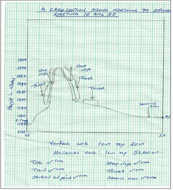
- On the cross section mark and name the following.
- A steep slope (1mk
- A seasonal river (1mk)
- Thicket vegetation. (1mk)
- Calculate the gradient between grid reference 160990 and 220990. (2mks)
- Gradient=Vertical rise/Horizontal equivalent
(1160m-1140m)/12cm=20m/(12cmx50,000cm)
20m/600,000cm=20m/6000m
=1/3000.
- Gradient=Vertical rise/Horizontal equivalent
- Using a scale of 1cm to represent 20m draw a cross section along northing 99 between easting 16 and 22. (3mks)
- Explain three physical factors that have influenced the distribution of settlements in the area covered by the map. (6mks)
- Relief- There are no settlements on hilly places like on Usengi Hills due to the rugged terrain which makes it difficult to put up settlements
- There is dense settlement on the gentle slopes because it is easy to put up settlements and to carry out agriculture
- There are no settlements on the river valleys due to fear to of flooding.
- Vegetation-There are no settlements in the areas with thicket vegetation due to the fear of attacks from pests
- There are no settlements in the areas covered by papyrus swamp vegetation. The areas are waterlogged.
- Drainage-There is linear settlement along some rivers for instance along River Alara Yenga.
-
-
- Other than the sun name two other heavenly bodies that makes up the solar system (2mks)
- Eight planets
- Satellites (moons)
- Dwarf planets
- Asteroids
- Comets
- Explain the origin of the earth according to the passing star Theory (8mrks)
- A star with a greater gravitational pull passed near the sun;
- It attracted large quantities of gaseous materials from the sun;
- The materials split, cooled and condensed to form planets;
- The planets were set in orbit by the passing star;
- Use the diagram below to answer question (c) I ii and iii
- Name the solstice marked P. (1mrk)
- Summer solistice
- Summer solistice
- Identify the season represented in the region marked Q. (1mrk)
- Winter
- Winter
- Which date of the year is the sun overhead at R (1mrk)
- 21st march
- 21st march
- Name the solstice marked P. (1mrk)
- Give two reasons why the earth has a spherical shape (3mrks)
- Gravitational force – This force affects all parts of the earth pulling everything towards the centre. This has had effect on making the earth’s shape round;
- Centrifugal force- Makes the equator bulge;
- Centripetal force- causes the flattening at the poles
- All this forces forces make the earth spherical;
- State three effects of the rotation of the earth on its axis (3 mrks)
- Causes day and night
- Causes high and low tides
- Causes deflection of winds and ocean currents
- The diagram below represents the structure of the earth. Use it to answer question (a)
Name :- The layers marked E, F ,G and H (3mrks)
- Crust
- Mantle
- Inner core
- State three characteristics of the outer core (3mrks)
- It is composed of hot molten rock material of iron and nickel.
- It has a density of about 10.5 gm/cc.
- Its temperatures goes up to 37000C
- It is estimated to be 2,200 kilometers thick.
- The layers marked E, F ,G and H (3mrks)
- Other than the sun name two other heavenly bodies that makes up the solar system (2mks)
-
-
- What is folding? (2mks)
- Folding is a process of crustal distortion which causes the rocks to bend upwards or downwards.
- Folding is a process of crustal distortion which causes the rocks to bend upwards or downwards.
- Name three types of folds. (3mks)
- Simple symmetrical folds
- Asymmetrical folds
- Overfolds
- Isoclinal folds
- Recumbent folds
- The nappe/overthrust fold
- Anticlinorium and syclinorium complex
- Name two orogenies known in geological history. (2mks)
- Charnian orogeny
- Calendonian orogeny
- Hercynian orogeny
- Alpine orogeny
- What is folding? (2mks)
-
- Apart from Fold Mountains name two other features resulting from folding. (3mks
- Inter montane plateau
- Inter montane basins
- Ridge and Valley landscape
- Rolling plains
- Name the mountain ranges marked P, Q, R, S and T. (5mks)
- P is Cape Ranges
- Q is Atlas Mountains.
- R is the Alps.
- S is the Andes.
- T is the Appalachian Mountains.
- With the aid of well- labeled diagrams, use plate tectonics theory to explain the formation of Fold Mountains. (5mks)
- Fold mountains can form when an oceanic plate and a continental plate move towards each other.
- The oceanic plate sinks beneath the continental one at the compressional boundary.
- The sediments on the ocean bed in the area together with the rocks forming the edge of the continent are compressed, causing them to fold into mountains.
(3mks for explanation, 2mks for diagrams)
- Apart from Fold Mountains name two other features resulting from folding. (3mks
- Explain three ways in which folding influence human activities. (6mks)
- Heavy rainfall on the windward side of Fold Mountains support agriculture.
- The heavy rainfall and snow make fold mountains to be source of rivers providing water for irrigation, domestic and industrial use.
- Mountainous landscape provides unique scenery making it attractive to tourists.
- The process of folding can bring valuable minerals near the surface making it easier for mining to bury them making them inaccessible.
- The cold descending winds in the mountainous landscape sometimes destroy crops.
-
-
-
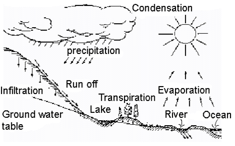
- Using a well-labeled diagram, show the main processes of the hydrological cycle (5mks)
- Differentiate between a watershed and a catchment area. (2mks)
- A watershed is a ridge line or boundary line separating drainage or river system or basins while a catchment area is an area or land from which a river or a reservoir draws its water or source of a river.
- Using a well-labeled diagram, show the main processes of the hydrological cycle (5mks)
-
- The diagram below shows a waterfall. Name the features marked X, Y and Z. (3mks)
- X- Resistant rock/sill/cap rock.
- Y-Plunge pool
- Z- Rock boulder.
- State three ways in which a waterfall may form. (3mks)
- When a river’s channel passes over horizontally underlying hard resistant rocks.
- When a river enters into a valley through an escarpment.
- When a river plunges into the lower coastal land from a plateau.
- Along coasts where mountains reach the coastline through a cliff.
- Waterfalls may occur in the glaciated highlands where rivers flow from hanging valleys and plunge into the floor of U-shaped valleys.
- When a landslide blocks a river forming a barrier lake, a waterfall may occur at the point of overspill.
- The diagram below shows a waterfall. Name the features marked X, Y and Z. (3mks)
- The diagram below shows a type of a delta. Use it to answer the questions below.
- Name the type of the delta shown above (1mk)
- Bird’s foot delta
- Bird’s foot delta
- Identify the features marked H and J. (2mk)
- H- Distributaries
- J- A lagoon/ lake
- Describe the formation of the above delta. (3mks)
- This type of delta generally forms on rivers carrying large quantities of fine alluvium into waters where there is low wave energy.
- The delta has very few distributaries and the ones present form a pattern resembling the foot of a bird.
- Name the type of the delta shown above (1mk)
- You are planning to carry out a field study on the lower course of a river
- Give two reasons why you would require a route map (2mk)
- To help identify the direction to follow
- To help prepare a work schedule
- To help identify the location of features for study
- To help estimate distances to be covered.
- Help estimate the time the field study is likely to take.
- State two activities you would carry out to determine why deposition occurs at this stage (2mks)
- Measuring of the gradient
- Finding out the nature of the load
- Finding out the amount of the load
- Establishing the velocity of the river
- Observing obstacles in the stream channel or distributaries
- Measuring of the width or depth of the river
- State three follow- up activities you would be involved in after the field study (2mks)
- Discussion on the findings with the rest of the class
- Write reports of data collected
- Display photographs or items collected
- Draw diagrams/ charts/ bars/ tables to present the information obtained
- Model the flood plain
- Give two reasons why you would require a route map (2mk)
-
-
-
- What is an ice sheet? (2marks)
- An ice sheet is a large continuous mass of ice which covers extensive areas of lowland.
- An ice sheet is a large continuous mass of ice which covers extensive areas of lowland.
- Give two reasons why there are no ice sheets in Kenya. (2marks)
- Kenya is located within the tropics where temperatures are high discouraging formation of ice sheet.
- Kenya is located in the low latitude areas where formation of ice sheets is limited.
- What is an ice sheet? (2marks)
- Describe how a pyramidal peak is formed. (5marks)
- Ice accumulates in the pre-existing depressions/hollows on the mountain top.
- Ice exerts pressure on the hollows.
- Plucking action of ice enlarges the hollows allowing more ice to accumulate.
- Freeze and thaw action leads to expansion of the hollows making them large basins called cirques.
- Nivation acts on the back wall of adjacent basins making them recede into the mountain side.
- Steep knife edged ridges called arêtes are formed which separate the basins.
- Three or more of these ridges converge at the mountain top forming a sharp and steep pointed peak called a pyramidal peak.
- The diagram below shows types of moraines in a valley glacier.
- Name the type of moraine marked S, T and V. (3marks)
- S- Medial Moraine
- T-Lateral Moraine
- V-Terminal Moraine
- Explain three effects of glaciated landscape in upland areas on human environment. (6marks)
- Glaciated highlands/mountains form unique sites for tourist attraction in a country. Foreign exchange earned from these tourists is used to develop other sectors of the economy.
- Formation of hanging valleys in glaciated highlands due to glacial erosion forces water from tributaries to plunge into the main river occupying a U-shaped valley. This lead to the formation of waterfalls hence creating suitable locations for construction of hydroelectric power stations.
- Glaciated highlands encourage growth of nutritious pasture in summer which attracts grazing of dairy animals.
- Name the type of moraine marked S, T and V. (3marks)
- Students from a school near Mt. Kenya were planning to carry out a field study on the glaciated features on the mountain.
- Give three reasons why it would be difficult to undertake the field study on glaciated features on the Mountain. (3marks)
- Climbing the mountain to access the features may be difficult due to the rugged terrain.
- The thick vegetation on the slopes of the mountain may hinder the movement.
- Sudden weather condition like rainfall/extreme low temperature may hinder their work.
- Attack by wild animals may make it difficult to access the area.
- Describe how the students would use a photograph of Mt. Kenya to identify the glaciated features on the Mountain. (2marks)
- By dividing the picture into parts.
- By observing and identifying the features in each part of the photograph.
- By labeling the observed.
- Give two types of glaciers they would identify during your study. (2marks)
- Cirque glaciers
- Ice caps
- Valley glaciers
- Give three reasons why it would be difficult to undertake the field study on glaciated features on the Mountain. (3marks)
-
Join our whatsapp group for latest updates
Tap Here to Download for 50/-
Get on WhatsApp for 50/-
Download Geography Paper 1 Questions and Answers - Sukellemo Joint Mock 2020/2021.
Tap Here to Download for 50/-
Get on WhatsApp for 50/-
Why download?
- ✔ To read offline at any time.
- ✔ To Print at your convenience
- ✔ Share Easily with Friends / Students


