
Instructions to candidates.
- Write your name and index number in the spaces provided above.
- Sign and write the date of the examination in the spaces provided above.
- This paper has two sections: A and B.
- Answer all the questions in sections A.
- Answer question 6 and any other two questions from Section B.
- All answers must be written in the answer booklet provided.
- This paper consists of 6 printed pages.
- Candidates should check the question paper to ascertain that all the pages are printed as indicated and that no questions are missing.
- Candidates should answer the questions in English.
For Examiner's Use Only
| Section | Questions | Maximum Score | Candidate's Score |
| A | 1-5 | 25 | |
| B | 6 | 25 | |
| 25 | |||
| 25 | |||
| Total Score |

QUESTIONS
SECTION A
Answer all questions in this section.
- The diagram below represents the structure of the earth. Use it to answer question follow (a)
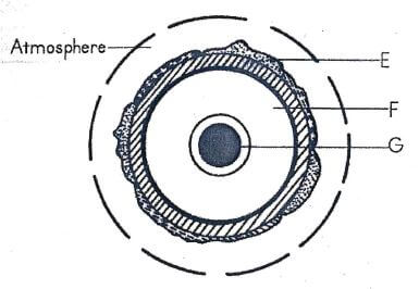
- Name the;
- layers marked E and F (2 marks)
- mineral that make up the layer marked G (1 mark)
- Give two effects of the rotation of the earth on its axis. (2 marks)
- Name the;
-
- What is a glacier? (2 marks)
- Name three types of glacier. (3 marks)
-
- Name two boundaries according to the plate tectonic theory. (2 marks)
- Give three effects of the movement of tectonic plates. (3 marks)
-
- What is an earthquake? (2 marks)
- Identify the scales used to measure:
- the intensity of earthquake. (1 mark)
- the magnitude of earthquake (1 mark)
-
- Give three characteristics of a river in its middle stage. (3 marks)
- The diagram below shows a Bird's Foot delta.
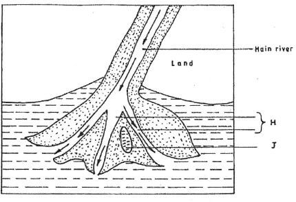
Identify the features marked H and J. (2 marks)
SECTION B
Answer question 6 and any other two questions in this section
- Study the map of Busia 1:50,000 (sheet 101/1) provided and answer the following questions.
-
- What type of map is Busia map extract? (1 mark)
- Identify the two types of scales on the map extract. (2 marks)
-
- Measure the length of the road C 529 from Matayo to Lwanda. (2 marks)
- Calculate the area of to the East of road B 8/3 and south of road C 526 on the South Eastern part of the area (2 marks)
- Describe the drainage of the area covered by the map. (5 marks)
- Citing evidence from the map, give three economic activities carried out on the area covered by the map (6 marks)
- Using of a scale of 1 cm to represent 100 metres, draw a cross-section along Easting 26 from Northing 31 to Northing 39 (2 marks)
On the cross-section, mark and name the following features:- A hill (1 mark)
- Road C 529(1 mark)
- A stream(1 mark)
- Nawolo swamp(1 mark)
- Foot path(1 mark)
-
-
- Describe the characteristics of rock under the following headings;
- colour(2 marks)
- cleavage(2 marks)
- hardness(2 marks)
-
- Give two types of igneous rock.(2 marks)
- Describe how coral rocks are formed.(4 marks)
- Explain four significance of rocks to the economy of Kenya. (8 marks)
- You are planning to carry out a field study on the rocks within your school environment.
- Give two secondary sources of information you would use to prepare for the field study. (2 marks)
- Suppose during the field study you collected marble, sandstone and granite. Classify each sample according to its mode of origin. (3 marks)
- Describe the characteristics of rock under the following headings;
-
-
- Give four reasons why some lakes in Kenya have saline water. (4 marks)
- Apart from Lake Magadi, name two lakes within the Rift Valley in Kenya that have high levels of salinity. (2 marks)
- Describe how the following lakes are formed:
- Crater lake; (5 marks)
- Oasis;(4 marks)
- Lagoon.(4 marks)
- Give two ways in which lake breezes influence the climate of the adjacent land.(2 marks)
- Explain how each of the following has affected lakes in Kenya:
- deforestation,(2 marks)
- industrialisation (2 marks)
-
-
- State the effects of fohn winds to the climate of the areas it blows to. (3 marks)
-
- What is meant by the term Inter Tropical Convergence Zone (ITCZ)? (2 marks)
- Identify the type of rainfall associated with the ITCZ.(1 mark)
- Explain how the rainfall associated with ITCZ is formed. Illustrate your answer. (8 marks)
- Describe the characteristics of the vegetation found in Equatorial forests. (6 marks)
- Suppose you are to carry a field study on vegetation around the school. State five characteristics of vegetation you would study. (5 marks)
-
-
- What are tides? (2 marks)
- Give three causes of ocean currents. (3 marks)
- Name the three ocean currents along the western coast of Africa. (3 marks)
-
- State three characteristics of submerged lowland coasts. (3 marks)
- Explain three factors that determine the rate of coastal erosion. (6 marks)
- With the aid of labelled diagrams, describe the process through which a stack is formed. (8 marks)
-
Join our whatsapp group for latest updates
Tap Here to Download for 50/-
Get on WhatsApp for 50/-
Download Geography Paper 1 Questions - Alliance Girl's High School Mock December 2020.
Tap Here to Download for 50/-
Get on WhatsApp for 50/-
Why download?
- ✔ To read offline at any time.
- ✔ To Print at your convenience
- ✔ Share Easily with Friends / Students


