
Instructions to candidates
- This paper consists of two sections; A and B
- Answer all the questions in section A in the spaces provided after each question.
- In section B, answer question 6 and any other two questions.
- Candidates should answer the questions in English.
SECTION A
Answer all the questions in this section
-
- If the time in Town Y which is 750 W is 5 a.m., what is the time in town P which is 400 E? (3 marks)
- How does rotation of the earth cause the occurrence of day and night? (2 marks)
-
- Name two elements of weather that can be recorded at a school weather station. (2 marks)
- The diagram below represents a weather measuring instrument. Use it to answer the following questions.
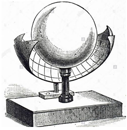
- Identify the weather element measured using the above equipment. (1 mark)
- Describe how the above instrument is used. (2 marks)
- Describe how igneous rocks are formed (5 marks)
-
- Name the types of delta found at the mouth of;
- River Nile (1 mark)
- River Omo (1 mark)
- State three conditions necessary for the formation of a delta (3 marks
- Name the types of delta found at the mouth of;
- The diagram below shows mountain vegetation zones, use it to answer the questions that follow.
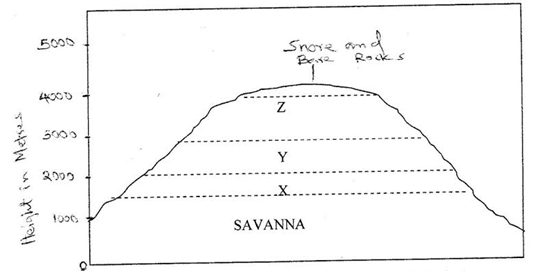
- Name the vegetation zones marked X, Y and Z. (3 marks)
- State two reasons why the mountain top has no vegetation. (2 marks)
SECTION B
Answer question 6 and any other two questions from this section.
- Study the map of Kijabe 1:50, 000(sheet 134/3) provided and answer the following questions
-
- Identify two types of scales used in the map of Kijabe (2 marks)
- Name any two drainage features found in Kijabe (2 marks)
-
- Measure the distance of the road B3 from Narok to the junction at road 4104. Give your answers in kilometers and meters. (2 marks)
- Give the economic activities represented by the following features in Kijabe (4 marks)
- Saw mills.
- Water troughs
- Forest guard post
- Kagwe Carbacid plant
- Name three human features found in grid square 3690. (2 marks)
- Describe the distribution of natural vegetation in the area covered by the map. (6 marks)
- Citing evidence from the map, explain three factors that have favored trade in Kijabe area (6 marks)
-
-
-
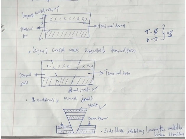
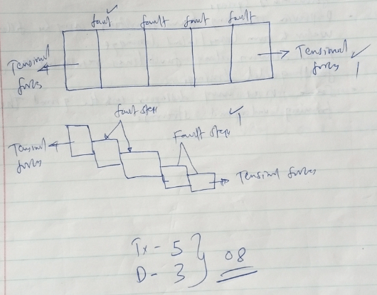
- Name one tectonic forces that causes faulting. (1 mark)
- Differentiate between a normal fault and a reverse fault. (2 marks )
- Using labelled diagrams, describe how the following features are formed
- Block mountain (8 marks)
- Fault steps (8 marks)
- Explain three ways in which faulting may influence drainage (6 marks)
-
-
-
- Give three underground features found in a karst landscape (2 marks)
- State three reasons why there are few settlements in a karst landscape. (3 marks)
- Describe how the following surface features in limestone are formed:
- Grikes and Clints (4 marks)
- Uvala (5 marks)
- Explain three negative effects of resultant features in limestone areas on human activities.(6 marks)
- Students of Nyamira Girls High School are planning to go for a field study in areas of Karst scenery.
- State two reasons why it was important to seek permission from school administration (2 marks)
- Give two reasons why they would need a map of the area of study (2 marks)
-
-
-
- Define desertification (2 marks)
- State two factors influencing wind transport (2 marks)
- Describe how the following features are formed:
- Oasis (5 marks)
- Bajada (5 marks)
- Explain three significance of desert land forms to human activities (6 marks)
- You intend to carry out a field study in a desert landform
- Give two methods you would use to collect information (2 marks)
- State the follow up activities you would carry out after the field study (2 marks)
-
-
- What is glacier (2 marks)
- State the distinctive characteristics of the following features resulting from glacial erosion;
- Corrie (2 marks)
- A pyramidal peak (2 marks)
- Describe how the following features are formed;
- Terminal moraine (4 marks)
- Crag and Tail (4 marks)
- Cirque lake (5marks)
- Explain three positive effects of glaciation in lowlands (6marks)
MARKING SCHEME
SECTION A
-
- difference in degrees between Y & P
40° + 75° = 115°
1° = 4 mins
115° = (115 ×4)
= 460 mins
60
= 7 hr 40 mins
Time at P= (5hr + 7hr 40 mins)
=12: 40 p.m
Any 3@1 (3 marks) - During rotation of the earth, the half side that faces the sun receives sunlight hence day, while the half side of the earth that faces away from the sun is darkness, hence night Any 2@1 ( 2marks)
- difference in degrees between Y & P
-
-
- sunshine
- Temperature
- Humidity
- Wind
- Rainfall
- Atmospheric pressure Any 2@1 ( 2marks )
-
- Duration and intensity of sunshine Any 1@1 (1 mark)
-
- When the sun shines, the glass ball focuses the rays on the sensitized paper
- The focused rays burn the sensitive paper
- Continuous sunshine produces a continuous burnt line on the sensitized paper
- Intermittent sunshine shows gaps of unburnt parts on the sensitized paper
- The length of all the burnt sections is added to obtain total hours of sunshine for the day
- The readings are taken and recorded daily after which sensitized paper is changed for the next day Any 6 max 2@1 (2 marks)
-
-
- Earth movements leads to formation of cracks across the crust
- Magma extrude through onto the earth surface
- It cools and solidify forming materials. These form extensive igneous rocks
- Some remains in the interior, cools forming intrusive igneous rocks
Any 5@1 (5 marks)
-
-
- River Nile- arcuate delta
- River Omo- birds foot delta
-
-
absence of obstacles in the river course
-
shallow shore
-
Large amount of load/ silt
-
Absence of strong
-
-
-
-
- X- tropical rainforest/ equatorial forest/ rainforest/ temperate rainforest
- Y- bamboo
- Z- Heath and moor land Any 3 @1 ( 3marks)
-
- thin soils that supports little vegetation
- very low temperatures that inhibits pant growth
- permanent snow cover prevents vegetation growth
- strong winds that uproot vegetation
Any 2 @1 (2 marks)
-
SECTION B
-
-
-
- Ratio/RF scale
- Linear scale any 2@1 (2 marks)
-
- hot springs
- Rivers
- Boreholes Any 2@1 (2 marks)
-
-
- 6700 M/ 6 KM +or – 1
( 6600m – 6800m/ 6 Km 600 m – 6Km 800m) Any 2@1 (2 marks) -
- sawmills – Lumbering
- water trough – cattle rearing
- Forestguard post – Administration/ Forestry Any 4@1 (4 marks)
- Kagwe carbacid plant – processing/ manufacturing
- 6700 M/ 6 KM +or – 1
-
- houses
- Road
- Bridge Any 3@1 (3 marks)
-
- presence of Nyamweru forest
- presence of scrub vegetation in
- presence of presence of bamboo in arid 3901
- presence of scattered trees in arid 3401
- presence of woodland in arid 3197 Any 6@1 (6 marks)
-
- presence of means of transport evidenced by high density of road network that ease delivery
- presence of market evidenced by many settlements around Kijabe suggesting that purchase the products
- the area is productive evidenced by many economic activities e.g coffee farming which provides items for trade. Any 3@2 (6 marks)
-
-
-
-
- Tensional forces
- Compressional forces Any 1@1 (1 mark)
-
- Normal fault is caused by tensional forces while reverse faults occur due to compressional forces
- In normal fault, the upthrow moves away from the down throw, while in the reverse fault the upthrow rides over the down throw.
-
-
- Block mountain
- Layers of the earth crust is subjected to tensional forces
- Normal faults are formed
- The side blocks are pulled apart and subside
- The central block remains projected on the earth surface forming a block mountain
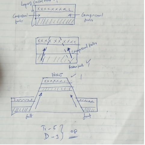
OR - Layer of crustal rocks are subjected to compressional forces
- Reverse faults develops
- The middle block is pushed upwards along the faults relative to the side blocks
- The raised block (middle block) stand above the earth surface forming the block mountain
- Fault steps
- Layers of earth crust are subjected to tensional/ compressional forces
- A series of faults develops across the earth’s crust/normal/reverse faults
- Blocks of land occur between the fault lines
- The blocks of land subside/ rise at levels forming steps/ terraces
- The steps/terraces forms fault steps
- Block mountain
-
- uplift of landscapes due to faulting may cause rivers to reverse their direction of flow
- Vertical faulting across a river followed by downward displacement may lead to formation of a waterfall
- Uplift of a river channel due to faulting may cause river rejuvenation
- Faulting may expose underground water table leading to formation of springs
- Depression resulting from faulting may be filled with water to form lakes/inland drainage
- Rivers flowing along fault lines results into the formation of faults guided by drainage
- Some rivers may disappear into the ground through faulting forming underground streams
Any 3@2 (6 marks)
-
-
-
-
- limestone pillars
- stalagmite
- stalactites
- underground streams/rivers
- caves
Any 2 @ 1 (1 mark)
-
- the area has rock outcrop which are rugged
- the area has poor or scarcity of vegetation
- the area has thin soils
- the area has inadequate water supply
Any 3 @ 1 (3marks)
-
-
- Doline
- Rain water absorbs carbon (iv) oxide to form weak carbonic acid
- As the rain water percolates through the rock it erodes through solution
- As the rock gradually dissolve the joints merge to form a small basin
- Further solution enlarges the basin to form a large depression called a Doline
Any 4@1 ( 4 marks)
- Uvala
- Rain water absorbs carbon (iv) oxide in the atmosphere forming weak carbonic acid.
- As the rain water percolates through the rocks it erodes through solution
- Further solution leads to merging of several joints to form a Doline
- Several dolines existing adjacent to each other may join due to further solution forming a very large depression.
- This is an Uvala.
Any 5 @ 1 (5 marks)
- Doline
-
- Rugged landscape discourages settlements
- The region has intermittent streams that disappear underground causing scarcity of water for domestic/ agricultural use
- The area has scarce vegetation that discourages settlement
- Thin soils within the area discourages agriculture
- Rocky surface which is not conducive for settlement
Any 3 @2 (6 marks)
-
-
- It is an official requirement
- To enable the administration to arrange for transportation
- To enable the administration, arrange for lunch/meals
- To enable the administration, take care of the disruption of the school program that will occur
- To enable the administration, prepare essential tools for use
- To enable administration, provide entry fee if required
Any 2 @ 1 (2 marks)
-
- to show the extent of area of study
- To show the route to be followed during the study
- To show general nature of the territor
- To be able to estimate distances
Any 2 @ 1 (2 marks)
-
-
-
-
-
- Desertification refers to the encroachment of arid conditions into formerly productive land/areas
- Process by which formerly productive land is degraded through climate variations and human activities
Any 2 @1 (2 marks )
-
- absence of vegetation cover
- presence of loose unconsolidated materials
- low moisture content in soil
- Strong winds
Any 2 @1 (2 marks)
-
-
- Oasis
- Wind attacks a crack on a desert surface
- Wind deflection creates a depression
- Further erosion and weathering enlarges the depression
- The depression reaches the water table
- The water oozes out and collects in the depression to form an oasis
Any 5 @1 ( 5 marks)
- Bajada
- Torrential rainfall occurs in an upland surrounding a basin forming seasonal streams which carry sand and silt
- When the river reaches the basin, it deposits materials outward in all directions
- Further deposition leads to accumulation of materials forming an alluvial fan
- The alluvial fan is enlarged and merges with others forming a piedmont alluvial fan
- The load is moved further and eventually a layer of deposits forms on the piedmont extending from the mountain front to the playas
- This is a bajada
6 max 5@1 ( 5marks)
- Oasis
- Significance of desert landforms
- Sand dunes may cover roads making transport difficult
- Desert landscapes are used for testing military weapons and military trainings
- Rocky surface discourages settlements
- Deflation hollows may contain water used for domestic purposes, irrigation and industries\
- Desert features e.g zeugen attract tourists earning foreign exchange used to develop other sectors of the economy
Any 3 @ 2 (6 marks)
-
- methods of collecting data
- Interviewing/conducting interview
- Observing
- Administering questions
- Collecting samples
- Taking measurements
Any 2@1 ( 2 marks
- Follow up activities
- Reading more on the topic
- Displaying photographs or items collected
- Writing reports
- Discussing in the classroom
- Drawing diagrams
Any 2 @1 (2 marks)
- methods of collecting data
-
-
- glacier is a mass of moving ice Any 1@2 (2 marks)
-
- Corrie
- It is deep rock basin
- Has steep sides
- Is arm-chair in shape/semi-circular
- Has a high back wall
- Has a reverse slope on the lower side
Any 2 @1 ( 2 marks)
- Pyramidal peak
- Has steep sides
- Is surrounded by cirques
- Is a sharp rock pinnacle/horn
- Has radiating system of arêtes
Any 2 @1 ( 2 marks)
- Corrie
-
- Terminal moraine
- Moving ice carries solid materials
- Moving ice stagnates
- Ice at the snout melts
- Melting ice releases its load
- Gradually the load piles into a ridge
- Over time, the ridge forms a house-shoe shape/ block of solid materials called terminal moraine Any 6max 4@1 ( 4 marks)
- Crag and Tail
- A large block of rock stands on the path of moving glacier
- The moving ice plucks off/ erodes weak rock fragments from the upper side of the roc
- As the ice moves round and over the resistant rock, it carries the eroded materials to the leeward side
- The leeward side does not experience erosion
- Eroded materials are deposited on the leeward side of the rock
- With time, the moving ice smoothens the side of the oncoming ice while deposited materials increase on the leeward side
- The resistant rock is the crag while the materials deposited on the leeward side form the tail
Any 7 max 4@1 (4 marks)
- Cirque lake
- Ice accumulates in several shallow pre-existing hollows on the mountain sides
- As the ice moves, it plucks the rock steepening the side walls and widening the hollows
- Continued erosion by abrasion deepens the hollows
- This leads to the formation of an arm chair shaped depression called a cirque
- The melt water fills the depression to form a cirque lake
Any 6max5@1 ( 5 marks)
- Terminal moraine
- Positive effects of glaciation
- Some glacial till provides fertile soils which are suitable for arable farming
- Ice sheets in their scouring effect reduce the surface which may expose valuable minerals making them easily accessible
- Some outwash plains comprise of sand and gravel which are used as building materials
- Glacial lakes formed in lowland areas can be used for fishing or transportation
- Glaciation forms features such as
- Glaciated lowlands are generally flat and ideal for establishment of settlement
Any 3@2 (6 marks)
Join our whatsapp group for latest updates
Tap Here to Download for 50/-
Get on WhatsApp for 50/-
Download Geography Paper 1 Questions and Answers - Bondo Mocks 2021 Exams.
Tap Here to Download for 50/-
Get on WhatsApp for 50/-
Why download?
- ✔ To read offline at any time.
- ✔ To Print at your convenience
- ✔ Share Easily with Friends / Students


