
Questions
INSTRUCTIONS TO CANDIDATES
- This paper has TWO sections: A and B.
- Answer ALL the questions in section A. In section B answer QUESTION 6 and any other TWO
SECTION A (25 MARKS)
Answer all the questions in this section.
-
- What is the relationship between Geography and medicine. (2 marks)
- State three characteristics of Planet earth. (3 marks)
-
- What are harmattan winds. (2marks)
- The diagram below shows a type of wind
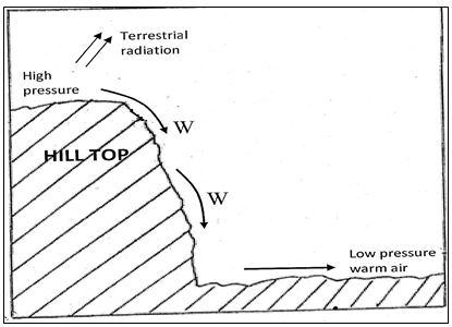
- Identify the type of wind marked W (1 mark)
- List two characteristics of the type of wind marked W (2 marks)
-
- What are limbs in a fold? (2 marks)
- List three theories put forward by scientists on the formation of Fold Mountains. (3 marks)
-
- Distinguish between a seismic focus and epicenter. (2marks)
- Identify three major earthquake belts of the world. (3marks)
-
- Name two warm ocean currents in Africa. (2marks)
- State three factors that influence ocean water temperature. (3marks)
SECTION B (75 MARKS)
Answer question 6 and any other two questions from this section
-
-
- Give the map tittle (2mark)
- Give the longitudinal extent of the area covered by the map (2 marks)
-
- Give the index to adjoining sheet to the North west of the area covered by the map (1mark)
- Convert the scale of the map to statement scale. (2 marks)
- Calculate the area covered by western province. Give your answer in square km (2 marks)
-
- Using a vertical scale of 1cm rep 20m draw a cross section from grid reference 260940 to 320940. (3marks)
On it mark and label the following (4marks)- kadimu Bay
- Road C501/2
- Main Tracks
- thicket
- Calculate the vertical exaggeration (2 marks)
- Using a vertical scale of 1cm rep 20m draw a cross section from grid reference 260940 to 320940. (3marks)
-
- Citing evidence, identify three the social activities carried out in the area covered by the map. (3marks)
- Describe the relief of the area covered by the map. (4marks)
-
-
-
- Name three forces responsible for the shape of the earth (3 marks)
- Give four proofs that the earth is spherical in shape (4 marks)
-
- What is international dateline (2 marks)
- What is the longitude whose local time is 5:00 p.m. when the local time at Longitude 0° is 8:00p.m? (2 marks)
- Use the diagram below to answer the questions that follow.
- What type of eclipse is represented by the diagram how does it occur? (3 mark)
- Name the features marked P and Q (2 marks)
- The diagram below represents the structure of the earth. Use it to answer the questions that follow.
- Name the parts marked A, B and C. (3 marks)
- Give four characteristics of the layer marked B (4 marks)
- Name any two constituents of the atmosphere. (2 marks)
-
-
-
- What is a climax vegetation? (2 mark)
- State four characteristics of the mediterenean type of vegetation (4 marks)
- Explain three factors which influence the distribution of vegetation in Kenya (6 marks)
- Give Reasons why Tundra region has scanty vegetation. (3 marks)
- Write the names of the grasslands found in the following areas (3 marks)
- East Africa
- Canada
- Argentina
- You are required to carry out a field study of the vegetation within the local environment:
- Apart from identifying the different types of plants, state three other activities you will carry out during the field study. (3 marks)
- Give three reasons why it would be necessary to sample out part of the area covered by the vegetation for the study (2 marks)
- List three methods they may have used to collect data (2marks)
-
-
- Distinguish between river regime and river discharge. (2 marks)
-
- State three factors influencing river transport. (3 marks)
- Explain three ways through which a river transports its load. (6 marks)
- With the aid of a well labelled diagram, describe how a river braid is formed. (6 marks)
- Students of Buruburu Girls High School carried out a field study on river rejuvenation on River Athi.
- State three causes of river rejuvenation they found out. (3 marks) (ii) Name any three types of meanders they are likely to have identified. (3 marks)
- Identify two problems they may have encountered during the field study. (2 marks)
-
-
- What is soil? (2 marks)
- Identify two components of soils. (2 marks)
- Differentiate between soil structure and soil texture. (2 marks)
- Name two types of soil according to soil texture. (2 marks)
- Explain how the following factors influence the formation of soil.
- Climate (2 marks)
- Topography (2 marks)
- The diagram below shows a soil catena.
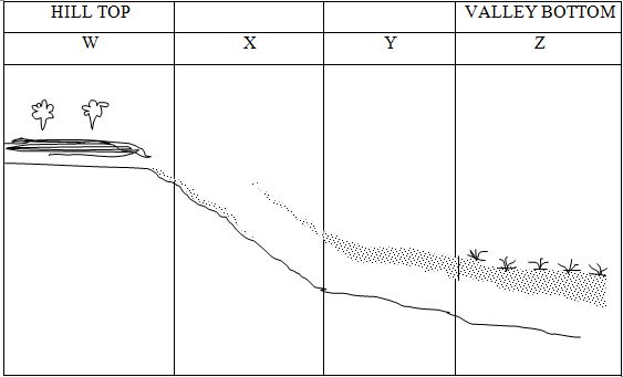
- Name the type of soils found in position W and Z. (2 marks)
- State two characteristics of soils found in section marked W and Z. (4 marks)
- Explain two causes of chemical soil degeneration. (4 marks)
- State three measures of conserving soils. (3 marks)
-
Marking Scheme
-
- What is the relationship between Geography and Medicine. (2 marks)
- Medicine- deals with diagnosis prevention and cure of diseases. Geography is concerned with the factors influencing spread of diseases and the effects on the utilisation of resources
- State three characteristics of Planet Earth. (3 marks)
- Spherical in shape
- Has a force of gravity
- The only planet that supports life
- Has one satellite, the moon
- The surface is covered with 70% water and 30% land
- What is the relationship between Geography and Medicine. (2 marks)
-
- What are harmattan winds. (2marks)
- These are North east winds blowing from Sahara across West Africa between November and March.
- The diagram below shows a type of wind
- Identify the type of wind marked W (1 mark)
- Katabatic wind / mountain breeze
- List two characteristics of the type of wind marked W (2 marks)
- Cold air
- Dense air
- Identify the type of wind marked W (1 mark)
- What are harmattan winds. (2marks)
- Blow from hill top to downhill.
- What are limbs in a fold? (2 marks)
- Rock layers on both sides of the axis that dip (slope) in opposite directions.
- List three theories put forward by scientists on the formation of Fold Mountains. (3 marks)
- Contraction theory
- Continental drift theory
- Plate tectonic theory
- Convectional currents theory
- What are limbs in a fold? (2 marks)
-
- Distinguish between a seismic focus and epicenter. (2marks)
- Seismic focus- a point inside the earth which is the origin of the earthquake shocks while an Epicenter is a point on surface of the earth directly above the seismic focus where the shocks first hit. (2mks)
- Identify three major earthquake belts of the world. (3marks)
- The circum pacific belt/Ring of fire
- Belt across southern Europe and Southern asia
- Along boundaries of tectonic plates
- Distinguish between a seismic focus and epicenter. (2marks)
-
- Name two ocean currents in the Atlantic Ocean. (2marks)
- Agulhas warm ocean current
- State three factors that influence ocean water temperature. (3marks)
- Latitudinal position of the oceans.
- Depth – temperature decreases from surface to bottom. Except at the poles where we have a thin layer of colder water
- Mixing/ upwelling of surface and deep waters
- Name two ocean currents in the Atlantic Ocean. (2marks)
-
-
- Give the map tittle (2mark)
- EAST AFRICA 1:50,000(KENYA/UGANDA
- Give the longitudinal extent of the area covered by the map (2 marks)
- 34000’ to 34015’E
- Give the map tittle (2mark)
-
- Give the index of adjoining sheet to the North East of the area covered by the map (1mark)
- 101/4 UGENYA
- Convert the representative fraction scale of the map to statement scale. (2 marks)
- 50,000÷100,000 = 0.5km2
1cm represents half a kilometer
- 50,000÷100,000 = 0.5km2
- Calculate the area covered by western province. Give your answer in square km (2 marks)
- Full squares =5
- Incomplete squares = 10/2 =5
5+5 = 10km2
- Give the index of adjoining sheet to the North East of the area covered by the map (1mark)
-
- Using a vertical scale of 1cm rep 20m draw a cross section from grid reference 260940 to 320940. (3marks)
On it mark and label the following (4marks)- kadimu Bay
- Road C501/2
- Main Tracks
- thicket
- Calculate the vertical exaggeration (2 marks)
- Using a vertical scale of 1cm rep 20m draw a cross section from grid reference 260940 to 320940. (3marks)
-
- Citing evidence, identify three social activities carried out in the area covered by the map. (3marks)
- Administration - location centres
- Health – Dispensary
- Education -school Maranda
- Describe the relief of the area the area covered by the map. (4marks)
- The highest point in the area covered by the map is 1318m on Ramogi hill
- The eastern part of the map is gently slopping
- The area is hilly
- There are broad river valleys along rivers such as Yala and Ndate
- The region is sloping towards the lake
- Usengi hill has steep slopes
- Yimbo has islands e.g. sifu, Ndede, Mageta (4x1=4mksAny)
- Citing evidence, identify three social activities carried out in the area covered by the map. (3marks)
-
-
-
- Name three fo rces responsible for h=the shape of the earth (3 marks)
- Force of gravity
- Centrifugal force
- Centripetal force
- Give four proofs that the earth is spherical in shape (4 marks)
- If one moves towards the east in a straight line he will end up where he started.
- Satellite photographs taken from space show that the earth is like a sphere.
- Places in the east see the sun earlier than those in the west.
- When a ship is approaching the smoke is seen first, then the mast and finally the whole ship.
- All the planets are spherical so the earth being one of them is also spherical.
- During the moon eclipse the earth casts a spherical shadow on the moon.
- The earth’s horizon appears curved when observed from a very high point like a tower.
- Name three fo rces responsible for h=the shape of the earth (3 marks)
-
- What is international dateline (2 marks)
- It’s the 180◦ longitude and on crossing it one has to adjust their time backwards or forward by 24hrs
- What is the longitude whose local time is 5.00 p.m. when the local time at Longitude 0° is 8.00p.m? (2 marks)
- Difference in time - 3hrs i.e. 3 x 60 = 180 minutes.
- 1 min = 4mins.
- 180 ÷ 4 = 45°
- The longitude is 45° W.
- What is international dateline (2 marks)
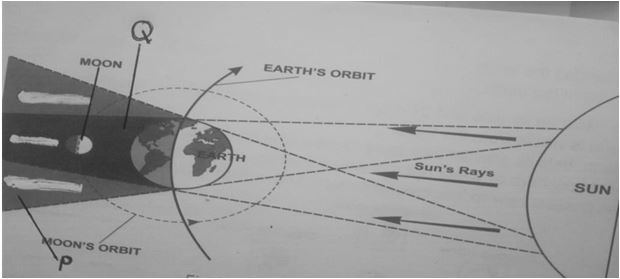
- Use the diagram below to answer the questions that follow.
- What type of eclipse is represented by the diagram how does it occur? (3 mark)
- Lunar/moon Eclipse
- The earth comes between the moon and the sun
- The earth’s shadow is cast on the moon
- The moon appears to be covered by darkness
- Name the features marked P and Q (2 marks)
- P - Penumbra
- Q - Umbra
- What type of eclipse is represented by the diagram how does it occur? (3 mark)
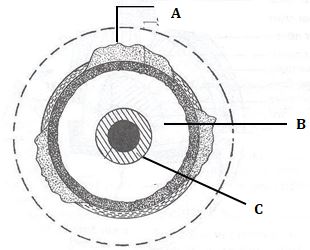
- The diagram below represents the structure of the earth. Use it to answer the questions that follow.
- Name the parts marked A, B and C. (3 marks)
- A – Sial/ Continental crust
- B - Mantle
- C – Gutenberg discontinuity
- Give four characteristics of the layer marked B (4 marks)
- Made of iron and magnesium
- Has two layers
- Density of 3.0- 3.3g/cc
- Thickness of 2900km
- Semi solid state
- Temperature ranges between 1000◦C to 3000◦C
- Name any two constituents of the atmosphere. (2 marks)
- Gases
- Dust particles
- Water vapour/moisture
- Smoke particles
- Name the parts marked A, B and C. (3 marks)
-
-
-
- What is a climax vegetation? (2 mark)
- Natural vegetation that has re-established itself over time such that it becomes well established and reaches a state of equilibrium with exiting environmental conditions
- State four characteristics of the mediterenean type of vegetation (4 marks)
- Forests are open woodlands/widely spaced treees
- Many trees are deciduous.
- Some trees are evergreen e.g. oak
- Tress grow to medium height
- There is woody scrub vegetation in areas which are dry and with poor soils
- Some trees are sweet smelling (aromatic) e.g. rosemary, lavender, oleander, broom and myrtle.
- Many trees are xerophytes (thick barks, waxy leaves, long tap roots, bulbous roots,)
- There are several tree species like olive, sweet chestnut, beech, cedar, cypress, sequoia, eucalyptus
- The vegetation is thick and bushy and grows up to height of between 1.5-3m.
- Some Trees are interlaced with creepers, vines, and herbaceous and bulbous plants.
- Most of this vegetation reflects interference by people.
- What is a climax vegetation? (2 mark)
- Explain three factors which influence the distribution of vegetation in Kenya (6 marks)
- Altitude- There is no vegetation on mountain tops because there are very low temperatures which inhibit plant growth.
- Relief Gentle slopes which have deep and well drained soils are best suited for plant growth than steep slopes which have thin soils due to severe erosion and less soil water to sustain plant growth due to high runoff.
- Aspect - There are a wide range of plants on the slope facing the sun and in the direction of rain bearing winds as they are warm and wetter. The slopes facing the sun tend to be warmer thus support wide variety of plants than slopes facing away from the sun
- Drainage- There is a large variety of plants on well drained soils while water logged soils have swamp plants such as reeds and papyrus.
- Temperature- Plants in warm areas are large in number and grow faster. Also there are deciduous trees which shed leaves to reduce the rate of transpiration.In areas with low temperatures there is slow growth of plants and coniferous forests are found there.
- Precipitation-There are a large number of plants in areas with high precipitation and these areas are dominated by forests which are broad leaved to increase the rate of transpiration.Areas with moderate rainfall are dominated by grasslands and those with little rainfall have scanty vegetation of scrub and desert types.
- Sunlight - There is large number of plants in areas experiencing long sunshine duration.
There is little undergrowth in tropical rain forests because the canopy prevents sunlight from reaching the ground. - Wind - There is heavy rainfall in areas where warm moist wind blows to and hence a large number of plants which may be broad leaved to increase the surface area for transpiration.
Hot dry winds cause drought conditions that lead to scanty vegetation - Edaphic/Soil Factors -Fertile soils have a larger number of plants while infertile soils have scanty vegetation.
- Living Organisms- Bacteria, earth warms and burrowing animals improve soil fertility resulting into more vegetation growth. Large herds of wild animals can destroy vegetation through overgrazing and can turn grasslands into deserts.
- Give Reasons why Tundra region has scanty vegetation. (3 marks)
- The ground is frozen most of the year
- Area has very short growing season/short summer
- The area has thin soils
- Some parts are poorly drained/bog-wet,spongy ground
- Area has low precipitation
- Very strong winds which intefere with seed dispersal (2x1=2mks)
- Write the names of the grasslands found in the following areas (3 marks) (i) East Africa -Savanna
- Canada prairies
- Argentina - Pampas
- You are required to carry out a field study of the vegetation within the local environment:
- Apart from identifying the different types of plants, state three other activities you will carry out during the field study. (3 marks)
- measure /estimate distance /heights
- Collect samples of plants
- Draw sketches /trans-sects
- Record /take notes
- Take photographs of plants/area
- Count plants
- Give three reasons why it would be necessary to sample out part of the area covered by the vegetation for the study (2 marks)
- To save on time
- To get a representation of the whole area
- To cover more areas
- List any two methods they would have used to collect the data (2marks)
- Observation
- interviewing
- Administering questionnaires
- Measuring/
- Collecting Samples
- Photographing
- Sampling
- Apart from identifying the different types of plants, state three other activities you will carry out during the field study. (3 marks)
-
-
- Distinguish between river regime and river discharge. (2 marks)
- River regime is the seasonal variation or fluctuation in the volume of water while river discharge is the amount of water that is passing through a particular point on the river’s course.
-
- State three factors influencing river transport. (3 marks)
- Volume of water – the larger the amount of water in a river, the greater the quantity of load that the river can carry. A small volume of water can only carry a small load.
- Gradient and velocity – A fast flowing river has a greater kinetic energy that a slow one, it can therefore transport more materials. The steeper the gradient, the faster the river can flow and the greater the amount of load a river can carry.
- Nature and amount of load – Small, light particles can be transported over long distances as opposed to large heavier materials which are transported over short distances.
- Describe three ways through which a river transports its load. (6 marks)
- Suspension – lighter materials like mud, silt and clay float on the surface but may periodically be submerged.
- Saltation – large materials carried by river water are moved through a series of short jumps or hops.
- Traction – heavy materials like boulders are pushed and rolled along the river-bed by the force (Hydraulic action) of water and gravity.
- Solution – the load which is dissolved in water is transported in solution form.
- State three factors influencing river transport. (3 marks)
- With the aid of a well labelled diagram, describe how a river braid is formed. (6 marks)
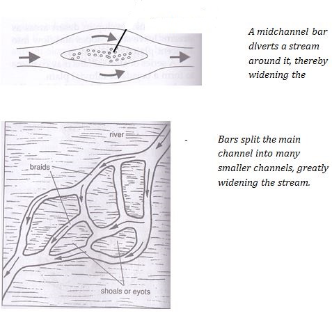
- Along this stage the river is flowing sluggishly at low velocity because of the gentle gradient.
- The river therefore deposits its heavy load on its bed.
- As the deposits accumulate, they form shoals which eventually grow into alluvial islands which raises the river-bed blocking the smooth flow of water.
- The river then becomes subdivided into channels or distributaries in its attempts to flow around the obstacles. This channels are known as river braids.
- Students of Buruburu Girls High School carried out a field study on river rejuvenation on River Athi.
- State three causes of river rejuvenation. (2 marks)
- Change in base level
- Increase in river’s discharge
- A change in rock resistance
- Identify three types of meanders they are k=likely to identify. (2 marks)
- Incised meanders - ingrown(asymmetrical) or intrenched (symmetrical)
- Abandoned meanders
- Identify two problems they encountered during the field study. (2 marks)
- Environmental constraints e.g. heavy rainfall during the study may cut short the fieldwork.
- Transport problem e.g. vehicle in which the students are using may break down.
- The students may face the danger of wild animals such as crocodiles.
- Inaccessibility to some areas due to thick vegetation/swamp
- Difficulty in climbing steep slopes/slippery areas.
- State three causes of river rejuvenation. (2 marks)
- Distinguish between river regime and river discharge. (2 marks)
-
-
- What is soil? (2 marks)
- Soil is the superficial layer of loose/unconsolidated rock materials overlying the crustal rocks and on which plants grow.
or - Soil is an accumulation of rock particles minerals organic matter water and air found on the surface of the earth.
- Soil is the superficial layer of loose/unconsolidated rock materials overlying the crustal rocks and on which plants grow.
- Identify two components of soils. (2 marks)
- Air/gases
- Water/moisture
- Organic matter/humus
- Inorganic matter/minerals
- Differentiate between soil structure and soil texture. (2 marks)
- Soil structure is the way the individual soil particles are arranged into aggregate compound particles while soil texture is the degree of fineness or coarse of the soil particles.
- Name two types of soil according to soil texture. (2 marks)
- Loam soil
- Clay soil
- Sand soil
- Gravel
- Silt
- What is soil? (2 marks)
- Explain how the following factors influence the formation of soil.
- Climate (2 marks)
- Rainfall provide water which make it possible for rocks to decay/disintegrate to form soil.
- Seasonal variation of rainfall can cause accumulation/concentration of salts in soil
- High temperatures increase the rate of weathering/accelerate the rate of bacterial activities which generates some of the organic matter in the soil.
- Topography (2 marks)
- Valley bottoms encourage formation of deep fertile soil due to deposition or weathered materials.
- Steep slopes encourage rapid removal of the top soil thus slowing down formation of soil. Hence they have thin soils or developed soils.
- Flat areas may be saturated with water or are water logged and this slows down soil formation.
- Gently sloping areas have well developed soil because they are well drained.
- Climate (2 marks)
- The diagram below shows a soil catena.
- Name the type of soils found in position W and Z. (2 marks)
- W - Lateritic soils/laterites
- Z - poorly drained Peat/Bog
- State two characteristics of soils found in section marked W and Z. (4 marks)
- W
- Red in colour
- Are acidic soils
- Are rich in iron and alluminium oxides
- Have low humus content/organic matter
- Are sticky soils
- Have developed soil profile
- Are mature soils
- Are of low agricultural value
- Z
- Peat/Bog soils
- Poorly drained soils/water logged
- Grey/blue in colour
- Are acidic
- have poorly developed soil profile
- W
- Name the type of soils found in position W and Z. (2 marks)
- Explain two causes of chemical soil degeneration. (4 marks)
- Monoculture/over cropping leads to exhaustion of soil minerals making it infertile and bare leading to erosion.
- Monoculture leads to loosening of soil particles thereby encouraging soil erosion.
- Continuous application of fertilizer on farm lands increases acidity/increases soil pH thus making it unsuitable for plant growth.
- Continuous application of fertilizers increases acidity of the soil which destroys micro-organisms in the soil which could have helped in the formation of humus.
- Heavy rainfall can cause leaching of certain minerals making the top soil deficient of such minerals.
- Heavy rainfall can cause water logging in the low land areas leading to acidic soils.
- Prolonged drought causes accumulation of mineral salts on the top layer of soils/saline soils.
- State three measures of conserving soils. (3 marks)
- Maintaining soil fertility
- Prevention of soil erosion/loss
- Preservation of the soil.
-
Join our whatsapp group for latest updates
Tap Here to Download for 50/-
Get on WhatsApp for 50/-
Download Geography Paper 1 Questions and Answers - Asumbi Girls High School KCSE Mock 2021.
Tap Here to Download for 50/-
Get on WhatsApp for 50/-
Why download?
- ✔ To read offline at any time.
- ✔ To Print at your convenience
- ✔ Share Easily with Friends / Students


