
Instructions to candidates
- Write your name, admission number and class in the spaces provided above.
- This paper has two sections: A and B
- Answer all the questions in section A
- Answer question 6 and any other two questions from section B
- All answers must be written in the spaces provided after Question 10.
- Candidates should check the question paper to ascertain that all the pages are printed as indicated and that no questions are missing.
For Examiner’s Use Only
|
Section |
Questions |
Candidate’s Score |
Maximum Score |
|
A |
1 – 5 |
|
25 |
|
B |
6 |
|
25 |
|
|
|
25 |
|
|
|
|
25 |
|
|
|
Total Score |
|
100 |
QUESTIONS
'SECTION A
Answer ALL questions in this section.
-
- Name the first two planets of the solar system. (2 marks)
- State three effects of the rotation of the earth on its axis.(3 marks)
- The diagram below shows the angles of the sun’s rays at different altitudes when the sun is overhead at the equator. Use it to answer question (a) and (b).
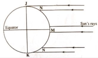
- Name the parts of earth’s surface marked J and K. (2 marks)
- Give two reasons why the intensity of insolation is higher at M than at N. (2 marks)
-
- Identify the temperate grasslands found in the following countries.
- Canada (1 mark)
- Russia (1 mark)
- Australia (1 mark)
- Give two reasons why the Tundra region has scanty vegetation. (2 marks)
- Identify the temperate grasslands found in the following countries.
-
- Identify two sources of water found in a lake. (2 marks)
- Give three ways through which lakes are formed. (3 marks)
-
- Give three factors that determine soil leaching. (3 marks)
- State three ways in which mulching helps in soil conservation. (3 marks)
SECTION B
Answer question 6 and any other two questions from this section.
Study the map of Nyeri 1:50,000 (sheet 120/4) provided and answer the following questions.
-
-
- Identify two map sheets to the eastern part of Nyeri. (2 marks)
- Name two administrative units found in Nyeri. (2 marks)
- Calculate the magnetic declination of the area covered by the map as at 1978. (3 marks)
-
- Give three types of natural vegetation found in the area covered by the map. (3 marks)
- Measure the length of the road D 432 in the southern part from Unjiru junction to Kangaita market. Give your answer in kilometers. (2 marks)
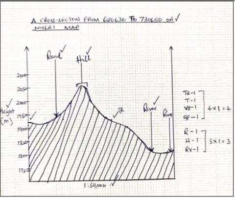
- Using a vertical scale of 1cm to represent 50 metres;
- Draw a cross section from grid reference 680630 to 730650. (4 marks)
- On the cross section, mark and name the following;
- Hill (1 mark)
- River (1 mark)
- Road D 449 (1 mark)
- Citing evidence from the map, identify three economic activities in the area covered by the map. (6 marks)
-
-
-
- Define the term folding. (2 marks)
- Name two fold mountains that were formed during Alpine orogeny. (2 marks)
-
- Apart from fold mountains, give three other features resulting from folding. (3 marks)
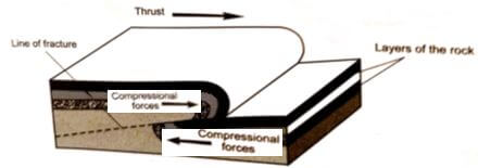
- With the aid of a diagram, describe the formation of an overthrust fold. (6 marks)
- Explain three positive effects of fold mountains on human activities. (6 marks)
- Members of your class are planning to carry out a field study on an area that has undergone folding process.
- Give three ways you would prepare for the study. (3 marks)
- State three advantages of studying landforms through field work. (3 marks)
-
-
-
- What is weathering? (2 marks)
- Apart from plants, give three other factors that influence the rate of weathering. (3 marks)
- Explain two ways in which plants cause weathering. (4 marks)
- Describe the following processes of weathering:
- Block disintegration (4 marks)
- Carbonation (4 marks)
- Explain four effects of mass wasting on the environment. (8 marks)
-
-
-
- Apart from surface run off, give two other processes in the hydrological cycle. (2 marks)
- State three factors that determine the amount of surface run off. (3 marks)
- Explain three factors that influence the transportation of materials by a river. (6 marks)
-
- What is river rejuvenation? (2 marks)
- Explain three conditions that lead to rejuvenation of a river. (6 marks)
- Explain three negative effects of rivers to the human environment. (6 marks)
-
-
-
- What is an ice sheet? (2 marks)
- Explain three factors that influence the movement of ice from the point of accumulation. (6 marks)
- Describe how an arête is formed. (6 marks)
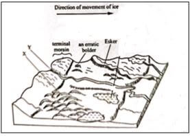
- The diagram below shows features resulting from glacial deposition on a lowland area.
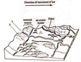
- Name the features marked X and Y. (2 marks)
- Describe how terminal moraine is formed. (3 marks)
- Explain three positive effects of glaciation in lowland areas. (6 marks)
-
GRAPH PAPER

MARKING SCHEME
|
1. (a) |
Name the first two planets of the solar system.
|
1×2=2 marks |
|
(b) |
State three effects of the rotation of the earth on its axis.
|
3×1=3 marks |
|
2. (a) |
The diagram below shows the angles of the sun’s rays at different altitudes when the sun is overhead at the equator. Use it to answer question (a) and (b).
|
2×1=2 marks |
|
(b) |
Give two reasons why the intensity of insolation is higher at M than at N.
|
3×1=3 marks |
|
3. (a) |
Identify the temperate grasslands found in the following countries. (i) Canada – prairies (ii) Russia – steppes (iii) Australia – downs |
3×1=3 marks |
|
(b) |
Give two reasons why the Tundra region has scanty vegetation.
|
2×1=2 marks |
|
4. (a) |
Identify two sources of water found in a lake.
|
2×1=2 marks |
|
(b) |
Give three ways through which lakes are formed.
|
3×1=3 marks |
|
5. (a) |
Give three factors that determine soil leaching.
|
3×1=3 marks |
|
(b) |
State three ways in which mulching helps in soil conservation.
|
3×1=3 marks |
|
6. (a) |
(i) Identify two map sheets to the eastern part of Nyeri.
|
2×1=2 marks |
|
|
(ii) Name two administrative units found in Nyeri.
|
2×1=2 marks |
|
|
(iii) Calculate the magnetic declination of the area covered by the map as at 1978.
|
3×1=3 marks |
|
(b) |
(i) Give three types of natural vegetation found in the area covered by the map.
|
3×1=3 marks |
|
|
(ii) Measure the length of the road D 432 in the southern part from Unjiru junction to Kangaita market. Give your answer in kilometers.
|
1×2=2 marks |
|
(c) |
Using a vertical scale of 1cm to represent 50 metres; (i) Draw a cross section from grid reference 680630 to 730650. |
|
|
|
(ii) On the cross section, mark and name the following;
|
|
|
(d) |
Citing evidence from the map, identify three economic activities in the area covered by the map.
|
3×2=6 marks |
|
7. (a) |
(i) Define the term folding.
|
1×2=2 marks |
|
|
(ii) Name two fold mountains that were formed during Alpine orogeny.
|
2×1=2 marks |
|
(b) |
(i) Apart from fold mountains, give three other features resulting from folding.
|
3×1=3 marks |
|
|
(ii) With the aid of a diagram, describe the formation of an overthrust fold.
Text – 4 marks |
|
|
(c) |
Explain three positive effects of fold mountains on human activities.
|
3×2=6 marks |
|
(d) |
Members of your class are planning to carry out a field study on an area that has undergone folding process
|
3×1=3 marks |
|
|
(ii) State three advantages of studying landforms through field work.
|
3×1=3 marks |
|
8. (a) |
(i) What is weathering?
|
1×2=2 marks |
|
|
(ii) Apart from plants, give three other factors that influence the rate of weathering.
|
3×1=3 marks |
|
|
(iii) Explain two ways in which plants cause weathering.
|
2×2=4 marks |
|
(b) |
Describe the following processes of weathering:
|
4×1=4 marks |
|
|
(ii) Carbonation
|
4×1=4 marks |
|
(c) |
Explain four effects of mass wasting on the environment.
|
4×2=8 marks |
|
9. (a) |
(i) Apart from surface run off, give two other processes in the hydrological cycle.
|
2×1=2 marks |
|
|
(ii) State three factors that determine the amount of surface run off.
|
3×1=3 marks |
|
(b) |
Explain three factors that influence the transportation of materials by a river.
|
3×2=6 marks |
|
(c) |
(i) What is river rejuvenation?
|
1×2=2 marks |
|
|
(ii) Explain three conditions that lead to rejuvenation of a river.
|
3×2=6 marks |
|
(d) |
Explain three negative effects of rivers to the human environment.
|
3×2=6 marks |
|
10. (a) |
(i) What is an ice sheet?
|
1×2=2 marks |
|
|
(ii) Explain three factors that influence the movement of ice from the point of accumulation.
|
3×2=6 marks |
|
(b) |
Describe how an arête is formed.
|
6×1=6 marks |
|
(c) |
The diagram below shows features resulting from glacial deposition on a lowland area. (i) Name the features marked X and Y.
|
2×1=2 marks |
|
|
(ii) Describe how terminal moraine is formed.
|
3×1=3 marks |
|
(d) |
Explain three positive effects of glaciation in lowland areas.
|
3×2=6 marks |
Download Geography Paper 1 Questions and Answers - KCSE 2022 Mock Exams Set 1.
Tap Here to Download for 50/-
Get on WhatsApp for 50/-
Why download?
- ✔ To read offline at any time.
- ✔ To Print at your convenience
- ✔ Share Easily with Friends / Students