
QUESTIONS
SECTION A (25 Marks)
(Answer all questions)
-
- Name two exotic breeds of dairy cattle reared in Kenya. (2mks)
- State three physical conditions that favour dairy farming in Denmark. (3mks)
-
- State two climatic conditions that favour the growing of oil palm in Nigeria. (2mks)
- Give two problems experienced in the marketing of palm oil in Nigeria. (2mks)
- The table below shows petroleum production in thousand barrels per day for countries in the Middle East. Use it to answer question (a)
Country Production in ‘000’ barrels Iran
Kuwait
Qatar
Saudi Arabia
United Arab Emirates
Iraq3,800
2,550
800
9,600
2,000
1,900-
- What is the difference in production between the highest and the lowest producer? (1mk)
- What is the total amount of petroleum produced in April 2006 in the region? (2mks)
- State three conditions that are necessary for the formation of petroleum.
-
- Below is a sketch map showing part of the Great Lakes and St. Lawrence Sea Way. Use it to answer question (a)
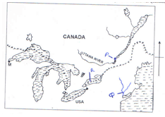
- Name
- The port marked P. (1mk)
- The canal marked Q. (1mk)
- The lake marked R. (1mk)
- State three ways in which great lakes and St. Lawrence Sea Way has contributed to the growth of industries in the region. (3mks)
- Name
-
- Apart from HIV and AIDS, give other causes of mortality in East Africa.
- State two ways in which the spread of HIV and AIDS in Kenya may slow down economic development.
SECTION B (75 MARKS)
(Answer question 6 (compulsory) and any two other questions from this section)
- The table below shows the number of tourists who visited Kenya from various parts of the world in 2005 and 2006. Use it to answer questions (a) and (b).
Place of origin 2005 2006 Europe
Africa
Asia
North America
Australia & New Zealand
All other countries
Total942,000
120,000
97,000
94,000
19,000
29,000
1,301,000965,000
154,000
128,000
103,000
24,000
41,000
1,415,00-
- Which continent had the highest increase in the number of tourist visiting Kenya between 2005 and 2006. (2mks)
- Calculate the percentage increase of the number of tourists from Newzeland and Australia between 2005 - 2006. (2mks)
- Draw a divided rectangle 15cm long to represent the number of tourists 2006. (10mks)
-
- State two advantages of using rectangles to represent geographical data. (2mks)
- Give four reasons why in 2005 and 2006 there were more tourists visiting Kenya from Europe compared to those from other parts of the world. (4mks)
- Give five reasons why domestic tourism is being encouraged in Kenya.
-
-
- State three physical conditions that favour coffee growing in the central Highlands of Kenya. (3mks)
- Describe the stages involved in coffee production from picking to marketing. (8mks)
- Explain four problems facing coffee farming in Brazil. (8mks)
- Your geography class carried out a field study on coffee farm.
- State four methods the class may have used to collect data. (4mks)
- During the field the class collected data on quantities of coffee produced in the farm in the farm in the last five years. State two methods the class may have used to present data. (2mks)
-
-
- Name three places in Kenya where Limestone is mined. (3mks)
- State two uses of trona? (2mks)
-
- The diagram below shows shaft mining. Name the parts marked E, F and G. (3mks)
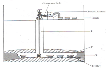
- State two problems associated with shaft mining. (2mks)
- The diagram below shows shaft mining. Name the parts marked E, F and G. (3mks)
- Explain four ways in which gold mining has contributed to the economy of South Africa. (8mks)
- Explain three negative effects of mining on the environment. (6mks)
-
-
-
- What is forestry? (2mk)
- Explain three factors the growth of natural forests on the slopes of Mt. Kenya. (6mks)
- State five factors that have led to the reduction of the area under forests on the slopes of Mt. Kenya. (5mks)
- Explain four measures that the government of Kenya is taking to conserve forests in the country. (8mks)
- Give the differences in the exploitation of softwood forests in Kenya and Canada under the following sub – headings.
- Period of harvesting. (2mks)
- Transportation. (2mks)
-
- The map below shows the location of some urban centres in East Africa. Use it to answer question (a).
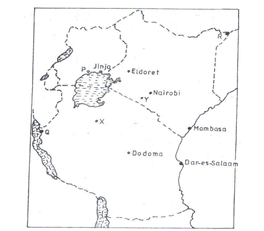
-
- Name the town marked P,Q and R. (3mks)
- Name the minerals that influenced the growth of the town marked X and Y. ( (2mks)
- Explain four factors that have led to the growth of Eldoret as a major town in Kenya.
- Compare the ports of Mombasa and Rotterdam under the following headings
- Site (2mks)
- The hinterland. (2mks)
- Transport links to the interior. (2mks)
- Port facilities. (2mks)
- Explain two negative effects of urbanization on the neighbouring agricultural areas. (4mks)
-

MARKING SCHEME
-
- Fresian
Ayrshire
Guernsey
Jersey
Alderney
Brown swiss
Sahiwall - The landscape is gently sloping which is suitable for grazing.
The climate has warm and sunny summers that allow outdoor grazing.
There is cool climate suitable for pasture growing.
The moderate climate that supports growth of grass/fodder crops.
Builder clay soils support high quality pasture.
- Fresian
-
- High temperatures throughout the year 25ºC to 30ºC.
High rainfall that is evenly distributed throughout the year – 1500 – 2100mm.
High (relative) humidity of 80% to 90%.
Plenty of sunshine during the ripening season. - Competition from other vegetable oils.
Poor road network/impassable roads.
Production of low quality oil.
Reduced production which has lowered the amount of oil exported.
- High temperatures throughout the year 25ºC to 30ºC.
-
-
- 8,800,000 barrels.
- 21,150,000 x 30
6.345 x 08 - 2,550,000 barrels /2.55 x 106
- Deposition of remains of flora and fauna over a long period of time.
Presence of porous rocks.
Presence of non porous rocks underneath the deposit of flora and fauna.
Deposition of other layers of rocks/non porous over the remains of flora and fauna.
Compression of the remains of flora and fauna due to folding of the layers of rocks.
-
-
-
- P - Quebec
- Q - New York State Barge Canal / Erie Canal.
- R - Lake Ontario
- It has increased internal and external trade.
It has facilitated transportation of raw materials and finished products.
It has reduced the cost of transportation of bulky products
The water form dams across the sea provide HEP for industrial use.
It has led to the development of lake ports and towns which provide market/ labour/ housing facilities.
The reservoir provide water for industrial use.
-
-
- Natural calamities./flood /fire
Low nutritional standards/famine/lack of food.
Other epidemics/diseases.
Inadequate medical facilities.
Road carnage.
Attack by bandits - The sickness leads to absenteeism from work/reduced production.
More money used in treating the sick hence reduced purchasing power.
Money spent in treating the sick can be used for other economic activities.
Deaths resulting from the disease lead to loss of economically productive population.
Caretakers at family levels use more time caring for the sick/orphans instead of engaging in economic activities.
- Natural calamities./flood /fire
-
-
- Africa
- 5000×100 = 26.315%
19000 -
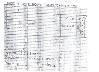
Europe = 965,000 ×15=10.2cm
1,415,000
Africa = 154,000 ×15=1.6cm
1,415,000
Asia = 128,000 ×15=1.4cm
1,415,000
North America = 103,000 ×15=1.0cm
1,415,000
Australia & New Zealand 24,000 ×15=0.3cm
1,415,000
Other countries = 41,000 ×15=0.4cm
1,415,000
(10mk)
-
- They give clear visual impression.
They allow easy comparison.
They can be used to present a wide range of data.
They are easy to interpret.
They are easy to draw. - There are many direct flights from European capitals to Kenya.
There has been aggressive marketing for tourism in Europe.
Europe has had along historical ties with Kenya/good relations.
European countries encourage package tours to Kenya.
Europe has avoided giving negative advisories to tourists wishing to visit Kenya.
- They give clear visual impression.
- To expose Kenyans to a wide variety of recreational facilities.
To make use of tourist facilities during the low tourist seasons./off peak season
To ensure that Kenyans become familiar with different parts of the country.
To make Kenyans appreciate the country’s national heritage/artfacts/ culture/wildlife.
To enable people from different communities to interact to enhance national unity.
To enhance circulation of money within the country/to promote domestic trade.
To create employment in the country.
To raise revenue.
-
-
- The highland experiences high/well distributed rainfall which is ideal to coffee.
The soils are deep fertile volcanic type
The area experiences cool conditions 14 – 24ºC throughout the year.
The land has gentle slopes that allow good drainage/well drained soils. - The ripe/deep red berries are picked by hand.
The harvested berries are carried in the baskets/sacks to the factory.
The berries are sorted out to remove the unripe/diseased berries.
The berries are graded into grade A and B.
The different grades are weighed.
Berries go through a machine that removes the outer covering/pulp/pulping is done.
The beans are fermented in tanks for some time(12hours)
The beans are washed and then sun dried for about a week.
The husks are removed and the beans winnowed.
The beans are sorted out and graded according to size and quality.
The beans are roasted at temperature of about 100ºC.
The beans are ground into powder and bagged ready for sale. - The wasteful techniques of growing the crop leads to soil exhaustion which makes the coffee per hectare low /unregulated cultivation leads to soil exhaustion.
Climatic hazards frost destroys coffee plants reducing the yield.
Unplanned planting leads to overproduction /surplus production which lowers the prices.
The fluctuation of coffee prices in the world market sometimes leads to low profit.
Stiff competition from other coffee producing countries threatens Brazil’s dominance in the world coffee market. -
- Administering questionnaire
Interviewing/asking questions.
Taking photographs/photographing.
Observing/observation
Taking measurements.
Collecting samples.
Counting. - Drawing charts.
Drawing tables.
Drawing graphs.
- Administering questionnaire
- The highland experiences high/well distributed rainfall which is ideal to coffee.
-
-
- Homa Hills
Athi River
Kisumu - Making soap/detergents.
Making fertilizers.
Making glass.
Raw materials in chemical industries.
Making common salts/food additives
- Homa Hills
-
- E Main shaft/vertical shaft.
F – Tunnel /horizontal shaft
G – Mineral ore - Sometimes mines get flooded with subterranean water.
There are occasional emitions of poisonous gases in the mines.
The dust produced causes respiratory disease.
Sometimes tunnels collapse causing deaths of minors.
- E Main shaft/vertical shaft.
- Gold is highly priced, thus it earns foreign exchange when exported which is used to improve other sectors of the economy.
Gold provide raw materials for industries that make jewellery and other highly valued items promoting industrial expansion.
Gold as medium of exchange in the world is used in South Africa as a means of paying international debts.
Gold mining industries has generated employment opportunities which raise the living standard of people.
Gold mining has led to the development of towns in the Rand and the Orange Free State creating a large demand for agricultural products.
Mining of gold has led to the expansion of infrastructure such as transport and communication which have created linkage between the mining towns and other parts of the country.
Gold mining has led to development of industrial mining skills that are useful in other sectors of the economy.
Explain three negative effects of mining on the environment.(6mks) - The dumping of the rock waste has led to the loss of biodiversity /destruction of natural vegetation.
Dereliction of land with dumping of waste materials is eyes sore/destroys the natural beauty of the land.
Pollution of the areas with noise, blasts smoke and water pools are all health hazards.
Mining disrupts the water table which may lead to shortage of water.
Mining takes up land that would have been used for agriculture thus interfering with food production.
Mining displaces human settlements thus disrupting people and necessitating expensive resettlement processes.
-
-
-
- The practice of managing and using trees/forests and their associated resources.
It is the science of planting, caring and using trees/forests and their associated resources. - The area receives high rainfall 1000 – 2000mm throughout the year which encourages the growth of trees.
The area had deep volcanic fertile soils that allow the roots to penetrate deep into the ground to support the trees.
The area has well drained soils thus there is no water logging which cab choke plants and interfere with the growth.
The area is gazetted forest reserve hence settlement and cultivation are prohibited.
The steep slopes discourages human activities thus enabling forests to thrive.
Factor – 1mark
Explanation – 1mark - The illegal encroachment of human activities/illegal cultivation has led to clearing of forests.
Degazettement of some part of the forests
Increased population of elephants /baboons destroy the trees.
Prolonged droughts have caused drying of some trees.
Plant diseases/pests which destroy some trees in the forest.
Outbreak of forest fires/destroy parts of the forest.
Overexploitation of certain species of trees.
- The practice of managing and using trees/forests and their associated resources.
- Registering/recognizing the efforts of NGOs like the Green Belt movement which have mounted campaigns on planting of trees.
Gazetting forested areas to reduce encroachment by the public.
Creating public awareness through mass media /public barazas on the importance of conserving forest resources.
Enacting laws to prohibit the cutting of trees without licence/protecting indigenous trees species.
Establishing NEMA/ministry of environment and natural resources to coordinate environmental management and conservation activities.
Encouraging recycling of paper and other wood based products so as to reduce demand on trees.
Carrying out research through KEFRI and CRAFT in order to come up with ways of controlling diseases and pests /develop species suitable for different ecological regions. -
- In Kenya harvesting is done throughout the year while in Canada harvesting is done in Winter and early Spring.
- In Kenya transportation in mainly by roads while in Canada transportation is mainly by water.
The map below shows the location of some urban centres in East Africa. Use it to answer question (a).
-
-
-
- P – Kampala
Q – Kigoma
K - Mandera - Diamond
Trona/Soda Ash
- P – Kampala
- Eldoret started as a railways station on the Kenya – Uganda railway and thus attracted settlement by the people from around the town.
Eldoret has a rich agricultural hinterland which has led to its growth as an agricultural collecting and processing centre.
It is located in an area that experiences cool and wet climate ideal for settlement.
The terrain of the land is a plateau which allows room for expansion.
The terrain of the land is a plateau which allows room for expansion.
The modern infrastructure such as the international airport have encouraged trade.
Investment by local entrepreneurs/athletes has led to the expansion of the town.
High population in the surrounding region provides market for agricultural manufactured goods/provide labour for the industries.
The government policy of decentralization of industries led to settling up of some industries in the town.
Eldoret is a district headquarter for Uasin Gishu district and this has attracted administrative services in the town. -
- Mombasa is located on the drowned months of rivers Mwachi and Kombeni while Rotterdam is at the mouth of River Rhine.
- Both ports have expansive hinterlands/Mombasa hinterlands extends to DRC/Congo while Rotterdam serves the continental Europe.
- Mombasa relies on road, railway, air and pipeline to the interior while Rotterdam has in addition, River Rhine/canals/Rotterdam is a major transshipment centre.
- Both ports have containerized terminals. Rotterdam has much large warehouse more modernised container serves system/sophisticated port facilities.
- Dumping – the nearby agricultural lands are sometimes used as dumping grounds for the waste generated in the urban centres thus polluting them.
There is conflict in land use as urban centres expand into the land that would otherwise have been used for agriculture.
There is competition for labour as urban centres offer higher wages than agricultural areas.
-
Join our whatsapp group for latest updates
Tap Here to Download for 50/-
Get on WhatsApp for 50/-
Download Geography Paper 2 Questions and Answers - Kakamega Evaluation Mock Exams 2022.
Tap Here to Download for 50/-
Get on WhatsApp for 50/-
Why download?
- ✔ To read offline at any time.
- ✔ To Print at your convenience
- ✔ Share Easily with Friends / Students