
Questions
INSTRUCTIONS TO CANDIDATES
- This paper has two sections A and B
- Answer all questions in section A.
- Answer question 6 and any other two questions from section B.
SECTION A
Answer all question in this section
-
- List down two isothermal layers of the atmosphere. (2mks)
- State any three characteristics of the lowest layer of the atmosphere. (3mks)
-
- Differentiate between faulting and folding. (2mks)
- Apart from Fold Mountains, name three other land forms resulting from folding. (3mks)
-
- What is mass wasting. (2mks)
- Statethree economic benefits of the weathering process. (3mks)
-
- What is soil degeneration?(2mks)
- Identify three types of soil degeneration. (3mks)
-
- Name the type of delta found at the mouth of: [2mks]
- RiverNile
- River Omo
- State one effect for each of the following types of river erosion. (3mks)
- Head ward erosion
- Lateral erosion
- Vertical erosion
- Name the type of delta found at the mouth of: [2mks]
SECTION B
Answer Question 6 And Any Two Questions From This Section.
- Study the map of Nyeri 1:50 000(sheet 120/4) provided and answer the following questions.
-
- Identify two types of scale used in the map. (2mks)
- Give six figure grid reference of trigonometric station 120TT27 in the North Western part of the area covered by the map. (2mks)
-
- Give the longitudinal and latitudinal extend of the area covered by the map. (2mks)
- Measure the length of all-weather road loose surface from Easting 57 to Easting 66. Give your answers in kilometres. (2mks)
- Draw a rectangle 12cm by 16cm to represent the area enclosed by easting 64 and 67 and Northing 51 and 55. in the rectangle, mark the following: (5mks)
- Nyeri Hill Forest
- River Chanya
- Trigometrical Station 120T19
- Kagundu School
- Citing evidence from the map, identify three economic activities carried in the area. (6mks)
- Explain three factors that have influenced settlement in the area covered by the map. (6mks)
-
-
- Define the term Vulcanicity. (2mks)
- Distinguish between Extrusive and Intrusive Vulcanicity. (4mks)
- Give any three resultant features due to intrusive Vulcanicity. (3mks)
- Describe the continental Drift theory. (3mks)
-
- State two artificial causes of earth movement. (2mks)
- Explainany three significance of Vulcanicity to human activities. (8mks)
-
- What is climate? (2mks)
- Explain how the following factors influences climate [9mks]
- Latitude
- Altitude
- Ocean currents
- State four conditions that are necessary for the formation of fog [4mks]
-
- Distinguish between aridity and desertification[2mks]
- State any four causes of aridity and desertification together with their possible solutions. (8mks)
-
- Name two ways ofwater movement in oceans. (2mks)
- List any four types of tides. (4mks)
- State four factors that influence wave transportation. (4mks)
- Form 4 geography class carried out afield study at a wave deposition site at the Coast of Mombasa.
- List any four wave depositional features that might have been observed. (4mks)
- Explain any two factors influencing the type of Coast that they might have studied. (4mks)
- Give any three benefits they might have enjoyed due to conducting reconnaissance to their placeof study. (3mks)
- List two ways the learners might have used in collecting data. (2mks)
- Mention any two types of coral reef they might have studied during the period of their study. (2mks)
-
- Name three major desert found in Africa. [3mks]
- Give two processes in which wind erodes the earth’s surface. (2mks)
- Explain three ways in which wind transports its load. (6mks)
- Using well labeled diagrams, explain how the following desert features are formed.
- Yardangs (5mks)
- Mushroom block. (6mks)
- The diagram below represents features resulting from wind deposition in adesert.Use it to answer questions below;
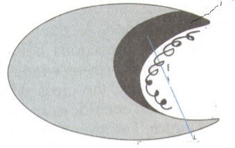
- Name the above feature. (1mk)
- Name the parts marked J and L (2mks)
- Name three major desert found in Africa. [3mks]
Marking Scheme
-
- List down the isothermal layers of the atmosphere (2mks)
- Tropopause
- Stratopause
- Mesopause
- State any three characteristics of the lowest layer of the atmosphere (3mks)
- Temperatures decrease with height.
- Atmospheric pressure decrease with height.
- Speed of wind increase with increase in height.
- Supports life.
- Contains most of the weather making elements.
- List down the isothermal layers of the atmosphere (2mks)
-
- Differentiate between faulting and folding (2mks)
- Faulting is the fracturing /breaking of crustal rocks due to tectonic forces while folding is the bending /crumbling of crustal rocks due to compressional forces.
- Apart from Fold Mountains name three other land forms resulting from folding (3mks)
- Intermontane plateau
- Intermontane basins
- Rolling plains
- Ridge and valley land scape
- Differentiate between faulting and folding (2mks)
-
- What is mass wasting? (2mks)
- Down slope movement of weathered material under the influence of gravity.
- State thee economic benefits of weathering process (3mks)
- Weathering is the process cause break up of parent rocks to form soil used for agriculture
- Weathering produces natural resources e.g clay used for pottery.
- Weathering produce features e.g. granitic tons which attracts tourist
- Weathering weakens the rocks making it easy to exploit through quarrying /mining
- What is mass wasting? (2mks)
-
- What is soil degeneration? (2mks)
- Soil degeneration is the decline in the usefulness of a soil due to soil mismanagement environmental causes or even both
- Identify three types of soil degeneration (3mks)
- Physical degeneration
- Chemical degeneration
- Biological degeneration
- What is soil degeneration? (2mks)
-
- Name the type of delta found at the mouth of (2mks)
- River Nile –Arcuate delta
- River Omo- Birds foot digitate
- State one effect for each of the following types of soil erosion (3mks)
- Head ward erosion – Increase the length of the river valley when the river cuts upstream.
- Lateral erosion –river erodes its banks leading to the widening of the river valley.
- Vertical erosion-takes place at the bed of the river leading to the deepening of the channel.
- Name the type of delta found at the mouth of (2mks)
-
-
- Identify two types of scale used in the map (6mks)
- Linear scale.
- Ration scale / Representative Fraction.
- Give six figures grid reference of Trigonometrical station 120TT27 (2mks)
- 510648,511648,510647
- Identify two types of scale used in the map (6mks)
-
- Give the longitudinal and latitudinal extent of the area (2mks)
- Longitudinal 360 45’E to 37O00’E
- Latitudinal 00 17’S to 00 30’S
- Measure the length of all-weather roads loose surface from easting 57 to 66. Ans in km (2mks)
- -10.1+0.1km(10.0-10.2km
- Draw a rectangle 12x16cm to represent the area enclosed by Easting 64& 67, and Northing 51& 55
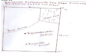
On the rectangle mark and name the following- Nyeri hill forest
- River Chanya
- Trigonometric station
- Kagundu school
- Citing evidence from the map identify 3 economic activity
Economic activity
Transportation
Trade
Coffee processing
Tourism
Quarrying
Cattle keeping
Lumbering
Leather processEvidence
Roads, motorable track
Market shop
Coffee factories
A berdare National park / Ark Lodge/ hotel
Quarries
Monte carlo Ranch
Saw mill
Tannery
- Give the longitudinal and latitudinal extent of the area (2mks)
- Explain three factors that have influenced settlement in areas covered by the map
- Vegetation /forest – forested area in the western parts of Nyeri have no settlement which may be due to attacks by wild animals in the forest.
- Transport- there are many settlements along roads, e.g wanderes road for easy movement of goods and people from one place to another
- There are more settlement within urban centers because of the existence of social amenities such as school, hospital e.g., at Nyeri town
- There are few settlements within the plantation because of the intensive farming in the plantation
- The steep escarpment /slope have been avoided because they are unsuitable for the construction of houses /farming
-
-
- Vulcanicity (2 marks)
- All various ways by which solid liquid and gaseous material are forced into earth’s crust and it’s surface (award any other relevant answer)
- Distinguish extrusive and intrusive vulcanicity (4 marks)
- Extrusive vulcanicity is the process where the material actually breaks through the surface of the earth in a volcanic eruption while intrusive vulcanicity is the process where the material does not have enough strength to break through the surface of the earth.
- Three resultant features due to intrusive vulcanity (3 marks)
- Sill
- Dyke
- Laccoliths
- Batholiths
- Lapoliths
- Phacoliths
- Continental drift theory (6 marks)
- The word was one called Pangea
- Pangea was surrounded by a large water body called Panthallasa
- Pangea broke into two namely Gondwaland and Laurasia. Gondwaland and Laurasia were separated by long long water body called Tethys.Gondwaland drifted to the South and ruptured giving continents such as South America, Australia
- Laurasia drifted to the North and ruptured giving continents such as Eurasia, North America
-
- Two artificial causes of earth movement (2 marks)
- Explosion especially in quarrying sites
- Movement by heavy machines such as railways
- Reservoirs especially in water dammed area
- Three significance of volcanicity to human activities (8 marks)
- Volcanic eruption can cause great loss of life and property
- Volcanic mountains create rain shadow effect resulting to acidity
- Some volcanic lava flows develop into poor soil which are not suitable for agriculture
- Rugged nature and volcanic landscape make settlement and agriculture difficult
- Some volcanic landscape creates barriers which obstruct transport and communication
- Two artificial causes of earth movement (2 marks)
- Vulcanicity (2 marks)
-
- Climate
- Average weather conditions of a given place over a long period of time usually 30-35 years.
- Factors influencing climate under following sub-headings (9 marks)
- Latitude refers to the distance from the equator
- Generally temperature decreases with increase in latitude.
- This is caused by the fact that the insulation received on the earth at the equator is greater and decrease able towards the latitude and also influence the seasonal variation of rainfall due to the changing positions of the inter-tropical convergence zone (ITCZ)
- Altitude
- This affects temperature, rainfall and pressure
- Lowlands are generally warmer than highlands
- Atmospheric pressure is higher at low altitude and low at higher altitudes
- Highlands receives relief rainfall while lowlands receive frontal rainfall
- Ocean current
- warm ocean currents warms up onshore winds building it’s capacity to hold moisture leading to heavy rainfall on coastal land while cold ocean currents rain in the sea, only dry winds reach the coast leading to the occurrence of desert like conditions.
- Latitude refers to the distance from the equator
-
- State four conditions that necessary for the formation of fog (4 marks)
- There must be a clear sky
- There must be sufficient moisture
- The air must be cooled below due point
- The wind must be light/ calm
- Distinguish aridity and desertification (2 marks)
- Aridity is state of insufficient moisture on land leading to scarcity or lack of vegetation and deficiency in soil fertility.Desertification is the encroachment of desert like conditions into formerly productive lands.
- Four causes of aridity and desertification together with possible solutions (8 marks)
- Low and unreliable rainfall of below 250 mmph. Possible solution, irrigating dry lands
- Overgrazing caused by overstocking acceleration of soil erosion, solution-controlling the number of animals kept through putting laws in place. Legislative policies.
- Destruction of vegetation through cultivation, possible solution, afforestation and reafforestation.
- State four conditions that necessary for the formation of fog (4 marks)
- Climate
-
- Ways of water movement in oceans (2 marks)
- Vertical movement
- Horizontal movement
- Four types of tides (4 marks)
- Perigean
- Apigean
- Spring
- Neap
- Factors that influence wave transportation (4 marks)
- Gradient of shore where gentle slopes allow occurrence of long shoredrift and vice versa.
- Strength of waves where strong waves carry large quantities of materials over a long distance and vice versa.
- Nature of the load/weighing of the load
- Presence of ocean currents
(award any well stated point)
-
- Wave depositional features (1x4=4 marks)
- Beaches
- Spits
- Tombolo
- Salt marshes
- Dune belts
- Cuspate foreland
- Factors influencing the types of coast (4marks)
- Tidal currents
- Relative change in the level of land and sea
- Nature of rock, hard rock results of rocks easily eroded
- Human activities, e.g., canals, construction and artificial harbor leading to the alteration of the natural appearance of coast.
- Benefits they might have enjoyed due to conducting a reconnaissance of the place of study (3 marks)
- Assisted in preparing a working schedule
- Helped in proper time management
- Enables familiarization with the area of study
(Award any other relevant points)
- Ways learners might have used in collecting the data (2 marks)
- Through observation
- Through note taking
- Through photographing
(Award any other relevant point)
- Types of coral reef they might have studied during the period of their study (2 marks)Fringing reef
- Barrier reef
- A tool reef
- Wave depositional features (1x4=4 marks)
- Ways of water movement in oceans (2 marks)
-
-
- Major deserts found in Africa (3 marks)
- Sahari
- Kalahari
- Namib
- Processes in which winds erodes the earth’s surface (2 marks)
- Abrasion
- Deflation
- Ways in which wind transports its load (6 marks)
- Saltation –where coarse grained sand particles are transported through series of short jumps/bouncing along the earth surface suspension- very fine materials are picked by wind which raised high and blown for long distance
- Surface creep- heavy materials are rolled/ pushed for short distances along the earth surface
- Major deserts found in Africa (3 marks)
- How the following desert features are formed (5 marks)
- Yardangs
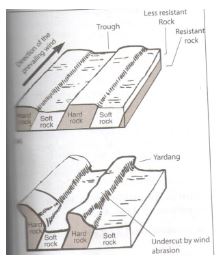
- Prevailing wind blows across the land where there are alternating vertical bands of resistant and non resistant rocks
- Rocks layers lie parallel to direction of the prevailing wind
- Soft rocks are eroded by wind through abrasion/furrows while hard bands of rocks form ridges
- The ridges form features called yardings
- Mushroom blocks
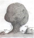
- Formed where there is homogenous rock outcrop along the direction of prevailing winds
- The base of rock is eroded more by wind abrasionThe top part is polished and smoothened through abrasion to form a massive rock with a
- broad rounded top called a mushroom block.
- Yardangs
-
- Barchan (1 mark)
-
- Part marked J –horns (1 mark)
- Part marked L- steep slope (1 mark)
-
Join our whatsapp group for latest updates
Tap Here to Download for 50/-
Get on WhatsApp for 50/-
Download Geography Paper 1 Questions and Answers - Kijiset Revision Mock Exams 2022.
Tap Here to Download for 50/-
Get on WhatsApp for 50/-
Why download?
- ✔ To read offline at any time.
- ✔ To Print at your convenience
- ✔ Share Easily with Friends / Students