
QUESTIONS
SECTION A
Answer all questions in this section
- The diagram below shows the structure of the earth.
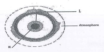
- Name the parts marked K and L. (2 marks)
- Describe the composition of the mantle. (3 marks)
-
- State two factors influencing atmospheric pressure on the earth's surface. (2 marks)
- Describe how a rain gauge is used to measure the amount of rainfall. (3 marks)
- The map below shows climate regions in Kenya. Use it to answer question (a) and (b).
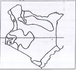
- Name the climatic regions Q and R.(2 marks)
- Give three characteristics of the climate in the region marked R. (3 marks)
-
- Distinguish between block disintegration and exfoliation. (2 marks)
- State three economic benefits of weathering process. (3 marks)
-
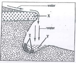
- The diagram below shows a waterfall. Name the parts marked X, Y and Z. (3 marks)
- Give two ways in which a gorge may be formed. (2 marks)
- The diagram below shows a waterfall. Name the parts marked X, Y and Z. (3 marks)
SECTION B
Answer question and any two other questions from this section
-
- Use the map of Nyeri to answer question
- What is the map title?
- Identify two districts found in Nyeri. (2marks)
- Identify index to adjoining sheet found in the Northen and Southern. (2marks)
-
- Name any three types of land transport found in Nyeri. (3marks)
- Name two Physical features found in grid square 6258. (2marks)
- Describe relief of the area covered by the map. (7marks)
- Citing evidence, explain four physical factors which favour cattle keeping. (8marks)
- Use the map of Nyeri to answer question
-
- What is a rock? (2 marks)
- Describe how the following types of rocks are formed.
- Extrusive igneous rocks. (6 marks)
- Mechanically formed sedimentary rocks. (5 marks
- Explain three economic significance of rocks. (6 marks)
- You are planning to carry out a field study on the rocks within your school environment.
- Give three secondary sources of information you would use to prepare for the field study. (3 marks)
- Suppose during the field study you collected granite, lamprohyre and Andesite, classify each sample according to its type of igneous rock. (3 marks)
-
- Differentiate between folding and faulting. (2 marks)
- The table below shows types of folds and faults. For each, identify the type it belongs to
- Asymmetrical - (1 mark)
- Reverse - (1 mark)
- Isoclinals - (1 mark)
- Shear - (1 mark)
- Over thrust - (1 mark)
- Using well labelled diagrams, describe how Fold Mountains are formed. (11 marks)
- Describe how a high fold mountain located at a coastal region influences the formation of rainfall. (7 marks)
-
- Identify three processes of glacial erosion. (3marks)
- Explain how the following influences the rate of glacial erosion. (6marks)
- Speed of glacier
- Weight and thickness of glacier
- Amount of rock materials
- Describe how the following features are formed
- Pyramidal peak. (5marks)
- Hanging valley (6marks)
- Roche montanee (5marks)
-
- Name two types of submerged coasts. (2 marks)
- Explain how the following factors determine the effectiveness of wave erosion along the coast.
- Nature of material transported by waves. (2 marks)
- Nature of coastal rock. (2 marks)
- With the aid of a labeled diagram, describe the processes through which a blowhole is formed. (9 marks)
-
- State four conditions that favour the growth of coral. (4 marks)
- Explain three ways in which coral contributes to the economy of Kenya. (6 marks)
MARKING SCHEME
- The diagram below shows the structure of the earth.
- Name the parts marked K and L.
- K- Inner core
- L - Sial / Continental Crust
- Describe the composition of the mantle.
- It is made up of two parts / upper mantle and lower mantle.
- Lower mantle is viscous fluid.
- Upper mantle is elastic solid / Semi-molten.
- Dominant mineral is olivine / ferro-magnesian silicate.
- The mantle has an average density of 3.0 - 4.0 gms/cc.
- It is 2900 Km thick
- Temp is about 300ºC
- Name the parts marked K and L.
-
- State two factors influencing atmospheric pressure on the earth's surface. (2 marks)
- The altitude of a place on the earth's surface.
- The amount of temperature
- The rotation of the earth
- Describe how a rain gauge is used to measure the amount of rainfall. (3 marks)
- The rain gauge is sunk into the ground and its top being 30cm above the ground level. To avoid surface run off and splashing of water during rainfall.
- The funnel at the top will direct rain water into the cylindrical container containing a glass jar which will collect the rain water.
- The collected rain water will be emptied into a measuring cylinder which will give the amount of rainfall in millimeters for the clay
- State two factors influencing atmospheric pressure on the earth's surface. (2 marks)
- The map below shows climate regions in Kenya. Use it to answer question (a) and (b).
- Name the climatic regions Q and R. (2 marks)
- Q - Tropical Northern
- R - Modified Equatorial y the lake region
- Give three characteristics of the climate in the region marked R. (3 marks)
- Small range of temperature./ 300 5°C.
- Receives rainfall throughout the year.
- Average rainfall is 1000mm
- High temperature av. of 260C
- Double maxima of rainfall.
- Name the climatic regions Q and R. (2 marks)
-
- Distinguish between block disintegration and exfoliation. (2 marks)
- Block disintegration is a process in which blocks of rocks break away from the original rock mass along joints and bedding planes. While ✓
- Exfoliation is a process through which rocks peel off" resulting in the formation of curved rock shells.
- State three economic benefits of weathering process. (3 marks)
- Weathering cause break up of parent rock to form soil used for agriculture.
- Weathering produces natural resources e.g. clay used for pottery.
- Weathering produce features e.g.granitic lohs which attract tourists.
- Weathering weakens the rocks making it easy to exploit through quarrying / mining.
- Distinguish between block disintegration and exfoliation. (2 marks)
-
- The diagram below shows a waterfall. Name the parts marked X, Y and Z (3 marks)
- X - Horizontal layer of hard rock/resistant rock.
- Y - Plunge pool
- Z - Rockyoulders
- Gve two ways in which a gorge may be formed. (2 marks)
- River flowing along a fault line causing deep vertical erosion through fault line.
- Retreating waterfall upstream forming a gorge below the waterfall.
- River flow over a plateau composed of alternating layers of hard and soft rocks
- River rejuvenation/increased in the river's discharge
- The diagram below shows a waterfall. Name the parts marked X, Y and Z (3 marks)
-
- Use the map of Nyeri to answer question 6.
- What is the map title? (1mk)
- East Africa 1: 50,000
- Identify two districts found in Nyeri (2mks)
- Laikipia
- Nyeri
- Identify index to adjoining sheet found in the Northen and Southern. (2mks)
- 120/2- Ongobit
- 134/2- Kangema
- What is the map title? (1mk)
-
- Name any three types of land transport found in Nyeri (3mks)
- all weather road bound surface
- all weather road loose surface
- other track (motorable) check
- . dry weather roads
- Name two Physical features found in grid square 6258. (2mks)
- River
- River valley
- Scrub
- Name any three types of land transport found in Nyeri (3mks)
- Describe relief of the area covered by the map.
- There are over valleys
- The height point is 2800m/ lowest Point 1600M a.s.l
- The forest point is 1600m
- They are gentle slope.
- There are rugged slopes central part
- There are ridges in the southern part
- There are slopes towards the east.
- Citing evidence, explain four physical factors which favour cattle keeping
- Water evidence by may be perennial rivers which the livestock drink.
- Pasture evidenced by forest/ thicket which the livestock feed on.
- Vast lands evidenced by few settlements which provide a large grazing field
- Gentle slopes which are evidenced by widely spaced contours easening mund of livestock.
- Use the map of Nyeri to answer question 6.
-
- What is a rock?
- A substance made a mineral/a combination of minerals particles cemented together forming the solid part of the earth's crust; ✔✔
- Describe how the following types of rocks are formed.
- Extrusive igneous rocks.
- Earth movement leads to the formation of cracks across the earths crust;
- Magma moves through the cracks to the earths surface;✔
- The lava then cools and solidifies forming a hard mass. This is extrusive igneous rock;✔
- Mechanically formed sedimentary rocks.
- Rock particles are derived from pre existing rocks through weathering;
- The particles are transported by water/wind; ✔
- the particles are deposited in layers on land or in the sea bed;
- with time the layers are compacted into a rock by the weight of additional layers;
- Extrusive igneous rocks.
- Explain three economic significance of rocks.
- Rocks weather and form fertile soils which boost crop growing;✓
- Some rock formation create beautiful sceneries which attract tourist thereby earning countries foreign exchange; ✔
- Rocks contain mineral which are mined and exported hence foreign exchange;✓
- Some rocks are curved to make ornaments which are sold hence source of income; ✓
- Rocks are materials for building and construction industry;✔
- You are planning to carry out a field study on the rocks within your school environment.
- Give three secondary sources of information you would use to prepare for the field study.
- Textbooks;
- Class notes;
- Internet;
- Photographs / pictures; /films/slides;
- Geographical maps;
- Suppose during the field study you collected granite, lamprohyre and Andesite, classify each sample according to it's type of igneous rock.
- Granite - plutonic rock;
- Lamphrohyre - hypabyssal rock;
- Andesite - volcanic rock;
- Give three secondary sources of information you would use to prepare for the field study.
- What is a rock?
-
- Differentiate between folding and faulting. (2 marks)
- Folding is the bending of crustal rocks while faulting is the fracturing / cracking of crustal rocks by tectonic forces; (2 marks)
- The table below shows types of folds and faults. For each, identify the type it belongs to (5 marks)
- Asymmetrical - Fault
- Reverse - Fault
- Isoclinals - fold
- Sheer - Fault
- Over thrust - fold
- Using well labelled diagrams, describe how Fold Mountains are formed. (11 marks)
- Extensive shallow depression called a geosynclines develops on the earth's surface;
- Prolonged and extensive erosion occurs on the surrounding higher grounds;
- Sediments are deposited in the geosynclines forming thick layers;
- The weight of the sediments cause subsidence of the geosynclines leading to accumulation of more sediments;
- Further subsidence of the geosynclines triggers off compressional forces;
- The sediments up fold and down fold along the edges of the geosynclines;
- The up folds form fold mountains;
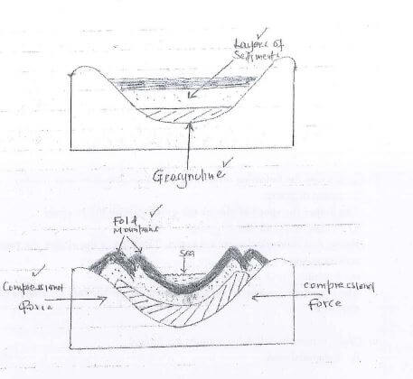
- Text 7 marks;
- Diagram - sediments 1 mark
- Geosynclines 1 mark;
- Compresional forces; 1 mark;
- Fold mountains I mark;
- Describe how a high fold mountain located at a coastal region influences the formation of rainfall. (7 marks)
- During the day, the sea is heated by the sun's rays;
- Evaporation takes place from the sea;
- Warm moist air moves towards the land and rises along the mountain to the higher atmosphere;
- The rising air cools and condenses;
- Clouds are formed;
- Eventually the clouds release rainfall on teh windward slope of the mountain;
- Cold dry wind moves to the leeward side causing little or no rainfall;
- Differentiate between folding and faulting. (2 marks)
-
- Identify three processes of glacial erosion.
- Abrasion
- Plucking
- Nivation
- Explain how the following influences the rate of glacial erosion. (6mks)
- Speed of glacier
- The higher the speed of glacier the greater its ability to erode
- Weight and thickness of glacier (3mks)
- Heavy and thick glacier erodes faster. The thicker the glacier the more erosive power.
- Amount of rock materials
- The larger the amount of rock debris the higher the rate of erosion through abrasion
- Speed of glacier
- Describe how the following features are formed
- Pyramidal peak. (5mks)
- Ice collects on several shallow depressions on the mountain side.
- The hollows are deepened and widened through adrassion and nivation.
- The sides and floor of the depression are attacked by plucking resulting to formation of many cirques
- The back walls retreat towards each other forming arête
- The aretes converge on the mountain top forming steep sided horn shapes ridge called pyramidal peak.
- Hanging valley (6mks)
- Ice occupies a pre-existing main valley and tributery valley
- The main valley and tributary valley are glacially eroded through abrasion and plucking
- More erosion is experienced on the main valley than the tributary valley
- The main valley is deepened and widened through vertical and lateral erosion forming glacial trough.
- The eroded tributary valley remains suspended on the upper edge of the main valley.
- This forms the hanging valley.
- Roche montanee
- Glacier comes across a resistant rock out crop in a lowland (5mks)
- the upstream side is polished by abrasion making it smooth
- The downstream side is eroded by plucking making it steep
- Eventually a resultant rock with smooth upstream and rugged downstream is formed
- This is a roche montanee
- Pyramidal peak. (5mks)
- Identify three processes of glacial erosion.
-
- Name two types of submerged coasts. (2 marks)
- Ria;
- Fiord:
- Dalmatian : longitudinal;
- Estuarine;
- Explain how the following factors determine the effectiveness of wave erosion along the coast.
- Nature of material transported by waves. (2 marks)
- Hard rocks carried by the waves increase erosion by abrasion:
- Nature of coastal rock. (2 marks)
- Soft coastal rocks are easily worn away by waves/ materials carried by the waves,
- Jointed rocks enhance effective erosion;
- Coastal rock which are soluble are eroded through solution process.
- Nature of material transported by waves. (2 marks)
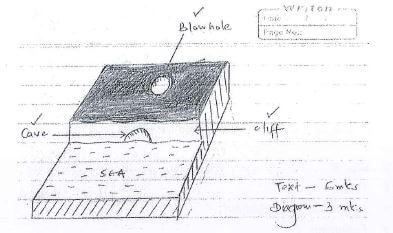
- With the aid of a labeled diagram, describe the processes through which a blowhole is formed. (9 marks)
- The base of a cliff is attacked by wave abrasion forming a notch:
- Continued wave action enlarges the notch into a cave;
- Wave action erodes a line of weakness at the back of the cave roof towards the surface;
- Weathering through solution enlarges the line of weakness from the surface towards the cave;
- Eventually a near vertical shaft connecting the surface to the cave below is formed;
- This is a blow hole;
-
- State four conditions that favour the growth of coral. (4 marks)
- The water should be warm/20° -30°C;
- The water should be shallow /depth of 60m:
- The water should be clear / free from sediments;
- There should be plentiful supply of planktons:
- The water should be well oxygenated;
- Explain three ways in which coral contributes to the economy of Kenya. (6 marks)
- Coral features attract tourists who bring foreign exchange into the country:
- * Coral reefs provide breeding grounds for fish. This has promoted fishing industry at the cost:
- Coral rocks provide limestone which are used as a raw material for making cement;
- Coral rocks provide stones which are used in building industry:
- Coal stones are extracted and sold as ornaments;
- State four conditions that favour the growth of coral. (4 marks)
- Name two types of submerged coasts. (2 marks)
Join our whatsapp group for latest updates
Tap Here to Download for 50/-
Get on WhatsApp for 50/-
Download Geography Paper 1 Questions and Answers - Mangu High School Mock Exams 2022.
Tap Here to Download for 50/-
Get on WhatsApp for 50/-
Why download?
- ✔ To read offline at any time.
- ✔ To Print at your convenience
- ✔ Share Easily with Friends / Students