
QUESTIONS
SECTION A.
-
- What is a solar system? (2marks)
- Give THREE components of the solar system. (3 marks)
- The diagram below shows the angles of the Sun’s rays at different latitudes when the sun is at the equator. Use it to answer questions (a) and (b)
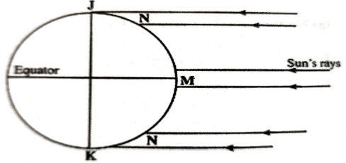
- Name the parts of the earth’s surface marked J and K. (2 marks)
- Give two reasons why the intensity of the insolation is higher at M than at N. (2 marks)
-
- Name TWO types of faults. (2 marks)
- Explain any TWO processes that causes faulting. (4 marks)
-
- Identify the types of vegetation in the following areas. (2 marks)
- State THREE characteristics of Savanna vegetation in Kenya. (3 marks)
- Study the diagram below and use it to answer the questions that follow
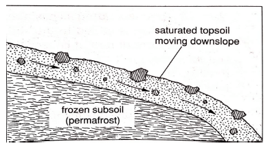
- Identify the process above (1 mark)
- Describe how the process above takes place. (4 marks)
SECTION B: (75 MARKS)
-
-
- What type of map is Nyeri sheet? (1 mark)
- Identify TWO districts found in the area covered by the map. (2 marks)
- Citing evidence state TWO functions of the area covered by the map. (4 marks)
-
- Explain TWO factors that favour trade in the area covered by the map. (4 marks)
- Describe the relief of the area covered by the map. (5 marks)
-
- Draw across-section between trigonometric station at 6963 and grid reference 7561. Use scale. 1cm rep 40m. mark and label
- Amboni farm (1 mark)
- River (1 mark)
- Kimenju estate (1 mark)
- Calculate vertical exaggeration. (2 marks)
- Draw across-section between trigonometric station at 6963 and grid reference 7561. Use scale. 1cm rep 40m. mark and label
-
-
-
- What is a rock? (2 marks)
- Give TWO examples of plutonic igneous rocks. (2 marks)
- Describe the process of formation of the following types of sedimentary rocks.
- Mechanically formed (4 marks)
- Organically formed (4 marks)
- State FIVE characteristics of rocks. (5 marks)
- Form Four Geography candidates of Maseno School are planning to carry out a field study on rocks within their environment
- List THREE methods they will use to record data. (3 marks)
- Identify TWO items that they will carry during the study. (2 marks)
- State THREE follow-up activities they will get involved in after the study. (3 marks)
-
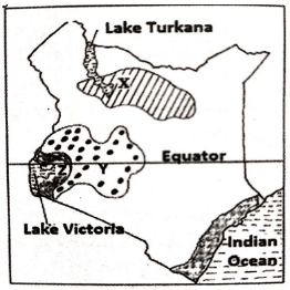
- The map below shows some climatic regions of Kenya. Use it to answer question (a)
-
- Name the climatic regions marked X,Y. (2 marks)
- State THREE characteristics of the climatic region marked Z. (3 marks)
- Explain how the following factors influences climate
- Altitude (2 marks)
- Ocean currents (2 marks)
- Latitude (2 marks)
- What are the negative effects of climate change on the physical environment (4 marks)
- The table below shows rainfall and temperature figures of a station in Africa
Month J F M A M J J A S O N D Temp (°C) 24 24 23 22 19 17 17 18 19 20 22 23 Rainfall (mm) 109 122 130 76 52 34 28 38 70 108 121 120 - Calculate the annual temperature range of the station above. (2 marks)
- Calculate the mean annual rainfall. (2 marks)
-
- Differentiate between aridity and desertification. (2 marks)
- State FOUR possible solutions to aridity and desertification (4 marks)
-
-
-
- Name TWO types of submerged highland coasts. (2 marks)
- Identify TWO resultant features of the emerged highland coasts. (2 marks)
-
- Explain THREE factors that determine the rate of coastal erosion. (6 marks)
- Identify TWO features found at the beach. (2 marks)
- State THREE conditions necessary for the formation of a beach. (3 marks)
-
- Using a well labelled diagram(s), describe how a bay bar is formed. (6 marks)
- State FOUR ways in which corals contribute to the economic development of Kenya.(4 marks)
-
-
-
- What is glacier? (2 marks)
- Name TWO types of glacier. (2 marks)
- Explain TWO process which the glacier erodes. (4 marks)
-
- Describe the formation of a crag and tail. (4 marks)
- The diagram below shows features resulting from glacial deposition in lowland area.

Name the features marked X, Y,Z (3 marks) - Explain TWO positive effects of glaciation in lowland areas. (4 marks)
-
- Students from your school are planning to carry out field study. Give reasons why they would require a working schedule. (3 marks)
- Give THREE reasons why it would be difficult for the students to undertake field study on the glaciated features on top of the mountain. (3 marks)
-
Join our whatsapp group for latest updates
Tap Here to Download for 50/-
Get on WhatsApp for 50/-
Download Geography Paper 1 Questions - Maseno Mock Examinations 2022.
Tap Here to Download for 50/-
Get on WhatsApp for 50/-
Why download?
- ✔ To read offline at any time.
- ✔ To Print at your convenience
- ✔ Share Easily with Friends / Students