
QUESTIONS
SECTION A
Answer all questions in this section
-
- Name the biggest planet in the solar system. (1mk)
- State three characteristics of the core. (3mks)
-
- Define the following terms.
- Dew point (1mk)
- Temperature inversion (1mk)
- Identify three sources of carbon dioxide in the atmosphere. (3marks)
- Define the following terms.
-
- State three causes of earth movements. (3mks)
- Name two main earthquake zones in the world. (2mks)
- The diagram below shows a an example of a local wind
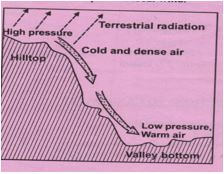
- Identify the local wind . (1mk)
- Describe how the wind is formed. (4mks)
-
- Identify two sources of underground water. (2mks)
- State three conditions that favour the formation of artesian walls. (3mks)
SECTION B
Answer question 6 and any other two questions from this section
- Study the map of Oyugis 1:50000 [sheet index 130/1] provided and answer the following questions
-
- Give the four figure grid reference of the trigonometrical station at Matieka (2mks)
- Identify three man made features in the grid square 7628. (3mks)
- Identify the adjoining sheet to the North –east of Oyugis (1mk)
- Draw a rectangle measuring 12cm by 8cm to enclose the area between northings 23 and 25 and between eastings 70 and 73 (2mks)
On the rectangle, mark and label the following- River Nyamaura (1mk)
- All weather loose surface road (1mk)
- Bridge/bridges (1mk
- forest . (1mk)
-
- Describe the drainage of the area covered by the map. (5mks)
- Describe the relief of the area covered by the map. ( 5mks)
- Identify three social functions found in the area covered by the map. (3mks)
-
-
-
- What is fog. (2mks)
- State two conditions necessary for the formation of fog. (2mks)
-
- With the aid of a labeled diagram, describe how relief rainfall is formed. (7mks)
- Use the map of Africa below to answer the questions that follows.
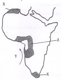
Name- Type of climate experienced in the region marked X. (1mk)
- The ocean current marked Y. (1mk)
- Describe the characteristics of the type of climate found in shaded area marked Z. (4mks)
- Suppose your class carried out a field study on weather around the school environment
- Explain two effects of wind on climate that they are likely to have identified. (2mks)
- Give two methods that you used to collect data in the field. (2mks)
- Give two follow up activities that you were involved in after the field study. (2mks)
-
-
-
- Differentiate between a watershed and a confluence. (2mks)
- Describe two processes though which a river erodes its channel . (4mks)
- The diagram below shows a water fall. Use it to answer question b (i)
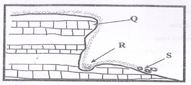
- Name the parts marked Q, R and S. (3mks)
Q – (1mk)
R – (1mk)
S – (1mk) - Explain two causes of river rejuvenation. (1mk)
- Name two features resulting from river rejuvenation. (2mks)
- Name the parts marked Q, R and S. (3mks)
- Using well –labeled diagrams, describe how an ox-bow lake is formed. (6mks)
- Your Geography class intends to carry out a field study on an ox-bow lake a long river Yala. Give four reasons for dividing the class into groups. (4mks)
-
-
-
- Define the term faulting. (2mks)
- Name three featured formed as a result of faulting. (3mks)
-
- State three characteristics of the Gregory Rift Valley. (3mks)
- Give three theories that explain the origin of the Rift Valley. (3mks)
- Explain four ways in which faulting influence drainage. (8mks)
- A form 4 geography class of Mwarano High School carried out a field study on the section of the Rift Valley in Kenya.
- State three preparations they had before the study. (3mks)
- State three ways of data recording activities used during the study. (3mks)
-
-
-
- Define the term soil. (2mks)
- Name two types of soil according to texture. (2mks)
- Briefly explain how the following factors influence soil formation.
- Climate (4mks)
- Living organisms. (4mks)
-
- Differentiate between soil profile and soil catena. (2mks)
- List three processes which influence the development of soil profile. (3mks)
- Explain how the following human activities lead to soil erosion.
- Continuous ploughing (2mks)
- Cutting down trees. (2mks)
- Identify four consequences caused by severe soil erosion in an area. (4mks)
-
MARKING SCHEME
Answer all questions in this section
-
- Name the biggest planet in the solar system. (1mk)
Jupiter - State three characteristics of the core. (3mks)
- It is made of two parts/ inner core and outer core
- Outer core is made up molten rocks
- The inner core is solid
- It is made up of iron and nickel
- Temperature ranges from 3700oC to 6000oC
- Average denity ranges from 10gm/cc to 15gm/cc
( 3 x 1 = 3marks )
- Name the biggest planet in the solar system. (1mk)
-
- Define the following terms.
- Dew point (1mk)
This is the temperature at which the moisture in the atmosphere changes into liquid state. (1mark) - Temperature inversion (1mk)
A phenomena where temperature increases with increasing altitude in the atmosphere. (1mk)
- Dew point (1mk)
- Identify three sources of carbon dioxide in the atmosphere. (3marks)
- Burning of wood fuel/petroleum
- emission from volcanic eruptions
- photosynthesis
3 x 1 = 3 marks.
- Define the following terms.
-
- State three causes of earth movements. (3mks)
- Isostatic adjustment
- Convectional current in the mantle
- Gravitative pressure
- Magma movement within the crust.
3 x 1 = 3 marks
- Name two main earthquake zones in the world. (2mks)
- The pacific belt
- The Mid-atlantic Ridge
- Rift valley Medirerranean – Hamalayan belt
2 x 1 = 2marks
- State three causes of earth movements. (3mks)
- The diagram below shows a an example of a local wind
- Identify the local wind. (1mk)
- Katabatic wind
1 x 1 = 1mark
- Katabatic wind
- Describe how the wind is formed. (4mks)
- During the night, hill tops and mountain slopes are cooled faster compared to the valley bottoms by terrestrial radiation.
- air at the hill tops and valley slopes become denser thereby increasing in pressure while the air below the valley is warmer and of low pressure
- air at the valley bottom remain warmer and rises causing low pressure.
- the cold dense air on the upper slopes flow down by gravity as katabatic wind
4 x 1 = 4marks
- Identify the local wind. (1mk)
-
- Identify two sources of underground water. (2mks)
- River water
- Lakes and sea water
- Rivers
- Melt water
- Magmatic water
2 x 1 = 2 marks
- State three conditions that favour the formation of artesian walls. (3mks)
- The aquifer must be sandwiched between impermeable rocks so that it can retain water.
- the aquifer must outcrop in a region which is source of water e.g. rainy area
- The aquifer must outcrop in a region which is a source of water e.g. rainy area.
- The aquifer must dip from a region of water intake and the rock layers must form a broad syncline basin.
- The mouth of the well must be lower than the intake area to allow water to be forced to the surface pressure.
3 X 1 = 3 marks
- Identify two sources of underground water. (2mks)
- Study the map of Oyugis sheet index 130/1 provided and answer the following questions
-
- Give the four figure reference of the trigonometrical station at Matieka (2mks)
- 9036
- Identify three man made features in the grid square 7628 (3mks)
- All weather loose surface road
- Kuna dam/dam
- Settlement units/market
3 x 1 = 3 marks
- Identify the adjoining sheet to the North –east of Oyugis (1mk)
- yakach 116/4
- Give the four figure reference of the trigonometrical station at Matieka (2mks)
- Draw a rectangle measuring 12cm by 8cm to enclose the area between northings 23 and 25 and between eastings 70 and 73 (2mks)
On the rectangle, mark and label the following- River Nyamaura
- All weather loose surface road (1mk)
- Bridge/bridges (1mk)
- forests (1mk)
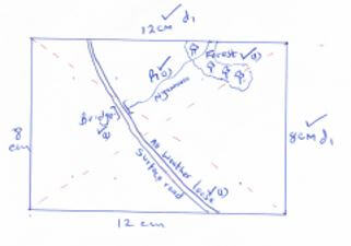
Total (6 marks)
-
- Describe the drainage of the area covered by the map. (5mks)
- The main rivers draining the areacoverd by the map are Riana ,Awachtende ,Maungo
- There many rivers draining the area covered by the map
- Most rivers in the area are permananent
- The rivers and the tributaries have formed dendritic drainage patterns
There is a seasonal river in the area covered by the map [grid square 7528] - There is a swamp in the area
- The main river [RIANA]FLOWS SOUTH WESTWARDS
- River Riana has meanders
5 x 1 = 5 marks
- Describe the relief of the area covered by the map. (5mks)
- The relief of the area has been disected by river valleys
- the land rises from east to Westwards and northwards
- the lowest point is 3950ft above sea level
- The area has hills e.g. Ingeli
- The western part is low lying
- The eastern part is generally hilly
- There are river valleys
5 x 1 = 5 marks
- Identify three social functions found in the area covered by the map. (3mks)
- Securityeg PP
- Educationegsch
- Healthcare/medical careegdisp
- Administrationeg chiefs office
3 x 1 = 3 marks
- Describe the drainage of the area covered by the map. (5mks)
-
-
-
- What is fog. (2mks)
- is a mass of water droplets which are suspended in the lower atmosphere and reduces visibility to less than a kilometer. (2 marks)
- State two conditions necessary for the formation of fog. (2mks)
- Abundant moisture in the air
- Air must be cooled below drew point
- The wind must be light/calm
- There must be clear sky/ absence of clouds (to permit free terrestrial radiation
2 x 1 = 2 marks
- What is fog. (2mks)
-
- With the aid of a well labeled diagram, describe how relief rainfall is formed. (7mks)
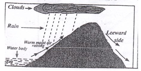
- A water body /seal lake is heated causing evaporation of water
- Moist air from the sea is formed to ascend a hill/mountain side
- Forced ascend leads to expansion and cooling air.
- The moisture in the air condenses forming clouds.
- Rain then falls mainly on the windward side of the hill/mountain
- Diagram 2 marks
- Text 5 marks
- Total 7 marks
- With the aid of a well labeled diagram, describe how relief rainfall is formed. (7mks)
- Use the map of Africa below to answer the questions that follows.
Name- Type of climate experienced in the region marked X. (1mk)
- Mediterranean (1 mark)
- The ocean current marked Y. (1MK)
- Cold Benguela current. (1 mark)
- Describe the characteristics of the type of climate found in shaded area marked Z. (4mks)
- Moderate rainfall/750 – 1000mm
- Rainfall is mainly convectional and the falls during the hot season
- The cool season is generally dry
- Rainfall amounts decrease in places away from the equator
- High temperatures throughout the year (21º – 32ºC.)
- Annual range of temperature is high /11ºC
- There are two distinct seasons, a cool season and a dry season.
- The prevailing winds are mainly the trade winds.
4 x 1 = 4 marks
- Type of climate experienced in the region marked X. (1mk)
- Suppose your class carried out a field study on weather around the school environment
- Explain two effects of wind on climate that they are likely to have identified. (2mks)
- Winds from a warm region raise temperatures of the area they blow to.
- Winds from a cold region lower temperatures of the area they blow to.
- Winds passing over a moist region pick moisture causing high rainfall in area they blow to.
- Winds passing over a dry region remain dry causing dry conditions over the areas they blow to.
2 x 2 = 4 marks
- Give two methods that you used to collect data in the field. (2mks)
- Observation
- Photographing
- Administering questionnaires
- Counting
2 x 1 = 2 marks
- Give two follow up activities that you were involved in after the field study. (2mks)
- Reading more on the topic
- Displaying photographs
- writing reports
- discussing with the rest of the class
- Analyzing the information collected
- drawing diagrams
2 x 1 = 2 marks
- Explain two effects of wind on climate that they are likely to have identified. (2mks)
-
-
-
- Differentiate between a watershed and a confluence. (2mks)
- A water shed is a ridge/ highest area separating two river channels/basin/valleys while a confluence is the point where river tributaries join the main river. (2 marks)
- Describe two processes though which a river erodes its channel. (4mks)
- Abrasion/corrosion is an erosion process where the river water uses the bad/materials it is transporting to scrub, polish, grid the river banks and the river bed.
- Solution – Solution is the process where as a river flows it dissolves soluble minerals and salts from the river bed and river banks
- Hydraulic action/quarrying – process where the shear force of the water as it flows is thrown to the cracks of rocks of the river bed and banks crating pressure causing cracking
- Attrition – Eroded particles collide with each other hence reducing in sizes.
Process – 2 marks
Description – 2 marks
Total – 4 Marks
- Differentiate between a watershed and a confluence. (2mks)
- The diagram below shows a water fall. Use it to answer question b (i)
- Name the parts marked Q, R and S. (3mks)
- Q – Resistant rock (1mark)
- R –Plunge pool (1mark)
- S – Rock boulder/debris (1mark)
- Explain two causes of river rejuvenation. (1mk)
- Increase in the river discharge/volume (static rejuvenation caused by increased rainfall in the catchments area, river capture or melt of glacier causing the river to renew its erosive power.
- Changes in the base level (dynamic rejuvenation) may be caused by uplift or subsidence of land causing the river to renew its erosive power
- Change in rock resistance from hard to soft increasing the river’s erosive power.
- Name two features resulting from river rejuvenation. (2mks)
- Abandoned meanders
- Knick points
- River terraces
- Incised meanders/ingrown meanders/in trenched meanders.
2 x 1 = 2 marks
- Name the parts marked Q, R and S. (3mks)
- Using well –labeled diagrams, describe how an ox-bow lake is formed. (6mks)
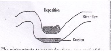
- The river starts to meander from one end of the valley to the other .
- The river deposits in the inner bank and erodes the outer bank.
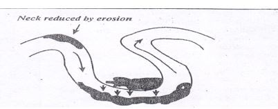
- continued erosion and deposition leads to the formation of a pronounced meander to form a neck / narrow land
- With time the river erodes off the meander neck to form a short cut abandoning the former long channel
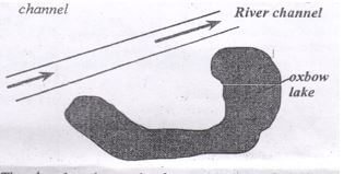
- The abandoned meander forms a crescent shaped water body known as Ox-bow lake
Diagrams – 3 marks
Description – 3 marks
- Your Geography class intends to carry out a field study on an ox-bow lake a long river Yala. Give four reasons for dividing the class into groups. (4mks)
- It creates order
- To cover a wide area within a short time
- To avoid overcrowding and injuries
- To ensure maximum participation of all students.
-
-
-
- Define the word faulting. (2mks)
- It is the fracturing of the crustal wals of the earth, by the vertical movement on either side of the fracture. (2marks)
- Name three featured formed as a result of faulting. (3mks)
- Faults
- Rift valleys
- Block /horst mountains/fault blocks
- Tilt blocks
- escarpment/fault scrarps
3 x 1 = 3 marks
- Define the word faulting. (2mks)
-
- State three characteristics of the Gregory Rift Valley. (3mks)
- The width varies from place to place
- The width of the escarpment varies
- Has uneven floor
- Has numerous lakes on its floor
- Has volcanic mountains e.g. Suswa and Longonot
3 x 1 = 3 marks
- Give three theories that explain the origin of the Rift Valley. (3mks)
- By compressional theory
- By tension theory
- By Anti-clinal arching theory
3 x 1 = 3 marks)
- Explain four ways in which faulting influence drainage. (8mks)
- When faulting occurs across a river the displacement of land can form a water fall hence river rejuvenation.
- Rift valleys form a basin where water collects to form a lake.
- Land uplifting due to faulting may change rivers direction.
- Some rivers may flow along a fault line- fault guided drainage patterns.
- State three characteristics of the Gregory Rift Valley. (3mks)
- A form 4 geography class of Mwarano High School carried out a field study on the section of the Rift Valley in Kenya.
- State three preparations they had before the study. (3mks)
- Got permission from the school administration on the intended visit
- Researched on secondary sources like books journals.
- Assembled necessary equipment like note books, pens and cameras
- Formulated objectives/hypotheses for the study.
- Prepared questionnaires.
- Prepared working schedule
- Carried out a reconnaissance/pre-visit.
3 x 1 = 3 marks
- State three ways of data recording activities used during the study. (3mks)
- Tape recording
- Taking photographs/video recording
- Filling questionnaires
- Taking notes
- Drawing maps/Sketches
3 x 1 = 3 marks
- State three preparations they had before the study. (3mks)
-
-
-
- Define the word soil. (2mks)
- Soil is the uppermost surface layer of unconsolidated material which lies on the surface of the earth and in which plant grow. (2 marks)
- Briefly explain two types of soil according to texture. (2mks)
- Loam
- Silt
- Clay
- Sand Gravel
2 x 1 = 2 marks
- Define the word soil. (2mks)
- Briefly explain how the following factors influence soil formation.
- Climate (4mks)
- Rainfall provides the moisture required for rocks to weather chemically and eventually form soils.
- Rainfall affects the rate at which some land forming processes such as leaching can occur.
- High temperatures increase the rate of weathering and also accelerate the rate of bacterial activity which generates some organic matter in the soil.
- Climate influences the process of erosion by water, Wind and ice.
2 x 2 = 4 mark
- Living organisms. (4mks)
- The assist in breaking down the rock through burrowing, ploughing and root penetration
- They influence the chemical composition by adding/removing organic acid solution/minerals.
- Burrwoing/digging influence soil aeration.
- Climate (4mks)
-
- Differentiate between soil profile and soil catena. (2mks)
- Soil profile is vertical arrangement of different layers of soil from the surface to the bedrock while soil catena is the sequence of different soils down a slope on the surface of the land. (2 marks)
- List three processes which influence the development of soil profile. (3mks)
- Podzolization
- Salinization
- Solodization
- Calcification
- Ferrolization
3 x 1 = 3 marks
- Differentiate between soil profile and soil catena. (2mks)
- Explain how the following human activities lead to soil erosion.
- Continuous ploughing (2mks)
- Continuous ploughing weakens the soil structure making it easy to the agent of erosion to carry it away. (2 marks)
- Cutting down trees. (2mks)
- Cutting down trees exposes the soil to the agents of soil erosion s the ground is left bare. (2 marks)
- Continuous ploughing (2mks)
- Explain two consequences caused by severe soil erosion in an area. (2mks)
- The productive topsoil is lost forever and only unproductive stony soil is left behind. This reduces agricultural productivity of the land.
- When gullies are deepened to the water table underground water is exposed. Some water flows out as stream while the rest evaporates, hence water is lowered leading to scarcity of water
- Eater reservoir gets silted reducing their capacity and affecting their efficiency in H.E. P production. Reducing the amount of water available for irrigation.
- Soil water washed into water bodies contains agro-chemicals that are harmful to aquatic life.
2 x 2 = 4 marks.
-
CONFIDENTIAL
- provide a map of Oyugis
Join our whatsapp group for latest updates
Tap Here to Download for 50/-
Get on WhatsApp for 50/-
Download Geography P1 Questions, Answers and Confidential - Mangu High School Trial Mock Exams 2021/2022.
Tap Here to Download for 50/-
Get on WhatsApp for 50/-
Why download?
- ✔ To read offline at any time.
- ✔ To Print at your convenience
- ✔ Share Easily with Friends / Students


