
QUESTIONS
SECTION A
Answer all the questions in this section.
-
- State three effects of the rotation of the earth on its axis. (3 marks)
- Give two proofs that the earth is spherical. (2 marks)
-
- State three factors that influence how the wind blow(3 marks)
- Identify two types of local winds. (2 marks)
-
- Identify two characteristics of minerals. (2 marks)
- Give three classifications of mechanically formed sedimentary rocks. (3 marks)
-
- Identify two scales used to measure earthquakes. (2 marks)
- State three effects of earthquakes. (3 marks)
-
- State three characteristics of Savanna vegetation. (3 marks)
- Give two uses of Savanna vegetation to man. (2 marks)
SECTION B
Answer question 6 and any other two questions from this section.
- Study the map of NYERI 1:50,000 (sheet 120/4) provided to answer the following questions.
-
- Convert the linear scale of the map to a Representative Fraction (RF) scale. (1 mark)
- Identify two districts shown on the map. (2 marks)
-
- Give the six figure grid reference of the road junction at Gunyumu Farm. (2 marks)
- Measure the distance of all-weather road bound surface D435 from grid reference 715549 to grid reference 654549 (2 marks)
-
- Give the direction and bearing of the Ark Lodge in grid square 5661 from the trigonometrical station in grid square 5164.(2 marks)
- Give the longitudinal position of the North Eastern corner of the area covered by the map.(2 marks)
-
- Describe how relief has influenced transport in the area covered in the map. (4 marks)
- Describe the factors that have influenced the distribution of settlement in the area covered by the map (6 marks)
- Citing evidence from the map, describe two functions of Mweiga town. (4 marks)
-
-
-
- What is faulting? (2 marks)
- Identify four types of faults.(4 marks)
- Using a well-labelled diagram, describe the formation of block mountains by tensional forces. (8 marks)
- Explain four positive effects of faulting to human environment.(8 marks)
- You are supposed to carry out a field study on faulting in the Rift-Valley field study.
- State two objectives for your study.(2 marks)
- Identify two follow up activities you are likely to carry out after the field study. (2 marks)
-
-
-
- Identify three processes through which waves erode the coastline. (3 marks)
- Apart from blowholes, list three features that are produced by wave erosion along the coast(3 marks)
- With aid of well-labelled diagrams, describe how a blowhole is formed. (8 marks)
- Describe how a spit is formed. (4 marks)
- AGHS students conducted a field study on coastal features along the Kenyan coast.
- List three features of coastal emergence they are likely to have studied. (3 marks)
- State four ways in which features resulting from coastal emergence are of significance to Kenya. (4 marks)
-
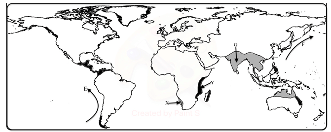
- Use the world map below to answer questions (a) and (b).
-
- Identify the climate marked X and Y. (2 marks)
- Name the ocean currents marked E and F.(2 marks)
- Describe the characteristics of the climate marked G.(8 marks)
- Explain how the following factors influence climate:
- Latitude;(2 marks)
- Aspect; (2 marks)
- Configuration of the coastline. 2 marks)
-
- State three factors that influences atmospheric pressure. (3 marks)
- Describe how relief rainfall is formed.(4 marks)
-
-
- State four factors that determine the amount of surface run-off. (4 marks)
- Describe three ways in which a river transport its load.(6 marks)
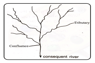
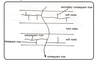
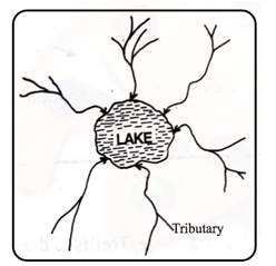
- Using diagrams,describe the following drainage patterns:
- Dendritic; (2 marks)
- Trellis; (2 marks)
- Centripetal. (2 marks)
-
- What is a delta? (2 marks)
- State three ideal conditions under which a delta may be formed.(3 marks)
- State four factors that lead to river deposition. (4 marks)

MARKING SCHEME
-
-
- It causes the occurrence of day and night/apparent movement of the sun from East to West.
- It results in high and low tides/rising and falling of ocean tides/occurrence tides.
- It causes deflection of winds and ocean currents.
- It causes variation of atmospheric pressure over the earth’s surface/pressure difference on earth surface/variation in the
- speed of air masses on earth’s surface.
-
- During sunrise,people living in the east see sunrise earlier than those in the west due to earth’s rotation.
- Movement on the surface of the earth along a straight path while maintaining one direction will bring one back to the
- same starting point from the opposite direction.
- All planets in the solar system are spherical, the earth being one of the planets has a similar shape.
- Satellites photographs of the earth taken from the outer space at great distances from the earth all show that the earth is curved.
- When a ship is approaching land from a distance at sea, smoke is seen first at horizon and then the rest of the ship will appear gradually.
- The earth’s horizon appears circular/curved when observed from a very high point like tower.
- When experimenting with three poles on the same level riveted in the ground on the earth’s surface, the middle pole tends to be on a higher ground than the ones on the sides/taller than the other.If the earth were flat,then the three poles would be of the same height.
-
-
-
- Pressure gradient/difference/barometric gradient.
- Friction force on the earth’s surface.
- Rotation of the earth.
- Temperature of a place.
-
- Land and sea breezes
- Katabatic winds.
- Sirocco/khamsin/berg
- Anabatic winds
- Harmattan
- Fohn winds/Chinook.
-
-
-
- Different minerals have different degree of hardness.
- Some minerals aggregate into distinct shapes.
- Different minerals have different colours.
- Some minerals have different textures.
- Minerals have lustre.
- Different minerals have different specific gravity.
- Different minerals have different tastes/solubility.
- Minerals have different cleavage forms/fracture/tenacity.
-
- Argillaceous
- Arenaceous
- Rudaceous.
-
-
-
- Rossi-Forel scale
- Mercalli scale,
- Richter scale,
- Moment Magnitude Scale(MMS)
-
- Earthquakes trigger off faulting/folding/vulcanicity.
- Earthquakes can cause landslides,which leads to destruction of property and loss of life.
- Where earthquakes occur in the bed of the sea,a tsunami occurs which causes flooding of the adjacent coastal regions.
- When earthquakes occur in settled areas,they cause damage to property and leads to loss of life.
-
-
-
- Most of trees shed their leaves/deciduous.
- Trees leaves are modified to thorns.
- The grass is hardy/tufted.
- Trees are umbrella shaped.
- Trees are scattered.
- Grass dominates the area.
- Trees barely grow to a height of 5 meters.
- Grass grows rapidly to maturity during short rains.
- Trees have deep taproots.
-
- Trees are sources of fuel/charcoal
- Some plants have medicinal value.
- The vegetation provides beauty/aesthetic value.
- Habitat for wild animals.
- Trees provide timber.
- Source of food for human consumption and animals.
-
-
-
- 2 cm on the map represents 1 km on the ground ⇒ 1 cm represents ½ = km⇒ 1 cm represents 500 metres
= 1 cm represents 50,000 cm =1cm/50000cm = 1:50,000 - Nyeri district
Laikipia district.
- 2 cm on the map represents 1 km on the ground ⇒ 1 cm represents ½ = km⇒ 1 cm represents 500 metres
-
- 725565
- 7.4 Km
-
- Bearing = 120º
Direction: SSE - 37º00’E
- Bearing = 120º
-
- Roads tend to be straight in low lying areas e.g.D435
Other roads meander to avoid steep slopes e.g. C75
Roads cross river valleys by means of bridges e.g. B5.
Roads are constructed with some distance from river valleys e.g.road D435 - Relief – There are few settlements to the North western/Githunguri region of the area covered by the map due to steep gradient.
There are dense settlements on the gentle slopes to the South Western region of the area covered by the map.
Transport – There area linear settlements along roads e.g.B5
Vegetation – There are few settlements on the forested area of Aberdare Forestof the area
Drainage – There are few settlements along rivers e.g.river Muringato for fear of flooding.
Urbanization – There are dense settlements in Nyeri towns due to urbanization
- Roads tend to be straight in low lying areas e.g.D435
- It is a trading/commercial centre as indicated by presence of a market/banks.
It is a transport and communication centre as shown by presence of roads/railway line – Kiganjo-Nanyuki railway line.
It is an educational centre as evidence by presence of schools.
It is an administrative centre as shown by presence of a police post/court house/DC office
It is a religious centre as indicated by presence of a church/mosque.
-
-
-
- It is the fracturing or cracking or break up of rocks of the earth’s crust due to tectonic movements causing permanent displacement of rocks of the earth’s crust.
- Normal fault.
Reverse fault.
Thrust fault.
Shear/tear fault.
Anticlinal fault.
- Layers of crustal rocks are subjected to tensional forces.
Lines of weakness develop leading to the formation of a normal fault.
Continued tension forces on the crustal rock results to subsidence of side blocks.
The middle block is left standing upright as a fault block which is known as a block mountain.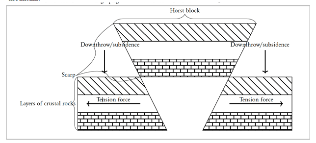
- Vertical faulting across a river valley followed by displacement of rocks leads to the formation of waterfall which can be exploited for the production of Hydro-electric power that can be used in industries.
Features formed through faulting e.g.rift valley/block mountains form tourist attractions sites,which can earn a country foreign exchange.
Mineral deposits found along faults can be exploited for industrial development i.e copper in Uganda and fluorspar in Kenya earning the country foreign exchange when sold.
The rift valley lakes provide water for domestic use/irrigation/industrial use.
Springs can be formed at the base of escarpments,which attract settlements.
Highlands/block Mountains formed block rain bearing winds,resulting in high relief rainfall on windward side which modify the climate of the area making it suitable for agriculture. -
- To find out the factors that led to the formation of the rift valley.
To determine the forces responsible for the formation of the rift valley.
To find out the significance of rift valley in Kenya. - Data analysis
Redrawing sketch maps
Group discussion
Displaying photographs/maps
Writing notes/reports
Presentation of data.
- To find out the factors that led to the formation of the rift valley.
-
-
-
- Hydraulic action
Abrasion
Solution - Headlands and bays
Cliffs,Wave-cut platforms
Caves
Geo
Arch
Stump/stack.
- Hydraulic action
- Wave erosion through abrasion and hydraulic action act on joints or lines of weakness at the base of the cliff.
Wave erosion acts lead to the formation of a notch,which is enlarged to form a cave.
Wave erosion acts on lines of weakness on the cave’s roof.
Weathering through solution acts on the rocks on the surface removing them.
Eventually the surface is connected to the cave forming a vertical shaft called a blowhole.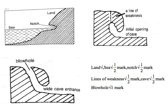
- It forms on a shallow shore where there is change in the angle of the coastline.
Sand and shingle are deposited from the headland seawards by long shore drift.
Continued deposition extends the accumulation of materials seawards.
With time an elongated ridge of sand deposits attached to the mainland called a spit is formed. -
- Raised beaches
Raised wave-cut platforms.
Raised cliffs.
Raised mudflats.
Exposed coral rocks. - Some features such as wave cut platforms attract tourist earning the country foreign exchange.
Exposed coral provide raw materials for cement making.
Coral rock is cut into blocks for use in building and construction.
Coastal emergence features are used for education and research purposes.
- Raised beaches
-
-
-
- X – Tropical Hot Desert Climate
Y – Tropical Marine/maritime. - E – Peruvian Cold Ocean current and F – Kuro Siwo/Kuroshio Warm Ocean current.
- X – Tropical Hot Desert Climate
- G – is Tropical Monsoon climate
Winters are cool and dry.
Summers are hot and wet.
Winds are on-shore in summer/off-shore in winter.
There is low pressure on land in summer/high pressure in winter.
Rainfall is moderate to very high.
Temperature is very high in summer and low in winter.
Humidity is high in summer/low in winter
Relief/convectional rainfall is common.
Skies are cloudy in summer/clear in winter.
Annual range of temperature is large/great.
There is seasonal reversal of winds between land and sea. -
- Areas near the equator are hotter than those far away from the equator,due to higher concentration of the sun’s rays per unit area
- In the Northern hemisphere,outside the tropics,the North-facing slopes are cooler than the South-facing slopes with less direct solar radiation.
- Irregular coastline causes the prevailing wind to be onshore which cause high rainfall on the land.
-
- The rotation of the earth.
The atmospheric temperature.
The altitude of a place. - Warm moist air encounters a mountain/hill/relief barrier.
The air is forced to rise,cooling adiabatically.
On reaching dew point/condensation level,the vapour in the moist air condenses into water droplets which coalesce to form clouds.
When the droplets become too heavy to be held by the clouds in the atmosphere, they fall/drop as relief rain on the windward side.
- The rotation of the earth.
-
-
- High rainfall/high amount/high rainfall intensity/amount of precipitation
The rate of evaporation.
The nature of the slope/gradient of the land.
The nature of the underlying rocks.
The amount of vegetation.
Human activities.
The nature of the soil/the level of saturation. - Solution;It occurs if the rocks in the river bed is soluble.The soluble materials are dissolved in water and carried away in solution form. (1 x 2 = 2 marks)
Suspension;Is the movement of light/fine insoluble materials/silt/mud/clay.The materials float on water and are transported.
Traction;Is the movement of large and heavy materials.The debris is rolled and dragged along the river bed.
Saltation;Is the movement of fairly heavy materials by bouncing along the river bed.The materials leaps and jumps and is momentarily lifted by the water turbulence then dropped out the river bed again. -
- It is shaped like a tree trunk and its tributaries.The tributaries join the main river at acute angles.
- Occurs in areas with alternate hard/soft rocks.The tributaries joins the main river at right angles.
- The rivers flow from all direction and converge at a central basin/lake/swamp.
- It is shaped like a tree trunk and its tributaries.The tributaries join the main river at acute angles.
-
- It is a low-lying accumulation or plain of silt/tract of alluvial deposits deposited by a river at its mouth.
- Large quantities of silt/sediments are carried/deposited at the river mouth.
Low velocity of the river at the mouth/gentle slope at the river mouth.
Weak sea waves/weak tidal currents at the coast/in the sea/at the river mouth.
A shallow continent/shelf/shore/around the river mouth.
High rate of deposition than the rate of removal of silt at the river mouth. - Reduction in river gradient which decreases the velocity of water hence deposition of some load.
Freezing of river water leads to embedment of the load in the ice being deposited.
River entering large water body reduces the speed of the river flow.
Presence of obstacles on the river course which blocks some of its load.
Reduction in river volume which reduces the strength of the river.
Increase in width of the channel makes to spread over wide area.
Increase in the amount of load/size of the load.
- High rainfall/high amount/high rainfall intensity/amount of precipitation
Join our whatsapp group for latest updates
Tap Here to Download for 50/-
Get on WhatsApp for 50/-
Download Geography Paper 1 Questions and Answers - Asumbi Girls Mock Examinations 2022.
Tap Here to Download for 50/-
Get on WhatsApp for 50/-
Why download?
- ✔ To read offline at any time.
- ✔ To Print at your convenience
- ✔ Share Easily with Friends / Students