
INSTRUCTIONS TO CANDIDATES:
- This paper consists of two sections: A and B
- Answer all the questions in section A
- Answer question 6 and any two questions from section B
SECTION A
Answer all questions in this section
-
- Define the term “derelict land”. (1mk)
- State three ways in which mining can pollute the environment. (3mks)
-
- State two causes of food shortage in Kenya. (2mks)
- State three social factors affecting agriculture in Kenya. (3mks)
-
- Name the three main towns that form the cocoa triangle in Ghana. (3mks)
- State three physical conditions favouring cocoa growing in Ghana. (3mks)
-
- Name two varieties of coffee grown in Kenya (2 marks)
- Explain how the following factors favour coffee growing in the central Highlands of Kenya.
- High Altitude (2 marks)
- High Population (2 marks)
-
- State two physical factors influencing beef farming in Argentina. (2mks)
- State two differences between beef farming in Argentina and Kenya. (2mks)
SECTION B
Answer question 6 and any other two questions in this section
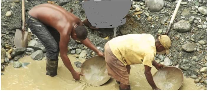
- Study the photograph shown below and use it to answer the following questions.
-
- Identify the type of the photograph shown above. 2mks
- Identify one characteristic of the photograph shown above. 2mks
- Give three parts of a photograph. 3mks
- Name the type of mining method shown above. 2mks
- Explain how the method named above (b) is carried out. 6mks
- Explain three negative effects of the above method of mining on the environment. 6mks
- Draw a sketch diagram to represent the photograph shown above. 4mks
-
-
- Differentiate between land reclamation and land rehabilitation. (2mks)
-
- List three ways in which tsetse fly menace has been controlled in the Lambwe Valley.(3mks)
- Name two areas in Kenya where swamps have been reclaimed. (2mks)
- State four factors which influenced the establishment of Perkerra Irrigation Scheme. (4mks)
- You intend to carry out a field study on Budalangi Flood control.
- Name two methods that have been used to control flooding in Budalangi. (2mks)
- Give three reasons why flood control in Budalangi is important. (3mks)
- List three activities that you would undertake prior to the study. (3mks
- Explain three methods that you would use to present your findings after the study.(6mks
-
-
- Differentiate horticulture from market gardening. (2mks)
- State three features of horticulture. (3mks)
- Explain three differences between horticulture in Kenya and Netherlands. (6mks)
-
- Give three livestock breeds of beef cattle found in Kenya. (3mks)
- Explain three human factors that favour beef production in Argentina. (6mks)
- Give five steps that the government of Kenya has taken to improve beef farming. (5mks)
-
-
-
- Name two types of fishing. (2mks)
- State three factors that influencing fishing. (3mks)
- Explain three reasons why the North East Atlantic fishing ground is extensively and highly developed. (6mks)
-
- What is fish farming? (2mks)
- Describe harpooning as a method of fishing. (4mks)
-
- State two problems facing fishing in Japan. (4mks)
- Explain two similarities between fishing in Kenya and Japan. (4mks)
-
-
-
- Define a forest. (2mks)
- State any four characteristics of Tropical Hardwood forests (4mks)
- Explain how each of the following factors influence the distribution and types of natural forests.
- Soils (2mks)
- Altitude (2mks)
-
- State five importance of forest products in Kenya. (5mks)
- List four measures that have been taken to conserve forests in Kenya. (4mks)
- Compare softwood forests in Kenya and Canada under the following sub-headings
- Tree species (2mks)
- Processing (2mks)
- Marketing (2mks)
-

MARKING SCHEME
-
- This is land which has been left useless after mining has taken place. (1mk)
-
- Air pollution /atmospheric pollution from dust and smoke from tractors and trucks
- Water pollution from spilling of oil from offshore oil drilling.
- Soil pollution from chemicals and explosives used in mining. (3x1=3mks)
-
-
- Erratic weather changes/prolonged drought
- Poor government planning
- High price of farm inputs (2x1=2mks)
-
- Traditions
- Gender-In some communities, food production is a sole responsibility of women and children so the produce and land under cultivation will depend on women and children labour input e.g. W. Africa.
- Traditional foods-Types of crops grown in most parts are traditional/staple foods of those communities.
- Prestige-Maasai value cattle and whoever has the most cattle is regarded in high esteem.
- Land Tenure System
- Cash crops such as coffee can’t be grown on leased land.
- Large scale farming can’t be practiced on excessively fragmented land.
- Nomadic pastoralism and shifting cultivation can be practiced in communally owned land.
- Religious Beliefs
- Hindus don’t practise commercial cattle rearing because they treat cow as a sacred animal.
- Pig rearing isn’t practiced in regions with large presence of Muslims such as Arabic countries because
- Koran terms pig as unclean. Any 3x1=3mks
- Traditions
-
-
-
- Accra
- Kumai
- Takoradi (3x1=3mks)
-
- High temperatures of over 26°c throughout the year.
- High and well distributed rainfall (1300-1500mm annually).
- Low altitude areas below 700m above sea level.
- Slightly drier period during harvesting.
- High relative humidity of over 75%.
- Fertile well drained soils rich in iron and potassium.
- Protection from sunshine which causes high rate of evaporation and winds which cause pods to fall off by inter-planting with shady trees such as bananas, oil palms and kola trees.
-
-
-
-
- Robusta
- Arabica 2 x 1 = 2 marks
-
-
- High Altitude High altitude is associated with high / well distributed rainfall ideal for coffee/The cool temperature in high altitude areas is ideal for coffee farming / less pests infestation in cool areas.
- High population-Provides labour for planting / pruning / harvesting / processing
-
-
- State two physical factors influencing beef farming in Argentina
- Extensive rolling pampas grasslands which provides good natural grazing landscape and allows cattle to graze freely.
- Fertile soils from the slopes of Andes which have given rise to good natural pasture.
- Moderate and well distributed reliable rainfall (about 1000mm annually) received in Pampas which favours growth of good pasture throughout the year and ensures regular water supply for animals.
- Temperatures ranging between 24◦c in summer and about 10◦c in winter which enables grass to grow throughout the year (2x1 = 2 mks)
- State three differences between beef farming in Argentina and Kenya.
Any 2 complete comparison x 1 = 2mksArgentina Kenya Has more beef processing plants Has few processing plants Beef products are exported None of the beef products is exported / most consumed locally Animals have enough pasture Pasture may be scarce in the dry season Animals mainly transported by rail Animals mainly transported by road Exotic breeds mainly reared Both exotic and locally indigenous breeds are reared Corn is used to fatten the beef cattle Animals mainly rely on natural pastures
- State two physical factors influencing beef farming in Argentina
SECTION B
-
-
- Identify the type of the photograph shown above. 2mks
- Ground oblique photograph
- Identify one characteristic of the photograph shown above. 2mks
- Taken from the ground with camera focused on general scenery
- Give three parts of a photograph. 3mks
- Foreground
- Middle ground
- Background
- Identify the type of the photograph shown above. 2mks
- Name the type of mining method shown above. 2mks
- Panning method
- Explain how the method named above (b) is carried out. 6mks
- The method involves digging out the sand/gravel which contains mineral particles
- The particles are mixed with water from the river in a shallow pan.
- The mixture is then whirled.
- The lighter particles of sand/gravel are pushed on the sides of the pan.
- The heavier mineral particles remain at the bottom of the pan.
- The minerals are easily removal by hand as the waited mineral.
- Explain three negative effects of the above method mining on the environment. 6mks
- Makes the land with depression which are dangerous to animals and people.
- Make land infertile for agriculture.
- Breeding ground s for mosquitoes.
- Makes the land susceptible to landslides etc any 3x2=6mks
- Draw a sketch diagram to represent the photograph shown above. 4mks
- The rectangle should be of the same size as the photograph—1mk
- Insert the features in their exact positions-1mk
- Label the important features people and the deposits-1mk
- Give the sketch a suitable title-1mk
-
-
- Land reclamation is the process by which wasteland is converted into farmland for growing crops
and keeping animals while land rehabilitation is the process of restoring land to its former productive state which had been lost due to human and physical factors such as erosion. -
-
- Sterilization of male tsetse flies.
- Clearing of tsetse fly breeding areas.
- Trapping of tsetse flies by use of nets.
- Spraying with insecticides. (any 3x1 = 3mks)
-
- Yala
- Bunyala (2 x 1 = 2mks)
-
- Presence of River Perkerra which provided water for irrigation.
- Gently sloping land allow natural flow of water to the fields of gravity. It also enabled mechanization.
- Soils rich in mineral nutrients enabled variety of crops to be grown.
- Availability of extensive land enabled large-scale cultivation.
- Semi-arid land necessitating irrigation farming.
- Sparse population due to pastoral lifestyle made easy for the scheme to be established.
- Large population of ex-detainees needed to be occupied in a productive way. 4x1=4mks
-
-
-
- Construction of embankments or floodways.
- Building of dykes
- Construction of dams in the streams to hold excess water. (2 x 1 = 2mks)
-
- To control the speed of water.
- To control the volume of water flowing downstream.
- To keep the surrounding areas free from flooding.
- To minimize waterborne diseases.
- To control contamination of wells and other sources of drilling water. (any 3x1 = 3mks)
-
- Locating Budalangi on Atlas maps.
- Reading books of geography on flood control.
- Forming discussion groups before undertaking the study.
- Pre-visit.
- Seeking permission. (any 3x2 = 6mks)
-
- Displaying photographs taken.
- Drawn sketch maps to be displayed.
- Notes taken while in the field is discussed.
- Prosecuting the findings as reports in note form.
- Summary of findings can be put on a table format. (any 3x1 = 3mks)
-
- Land reclamation is the process by which wasteland is converted into farmland for growing crops
-
-
- Horticulture refers to the growing of fruits, flowers and vegetables for commercial purposes while market gardening is the intensive cultivation of vegetables and fruits for sale/in the nearest urban centre.
-
- Farming must be done where there is well developed transport network since produce is highly perishable.
- Crops grown are mainly flowers, fruit and vegetables.
- Produce is market oriented and mainly for export market.
- Farming is mainly labour intensive since the crops require tender care and close monitoring.
- Farms intensively farmed to ensure high yields per unit area.
- Farm scientifically managed e.g seeds selection, constant spraying against pests and diseases replenishment using fertilizers and manure.
- Use of greenhouse/glass houses and irrigation to regulate required moisture high payment to skilled workers. 3x1=3mks
-
- Higher demands of horticulture products locally and internationally from Nethelands than from Kenya.
- Netherlands marketing procedure through cooperatives is well organized than in Kenya.
- Horticultural farming related research is more developed in Netherlands than in Kenya.
- Local and abroad market for Netherland centrally located (European market). Some market for Kenya produce is far leading to increased cost for long distance air transport.
- More advanced and appropriate technology applied in Netherlands than in Kenya.
-
-
- Galloway
- Boran
- Hereford
- Aberdeen Anguis
- Zebu
- Sahiwal
-
- The availability of refrigeration facilities to keep the meat fresh for a long period of time
- Availability of a ready market in the European countries
- The availability of natural grass in parts of the pampas together with highly nutritious planted alfalfa which has increased production of beef cattle
- Better organization and mechanization of the cattle ranches which has resulted to increased production.
- Agriculture has a well developed railway network which helps in transporting beef cattle to the factories (any 3x2=6marks)
-
-
- Providing water by building dams and reservoirs
- Teaching/encouraging farmers to adopt modern methods of rearing and breeding beef cattle
- Funding research in animal disease control and management/education programmes and drug supply
- Providing extension officers to give the farmers the necessary advice
- Decontrolling the price of meat products
- Introducing the pedigree British cattle in some suitable areas/cross breeding them with indigenous breeds
- Ploughing and resowing pasture land with special strains of drought resistant/nourishing gases
-
-
-
-
- Pelagic fishing
- Demersal fishing
- Inshore fishing
- Fresh water fishing (2x1=2mks)
-
- Presence of plankton
- Presence of cold and warm currents
- The nature of the coastline
- Availability of capital
- Level of technology
- Large market
- Reliable transport (3x1=3marks)
-
-
- Numerous sea inlets which provide shelter for the spawning of fish and anchoring of fish boats e.g. fiords of Norway.
- Ruggedness of landscape by glaciated features which is unfavourable for agriculture making fishing another economic activity.
- Warm Atlantic Drift Current which raises the temperature making conditions to be favourable for plankton growth and making fishing possible throughout the year.
- Large continental shelf providing an extensive area for plankton growth.
- Land derived minerals brought by the icebergs from the land which provides plenty of food for plankton which fish eat.
- Dense and affluent population of W. Europe which provides ready market for fish.
- There is a highly developed technology which allows fishing to go on throughout the year (3x2=6mks)
-
- The rearing of fish in ponds (2mks)
-
- It involves the use spears, arrows or sticks to strike the fish in water
- Fish found in clear shallow water is identified
- It is struck using the spears, arrows or stick
- It is then pulled out of the water with the stick/arrow
- Mainly used to catch limited fish/for subsistence use (Any 4x1=4mks)
-
-
- Pollution of water by industrial and oil spillages
- Over fishing resulting to depletion of some species
- Restriction from other territories of waters/limited waters to fish (2x1=2mks)
-
- In both countries fish is used as a raw material in the manufacture of fertilizer, cosmetics and medicine
- In both countries the fish caught is consumed both locally and exported
- In both countries the fish farming projects have been established to supplement the natural fisheries
- In both countries carry out inland and marine fishing activities
- There is over exploitation of fisheries in both countries (2x2=4mks)
-
-
-
-
- It is a continuous and extensive land covered with a closed stand of tall trees. 1x2=2marks
-
- The forests are evergreen as a different species shed their leaves at different times of the year
- The trees are tall with straight smooth trunks
- The trees are form extensive canopies
- The trees have large trunks with protruding giant buttress roots
- The trees take a long time to mature (over 60 years)
-
- Soils
- Deep fertile soils support greater trees growth. Thin soils discourage growth of forest trees
- Different soil mineral nutrients support different types of trees 2x1=2marks
- Altitude
- Altitude affects the temperature such that low temperatures slow the forest growth
- Altitude affect the precipitation/rainfall in an area\
- Soils
-
-
- Trees are sold locally/internationally as timber to earn income i.e source of income
- Trees serve as raw materials in paper/furniture industry
- Forests provide wood which is used as domestic fuel-Fire wood/source of energy in some processing factories e.g tea
- Some tree species found in forests are used as fodder
- Forests provide nuts, fruits and dyes
- Forests trees such as wattle barks are extracted for tanning used in the leather industry
- Some forests are used for medicinal purposes Any 5x1=5marks
-
- Carried out public campaigns on the value of forests
- Replanting trees where they had been cut
- Forest guards and officers employed to protect against destruction of forests
- Carried out research on forestry
- Established forestry training institution at Londiani Research Centre (KEFRI)
Introduced energy saving jikos 4x1=4marks
-
-
- Tree species -In Kenya there are both exotic and indigenous while in Canada they are all indigenous 1x2=2marks
- Processing -Both in Kenya and in Canada the logs are taken to the saw mills where the barks are removed 1x2=2mks
- Marketing -In Kenya most of the wood products are sold locally while in Canada they are sold locally, to USA, Britain and other parts in Europe 1x2=2marks
-
Join our whatsapp group for latest updates
Tap Here to Download for 50/-
Get on WhatsApp for 50/-
Download Geography Paper 2 Questions and Answers - Joint Pre-Mock Exams 2021/2022.
Tap Here to Download for 50/-
Get on WhatsApp for 50/-
Why download?
- ✔ To read offline at any time.
- ✔ To Print at your convenience
- ✔ Share Easily with Friends / Students


