
INSTRUCTIONS
- Answer all questions in section A
- In section B answer question six and any other two questions
SECTION A
-
- Differentiate between relative humidity and absolute humidity (2mks)
- State three significance of water vapour in the atmosphere (3mks)
-
- What do you understand by the term vertical Earth movement. (2mks)
- Identify three causes of earth movements (3mks)
-
- Give two process of slow mass movement. (3mks)
- State two physical conditions that may influence landslides (2mks)
-
- State two factors that may determine the amount of surface run-off (2mks)
- Use the diagram below to answer questions (i) and (ii)
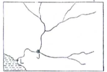
- The drainage pattern is
- Name part labelled J and L (2mks)
-
- Define the term oceans (2mks)
- State three reasons why ocean water are salty (3mks)
SECTION B
Answer question 6 and two other questions in this section
- Use the map of Oyugis (1:50,000) sheet 130/1 provided, to answer the questions that
follow-
- Give two adjoining index to the south and East of oyugis map (2mks)
- Convert the scale of the map extract given 1:50000 into a statement scale
- What is the bearing, distance and direction of the trigonometrical station Ingrid square 7030 from brickworks in grid square 7832 (3mks)
- Enlarge by two area bounded by easting 85 and 88,northing 39 and 41 (2mks)
On it label and name the following- River Awach kasipul (1mk)
- Forest boundary (1mk)
- woodland
- Explain three factors that have favoured trade in the map extract. (6mks)
-
- Citing evidence from the map state two social services offered in the area covered by Oyugis map (2mks)
- Describe the relief of the area covered by the map (5mks)
-
-
- What is rotation of the Earth (2mks)
- The diagram below represents one effect resulting from rotation of the Earth.
Use it to answer part (b( i) and (b( ii) below;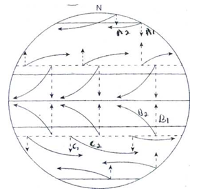
- Name the effect of rotation represented by the diagram (1mk) (ii)
- Citing specific pressure zones and winds shown, describe the process represented in;
- A1 and A2 (3mks)
- B1 and B2 (3mks)
- C1 and C2 (3mks)
- Explain how the following factors affects temperature
- Altitude (3mks)
- Latitude (4mks)
- Explain three reasons why a weather station must be sited away from tall building and trees (6mks)
-
-
- Name two types of vegetation. (2mks)
- Give two physiographic factors influencing vegetation distribution (2mks)
- The diagram below shows vegetation zones of an East African mountain. Use it to answer questions below(bi) and b(ii)
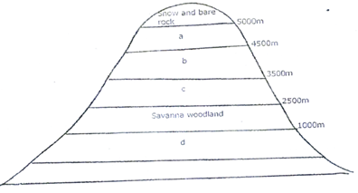
- Name the zones a,b,c and d (4mks)
- Give one reason why there is no vegetation cover on the top of the mountain (1mk)
-
- State the names given to temperate grassland vegetation in:
- North America
- Argentina
- Explain three uses of savannah vegetation (6mks)
- State the names given to temperate grassland vegetation in:
- Explain four characteristics of tropical desert vegetation (8mks)
-
-
- With the aid of well labelled diagram describe how a crag and tail is formed (6mks)
- Name and describe four types of glacial moraines (8mks)
-
- Identify two features formed by glacial erosion in the highlands (2mks)
- State three factors which encourage glacial deposition (3mks)
- Explain three positive effects of glaciations to human activities (6mks)
-
- state
- Three factors which contribute to the development of deserts (3mks)
- Three processes through which winds erodes a desert land scape (3mks)
- Using well labelled diagrams explain how a rock pedestal is formed (6mks)
- Explain three significance of wind depositional features (6mks)
- Suppose you carry out a field sturdy on the action of water in a desert
- List four features you are likely to study (4mks
- State three problems you are likely to experience during the field study (3mks)
- state
MARKING SCHEME
SECTION A
-
- Differentiate between relative humidity and absolute humidity(2mks)
- Relative humidity refers to the ratio of absolute humidity of a given mass of air to the maximum amount of moisture this mass of air can hold at the same temperature while absolute humidity refers to the actual amount of moisture in a given mass of air at a particular temperature (2mks)
- State three significance of water vapour in the atmosphere(3mks)
- Water vapour in the atmosphere stores energy in the atmosphere for development of storms.
- Amount of water vapour in the atmosphere determine the type and amount of precipitation to be received in a particular area.
- Green house effect of water vapour in the atmosphere regulates air temperature – absorbs terrestrial radiation regulating heat loss (3mks)
- Differentiate between relative humidity and absolute humidity(2mks)
-
- What do you understand by the term vertical Earth movement. (2mks)
- These are movement within the rocks of the crust that operates along the radius of the earth; from inside to the surface or from the surface to the interior of the earth
- Identify three causes of earth movements (3mks)
- Isostatic adjustments in the crust
- Movement of magma through the crust
- Convectional current in the mantle
- Gravitational force (3mks)
- What do you understand by the term vertical Earth movement. (2mks)
-
- Give two process of slow mass movement. (2mks)
- Soil creep
- Talus creep/scree creep
- Solifluction
- Rock creep
- State two physical conditions that may influence land slides (2mks)
- Steep slopes which allow soils to move down easily
- Presence of loose soil/absence of firm rock which means that soils are easily destabilize.
- Occurrence of earthquakes which interferes with the stability of soils.
- Heavy rain facilitates movement of materials down slope (2mks)
- Give two process of slow mass movement. (2mks)
-
- State two factors that may determine the amount of surface run-off (2mks)
- High intensity of rainfall
- Low rate of evaporation increase surface run-off
- Slope of land/steep slopes encourage surface run-off
- Presence of vegetation/bare surface increase’s surface run-off
- Saturated soil surface (2mks)
- Use the diagram below to answer questions (i) and (ii)
- The drainage pattern is
- dendritic (1mk)
- Name part labelled J and L (2mks)
- J-confluence
- L-river mouth
- The drainage pattern is
- State two factors that may determine the amount of surface run-off (2mks)
-
- Define the term oceans (2mks)
- Large and extensive body of saline (Salty) water occupying a basin between continent between continent
- State three reasons why ocean water are salty (3mks)
- Volcanic materials (Vulcanicity) add salt to ocean water
- Mineral salts were present during formation of oceans
- Sea water dissolves salt directly from rocks on the sea floor
- Rivers carry dissolved salt from land and deposit in oceans
- Define the term oceans (2mks)
SECTION B
Answer question 6 and two other questions in this section
- Use the map of Oyugis (1:50,000) sheet 130/1 provided, to answer the questions that follow
-
- Give two adjoining index to the south and East of Oyugis map (2mks)
- South-awendo
- East -kisii
- Convert the scale of the map extract given 1:50000 into a statement scale (2mks)
- 1cm represents 0.5km
- Give two adjoining index to the south and East of Oyugis map (2mks)
- What is the bearing, distance and direction of the trigonometrical station Ingrid square 7030 from brickworks in grid square 7832 (3mks)
- Bearing-25
- Distance 8.5km
- Direction south west
- Enlarge by two area bounded by easting 85 and 88,northing 39 and 41 (2mks)
On it label and name the following- River Awach kasipul (1mk)
- Forest boundary (1mk
- woodland (1mk)
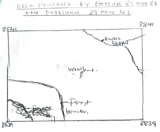
title (1mk)
rectangle correct dimensions (1mk)
- Explain three factors that have favoured trade in the map extract. (6mks)
- Dense population –provide market
- Roads –make it easy to transport good/raw materials
- Market/ shops/trading centre –provide places to sell goods
-
- Citing evidence from the map state two social services offered in the area covered by Oyugis map (2mks)
- Education –evidenced by schools
- Health services-hospital/health centre
- Administration-chiefs office
- Security-police post
- Religious-churches
- Describe the relief of the area covered by the map (5mks)
- There are many hills e.g God
- There are river valley e.g along the course of river AWACH
- There are steep slopes on the eastern parts o f the map
- The relief is dissected due to presence of many rivers
- The highest point is around soth east aproximately5900feet
- The western part is gentle /undulating
- Citing evidence from the map state two social services offered in the area covered by Oyugis map (2mks)
-
-
- What is rotation of the Earth (2mks)
- Is the spinning of the earth on its axis
- The diagram below represents one effect resulting from rotation of the Earth. Use it to answer part (b)( i) and (b)( ii) below;
- Name the effect of rotation represented by the diagram (1mk)
- deflection of winds and ocean currents
- Citing specific pressure zones and winds shown, describe the process represented in;
- A1 and A2 (3mks)
- A1-North winds from polar high approach temperate low pressure zone
- A2 Curiolis/rotation of the earth delectsthe winds making winds to approach as polar easterlies
- B1 and B2
- B1- south winds from subtropical high pressure zone approach I.T.C.Z
- B2 – south winds deflected and approach the equatorial trough as south east trade winds.
- C1 and C2 (3mks)
- C1-South winds from subtropical zone approach temperate low pressure zone
- C2- Rotation deflects winds to approach as temperate low as westerllies
- A1 and A2 (3mks)
- Name the effect of rotation represented by the diagram (1mk)
- Explain how the following factors affects temperature
- Altitude (3mks)
- At high altitude air is rare/have few particles therefore most heat from surface is lost to space
- Low altitude have more particles which block terrestrial radiation from being lost to space leading to high temperature
- Atmosphere is heated from below thus lower atmosphere higher temperature
- Low atmosphere experience high pressure leading to high temperature
- Latitude (4mks)
- At the equator sun rays strikes the surface at right angle leading to higher concentration of rays/low temperature
- At high latitude sunrays strike the surface at acute angle/less concentration of rays/low temperature
- At the poles there is a large distance with the surface thus low temperature
- At the equator surface exposed is small due to curve leading to high temperatures
- Polar region surface area large because its flattened/low temperature
- Altitude (3mks)
- Explain three reasons why a weather station must be sited away from tall building and trees (6mks)
- To avoid interruption of speed and direction of wind approaching the weather station
- So that shadow from tall building /trees does not interfere with temperature in the station
- So that to have clear observation of the sky/clouds while at the station
- So that rains from the sky can fall directly into ground rain gauge for accuracy
- What is rotation of the Earth (2mks)
-
-
- Name two types of vegetation . (2mks)
- Natural vegetation
- Derived vegetation
- Cultivated vegetation
- Give two physiographic factors influencing vegetation distribution (2mks)
- Altitude
- Aspect
- Terrain and drainage( 2x1=2mks)
- Name two types of vegetation . (2mks)
- the diagram below shows vegetation zones of an East African mountain. Use it to answer questions below(bi) and b(ii)
- Name the zones a,b,c and d (4mks)
- A-Heath and moorland vegetation
- B-Bamboo forest
- C-Rain forest
- D-Savannah grasslands ( 4x1=4mks)
- Give one reason why there is no vegetation cover on the top of the mountain (1mk)
- Too cold for plants to survive
- Covered by snow (1x1)=1
- Name the zones a,b,c and d (4mks)
-
- State the names given to temperate grassland vegetation in:
- North America ........Prairies (1mk)
- Argentina……….Pampas
- Explain three uses of savannah vegetation (6mks)
- Grazing-plenty tall and short grasses are used for grazing domestic animals/wild animals
- Reduces soil erosion-savanna vegetation acts as soil cover hence reduces soilerosion
- Habitat for bees and wild animals-trees in savannah are habitat for bees which provide honey and home for wild animalse.g gazelles
- Medicinal use-some shrubs and herbs in savannah are used as medicine e.g
- Fuel-trees provide wood for fuel
- Humus in the soil-decomposing long grass form fertile soil suitable for wheat/maize growing (3x2=6mks)
- State the names given to temperate grassland vegetation in:
- Explain four characteristics of tropical desert vegetation (8mks)
- Some plants have long roots to enable them tap water far deep in the ground
- Some plants have shallow root system which enables them to take moisture from the top layers of soil
- Some plants have sunken stomata and waxy leaves to reduce rate of transpiration
- Some plants have succulent stems to allow them store water
- Some plants are short lived i.e complete their cycle within the short wet period
- Some plants e.g tubers and corms remain dormant during dry spell until wet period stimulates them to germinate
-
-
- With the aid of well labelled diagram describe how a crag and tail is formed(6mks)
- A resistant igneous rock lie on the path of moving glacier
- Moving ice slightly erodes the resistant rock on the upstream then goes over and around the rock
- The material carried by the ice and those erode on the upstream of the resistant rock are deposited on the down streamside of the resistant rock
- The deposits together with the protected rocks on the down streamforms an elongated tail
- Steep resistant rock forms the crag while elongated leeward side is the tail
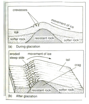 labelled diagrams 2mks,
text (4mks)
- Name and describe four types of glacial moraines (8mks)
- Lateral moraines-glacial materials carried at the sides of the glacier
- Terminal moraine-deposited along the edge of ice sheet;appears as ridge like;forms when ice is stagnant for long
- Recessional /stadial moraines-series of nearly parallel terminal moraines;indicates where snow line of the ice was static
- Medial moraine-material carried on the surface but in the middle of the glacier
- Ground moraine-material carried at the base of the glacier
- Englacial moraine- materials carried within the glacier
-
- Identify two features formed by glacial erosion in the highlands (2mks)
- Cirque
- Arete
- Pyramidal peak
- Glacial trough
- Fiords
- State three factors which encourage glacial deposition (3mks)
- Large amount of glacial drift/load forcing glacier to drop some
- Large weght of glacier above causes extreme pressure at the base leading to melting of ice hence deposition of materials
- Climatic changes like summer causes melting of ice hence deposition of materials
- Friction between moving ice and surface force materials held thus deposition
- Gentle slope in the lowland allow accumulation of materials which are later deposited by ice
- Explain three positive effects of glaciations to human activities (6mks)
- Features formed like Aretes are tourist attraction and earn foreign exchange
- Submerged glacial troughs are good site for construction of ports/ habour
- Till plains forms fertile soils for agriculture
- Morraine damned lakes are used for fishing/water for domestic purposes
- Hanging valleys forms waterfall for hydro-electric power generation
- Glacial toughs in the highlands forms good grazing areas for animals during summers
- Identify two features formed by glacial erosion in the highlands (2mks)
- With the aid of well labelled diagram describe how a crag and tail is formed(6mks)
-
- State
- Three factors which contribute to the development of deserts (3mks)
- Increased temperature and excessive evaporation
- Prolonged droughts/low rainfall
- Scanty vegetation, dry and scanty human activities
- Existence of cold ocean current on the path of rain bearing winds
- Rain shadow effects of high mountains leading to low rains in leeward side
- Continentally/remoteness fropm the sea
- Human activities such as deforestration/over stocking
- Anticycones/descending winds /diverging wind
- Three processes through which winds erodes a desert land scape (3mks)
- Deflation
- Abrasion
- Attrition
- Three factors which contribute to the development of deserts (3mks)
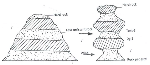
- Using well labelled diagrams explain how a rock pedestal is formed (6mks)
- Rock outcrop with alternating hard and less resistant rock lie horizontally in the path of moving winds
- Rock outcrop is attacked by wind abrasion
- The less resistant layers are eroded faster than the hard layers
- There is more abrasion at the base of the rock outcrop due to larger particles carried near the surface
- An irregular feature with narrow base called ROCK PEDESTAL is left standing out
- Explain three significance of wind depositional features (6mks)
- Dunes and barchans attract tourist to earn foreighn exchange
- Loess deposited in wetter areas provide fertile soils for agriculture
- Dunes can be used as hide out for desert creatures/are warm during cold nights
- Barchans may cover areas that may be good for pastrolism
- Some sand deposits may contain minerals alluvials that may be of economic value
( labelled diagrams 2mks,text 4mks)
- Suppose you carry out a field sturdy on the action of water in desert
- List four features you are likely to study (4mks)
- Pediments
- Playas/Salinas/salas/sebkha
- Mesas
- Buttes
- Wadis/dry valley/lagh
- Bajada/bahada
- Alluvial fans
- State three problems you are likely to experience during the field study (3mks)
- High temperatures
- Dust storms
- Poor communication/transport
- Scarcity of water /food
- Insecurity/dangerous snakes/bandits
- Lonelinss in deserts
- Scarcity of resource persons
- List four features you are likely to study (4mks)
- State
Join our whatsapp group for latest updates
Tap Here to Download for 50/-
Get on WhatsApp for 50/-
Download Geography Paper 1 Questions and Answers - Momaliche Joint Pre Mock Exams 2022.
Tap Here to Download for 50/-
Get on WhatsApp for 50/-
Why download?
- ✔ To read offline at any time.
- ✔ To Print at your convenience
- ✔ Share Easily with Friends / Students


