
INSTRUCTION TO CANDIDATES
- Answer all the questions in Section A. In section B answer question six and any other two questions from this section.
- All answers must be written in the answer booklet provided.

Questions
SECTION A
Answer all the questions in this section.
-
- Name two theories of the origin of the earth. (2marks)
- State three effects of the rotation of the earth on its own axis. (3 marks)
-
- State two ways in which underground water may reach the earth’s surface (2marks).
- Draw a well labelled diagram of the hydrological (5marks)
- Give three reasons why the recording of data at a school weather may be inaccurate (3marks)
-
- What is natural vegetation? (2marks)
- State three characteristics of the Mediterranean type of vegetation (3marks)
-
- Name two major earthquake zones of the world (2marks)
- Give three factors that influence the rate of weathering (3marks)
SECTION B
Answer question 6 and any other two questions from this section
- Study the map of Nyeri 1:50,000 (sheet 120/4) provided and answer the following questions.
-
- What is the longitudinal extent of the map extract? (2marks)
- Give the Four figure grid reference of the labour camp near Mweiga estate (2marks)
- Identify two districts in the area covered by the map. (2marks)
-
- Give two methods used to represent relief on the map (2marks)
- State three problems that maybe encountered during the construction of roads in the area covered by the map (3marks)
- Citing evidence from the map, give three reasons why cattle rearing is widespread in Nyeri area. (6marks)
-
- Apart from administration, give three other services provided in the area covered by Nyeri map
- Describe the distribution of settlement in the area covered by the map (4marks).
- Give two factors that favour coffee growing in Nyeri Map (2marks)
-
-
-
- Apart from fold mountains, name three other features resulting from folding (3marks)
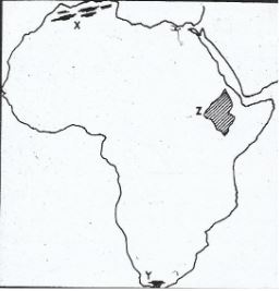
- On the outline map of Africa provided, name the feature marked x, y and z. (3marks)
- Describe the formation of Fold Mountains (5marks)
-
- Name four major orogeny (4marks)
- Using a well labelled diagram describe the formation of an Asymmetrical fold (6marks)
- Explain two ways in which Fold Mountains influence climate (4marks)
-
-
-
- What is a river divide (2marks)
- Describe three ways by which a river transports its load. (6marks)
- Describe the characteristics of river in its old stage (4marks)
- Describe each of the following drainage patterns
- Superimposed drainage pattern (3marks)
- Centripetal drainage pattern (2marks)
-
- What is a delta (2marks)
- The diagram below shows a section of a river. Use it to answer the questions that follow. Name the features marked S and T (2marks)
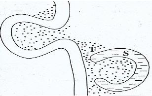
- State four conditions that are necessary for the formation of the feature marked S. (4marks)
-
-
- Describe the following characteristics of minerals
- Colour (2 marks)
- Cleavage (2marks)
- Hardness (2 marks)
-
- Give two types of igneous rocks (2marks)
- Explain three conditions necessary for the growth of coral polyps (3marks)
- Describe three ways in sedimentary rocks are formed (9marks)
-
- What is rock metamorphism? (2marks)
- State three causes of heat and pressure during metamorphism. (3marks)
- Describe the following characteristics of minerals
-
-
- What is soil catena (2marks)
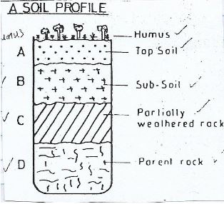
- Draw a labelled diagram to show a well develop soil profile. (5marks)
- State three characteristics of soils found in the arid regions of Kenya (3marks)
- Give three factors that determine the colour of soils (3mks)
- Describe how lateralization occurs (6marks)
- Describe how the following types of erosion occur.
- Sheet erosion (2marks)
- Gulley erosion (2marks)
- Give two factors that influence the thickness of a soil (2marks)
-
Marking Scheme
-
- Name two theories of the origin of the earth.
- Passing Star Theory / Big bang
- Nebular Cloud Theory
- State three effects of the rotation of the earth on its own axis. (3 marks)
- It causes the occurrence of day and night.
- It causes deflection of winds and ocean currents.
- It causes the rising and falling of the tides.
- It causes variation in time at different longitudes.
- It causes difference in atmospheric pressure on the surface of the earth.
- Name two theories of the origin of the earth.
-
- State two ways in which underground water may reach the earth’s surface (2marks).
- Through springs / capillary
- Through wells
- Through transpiration.
- Draw a well labelled diagram of the hydrological (5marks)
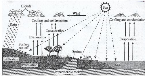
- State two ways in which underground water may reach the earth’s surface (2marks).
- Give three reasons why the recording of data at a school weather may be inaccurate (3marks).
- Use of defective instruments
- Human error
- Interference with the instruments
- Poor study of a weather station
- Extreme weather conditions
- Natural calamities
Any 3 x 1 (3marks)
-
- What is natural vegetation (2marks)
- It is the plant cover that grows naturally / wildly on the earth’s surface without interference by man or his animals.
- State three characteristics of the Mediterranean type of vegetation (3marks)
- Some plants have small / thick – skinned / leathery leaves
- Some plants have long tap roots
- Some plants have thick barks
- Some plants have large fleshy bulbous roots
- Some plants have a shiny waxy leaves
- Some trees are deciduous
- Some plants are evergreen
(Accept any other correct point)
- What is natural vegetation (2marks)
-
- Name two major earthquake zones of the world (2marks)
- Circum – Pacific belt
- The Tethyan / Mediterrenean belt
- The Great Rift valley belt
- Mid Atlantic ocean belt
- Give three factors that influence the rate of weathering (3marks)
- Rain / Temperature
- Nature of the rock
- Angle of slope
- Living organisms / flora and fauna
- Human activities
- Name two major earthquake zones of the world (2marks)
- Study the map of Nyeri 1:50,000 (sheet 120/4) provided and answer the following questions.
-
- What is the longitudinal extent of the map extract? (2marks)
- 36045’ - 37000’E
- Give the four figure grid reference of the labour camp near Mweiga estate. (1mark)
- 6661
- Identify two districts in the area covered by the map. (2marks)
- Nyeri district
- Laikipia district
- What is the longitudinal extent of the map extract? (2marks)
-
- Give two methods use to represent relief on the map (2marks)
- Contours
- Trigonometrical station
- Depression symbols
- State three problems that maybe encountered during the construction of roads in the area covered by the map (3marks)
- Steep slopes which may necessitate road cutting / many road bends / meanders.
- Many river / river valleys s may lead to the construction of many bridges / culverts
- The high density of settlements may lead to high cost of compensation.
- Give two methods use to represent relief on the map (2marks)
- Citing evidence from the map, give three reasons why cattle rearing is widespread in Nyeri area. (6marks)
- Presence of scrub and scattered trees shows that there is natural pasture for cattle.
- Presence of many rivers / sources of water show that there is adequate water for cattle.
- The area has high attitude / 1000m which provides cool conditions suitable for cattle rearing
- Dense market / settlement to premarket for cattle / cattle product
-
- Apart from administration, give three other services provided in the area covered by Nyeri map (3marks).
- Medical services / health services
- Educational Services
- Religious service
- Commercial services / Trading
- Transportation services
- Security
- Tourism services
- Describe the distribution of settlement in the area covered by the map. (4marks)
- There is linear settlement along transport lines and edges of forest.
- Present of clustered settlement in urban centres.
- There is sparsely settlement on Northern part.
- South East areas has dense settlement on Northern part.
- There are no settlement in forested areas / national parks.
- Give two factors that favour coffee growing in Nyeri map. (2marks)
- Presence of high rainfall evidenced by permanent rivers and forests.
- High attitude, necessary for coffee growing - 1700M
- Dense settlement in coffee growing area evidenced by labour lines, clustered settlement in southern area.
- Several feeder roads connecting to all weather road of evidenced by road numbered D434, E576.
- Apart from administration, give three other services provided in the area covered by Nyeri map (3marks).
-
-
-
- Apart from fold mountains, name three other features resulting from folding (3marks)
- Synclinal valleys / Depressions
- Rolling plains
- Ridges
- Intermontane basins / Intermontane plateaus.
- On the outline map of Africa provided, name the feature marked x, y and z. (3 marks)
- X – Atlas mountains
- Y – Cape ranges
- Z – Ethiopian highlands
- Apart from fold mountains, name three other features resulting from folding (3marks)
- Describe the formation of Fold Mountains (5marks)
- Geosyncline are formed on the earth’s surface
- Prolonged and extensive erosion occurs on the surrounding higher grounds.
- Sedimentary are deposited in the geosyncline forming thick layers.
- The weight of the sediments cause subsidence of the geosyncline triggers off compressional forces which draw the higher grounds closer.
- The sediments wrinkles at the edges to form Fold Mountains.
-
- Name four major orogeny (4marks)
- Charnian orogeny
- Caledonian orogeny
- Hercynian / Armenian orogeny
- Alpine orogeny
- Using a well labelled diagram describe the formation of an Asymmetrical fold (6marks)
- Crustal rock layers are subjected to unequal compressional forces.
- The compressional force is stronger on one side than the other.
- This forms a fold with one limb steeper than the other.
- The limbs are not symmetrical from the axis and thus called asymmetrical fold.
- Name four major orogeny (4marks)
- Explain two ways in which Fold Mountains influence climate (4marks)
- Temperature of land slopes that face the sun are warmer than those facing away from the sun (aspect)
- Wind slopes of Fold Mountains receive higher rainfall while leeward slopes have lower rainfall due to the rain shadow effect.
- Higher attitudes of Fold Mountains experience low temperature that cause the formation of snow and ice on the slopes.
- Fold Mountains may cause temperature inversions as cold dense mountains winds slow down to the valley bottoms at night and push up the warm air in the valleys.
- High attitudes of Fold Mountains lead to lowering of pressure and temperature upwards.
-
-
-
- What is a river divide (2marks)
- It is a ridge / high ground that separates two or more river basins.
- Describe three ways by which a river transports its load. (6marks)
- Traction / Rolling / Sliding
- The large and heavy particles of the river load are rolled / dragged along the river bed.
- Saltation / hoping /hydraulic lift; particles that are not too heavy but cannot remain suspended in water are momentarily lifted by the water turbulence and at times dropped onto the river bed.
- Solution – Soluble minerals are dissolved in the river water and carried away in solution.Suspension / floating in water, Any 3 x 2 (6marks)
- What is a river divide (2marks)
- Describe the characteristics of river in its old stage (4marks)
- The speed of flow is low
- Gradient of the plain is low
- River forms pronounced meanders
- There is formation of river terraces / bluff / cliffs
- Presence of small islands / braided channels / river braids.
- Describe each of the following drainage patterns
- Superimposed drainage pattern (3marks)
- The drainage system develops on a rock structure that overlay a totally different one.
- The river valley cuts through the surface rock layers on the underlying rocks.
- Gradually the surface rocks are removed and the underlying rocks now become exposed on the river bed.
- The river maintains its original directions of flow despite the new rock structure.
- The superimposed drainage bears no relationship to the existing rock structure / it is discordant with the rock structure.
- Centripetal drainage pattern (2marks)
- The pattern develops in an area with a central basin. Rivers drain into the depression from different directions.
- Superimposed drainage pattern (3marks)
-
- What is a delta (2marks)
- It is a low – lying plain platform of alluvial deposits of silt or mild at the month of a river.
- The diagram below shows a section of a river. Use it to answer the questions that follow.
Name the features marked S and T (2marks)- S – Ox bow lake
- T – Alluvial deposits
- State four conditions that are necessary for the formation of the feature marked S (4marks)
- Presence of pronounced meanders in the flood plain
- Heavy load being carried by the river.
- A reduction in the river gradient / reduction in the river energy to erode vertically / low velocity.
- Lateral erosion on the outer side of the river banks
- Deposition on the inner side of the river banks
- Periodic flooding
- What is a delta (2marks)
-
-
- Describe the following characteristics of minerals
- Colour (2 marks)
- Different minerals display different colours e.g. minerals that have iron have dark colours.
- Cleavage (2marks)
- Minerals have patterns in which they break, some minerals break into thin layers while others break along layers.
- Hardness (2 marks)
- This is the measure of resistance of a mineral to disintegrate. Some minerals such as diamond have a high resistance while others such as talc are soft.
- Colour (2 marks)
-
- Give two types of igneous rocks (2marks)
- Intrusive rocks / plutonic / hypatyssal rocks
- Extrusive rocks / volcanic rocks
- Explain three conditions necessary for the growth of coral polyps (3marks)
- They require warm water / 200 – 300c in order to live
- They require well oxygenated water for them to grow fast
- They require water that is free from sediments because silt interferes with their ability to gather food.
- They require enough light in the water for the growth of plankton which is the food for polyps.
- They require saline water from which the polyps extract lime to construct their skeletons.
- Give two types of igneous rocks (2marks)
- Describe three ways in sedimentary rocks are formed (9marks)
- Mechanically formed sedimentary rocks:- Rock fragment are transported by wind / water / ice. They are deposited in layers, over a long period of time they are compacted into a hard rock.
- Organically formed sedimentary rocks:– Remains of plants. Animals are deposited in layers, over a long period time, the remains are compacted forming a hard rock.
- Chemically formed sedimentary rocks:– Dissolved minerals are transported into water bodies. They are then transported into water bodies, they are then precipitated / evaporated over a long period of time, the precipitates / evaporates are then compacted to form a hard rock.
Way – 1 mark
Description – 2marks
-
- What is rock metamorphism? (2marks)
- A process where pre-existing rocks undergo physical and chemical changes to form new rocks due to heat or pressure.
- State THREE causes of heat and pressure during rock metamorphism. (3marks)
- Compressional forces earth movements.
- Heat from hot magma.
- Weight from the overlying rock layers.
- What is rock metamorphism? (2marks)
- Describe the following characteristics of minerals
-
-
- What is soil catena (2marks)
- Soil catena is the sequence of different soils on a slope.
- Draw a labelled diagram to show a well develop soil profile.
- State three characteristics of soils found in the arid regions of Kenya (3marks)
- The soils are light in colour
- Some are saline
- Some are sandy / stoney
- Some are in loose texture
- Some are thin
- Some have low moisture content.
- What is soil catena (2marks)
- Give three factors that determine the colour of soils (3marks)
- The type of parent rock
- The amount of organic matter / humus
- Chemical composition / degree of concentration of iron oxides
- Amount of water in the soil / the drainage of the soil
- Describe how lateralization occurs (6marks)
- During the wet season, mineral salts in the top layer of the soil dissolves in rain water.
- The dissolved minerals percolate / seep downwards from the top soil to the sub soil.
- The dissolved minerals are deposited further downwards to the lower layer.
- Insoluble minerals such as iron and aluminium accumulate on top layers to form a crust of laterite.
- During the dry season some of the soluble minerals are moved from the bottom layers to the top of the soil by capillary action.
- Describe how the following types of erosion occur.
- Sheet erosion (2marks)
- This occurs on gentle slopes which are bare when heavy rain falls, water spreads over a large area. As water moves, it removes the top layer of soil evenly over the area.
- Gulley erosion (2marks)
- It occurs on steep slopes.
- Rain water cuts deep groves / channels / rills on the slopes. The channels are widened and deepened to form gullies.
- Sheet erosion (2marks)
- Give two factors that influence the thickness of a soil (2marks)
- Nature of the bedrock
- Rate of weathering of parent rock which is determined by its mineral composition.
- Length of time taken for the soil to develop
- Vegetation cover
-
Join our whatsapp group for latest updates
Tap Here to Download for 50/-
Get on WhatsApp for 50/-
Download Geography Paper 1 Questions and Answers - Bunamfan Cluster Pre Mock Exam 2022.
Tap Here to Download for 50/-
Get on WhatsApp for 50/-
Why download?
- ✔ To read offline at any time.
- ✔ To Print at your convenience
- ✔ Share Easily with Friends / Students


