
INSTRUCTIONS TO STUDENTS
- This paper has two sections A and B
- Answer ALL the questions in section A. In section B answer questions 6 and any other TWO questions.

QUESTIONS
SECTION A
Answer all the questions in this section.
-
- State three reasons why it is important to study Geography. (3 marks)
- What is the relationship between Geography and Agriculture? (2 marks)
-
- What is weather forecasting? (2 marks)
- List three elements of weather. (3 marks)
- Study the diagram below and use it to answer questions (a) and (b) below:
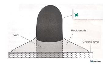
- Identify the feature marked X. (1 mark)
- Describe how the feature is formed. (4 marks)
-
- What is karst landscape? (2 marks)
- State three factors that influence the occurrence of underground water. (3 marks)
- The diagram below shows lowland glaciated features. Study the diagram and answer questions (a) and (b).
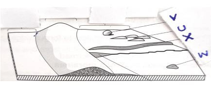
- What is an outwash plain? (2 marks)
- Name the features marked U, V and W. (3 marks)
SECTION B
Answer question 6 and any other TWO questions from this section.
- Study the map of Nyeri 1:50000 (sheet 120/4) provided and answer the following questions
-
- Name the two districts in the northern part of the map extract. (2 marks)
- Give the latitudinal extent of they are covered by the map. (2 marks)
- According to the marginal information provided in the map, what is the magnetic variation of the area when the map was drawn. (2 marks)
- Calculate the area of Nyeri forest on the map. Give your answer in square kilometres. (2marks)
- Describe drainage of the area covered by the map. (5 marks)
- Citing evidence from the map, explain three factors that favours the growing of coffee in Nyeri area. (6 marks)
- Explain three factors that have influenced settlement in the area covered by the map. (6marks)
-
-
-
- Differentiate between rocks and minerals. (2 marks)
- Describe the following characteristics of minerals.
- Color. (2 marks)
- Hardness. (2 marks)
-
- What are igneous rocks? (2 marks)
- State three differences between plutonic and volcanic rocks. (3 marks)
- Describe the formation of the following rocks.
- Mechanically formed sedimentary rocks. (3 marks)
- Chemically formed sedimentary rocks. (3 marks)
-
- Identify the missing type of rocks. (3 marks)
Original rock
Metamorphic rock
Limestone
(i)
(ii)
Graphite
Granite
(iii)
- Suppose you were to carry out a field study on rocks at the Kenyan coast. State two reasons as to why you would ask for permission from the school administration. (2marks)
- What reasons would you give for the widespread of sedimentary rocks at the coastal plain? (3marks)
- Identify the missing type of rocks. (3 marks)
-
-
-
- Name three types of river erosion (3 marks)
- Describe the following river erosional presses.
- Abrasion (4 marks)
- Solution (3 marks)
-
- What is river rejuvenation (2 marks)
- Identify three features that result from river rejuvenation. (3 marks)
-
- Name two types of submerged highland coasts. (2 marks)
- State two factors influencing deposition by ocean waters. (2 marks)
- Explain three significance of oceans to human activities. (6 marks)
-
-
-
- Differentiate between soil texture and soil structure. (2 marks)
- Apart from living organisms, name four other components of soil. (4 marks)
- The diagram below shows different layers of soil. Use it to answer questions (b) (i), (ii) and (ii)
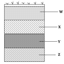
- Name the soil layers X ,Y and Z (3 marks)
- Give two main processes of soil formation which takes place in horizon W. (2 marks)
- State four characteristics of soil in horizon X. (2 marks)
- Explain how the following farming practices may result to loss of soil fertility
- Continuous irrigation. (2 marks)
- Over grazing. (2 marks)
- Over cultivation. (2 marks)
- Explain ways in which natural vegetation may prevent soil from erosion. (4 marks)
-
MARKING SCHEME
SECTION A
Answer all the questions in this section.
-
- State three reasons why it is important to study Geography. (3 marks)
- It leads to development of career opportunities
- Promotes positive attitudes towards protection
- Encourages international awareness
- Encourages time management or responsibility
- Helps to develop mental skills
- What is the relationship between Geography and Agriculture? (2 marks)
- Geography studies the relief of an area which helps identify areas suitable for agricultural countries.
- Geography studies different types of soils. Which influences types of agriculture crops.
- Geography deals with the study of climate and weather which is important in the planning of agricultural activities such as planting and harvesting.
- State three reasons why it is important to study Geography. (3 marks)
-
- What is weather forecasting? (2 marks)
- It is the production of the state or condition of the atmosphere of a given place within a specified time.
- List three elements of weather. (3 marks)
- Humidity
- Air pressure
- Rainfall
- Wind
- Cloud cover
- What is weather forecasting? (2 marks)
- Study the diagram below and use it to answer questions (a) and (b) below:
- Identify the feature marked X. (1 mark)
- Plug dome/plug volcano/spine volcano
- Describe how the feature is formed. (4 marks)
- Earth movements from a vent in the earths crustal rocks.
- Highly viscous magma is forced out through the vent as cylindrical mass.
- The eruption is explosive breaking the rocks around the vent and the rock debris settle around the vent.
- The magma cools solidified rapidly as if reses form a plug.
- More underground the pushes upwards rising higher above the ground to form a cylindrical circular pillar of solid lava called plug
- Identify the feature marked X. (1 mark)
-
- What is karst landscape? (2 marks)
- It is a landscape made of chalk, limestone or dolomite rock surface and underground features form due to carbonation and solution processes.
- State three factors that influence the occurrence of underground water. (3 marks)
- The amount of rainfall
- Slope gradient
- Vegetation cover
- Level of ground saturation
- The rate of evaporation
- What is karst landscape? (2 marks)
- The diagram below shows lowland glaciated features. Study the diagram and answer questions (a) and (b).
- What is an outwash plain? (2 marks)
- It is gentle slopping made of unconsolidated materials of clay, soil, and gravel deposited in a surface manner in lowland glaciated area by meet water.
- Name the features marked U, V and W. (3 marks)
- U – Drum line
- V – Eratic block
- W – Moraine dammed lake.
Answer question 6 and any other TWO questions from this section.
- What is an outwash plain? (2 marks)
- Study the map of Nyeri 1:50000 (sheet 120/4) provided and answer the following questions
-
- Name the two districts in the northern part of the map extract. (2 marks)
- Laikipia district
- Nyeri district
- Give the latitudinal extent of they are covered by the map. (2 marks)
- From 0 º19 ʹ South to 0 º30 ʹ South
- According to the marginal information provided in the map, what is the magnetic variation of the area when the map was drawn. (2 marks)
- Magnetic variation =1 º 31 ʹ
- Calculate the area of Nyeri forest on the map. Give your answer in square kilometres. (2marks)
Complete square = 2
Incomplete squares= 21
Area = 2 +21/2 =2 + 10.5
= 12.5 km
- Name the two districts in the northern part of the map extract. (2 marks)
- Describe drainage of the area covered by the map. (5 marks)
- The main drainage features is rivers
- River Chanya is the main river
- Most rivers are permanent
- There are many reservoirs in the area covered by the map
- River Chanya and its tributaries form a dendritic drainage pattern
- Rivers generally flow from west to east/westwards
- There is a high density of /many rivers in the area covered by the map
- Most rivers originate from Aberdares forest
- Most rivers are bending/winding
- Most rivers are in the youthful stage
- Citing evidence from the map, explain three factors that favours the growing of coffee in Nyeri area. (6 marks)
- The area experiences cool temperatures that favours coffee growing due to high altitude as evidenced by contours that rise above 1600 metres above the sea level
- The area receives high rainfall that is adequate for growing coffee as evidenced by the presence of many permanent rivers/presence of forests
- The area has well drained soils suitable for coffee growing evidenced by the presence of gently sloping terrain as indicated by moderately spaced contours
- The area has adequate supply of labour necessary for coffee picking evidenced by the high density of settlement
- The area has well developed transport network for transporting coffee to the coffee factories evidenced by the many roads/tracks
(NB the factor ,evidence and explanation must be given)
- Explain three factors that have influenced settlement in the area covered by the map. (6marks)
- Transportation; the area is served by many roads which makes movement of people and goods easy thus encouraging settlement along the roads
- Drainage; there are few settlement/no settlement along the rivers/near reservoirs this may be due to seasonal flooding/presence of pests and water borne diseases
- Vegetation; there are no settlement /few settlements within the forests due to land being reserved for forests
- Relief; there are many settlements in the south eastern part because the land is gently sloping/most of the river valleys have no settlement
-
-
-
- Differentiate between rocks and minerals. (2 marks)
A rock is a substance that is an aggregate of mineral particles forming the earths crust while minerals are naturally occurring inorganic substances with definite physical and chemical properties occurring at or beneath the surface of the earth. - Describe the following characteristics of minerals.
- Color. (2 marks)
- Different minerals display different colors e.g gold is yellow in color .
- Hardness. (2 marks)
- This is a measure of resistance of a mineral to disintegration. Some minerals e.g. diamond have a high resistance to breakage while others are soft .e.g. Talc
- Color. (2 marks)
- Differentiate between rocks and minerals. (2 marks)
-
- What are igneous rocks? (2 marks)
- These are rocks that are formed from cooling and solidification of magma or lava on or below the earth’s surface.
- State three differences between plutonic and volcanic rocks. (3 marks)
- Plutonic rocks form from magma while volcanic rocks form from lava.
- Plutonic rocks form deep in the earth’s crust while volcanic rocks form on the surface of the earth.
- During formation of plutonic rocks magma cool slowly while during formation of volcanic rocks, lava cools rapidly
- Plutonic rocks form large crystals /coarse grained /textured while volcanic rocks form small crystals or no crystals at all/are fine grained. (3×1=3mks)
- What are igneous rocks? (2 marks)
- Describe the formation of the following rocks.
- Mechanically formed sedimentary rocks. (3 marks)
- Sediments of rock particles are derived from pre-existing rocks by the process of weathering.
- The sediments are transported by agent of erosion e.g., water, wind, ice and deposited in sea, or on land in layers.
- The sediments undergo compaction and cementation as more layers are deposited and consolidated to form a new rock.
- Chemically formed sedimentary rocks. (3 marks)
- They form when minerals in rocks gets dissolved and carried in solution in water bodies.
- Water reaction with these dissolved minerals leads to precipitation of the sediments.
- The sediments accumulate at the bottom of the water body and finally compress to form a rock.
- Mechanically formed sedimentary rocks. (3 marks)
-
- Identify the missing type of rocks. (3 marks)
Original rock
Metamorphic rock
Limestone
i) Marble
ii) Coal
Graphite
Granite
iii) Gneiss
- Suppose you were to carry out a field study on rocks at the Kenyan coast. State two reasons as to why you would ask for permission from the school administration. (2marks)
- For the administration to be informed of some students being out of school for official purpose.
- To help in preparation of the budget needed.
- To help in preparation of the transport means. (any first 2 ×1=2mks)
- What reasons would you give for the widespread of sedimentary rocks at the coastal plain? (3marks)
- The coastal plains were once part of the extensive continental shelf of the Indian ocean and so sedimentation took place.
- Shallow continental shelf provided conducive environment for coral polyps to form sedimentary rocks.
- Many rivers deposit their load to at the mouth in the ocean accumulating to form sedimentary rocks.
- Identify the missing type of rocks. (3 marks)
-
-
-
- Name three types of river erosion (3 marks)
- Describe the following river erosional presses.
- Abrasion (4 marks)
- Solution (3 marks)
- Name three types of river erosion (3 marks)
-
- What is river rejuvenation (2 marks)
- Identify three features that result from river rejuvenation. (3 marks)
-
- Name two types of submerged highland coasts. (2 marks)
- State two factors influencing deposition by ocean waters. (2 marks)
- Explain three significance of oceans to human activities. (6 marks)
-
-
-
- Differentiate between soil texture and soil structure. (2 marks)
Soil texture is the size distribution of minerals particles composed in the soil while soil texture is the way the individual soil particles are arranged and joined to form lumps/clusters OR Soil texture is the coarseness and fineness of soil grains while soil structure is the arrangement of soil particles to form particular shape - Apart from living organisms, name four other components of soil. (4 marks)
- Organic matter
- Soil water /moisture
- Soil air
- Mineral particles/weathered materials/inorganic matter
- Differentiate between soil texture and soil structure. (2 marks)
- The diagram below shows different layers of soil. Use it to answer questions (b) (i), (ii) and (ii)
- Name the soil layers X ,Y and Z (3 marks)
- X – Sub soil
- Y – Weathered parent rocks materials
- Z – Parent rock
- Give two main processes of soil formation which takes place in horizon W. (2 marks)
- Elluviation
- Leaching
- State four characteristics of soil in horizon X. (2 marks)
- Consists mainly of silicate clays, alluminiun and iron
- Made up of hard pan/laterite
- Soils are prismatic/columnar
- It’s a zone of illuviation/zone of enrichment
- Soils are generally dark in colour
- Name the soil layers X ,Y and Z (3 marks)
- Explain how the following farming practices may result to loss of soil fertility
- Continuous irrigation. (2 marks)
- Causes leaching of soil nutrients making the soil deficient of soluble minerals causing soil salinity
- Over grazing. (2 marks)
- Leads to the removal of vegetation cover thus exposing the soils to agents of soil erosion which will remove the top fertile soils
- Over cultivation. (2 marks)
- Weakens the soil structure making it easy for agents of soil erosion carrying away the top soil
- May increase oxidation resulting to loss of organic matter
- Continuous irrigation. (2 marks)
- Explain ways in which natural vegetation may prevent soil from erosion. (4 marks)
- Plant leaves cover and reduce the force of the rain drops controlling splash erosion
- Vegetation cover increases the rate of rain water infiltration into the soil reducing surface run off controlling sheet erosion
- The roots of plants increase the rate of rain water percolating into the soil controlling erosion
- The plant roots bind the soil particles together thus controlling erosion
- Plant cover reduces the rate of soil water evaporation making the soil moist/wet and compact
- Dead and decaying vegetation matter adds humus to the soil making the soil particles bound
-
Join our whatsapp group for latest updates
Tap Here to Download for 50/-
Get on WhatsApp for 50/-
Download Geography Paper 1 Questions and Answers - Kassu Jet Pre Mocks 2022.
Tap Here to Download for 50/-
Get on WhatsApp for 50/-
Why download?
- ✔ To read offline at any time.
- ✔ To Print at your convenience
- ✔ Share Easily with Friends / Students


