
GEOGRAPHY
FORM 1 OPENER EXAM
TERM 3 2022
INSTRUCTIONS
- Answer all the questions in this paper
- Name the branches of Geography (3marks)
- Explain the relationship between Geography and the following disciplines
- Mathematics (2marks)
- History (2marks)
- Define the following terms.
- Galaxy (2marks)
- Milky Way (2marks)
-
- Name two planets without satellites. (2marks)
- Explain the origin of the earth according to the nebula cloud theory (4marks)
- State the reasons why the earth has life on it. (3marks)
- Explain three forces that contribute to the shape of the earth. (6marks)
- Calculate the following.
- What is the longitude of station x when it is 08:00am while in Nairobi at longitude 37°E the time is 12.00 noon? (2marks)
- What is the time at point Y 30°W when the time at point Z is 20°E is 4:00pm? (2marks)
-
- What is the International Date Line? (2marks)
- State the effects of international date line? (2marks)
- List the five main latitudes on the globe. (5marks)
- The diagram below represents the structure of the earth. Use the diagram to answer questions that follows.
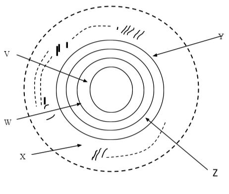
- Label all parts of the above diagram. (5marks)
- V
- W
- X
- Y
- Z
- List the composition of the crust. (2marks)
- Name the other layer of discontinuity that make up the interior of the earth. (1mark)
- Label all parts of the above diagram. (5marks)
-
- Define weather (2marks)
- Identify five elements of weather (5marks)
- What considerations should be put into account while siting a weather station? (4marks)
- Give five characteristics of the Stevenson’s screen (5marks)
- What are the elements of the weather measured from a Stevenson’s screen? (2marks)
-
- Describe the way a rain gauge works. (4marks)
- Why is it possible that the data recorded in a school weather station will not be accurate? (3marks)
- Identify the ways in which clouds are classified. (3marks)
-
- Using a well labeled diagram, describe the occurrence of relief rainfall (6marks)
- Outline the characteristics of Inter-tropical convergence zone (ITCZ). (4marks)
-
- Students from one of the schools in Kirinyaga county, carried out a field study in Kerugoya Market. What five preparations did they make apart from making a work schedule? (5marks)
- Why will it be necessary to make a work schedule before the study? (3marks)
- State three disadvantages of using interviewing method in the field study. (3marks)
- Study the statistical data below and answer the questions that follow
Month J F M A M J J A S O N D Rainfall in mm 39 40 67 163 240 72 64 68 79 103 96 67 - Calculate the mean of the rainfall amounts. (2marks)
- The annual range of rainfall (2marks)
MARKING SCHEME
- Name the branches of Geography (3marks)
- Physical Geography
- Human Geography
- Practical Geography
- Explain the relationship between Geography and the following disciplines
- Mathematics (2marks)
- Geography uses mathematical tools and techniques to analyze and present geographical data such as graphs and piecharts. In map work mathematical skills are used in calculating distance and area.
- Geography uses mathematical tools and techniques to analyze and present geographical data such as graphs and piecharts. In map work mathematical skills are used in calculating distance and area.
- History (2marks)
- This is the study of past events and their specific dates of occurrence while geography explains why and where such occurrences rook place. History uses geographical maps, charts and graphs to show migration of people.
- This is the study of past events and their specific dates of occurrence while geography explains why and where such occurrences rook place. History uses geographical maps, charts and graphs to show migration of people.
- Mathematics (2marks)
- Define the following terms.
- Galaxy (2marks)
- It’s a group of stars within the universe.
- It’s a group of stars within the universe.
- Milky Way (2marks)
- Galaxy or nebula to which the earth belongs.
- Galaxy (2marks)
-
- Name two planets without satellites. (2marks)
- Mercury and Venus
- Mercury and Venus
- Explain the origin of the earth according to the nebula cloud theory (4marks)
- States that the solar system formed from a cloud or nebula of gases
- As the nebula rotates it flattened into a disc having high concentration of materials at the center
- The flattening was due to the centrifugal force of the earth.
- Materials at the outer section condensed while those at the center remained gaseous
- Temperatures were higher at the center of the nebula leading to the accumulation of the materials that formed planets
- Continued accumulations led to formation of more planets. The earth is one of them.
- Name two planets without satellites. (2marks)
- State the reasons why the earth has life on it. (3marks)
- Presence of air/oxygen
- Presence of water
- Presence of force of gravity
- Explain three forces that contribute to the shape of the earth. (6marks)
- force of gravity- It attracts objects on the earth surface and materials within the earth towards the centre of the earth thus making the earth to appear round.
- Centripetal force- it pulls the north pole and south pole towards each other hence flattening the area at the poles.
- Centrifugal force- It creates the bulging at the equator.
- Calculate the following.
- What is the longitude of station x when it is 08:00am while in Nairobi at longitude 37°E the time is 12.00 noon? (2marks)
- Time difference = 12:00 - 8:00 = 4hrs
4 x 15 = 60°
Longitude = 60° - 37° = 23°W
- Time difference = 12:00 - 8:00 = 4hrs
- What is the time at point Y 30°W when the time at point Z is 20°E is 4:00pm? (2marks)
- Difference between longitudes is 50°
1° - 4 min To the west you lose on time
50° - ? Therefore 4:00 pm – 3hrs 20min
= 50 x 4 = 200 = 12:40pm
200/60 = 3hrs 20min
- Difference between longitudes is 50°
- What is the longitude of station x when it is 08:00am while in Nairobi at longitude 37°E the time is 12.00 noon? (2marks)
-
- What is the International Date Line? (2marks)
- It is the meridian lying at 180° either East/west
- It is the meridian lying at 180° either East/west
- State the effects of international date line? (2marks)
- On crossing this longitude while going to the west, a day is lost while a day is gained while crossing to the east
- On crossing this longitude while going to the west, a day is lost while a day is gained while crossing to the east
- What is the International Date Line? (2marks)
- List the five main latitudes on the globe. (5marks)
- Equator
- Tropical of Cancer
- Tropical of Capricorn
- Arctic Circle
- Antarctic Circle
- The diagram below represents the structure of the earth. Use the diagram to answer questions that follows.
- Label all parts of the above diagram. (5marks)
- V - Outer core / barysphere
- W - Gutenburg Discontinuity
- X - Hydrosphere
- Y - Oceanic crust / sima
- Z - Upper mantle
- List the composition of the crust. (2marks)
- Continental crust – sial
- Oceanic crust - Sima
- Name the other layer of discontinuity that make up the interior of the earth. (1mark)
- Mohorovicic Discontinuity/moho
- Label all parts of the above diagram. (5marks)
-
- Define weather (2marks)
- It is the condition of the atmosphere of a place for a short period of time /
- It is the condition of the atmosphere of a place for a short period of time /
- Identify five elements of weather (5marks)
- Temperature
- Precipitation
- Sunshine
- Wind
- Pressure
- Humidity
- Cloud cover
- What considerations should be put into account while siting a weather station? (4marks)
- Should be built on gently sloping ground to avoid flooding.
- Should be built on an open ground with a wide view of the sorroundings.
- Should be located away from tall structures like trees and buildings which may interfere with the measurements
- Should be located in an open area where there is free flow of air.
- Give five characteristics of the Stevenson’s screen (5marks)
- It has metallic legs to avoid destruction by ants.
- It has louvers to allow free air flow
- It is painted white for it to reflect the heat
- It has double roof to prevent heat from reaching inside
- It is raised 1.2 meters high to allow free air flow
- What are the elements of the weather measured from a Stevenson’s screen? (2marks)
- Temperature (both minimum and maximum).
- Humidity of the atmosphere
- Define weather (2marks)
-
- Describe the way a rain gauge works. (4marks)
- A rain gauge is made up of a metallic tin inside which there is a funnel to direct the water, and a collection jar. When it rains, water enters the collection jar using the funnel. When rain ceases the collection jar is removed and water poured into a measuring can where it is measured in millimeters and recorded.
- A rain gauge is made up of a metallic tin inside which there is a funnel to direct the water, and a collection jar. When it rains, water enters the collection jar using the funnel. When rain ceases the collection jar is removed and water poured into a measuring can where it is measured in millimeters and recorded.
- Why is it possible that the data recorded in a school weather station will not be accurate? (3marks)
- The instruments could be faulty.
- There could be irregular reading and recording of data
- The students could be lacking the necessary skills
- There could be interference with the instruments by the students
- Describe the way a rain gauge works. (4marks)
- Identify the ways in which clouds are classified. (3marks)
- According to heights
- According to their colour
- According to their shape
-
- Using a well labeled diagram, describe the occurrence of relief rainfall (6marks)
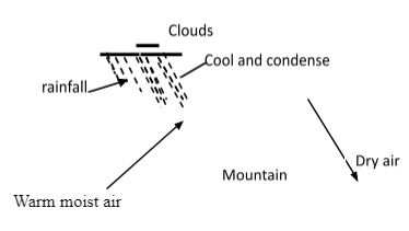
- Warm moist air moves from a water body
- It rises along a mountain side
- It cools, condenses and form clouds
- Outline the characteristics of Inter-tropical convergence zone (ITCZ). (4marks)
- It migrates to the north and south of the equator due to the apparent movement of the sun
- It forms between latitude 23½°N and 23½°S
- It’s a zone of low pressure.
- It is a convergence point of the North East and the South East trade winds.
- It is a zone of high convectional rainfall usually accompanied by thunder and lightning
- It is a region of high temperature.
- It migrates to the north and south of the equator due to the apparent movement of the sun
- Using a well labeled diagram, describe the occurrence of relief rainfall (6marks)
-
- Students from one of the schools in Kirinyaga county, carried out a field study in Kerugoya Market. What five preparations did they make apart from making a work schedule? (5marks)
- Seeking permission from the school and other relevant authorities.
- Preparing data collection methods
- Preparing the questionnaires
- Gathering required tools for the study.
- Preparing the route maps
- Reading from secondary sources
- Carrying out a reconnaissance
- Discussing the topic in class
- Why will it be necessary to make a work schedule before the study? (3marks)
- So as to ensure proper time management and check time wastage.
- To ensure all important areas are adequately covered.
- It helps one to remain on course during the study
- It will guide on time allocation for all activities
- One is able to measure the progess of the study even as it is being carried out.
- Students from one of the schools in Kirinyaga county, carried out a field study in Kerugoya Market. What five preparations did they make apart from making a work schedule? (5marks)
- State three disadvantages of using interviewing method in the field study. (3marks)
- It is time consuming where there is direct discussions as respondents are not suppose to be hurried
- Expensive to conduct if there is traveling.
- There could be language barrier and translations may alter the questions and responses
- Group interviews limit openness among the respondents hence important information is withheld
- Study the statistical data below and answer the questions that follow
Month J F M A M J J A S O N D Rainfall in mm 39 40 67 163 240 72 64 68 79 103 96 67 - Calculate the mean of the rainfall amounts. (2marks)
- 39+40+67+163+240+72+64+68+79+103+96+67 = 1098
1098 = 91.5 mm
12
Mean is 91.5mm
- 39+40+67+163+240+72+64+68+79+103+96+67 = 1098
- The annual range of rainfall (2marks)
- 240 - 39 = 201
The range is 201mm
- 240 - 39 = 201
- Calculate the mean of the rainfall amounts. (2marks)
Join our whatsapp group for latest updates
Tap Here to Download for 50/-
Get on WhatsApp for 50/-
Download Geography Questions and Answers - Form 1 Opener Exam Term 3 2022.
Tap Here to Download for 50/-
Get on WhatsApp for 50/-
Why download?
- ✔ To read offline at any time.
- ✔ To Print at your convenience
- ✔ Share Easily with Friends / Students


