
GEOGRAPHY
FORM 2 OPENER EXAM
TERM 2 2021
INSTRUCTIONS
- Answer all the questions
-
- Define Geography (1mk)
- Draw a well labeled diagram to show the centrality of geography (4mks)
-
- Give two reasons for the shape of the Earth (2mks)
- State three characteristics of sedimentary rocks (3mks)
-
- What is the longitude of city Y whose local time is 8.00am, when the local time at green which meridian 0° is 12.00 noon? (2mks)
- Give three characteristics of the Inner core of the earth (3mks)
-
-
- Differentiate between faulting and folding. (2mks)
- Draw a well labeled diagram to show the parts of a normal fault. (5mks)
-
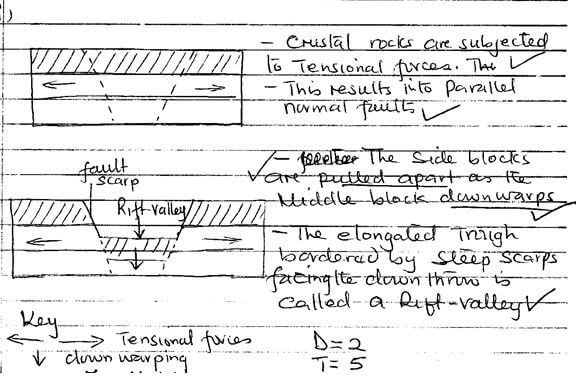
- Describes the formation of Rift Valley by tensional forces by use of well labeled diagram. (7 marks)
- Explain three significance of vulcanicity to Human activities. (6mks)
-
-
-
- differentiate between weather and climate. (2mks
- Explain four factors that influence climate. (8mks)
- Explain two effects of climate change on the physical environment. (4mks)
-
- Study the map of Kitale provided below and answer the questions that follow:-
-
- Convert the linear scale on the map into a representative fraction (show your working) (3mks)
- Name the districts covered in the map (3mks)
- Calculate the area covered by Kitale township (2mks)
-
- What is ITCZ? (2mks)
- State four characteristics of the Equatorial climate (4mks)
- You are to carry out a field study in the Rift Valley
- Outline your preparation (4mks)
- What three other fault features would you study besides the rift valley. (3mks)
- State one hypothesis of your study (1mk)
- Give three follow up activities you would carry out (3mks)
-
-
-
- Differentiate between direction and bearing. (2mks)
- State two traditional methods used to show direction on maps. (2mks)
-
- Explain four uses of maps. (4mks)
- State three marginal information a good map must have. (3mks)
- List three ways used to locate places on a map. (3mks)
-
-
-
- Define photograph. (2mks)
- State 3 types of ground photographs. (3mks
-
- List three types of graphs used for statistical presentation. (3mks)
- Explain two advantages of comparative line graph. (2mks)
- Explain two disadvantages of a comparative bar graph. (2mks)
-
MARKING SCHEME
-
- Define Geography (1mk)
- this is the scientific study of the distribution and interrelationship of natural and human phenomena on the earth surface in relation to man.
- Draw a well labeled diagram to show the centrality of geography (4mks)
1 mark for every well drawn and labeled part
- Define Geography (1mk)
-
- Give two reasons for the shape of the Earth (2mks)
- The centrifugal forces causes the bulging at the equator 2x1=(2mks)
- the centripetal forces causes the flattening at the poles
- The gravitational pull causes the rounding effects on the earth.
- State three characteristics of sedimentary rocks (3mks)
- They consist of different sediments
- They are stratified 3 x 1 =3mks
- they are flexible/elastic/bend easily
- May contain fossils
- Give two reasons for the shape of the Earth (2mks)
-
-
- What is the longitude of city Y whose local time is 8.00am, when the local time at green which meridian 0° is 12.00 noon? (2mks)
12.00-8.00=4hrs
1hr=15o
4x15=60oW √ 1mrk
- What is the longitude of city Y whose local time is 8.00am, when the local time at green which meridian 0° is 12.00 noon? (2mks)
- Give three characteristics of the Inner core of the earth (3mks)
- Has a radius of 1370Km
- It is solid in nature
- Has a temperature between 4500-6000oC
- Has a density of 17.0gm/cc 3 x 1= 3mrks
-
-
-
- Differentiate between faulting and folding. (2mks)
- Faulting is the fractional/breaking of crustal rocks due to the tectonic forces while folding is the bending/crumbling of crustal rocks due to compression forces
- Draw a well labeled diagram to show the parts of a normal fault. (5mks)
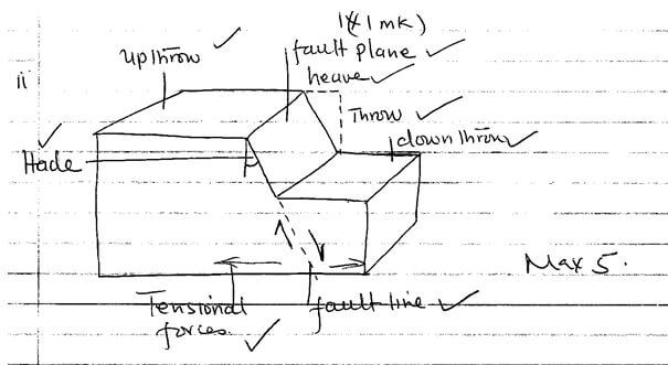
- Differentiate between faulting and folding. (2mks)
-
- Describes the formation of Rift Valley by tensional forces by use of well labeled diagram. (7 marks)
- Explain three significance of vulcanicity to Human activities. (6mks)
- It has contributed greatly to the scenic beauty of landscape
- Formation of rich metallic minerals
- Geothermal steam and power 2 x 3= 6mrks
- production of carbon dioxide
- volcanic rocks are valuable as building stones and road materials
- Volcanic mountains are catchment areas, sources of rivers and springs and are thickly forested
- Describes the formation of Rift Valley by tensional forces by use of well labeled diagram. (7 marks)
-
-
-
- differentiate between weather and climate. (2mks)
- Weather is the daily atmospheric conditions of a place over a short period of time while climate
- Is the average weather condition of a given place over along time usually 30-35 years.
- Explain four factors that influence climate. (8mks)
- Latitude: it influence temperature on the surface of the earth.Areas that are nearer the equator experience higher temperatures than those further away. It also influences the seasonal variation of rainfall.
- Altitude: it influence temperature and atmospheric pressure of the area. Low altitude areas are warmer than higher altitude areas.
- Distance from the sea: the temperature of places that are near the sea and where the prevailing winds are onshore, tend to be modified.
- Aspect: In the northern hemisphere ,the south facing slopes are warmer than the slopes facing north. This is because the slopes facing north never receive direct sunshine while the slopes facing south do.
- Winds and Air masses: if the wind is blowing from a warm region, it warms the region it is blowing over. On the other hand if the wind is cool it cools the area causing low temperatures in the region it is blowing over.
- Ocean currents: coastal region that are washed by ocean currents experience a modification of their climate particularly when the prevailing winds are onshore.
- Explain two effects of climate change on the physical environment. (4mks)
- Flooding from rising sea levels: As the ocean expand sea level rise causing flooding of low lying areas especially along the coastal region.
- Wetter and warmer conditions may increase pest and deseases which will affect humans ,crops and livestock.
- In temperate regions winters are likely to be wetter and summers drier
- There will also be widespread of changes in natural ecosystems with grassland and desert areas expanding and forested areas shrinking and moving polewards. Probrems such as desertification and soil erosion are likely to increase
- differentiate between weather and climate. (2mks)
-
- Study the map of Kitale provided below and answer the questions that follow:-
-
- Convert the linear scale on the map into a representative fraction (show your working) (3mks)
- 2cm rep 1km
1km = 100,000cm
1rep 50,000cm
2CM/2 rep 100000/2 =1/50,000
- 2cm rep 1km
- Name the districts covered in the map (3mks)
- west- pokot
- Trans-Nzoia
- elgeyo- marakwet
- Calculate the area covered by Kitale township (2mks
- 12.5km2 + 0.5(12+13km2)
- Convert the linear scale on the map into a representative fraction (show your working) (3mks)
-
- What is ITCZ? (2mks)
- ITCZ is the inter tropical convergence zone, a low pressure belt that shifts between the tropics due to the overhead sun, in which the trade winds converge.
- State four characteristics of the Equatorial climate (4mks)
- High temperatures (average of 26o/24-27o)
- Small annual range of temperature of 3-4oC 4 x1
- High annual rainfall (1500mm-2500mm)
- double maxima of rainfall
- High humidity through out the year
- Thick cloud covers through out the year
- Low atmospheric pressure
- Mainly conventional rainfall accompanied by thunder storm
- Rainfall is throughout the year
- What is ITCZ? (2mks)
- You are to carry out a field study in the Rift Valley
- Outline your preparation (4mks)
- Seek permission from relevant authorities
- carry out a reconnaissance
- formulate hypothesis and objectives
- carry out a library research/content analysis
- divide into groups and assign responsibilities
- collect field study equipments
- prepare a work schedule
- decide on the methodology of data collection and recording
- What three other fault features would you study besides the rift valley. (3mks)
- Fault scarp
- Block/horst mountain
- Tilt block
- State one hypothesis of your study (1mk)
- Any appropriate hypothesis e.g There are many block mountains within the rift valley.
- Give three follow up activities you would carry out (3mks)
- process the photographs
- write a report
- holding group discussion 3x1
- draw and display charts
- Outline your preparation (4mks)
-
-
-
- Differentiate between direction and bearing. (2mks)
- Direction is a distance from a particular point on the map or on the surface of the earth while Bearing is indicated as direction measured as an angle and given in degrees
- State two traditional methods used to show direction on maps. (2mks)
- Use of landmarks
- use of heavenly bodies
- Differentiate between direction and bearing. (2mks)
-
- Explain four uses of maps. (4mks)
- to show direction and location of places
- human and economic activities e.g. settlements patterns, land use, communication network
- to indicate physical features e.g. relief , drainage pattern etc.
- weather trends; rainfall distribution
- political and administrative boundaries
- use by military
- State three marginal information a good map must have. (3mks)
- Map series
- Titles
- Grid system
- Key-scale
- Edition, publisher and copyright
- Explain four uses of maps. (4mks)
- List three ways used to locate places on a map. (3mks)
- By use of direction, bearing and distances 3x1`
- By use of place names
- By use of latitudes and longitudes
- By use of grid reference system.
-
-
-
- Define photograph. (2mks)
- It is an image of an object, scene in form of a print or slide recorded by a camera on a film and later transferred onto a specially prepared paper.
- State 3 types of ground photographs. (3mks)
- Ground close up
- Ground ob lique
- Ground general view
- Define photograph. (2mks)
-
- List three types of graphs used for statistical presentation. (3mks)
- Simple line graph
- Simple bar graph
- Combined line and bar graph
- Compound / cumulative bar graph
- Explain two advantages of comparative line graph. (2mks)
- Different variables can be compared easily 2x1
- The graph is easy to read and interpret
- It gives a clear visual impression
- Explain two disadvantages of a comparative bar graph. (2mks)
- it is difficult to follow the trend of any particular variable throughout the period
- Total contribution of the values of a group cannot be given at a glance
- List three types of graphs used for statistical presentation. (3mks)
-
Join our whatsapp group for latest updates
Tap Here to Download for 50/-
Get on WhatsApp for 50/-
Download Geography Questions and Answers - Form 2 Term 2 Opener Exams 2021.
Tap Here to Download for 50/-
Get on WhatsApp for 50/-
Why download?
- ✔ To read offline at any time.
- ✔ To Print at your convenience
- ✔ Share Easily with Friends / Students


