
QUESTIONS
Instructions:
Answer all the questions in the spaces provided
-
- Give two layers of discontinuity found in the internal layers of the earth. (2mks)
- State three characteristics of the mantle. (3mks)
-
- Name two forms of precipitation. (2mks)
- Study the diagram below and answer the questions that follow.
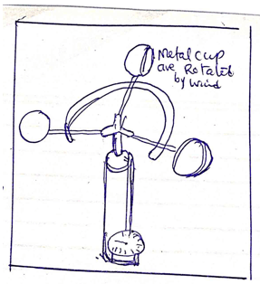
- Identify the diagram above. (1mk)
- Describe how the instrument is used in the weather station. (4mks)
-
- Define the term mineral. (2mks)
- Explain three forms of metamorphism. (6mks)
-
- Name three causes of earth movement. (3mks)
- Give three features formed as a result of horizontal earth movements. (3mks)
-
- Study the diagram below and answer the questions that follow.
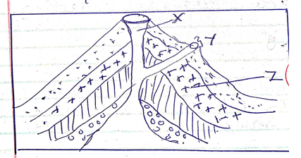
- Identify the features represented by the above diagrams. (1mk)
- Name parts marked X, Y, Z. (3mks)
- Describe how the feature named above is formed. (3mks)
- You are to carry out field study on volcanicity on Mt. Longonot in Kenya.
- Give three methods of collecting data. (3mks)
- State the follow-up activities for the field. (3mks)
- Study the diagram below and answer the questions that follow.
-
- Explain constructive consequences of vulcanicity to human activities. (6mks)
- Give three human activities that causes earthquakes. (3mks)
-
- State two modern methods of showing direction on maps. (2mks)
- State four ways of locating places on a map. (4mks)
- Name three methods of representing relief on topographical maps. (3mks)
-
- What is a photograph? (2mks)
- Explain three parts of a photograph. (6mks)
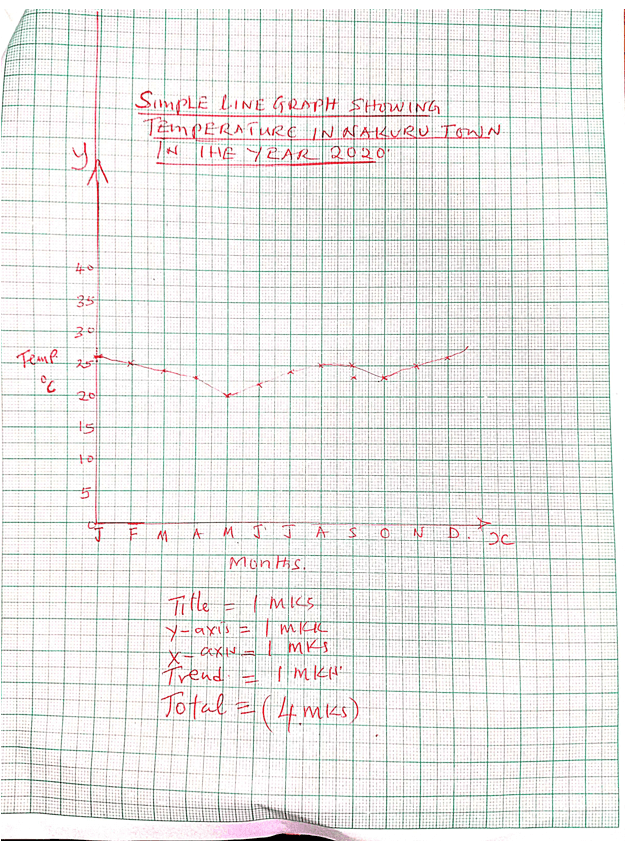
- The table below shows temperature distribution of Nakuru town in the year 2020.
Month
J
F
M
A
M
J
J
A
S
O
N
D
Temp OC
26
25
24
23
20
22
24
25
25
23
25
26
- Calculate the annual range of temperature from above data. (2mks)
- Using scale 1cm rep 5ºC. Draw a simple line graph to present the information in the table above. (5mks)
MARKING SCHEME
-
- Give two layers of discontinuity found in the internal layers of the earth. (2mks)
- Mohorovicic discontinuity
- Gutenberg discontinutity
- State three characteristics of the mantle. (3mks)
- Mantel is made up of two layers the upper mantle and lower mantle.
- Mantle is composite of silicate rocks
- The dominant minerals is olivine, and femomagnesian silicate.
- The mantle has density ranging between 30. – 3.3gm/cc.
- The mantle have high temperature of 5000ºC
- Give two layers of discontinuity found in the internal layers of the earth. (2mks)
-
- Name two forms of precipitation. (2mks)
- Dew
- Frost
- Snow
- Mist and frost
- Rainfall
- Sleet and hail
- Study the diagram below and answer the questions that follow.
- Identify the diagram above. (1mk)
- Anemometer
- Describe how the instrument is used in the weather station. (4mks)
- It is used to measure the speed of wind.
- Anemometer consists of three or four metal cups fixed to metal arm, that rotate freely on vertical shaft.
- When wind blows, the cups rotate.
- The stronger the wind the faster the rotation.
- The number of rotation is recorded on a meter to give the speed of the wind in kilometer per hour.
- Identify the diagram above. (1mk)
- Name two forms of precipitation. (2mks)
-
- Define the term mineral. (2mks)
- Mineral are naturally occurring crystalline, inorganic substance with a definite chemical composition and physical properties.
- Explain three forms of metamorphism. (6mks)
- Contact metamorphism which is caused by the action of heat, gases and chemical solution.
- Dynamic metamorphism which is caused by the action of great pressure.
- Regional metamorphism which involving relatively high and temperature.
- Define the term mineral. (2mks)
-
- Name three causes of earth movement. (3mks)
- Magma movement
- Gravitational forces
- Conventional currents
- Isostatic adjustment
- Give three features formed as a result of horizontal earth movements. (3mks)
- Faults
- Rift valleys
- Basins
- Fault scarps
- Fault blocks
- Tilt block
- Block mountain
- Name three causes of earth movement. (3mks)
-
- Study the diagram below and answer the questions that follow.
- Identify the features represented by the above diagrams. (1mk)
- Complex cones (stratified and parasitic )
- Name parts marked X, Y, Z. (3mks)
- X – Main vent
- Y- parasitic cone
- Z -cinder
- Describe how the feature named above is formed. (3mks)
- Vent type eruption can build simple cones or complex cone.
- Repeated eruption can cause stratified cone with successive layer of cash, cinder and magma.
- Sometime the vent branches and results in the formation of parasitic cone.
- Example Mt Longonot.
- Identify the features represented by the above diagrams. (1mk)
- You are to carry out field study on volcanicity on Mt. Longonot in Kenya.
- Give three methods of collecting data. (3mks)
- Interviewing
- Sampling
- Observation
- Experimentation
- State the follow-up activities for the field. (3mks)
- Writing a report on data collection.
- Displaying photographs taken during the study.
- Conducting a discussion based on data collection.
- Giving a lecture to other student.
- Give three methods of collecting data. (3mks)
- Study the diagram below and answer the questions that follow.
-
- Explain constructive consequences of vulcanicity to human activities. (6mks)
- Volcanic activities result into large volcanoes which form cool, watered highland areas for Agriculture.
- Volcanic activity form scenic beauty which attract tourist, earn foreign exchange.
- Volcanic activities sometime results in the formation of rich metallic minerals which are mined to provide income.
- Give three human activities that causes earthquakes. (3mks)
- Explosions resulting from underground nuclear tests.
- Trains and explosive used in quarry.
- Constriction of large reservoirs.
-
- State two modern methods of showing direction on maps. (2mks)
- Use of points of compass
- The use of bearing.
- State four ways of locating places on a map. (4mks)
- Use of direction, bearing and distance.
- By use of place names
- By use of latitudes and longitudes
- By use of grid reference system
- Name three methods of representing relief on topographical maps. (3mks)
- Contours
- Form lines
- Hachuner
- Spot heights and trigonometrically station
- Hell shading
- Coloring
- Cliff and rock drawing.
- State two modern methods of showing direction on maps. (2mks)
- Explain constructive consequences of vulcanicity to human activities. (6mks)
-
- What is a photograph? (2mks)
- Photograph is an image of an object, person or scene in form of a print or slide recorded by a camera on a film and later transferred onto specially prepared paper.
- Explain three parts of a photograph. (6mks)
- Foreground this is the part nearest to the camera
- Middle ground this is the part in the centre of a photograph.
- Background this is part furthest from the camera.
- What is a photograph? (2mks)
- The table below shows temperature distribution of Nakuru town in the year 2020.
Month
J
F
M
A
M
J
J
A
S
O
N
D
Temp ºC
26
25
24
23
20
22
24
25
25
23
25
26
- Calculate the annual range of temperature from above data. (2mks)
- 26ºC – 20ºC
- = 6ºC
- Using scale 1cm rep 5ºC. Draw a simple line graph to present the information in the table above. (4mks)
- Calculate the annual range of temperature from above data. (2mks)
Join our whatsapp group for latest updates
Tap Here to Download for 50/-
Get on WhatsApp for 50/-
Download Geography Questions and Answers - Form 2 End Term 1 Exams 2022.
Tap Here to Download for 50/-
Get on WhatsApp for 50/-
Why download?
- ✔ To read offline at any time.
- ✔ To Print at your convenience
- ✔ Share Easily with Friends / Students


