
Answer all the questions

QUESTIONS
- List three types of field work. (3mks)
- Give four methods of data presentation. (4mks)
- State four negative effects of mining on the environment? (4mks)
- State four economic importance of minerals in Kenya. (4mks)
- The diagram below show the occurrence of a fossil fuel
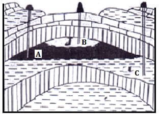
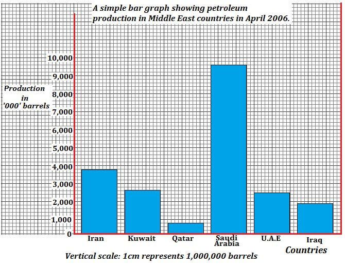
Name the substances in the area labeled A, B and C. (4mks) - The table below shows petroleum production in thousand barrels per day for countries in the Middle East in April 2006 use it to answer questions.
COUNTRY
PRODUCTION IN ‘000’ BARRELS
Iran
Kuwait
Qatar
Saudi Arabia
U.A.E
Iraq
3800
2550
800
9600
2500
1900
- What in the difference in introduction between the highest and the lowest producer. (1mk)
- What is the total amount of petroleum produced in April 2006 in the region?(2mks)
- What is the mean of petroleum produced in the April 2006 in the region? (3mks
- Draw a simple bar graph to represent the data in the table above. Use a scale of 1cm represents 1,000,000 barrels. Use the graph paper provided. (7mks)

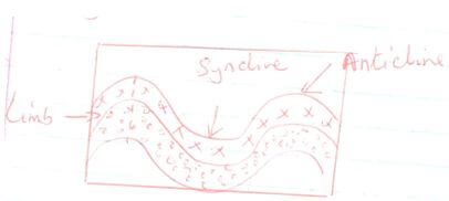
- Draw a diagram to show a simple field and on it mark and name;
- An anticline
- A limb
- Syncline. (4 marks)
- The diagram above represents features as vulcanicity. Use it to answer the question that follows;
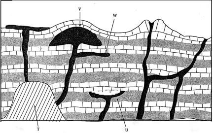
- Name the features labeled T, U, V and W (4mks)
- Differentiate between magma and lava. (2mks)
- Name two fold mountain in Africa. (2mks)
- What is a photograph? (2mks)
- State three characteristics of ground general view photographs. (3mks)
- What is climate? (2mks)
- Give four factors influence climate. (4mks)
- The diagram below shows the climatic regions of Kenya.
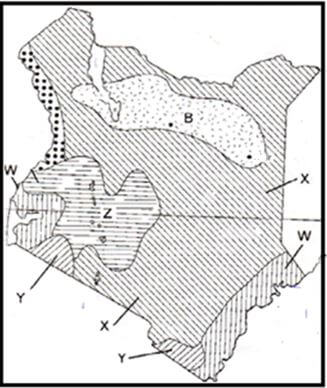
- Identify the climatic regions marked W, X, Y and Z. (4mks)
- Describe the characteristics of climate region marked B. (5mks)
-
- Differentiate between natural vegetation and secondary vegetation. (2mks)
- Outline four factors that influence the distribution and type of natural vegetation in Kenya. (4mks)
Marking scheme
- List three types of field work. (3mks)
- Field study/ Field teaching
- Field excursion
- Field work research
- List four methods of data presentations. (4mks)
- Drawing graphs and Charts
- Drawing Sketch maps and diagrams
- Displaying the completed questionnaires
- Playing the taper
- Writing a report
- Giving a report
- Giving a lecture
- Displaying the labeled samples
- What are the negative effects of mining on the environment? (4mks)
- Mining causes land destruction/ugly land.
- Mining causes pollution of environment air , water, soil and also noise
- Mining causes loss of bio diversity animal migrate , vegetation cleared
- Leads to soil erosion since land remains bare
- Mining may lead to landslides
- Mining may lower the water table of a given place.
- State four significance of mineral in Kenya. (4mks)
- Minerals provide raw material for industries
- Minerals lead to development of transport and communication eg road, railways mining creates employment
- Minerals leads to development of settlement/ town eg Magadi town
- Minerals are exported to earn foreign exchange
- Mining leads to development of social amenities eg Hospital school
- Name the substances in the area labeled A, B and C. (4mks)
- A – Crude oil
- B – Natural Gas
- C – Water
- The table below shows petroleum production in thousand barrels per day for countries in the Middle East in April 2006 use it to answer questions.
COUNTRY
PRODUCTION IN ‘000’ BARRELS
Iran
Kuwait
Gator
Saudi Arabia
United Arab
Iraq
3800
2550
800
9600
2500
1900
- What in the difference in introduction between the highest and the lowest producer. (1mk)
- 9600 – 800 = 8800,000 barrels
- What is the total amount of petroleum produced in April 2006 in the region? (2mks)
- 21,150,000 barrels
- What is the mean of petroleum produced in the April 2006 in the region. (3mks)
- 21,150, 000 /6 =3,525,000 barrels
- Draw a simple bar graph to represent the data in the table above. Use a scale of 1cm represents 200,000 barrels. (7mks)
- What in the difference in introduction between the highest and the lowest producer. (1mk)
- The diagram above represents features as vulcanicity. Use it to answer the question that follows;
- Name the features labeled N,K,L and M (4mks)
- T – Batholich
- U – Lopolith
- V – Laccolith
- W – Sill
- Differentiate between lava and magma. (2mks)
- Magma refers to very hot molten material that is still below the surface of the earth while lava refers to very hot molten material that is flowing on the earth’s surface
- Name the features labeled N,K,L and M (4mks)
- In your answer booklet, draw a diagram to show a simple field and on it mark and name;
- An anticline
- A limb
- A syncline (4 marks)
- Name two fold mountain in Africa. (2mks)
- Atlas
- Cape Ranges
- What is a photograph? (2mks)
- Photograph is an image or a picture of an object recorded by a camera on a light sensitive firm or paper.
- State three characteristics of ground general view photographs (3mks)
- The camera focuses on many objects.
- The horizon is seen on the background clearly.
- Objects become progressively smaller towards the background.
- The camera captures the general appearance of an area/scene
- Dead ground is an area hidden from the eye of the camera
- What is climate? (2mks)
- Climate is the average weather conditions of a place which have been observed and recorded over a long period of the usually 30 – 35years.
- Name four factors influence climate. (4mks)
- Warm ocean current
- Latitude
- Distance from the sea
- Configuration of the coastline
- Air masses
- Aspect
- Human activities
-
- Name the seven climatic types shown in the diagram above. (4mks)
- W - Modified equatorial climate.
- X – Tropical continental climate.
- Y – Tropical Climate.
- Z - Modified tropical climate of the highlands
- Describe the characteristics of climate zone marked B. (5mks)
- The climate region marked B is tropical desert climate
- Very high day temperatures in some areas up to 35ºc
- Low night temperatures due to maximum terrestrial radiation
- Large diurnal temperatures due to maximum terrestrial radiation.
- Cloudless skies thus intense insulation and maximum terrestrial radiation.
- Very low rainfall less than 250mm annually
- Flash floods at times occur due to sporadic rains.
- Dry north east trade winds which bring no rain
- Sandstorms are common.
- Name the seven climatic types shown in the diagram above. (4mks)
-
- Differentiate between natural vegetation and secondary vegetation. (2mks)
- Natural vegetation refers to plant cover that grows in the wild/on its own without any interference by people or animals whereas secondary vegetation refers to plant cover that grows on its own after original vegetation has been cleared by people.
- Outline four factors that influence the distribution and type of natural vegetation in Kenya. (4mks)
- Variations in rainfall.
- Variations in temperature.
- Variations in soil.
- Variations in drainage.
- Variations in aspect.
- Human activities such as clearance of land.
- Differentiate between natural vegetation and secondary vegetation. (2mks)
Join our whatsapp group for latest updates
Tap Here to Download for 50/-
Get on WhatsApp for 50/-
Download Geography Questions and Answers - Form 2 End Term 2 Exams 2022.
Tap Here to Download for 50/-
Get on WhatsApp for 50/-
Why download?
- ✔ To read offline at any time.
- ✔ To Print at your convenience
- ✔ Share Easily with Friends / Students


