
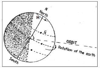
- The diagram below represents the earth on its axis
-
- Name the latitudes marked G and H (2marks)
- What is the angle of inclination of the earth’s axis to its orbit? (1marks)
- According to the diagram, which season is being experienced in the Southern hemisphere? (1mark)
- State four effects of the movement of the earth on its own axis (2marks)
-
-
- What is a Stevenson’s screen? (2marks)
- Give reason for the following characteristics of a Stevenson screen
- Double boarded roof material (2marks)
- Raised to about 1.2 metres (2marks)
- Metallic stands (2marks)
-
- Define the term mining (2marks)
- Give three formations in which minerals occur (3marks)
- Explain three contributions of petroleum production in Middle East countries (6marks)
- Suppose you were to carry out a field study on rocks in the area surrounding your school
- State three characteristics that you would look for while identifying different rock types (3marks)
- Give three appropriate methods that you would use to collect data. (3marks)
- State three follow up activities for the field study (3marks)
- The world map below shows the location of some fold mountains
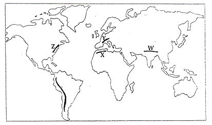
- Identify the fold mountains marked W, X, Y and Z (4marks)
- Explain the effects of Fold Mountains on the following
- Transport (2marks)
- Agriculture (2marks)
- Tourism (2marks)
- Name three example of active volcanoes in Africa (3marks)
- Differentiate between seismic focus and epicenter (2marks)
- State four human activities that may cause earthquakes (4marks)
- With the aid of well labeled diagrams, describe how a rift valley is formed due to tension forces (8marks)
-
- What is a photograph? (2marks)
- Name three types of ground photographs (3marks)
- State three characteristics of aerial oblique photographs (3marks)

MARKING SCHEME
- The diagram below represents the earth on its axis
- Name the latitudes marked G and H (2marks)
- G-tropic of cancer
- H- Arctic circle
- What is the angle of inclination of the earth’s axis to its orbit? (1marks)
- 66½°
- According to the diagram, which season is being experienced in the southern hemisphere?
- Winter (1mark)
- Name the latitudes marked G and H (2marks)
- State four effect of the movement of the earth on its own axis (2marks)
- Occurrence of day and night
- Deflection of winds and ocean currents
- Time differenced within longitudes
- Variations in atmosphere pressure at different latitudes
- What is a Stevenson’s screen? (2marks)
- A Stevenson’s screen is a white wooden box found in a weather station where thermometers are kept
- Give reason for the following characteristics of a Stevenson screen
- Double boarded roof material (2marks)
- The air space in between the double board is a poor conductor of heat thus thermometer is kept.
- Raised to about 1.2 metres (2marks)
- To prevent contact with the hot ground and to allow free entry and circulation of air
- Metallic stands (2marks)
- To prevent terminates from destroying the wooden part at the top
- Double boarded roof material (2marks)
- What is a Stevenson’s screen? (2marks)
- Define the term mining (2marks)
- Mining refers to the process of extracting valuable minerals and fossils fuels on or from the earth’s crust
- Give three formations in which minerals occur (3marks)
- As veins and lodes
- As beds and seam /layers
- As alluvial deposits
- As weathered products
- As evaporates
- Explain the contributions of petroleum production in Middle East countries
- Middle East countries earn foreign exchange from exports of crude oil and refined petroleum products e.g Saudi Arabia
- The petroleum industry provides employment opportunities to many people who earn income thus improving their standards of living.
- Revenues obtained from the sale of petroleum has enabled Middle East countries to develop efficient roads, railways health and education institutions.
- Development of petro-chemical industries in the countries which also employ many people.
- Oil wealth has enabled some countries to construct nuclear power stations for electricity supply.
- Petroleum production has led to the growth of modern sites within the Arabian and Iranian deserts such as Dubai, Riyath Abu Dhabi and Doha.
- Define the term mining (2marks)
- Suppose you were to carry out a field study on rocks in the area surrounding your school
- State three characteristics that you would look for while identifying different rock types (3marks)
- The hardness of the rocks
- The density of the rocks
- Texture of the rocks
- Colour of different rocks
- Luster of the minerals farming the rock
- Shape of the rock crystals
- Give three appropriate methods that you would look for while identifying different rock types (3marks)
- Collecting samples
- Digging
- Observation
- Photographing
- Touching
- State three follow up activities for the field study (3marks)
- Writing a report in essay form
- Displaying photographs on rocks taken from the field
- Displaying labeled samples
- Laboratory testing of the mineral composition of some rocks collected
- Discussing the findings in groups
- Giving a lecture to the students who never went.
- State three characteristics that you would look for while identifying different rock types (3marks)
- The world map below shows the location of some fold mountains
- Identify the fold mountains marked W, X, Y and Z (4marks)
- W -Himalays
- X- Atlas
- Y - Alps
- Z - Appalachians
- Explain the effects of Fold Mountains on the following
- Transport (2marks)
- Fold mountain scenery acts as a barrier to easy construction of roads, railways and pipelines thus making it difficult to access some regions due to ruggedness.
- Agriculture (2marks)
- Leeward slopes of some fold mountain ranges receive dry winds leading to arid conditions. This discourages crop farming but favours ranching and transhumance
- Windward slopes of most fold mountains receive high orographic rainfall which supports crop farming
- Tourism (2marks)
- Fold mountain scenery and snow capped slopes are important tourist attractions with some slopes favouring winter sports such as skiing and ice skating, e.g Swiss Alps
- Transport (2marks)
- Identify the fold mountains marked W, X, Y and Z (4marks)
- Name three example of active volcanoes in Africa (3marks)
- Nyiragongo
- Nyamlagira
- Oldonyo Lengai
- Teleki
- Likaiyu
- Differentiate between seismic focus and epicenter (2marks)
- Seismic focus is the point inside the earth’s crust where an earthquake originates whereas epicenter is the point on the earth surface directly above the seismic focus.
- State four human activities that may cause earthquakes (4marks)
- Underground testing of thermo-nuclear bombs
- Construction of dams which result in large reservoirs
- Use of very powerful explosions during quarrying and mining
- Movements of trains especially in subways.
- Name three example of active volcanoes in Africa (3marks)
- With the aid of well labeled diagrams, describe how a rift valley is formed due to tension forces (8marks)
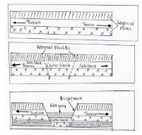
- Layers of rocks are subjected to tension forces
- This leads to the formation of two adjacent and parallel normal faults.
- Further tension pulls apart the two side blocks as the centre block gradually sinks to a lower level.
- Sinking of the centre block exposes the fault plane which forms escarpments on the sides.
- The sunken centre block forms the floor of the rift valley
- What is a photograph? (2marks)
- A photograph is an image of an object which is recorded by a camera on alight sensitive film, paper or a memory card.
- Name three types of ground photographs (3marks)
- Ground close ups
- Ground general view
- Ground oblique
- State three characteristics of aerial oblique photographs
- Covers large areas
- Objects on the foreground appear larger and decrease in size towards the background
- The horizon may be covered.
- What is a photograph? (2marks)
Join our whatsapp group for latest updates
Tap Here to Download for 50/-
Get on WhatsApp for 50/-
Download Geography Questions and Answers - Form 2 End Term 1 Exams 2023.
Tap Here to Download for 50/-
Get on WhatsApp for 50/-
Why download?
- ✔ To read offline at any time.
- ✔ To Print at your convenience
- ✔ Share Easily with Friends / Students


