
SECTION A:
Answer ALL questions in this section in the spaces provided.
-
- Define the term environment. (2mks)
- State two types of environment. (2mks)
- Highlight three sources of pollution in the environment. (3mks)
-
- Identify three factors that influence the exploitation of minerals. (3mks)
- Name the area where the following minerals are mined in Kenya.
- Diatomite. (1mk)
- Salt (1mk)
-
- Distinguish between forest and forestry. (2mks)
- Identify three activities that may be undertaken in your school to conserve trees. (3mks)
- The table below represents the rainfall and temperature data of station for one year.
Study it and answer the questions that follow.
Month J F M A M J J A S O N D Rainfall in (mm) 5 10 33 40 60 100 75 40 30 15 5 5 Temp(°C) 23 24 25 27 27 29 28 27 26 25 24 24 - Calculate the following;
- Annual temperature range. (2mks)
- Mean monthly temperature. (2mks)
- Annual rainfall. (2mks)
- Calculate the following;
- Differentiate between field study and an excursion. (2mks)
SECTION B:
Answer ALL Questions in this particular section
- Name the major natural forests of the world. (3mks)
- Explain four factors that influence distribution of natural forests.(8mks)
- Highlight comparisons softwood forests in Kenya and Canada. (6mks)
- State three species of softwood found in Kenya and Canada respectively. (3mks)
- Explain two problems facing forestry in Kenya. (4mks)
- State one importance of forest exploitation in Kenya. (1mk)
- Study the table below of a station B in a month of July and answer the following questions.
NE E S N SW SE W NW CALM 3 1 2 3 7 1 6 4 4 - Use a suitable cartographic technique to represent the data. (8mks)
-
- State advantages of using the method in (a) above to represent the data. (4mks)
- State the disadvantages of using the method. (3mks)
- State five significances of statistics. (5mks)
- Name three methods of recording statistical data. (3mks)
- Differentiate between primary and secondary data. (2mks)
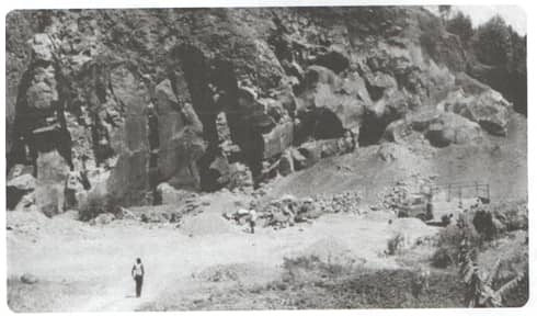
- Study the photograph below and answer the questions that follow.
-
- Name the mining method shown in the photograph. (1mk)
- Describe how minerals are obtained using the method shown in the photograph. (5mks)
- Using evidence from the photograph suggest the time of the day when the photograph is likely to have been taken. (2mks)
- Apart from the method shown in the photograph, name four other mining methods. (4mks)
- Name three problems the method used in the photograph can cause to the environment. (3mks)
- Explain five ways in which Kenya has benefited from the mining of soda ash in Lake Magadi. (10mks)
-

Marking Scheme
-
- Define the term environment. (2mks)
- Environment is the external conditions that surround living things influencing their activities and behavior.
- State two types of environment. (2mks)
- Physical environment.
- Human environment.
- Highlight three sources of pollution in the environment. (3mks)
- Noise from industries – causing noise pollution.
- Exhaust from industries – causing air pollution.
- Floods/runoff – causing water pollution.
- Plastics/plastic bags – causing soil pollution.
- Define the term environment. (2mks)
-
- Identify three factors that influence the exploitation of minerals. (3mks)
- Value of minerals
- Size of the mineral deposit
- The quality of ore.
- Method of mining
- Technology.
- Capital.
- Market
- Transport cost.
- Name the area where the following minerals are mined in Kenya.
- Diatomite. (1mk)
- Kariandusi – near Gilgil
- Gicheru in Nyandarua.
- Salt (1mk)
- Lake Magadi
- Shores of Indian Ocean/Ngongoni near Malindi.
- Diatomite. (1mk)
- Identify three factors that influence the exploitation of minerals. (3mks)
-
- Distinguish between forest and forestry. (2mks)
- Forests can be defined as a continuous and extensive land covered with closed stand of tall trees while forestry is the science of developing or cultivating forests.
- Identify three activities that may be undertaken in your school to conserve trees. (3mks)
- Carry out public campaigns on the value of trees in school.
- Advocating use of other sources of fuel to reduce overdependence on wood fuel.
- Carrying out afforestation programmes in school compound.
- Distinguish between forest and forestry. (2mks)
- The table below represents the rainfall and temperature data of station for one year.
Study it and answer the questions that follow.
Calculate the following;- Annual temperature range. (2mks)
Range: Maximum temperature – minimum temperature. - Mean monthly temperature. (2mks)
Maximum temp + minimum temp. divide by 2 - Annual rainfall. (2mks)
Sum total of rainfall received in a year divide by 12 months.
- Annual temperature range. (2mks)
- Differentiate between field study and an excursion. (2mks)
- Field study is aimed at collecting data in order to achieve specific objectives while an excursion is a sight-seeing outing, mainly aimed at relaxing the people involved.
SECTION B:
Answer ALL Questions in this particular section
-
- Name the major natural forests of the world. (3mks)
- Tropical Hardwood forests
- Temperate Hardwood forests.
- Coniferous forests.
- Explain four factors that influence distribution of natural forests.(8mks)
- Climate:
- Very cold conditions discourage growth of forests especially on upper slopes of mountains. High temperature and high rainfall encourage growth of natural forests.
- Altitude.
- Altitude affects temperature and rainfall low temperature results in slower growth and smaller size while high temperatures produce more luxuriant growth.
- Topography
- Forests do not grow on steep mountains where the surface is bare rock, the soils are thin and temperatures are low. Windward side supports forestry while leeward side discourages forestry.
- Soils
- Deep soils support greater tree growth while shallow soils do not, fertile soils support growth of trees unlike unfertile soils.
- Human activities
- Illegal human activities such as deforestation, burning of charcoal discourage distribution of forests while activities like afforestation and re-afforestation encourage growth of trees.
- Climate:
- Highlight comparisons softwood forests in Kenya and Canada. (6mks)
KENYA CANADA Due to high temperatures, the trees grow faster. Low temperature discourage settlement and other forms of land use leaving forestry as the option. Good deep soils found in the Kenya highlands have made the trees do well in these areas. The thin soils found in the rugged terrain of Canada do not favour agriculture. Aspect of topography like relief influence the growth of trees. Windward of Mt. Kenya encourage growth of forests. Valley bottoms along the coast provides good sites for the poaper mills and clay which is used in smoothening the paper surface. - State three species of softwood found in Kenya and Canada respectively. (3mks)
- Kenya –
- Podo, African pencil, pines, cypress, fir and wattle trees
- Canada –
- Pines, spruce and forg.
- Kenya –
- Explain two problems facing forestry in Kenya. (4mks)
- Fire outbreaks leading to forest extinct.
- Pests and diseases affecting mainly exotic forests.
- State one importance of forest exploitation in Kenya. (1mk)
- Preservation of environment.
- Regulation of climate.
- Provide suitable habitats for wildlife.
- Major source of income.
- Raw materials for industrial use.
- Promotes tourism
- Provides firewood.
- Name the major natural forests of the world. (3mks)
- Study the table below of a station B in a month of July and answer the following questions.
- Use a suitable cartographic technique to represent the data. (8mks)
-
- State advantages of using the method in (a) above to represent the data. (4mks)
- Easy to construct
- It gives a good visual impression at a glance.
- Easy to read and interpret.
- It shows clearly the direction of wind and number of days wind blew in that direction.
- State the disadvantages of using the method. (3mks)
- Does not show wind speed or pattern of flow.
- It is difficult to extract numerical values for it involves use of scale.
- Does not show exact time/day when wind blew from particular direction.
- State advantages of using the method in (a) above to represent the data. (4mks)
- State five significances of statistics. (5mks)
- Provides summarized information.
- Shows changes through time.
- Used for planning purposes
- Used to predict future trends of events such as droughts.
- Shows relationship between geographical phenomena.
- It shows clear comparison between phenomena.
- Name three methods of recording statistical data. (3mks)
- Note taking
- Field sketching
- Photographing
- Labeling samples
- Tape recording
- Filling in questionnaires
- Tallying
- Tabulation
- Video-recording and filming.
- Differentiate between primary and secondary data. (2mks)
- Primary data involves first hand information while secondary data involves already stored researched information.
- Use a suitable cartographic technique to represent the data. (8mks)
- Study the photograph below and answer the questions that follow.
-
- Name the mining method shown in the photograph. (1mk)
- Open cast/ Open pit
- Describe how minerals are obtained using the method shown in the photograph. (5mks)
- This method is used where mineral deposits are located near the earth surface.
- The top layers of the earth and other material lying above the mineral are removed by use of machines.
- The machines (electric shovels) are used to dig up the mineral deposits.
- The hard rocks are blasted using explosives to make them easier to work on.
- The ore is loaded into trucks or lorries and transported to the factory for processing.
(each point 1 mark , max, 5 marks)
- Name the mining method shown in the photograph. (1mk)
- Using evidence from the photograph suggest the time of the day when the photograph is likely to have been taken. (2mks)
- The photograph is likely to have been taken in the morning hours. This is because the shadow is long and the west of the objects.
- Apart from the method shown in the photograph, name four other mining methods. (4mks)
- Drilling method
- Shaft method
- Solution method
- Drift/Adit method
- Dredging method.
(each point 1mark, max 4 marks)
- Name three problems the method used in the photograph can cause to the environment. (3mks)
- Causes soil erosion through deforestation and making the top soil loose.
- Noise and air pollution caused by blasting of rocks and the dust produced.
- Low productivity. The soil left after mining is infertile so it cannot be affectively used for agriculture production.
- After mining, if the land is not rehabilitated, the heaps of soil left behind and the deep pits make the area look ugly.
- May lead to landslides due to the loosening of the soil.
(each point 1 mark, max 3 marks)
- Explain five ways in which Kenya has benefited from the mining of soda ash in Lake Magadi. (10mks)
- Growth of magadi town/urbanization.
- Many people have settled in Magadi town. These are mostly people working in the mines and traders. Such settlement has encouraged the expansion of Magadi town.
- Uplifting of living standard.
- Social amenities such as schools, hospitals, social clubs piped water and electricity have been developed in the area. They have benefited the local community (Maasai) thus raising their living standards.
- Development of transport system.
- Transport links such as railway lines and tarmac roads have been constructed to connect the Magadi area with other places. This makes easy movement of people and goods possible, for example, the railway line connecting Konza to Magadi.
- Earns the country foreign exchange.
- The exportation of soda ash to other countries, earns Kenya a lot of money. This money is used to develop other sectors in the country such as the agricultural sector.
- Growth of magadi town/urbanization.
-
Join our whatsapp group for latest updates
Tap Here to Download for 50/-
Get on WhatsApp for 50/-
Download Geography Paper 2 Questions and Answers - Form 3 End Term 1 Exams 2021.
Tap Here to Download for 50/-
Get on WhatsApp for 50/-
Why download?
- ✔ To read offline at any time.
- ✔ To Print at your convenience
- ✔ Share Easily with Friends / Students


