
INSTRUCTIONS TO CANDIDATES:
- This paper consists of three sections; A, B and C.
- Answer all questions from section A and B.
- In section C, answer any three questions. All answers must be written on the answer sheets provided.
SECTION A:
Answer all the questions in this section.
-
- Name two types of earth movements. (2 mks)
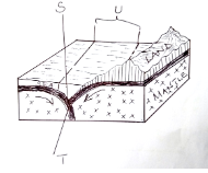
- The diagram below represents tectonic plate boundary. Name the areas marked S, T and U. (3 mks)
-
- Differentiate between seismic focus and epicenter. (2 mks)
- State two ways through which a river transports its load. (2 mks)
-
- Apart from exfoliation, name two other physical weathering processes influenced by temperature changes. (2 mks)
- Describe exfoliation process. (4 mks)
-
- State two ways through which a river transports its load. (2 mks)
- State three conditions necessary for the formation of a delta. (3 mks)
-
- The diagram below shows a process of slow mass wasting.
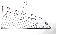
- Identify the process. (1 mk)
- Name the feature marked Y. (1 mk)
- State three conditions which may influence occurrence of landslides. (3 mks)
- The diagram below shows a process of slow mass wasting.
STUDY THE MAP OF YIMBO (1:50,000 SHEET 115/1) provided and answer the following questions
-
-
- Name two natural features found in grid square 3696. (2 mks)
- Give two types of scales used on Yimbo map. (2 mks)
- Give the six figure grid reference of the trigonometrical station point 1207 (115 1 27) (2 mks)
-
- Give the adjoining sheet found to the North-east of Yimbo map . (1 mk)
- Give the latitudinal and longitudinal extent of the area covered by the map extract. (2 mks)
- Identify three types of natural vegetation in the area covered by the map. (3 mks)
-
- Give three methods used to show relief in the area covered by the map. (3 mks)
- Give the height of the highest and the lowest points on the map. (2 mks)
- You are required to carry out a field study on economic activities carried out in the area covered by the map.
- Outline the ways in which you will pr e pare before the study. (5 mks)
- List the activities you will be involved in during the study. (3 mks)
-
-
-
- What is fog? (2 mks)
- State two conditions necessary for the formation of fog. (2 mks)
- With the aid of a labeled diagram, describe how relief rainfall is formed. (7 mks)
- Use the map of Africa below to answer the questions that follow.
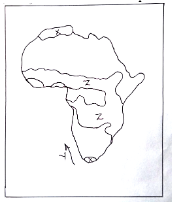
- Name, the type of climate experienced in the region marked X. (1 mk)
- The ocean current marked Y. (1 mk)
- Describe the characteristics of the type of climate found in the area marked Z. (6 mks)
- Suppose your class carried out a field study on weather around the school environment;
- Explain two effects of wind on climate that they are likely to have identified. (2 mks)
- Give two methods the class used to collect data in the field. (2 mks)
- Give two follow-up activities the class was involved in after the field study. (2 mks)
-
-
- Distinguish between magma and Lava. (2 mks)
- The diagram below shows intrusive volcanic landforms. Use it to answer the questions that follow.
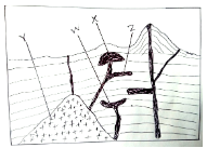
- Name the features marked W, X and Y. (3 mks)
- Describe how feature Z is formed (4 mks)
-
- Name two features that result from fissure eruption. (2 mks)
- List two types of lava. (2 mks)
-
- Describe how a composite volcano is formed. (6 mks)
- Explain the significance of volcanic features to human activities. (6 mks)
-
-
- Define Secondary Vegetation. (2 mks)
- State three climatic factors which influence the distribution and type of vegetation. (3 mks)
- Give three uses of mangrove trees. (3 mks)
- The diagram below represents zones of natural vegetation on a mountain slope. Use it to answer the questions that follow.
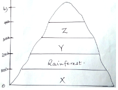
- Name the vegetation zones marked X, Y and Z. (3 mks)
- Describe the characteristics of the rainforest vegetation. (6 mks)
- You are required to carry out a field study on natural vegetation within your local environment.
- Give three types of information for your study. (3 mks)
- State three way s you would do to identify the different types of plants. (3 mks)
- State two ways in which the information collected during the study would be useful to the local community. (2 mks)
-
-
-
- Define the term Ocean. (2 mks)
- State three sources of salt in ocean water. (3 mks)
- State three factors which determine the temperature of the ocean water. (3 mks)
-
- Describe three processes of wave erosion. (6 mks)
- Name five features resulting from wave erosion. (5 mks)
- Your class is required to carry out a field study on wave erosion along the Kenyan coastline.
- Why would you need to carry the following?
- A mosquito net. (1 mk)
- Light clothes (1 mk)
- A bag ( 1mk)
- Explain reasons why you think your study will be important to the government of Kenya. (3 mks)
- Why would you need to carry the following?
-
MARKING SCHEME
SECTION A:
Answer all the questions in this section.
-
- Name two types of earth movements. (2 mks)
- Horizontal/Lateral/Orogenic earth movement
- Vertical/Epeirogenic earth movement.
- The diagram below represents tectonic plate boundary. Name the areas marked S, T and U. (3 mks)
- S – Oceanic trench
- T – Destructive/convergent/compressional boundary
- U - Subduction zone
- Name two types of earth movements. (2 mks)
-
- Differentiate between seismic focus and epicenter. (2 mks)
- Seismic focus is the origin of the shock waves inside the earth’s crust whereas epicenter is the point on the earth’s surface vertically above the focus.
- Name two types of surface longitudinal waves. (2 mks)
- Rayleigh waves
- Love waves
- Differentiate between seismic focus and epicenter. (2 mks)
-
- Apart from exfoliation, name two other physical weathering processes influenced by temperature changes. (2 mks)
- Block disintegration/Block separation
- Granular disintegration
- crystal growth
- frost action
- Describe exfoliation process. (4 mks)
- Occurs within rocks of uniform structure mainly in arid and semi-arid areas.
- During the day, temperatures are high and the rocks are heated on the surface and the inner part is coloer making the rock surface to expand.
- During the night, temperatures are lower and the rocks cool and contract on the surface.
- Continued expansion and contraction makes the rock surface to develop cracks which will break and peel off in cured sheets, this is exfoliation.
- Apart from exfoliation, name two other physical weathering processes influenced by temperature changes. (2 mks)
-
- State two ways through which a river transports its load. (2 mks)
- By solution
- By suspension
- By saltation/Hydraulic lift
- By traction/rolling
- State three conditions necessary for the formation of a delta. (3 mks)
- There must be large quantities of silt/sediments to be deposited at the river mouth
- There should be a shallow continental shelf/shore around the river mouth
- Higher rate of deposition than rate of removal of silt at the river mouth/presence of calm sea/weak sea waves/weak tidal currents at the coast.
- Absence of obstacles/filters in the river course such as swampy vegetation/marsh.
- State two ways through which a river transports its load. (2 mks)
-
- The diagram below shows a process of slow mass wasting.
- Identify the process. (1 mk)
- Solifluction/Solifluxion
- Name the feature marked Y. (1 mk)
- Saturated soil/rock debris
- Identify the process. (1 mk)
- State three conditions which may influence occurrence of landslides. (3 mks)
- Nature of materials on a slope
- Extent of saturation/Amount of precipitation
- Angle of the slope/Gradient of the land
- Human activities such as mining and building
- Occurrence of earthquakes/volcanic eruptions/isostatic adjustment.
- The diagram below shows a process of slow mass wasting.
STUDY THE MAP OF YIMBO (1:50,000 SHEET 115/1) provided and answer the following questions
-
-
- Name two natural features found in grid square 3696. (2 mks)
- River
- Scrub
- Scattered trees/woodland
- Give two types of scales used on Yimbo map. (2 mks)
- Ratio scale
- Linear scale
- Give the six figure grid reference of the trigonometrical station point 1207 (115 T 27) (2 mks)
- 329857
- Name two natural features found in grid square 3696. (2 mks)
-
- Give the adjoining sheet found to the North-east of Yimbo map . (1 mk)
- Ugenya (101/4)
- Give the latitudinal and longitudinal extent of the area covered by the map extract. (2 mks)
0°00’ – 0°15’S, 34°00’ – 34°15’E\
- Give the adjoining sheet found to the North-east of Yimbo map . (1 mk)
- Identify three types of natural vegetation in the area covered by the map. (3 mks)
- Scrub
- Scatteredd trees
- Thickets
- Papyrus swamp
-
- Give three methods used to show relief in the area covered by the map. (3 mks)
- Contours
- Trigonometrical stations
- Names of the relief features
- Give the height of the highest and the lowest points on the map. (2 mks)
- Highest point 1318m a.s.l
- Lowest point 1140m a.s.l
- Give three methods used to show relief in the area covered by the map. (3 mks)
- You are required to carry out a field study on economic activities carried out in the area covered by the map.
- Outline the ways in which you will pre pare before the study. (5 mks)
- Seeking permission from the relevant authorities
- Conducting a pre-visit to the area
- Holding class discussion on the topic
- Preparing a questionnaire
- Dividing the class into convenient groups
- Preparing methods of data collection/recording
- Formulating the objectives/Hypothesis of the study
- Preparing a working schedule
- Selecting relevant tools e.g. camera, a route map etc.
- List the activities you will be involved in during the study. (3 mks)
- Observation
- Taking photographs
- Interviewing people
- Administering a questionnaire
- Outline the ways in which you will pre pare before the study. (5 mks)
-
-
-
- What is fog? (2 mks)
- Mass of water droplets which are suspended in the lower atmosphere and reduces visibility to less than a kilometre.
- State two conditions necessary for the formation of fog. (2 mks)
- Abundant moisture in the air
- Air must be cooled below dew point
- The wind must be light/calm
- Clear sky to permit free terrestrial radiation.
- What is fog? (2 mks)
- With the aid of a labeled diagram, describe how relief rainfall is formed. (7 mks)
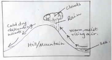
- A water body is heated causing evaporation of water
- Warm, moist air from the water body is forced to ascend a hill/mountain side
- Forced ascend leads to expansion and cooling of air
- The moisture in the air condenses forming clouds
- Rain falls mainly on the windward side of the hill/mountain.
- Use the map of Africa below to answer the questions that follow.
- Name, the type of climate experienced in the region marked X. (1 mk)
- Mediterranean
- The ocean current marked Y. (1 mk)
- The cold Bengula current
- Describe the characteristics of the type of climate found in the area marked Z. (6 mks)
- Moderate rainfall/750 – 1000mm
- Rainfall is mainly convectional
- Rain falls during the hot season
- Rainfall amounts decreases in places away from the equator.
- High temperatures throughout the year/ 22°C – 32°C
- High annual range of temperature (11°C)
- The prevailing winds are mainly the trade winds
- There are two distinct seasons/wet and dry seasons
- Name, the type of climate experienced in the region marked X. (1 mk)
- Suppose your class carried out a field study on weather around the school environment;
- Explain two effects of wind on climate that they are likely to have identified. (2 mks)
- Winds from a warm region raise temperatures of the areas they blow to
- Winds from cold regions lower temperature of the areas they blow to
- Winds passing over moist regions pick moisture causing rainfall in areas they blow to
- Winds passing over dry areas remain dry causing dry conditions over the areas they blow to.
- Give two methods the class used to collect data in the field. (2 mks)
- Observation
- Photographing
- Counting
- Administering questionnaires
- Give two follow-up activities the class was involved in after the field study. (2 mks)
- Displaying photographs/items collected
- Discussing with the rest of the class
- Writing reports
- Analyzing the information collected
- Drawing diagram/charts
- Reading further on the topic
- Explain two effects of wind on climate that they are likely to have identified. (2 mks)
-
-
- Distinguish between magma and Lava. (2 mks)
- Magma is the hot molten rock in the interior of the earth while lava is the hot molten rock which reaches the surface of the earth.
- The diagram below shows intrusive volcanic landforms. Use it to answer the questions that follow.
- Name the features marked W, X and Y. (3 mks)
- W – Lopolith
- X – Laccolith (Laccolite)
- Y - Batholith
- Describe how feature Z is formed (4 mks)
- Formed when magma is forced along the horizontal lines/bedding planes of the crustal rocks.
- The intruding magma will then cool and harden/solidify horizontally along the bedding plane of the crustal rocks forming an intrusive volcanic landform.
- This is how a sill is formed.
- Name the features marked W, X and Y. (3 mks)
-
- Name two features that result from fissure eruption. (2 mks)
- Lava plateau
- Lava plains
- Tuff plateau
- List two types of lava. (2 mks)
- Acidic lava
- Basic lava
- Intermediate lava
- Ultra-basic lava
- Name two features that result from fissure eruption. (2 mks)
-
- Describe how a composite volcano is formed. (6 mks)
- High temperature and pressure inside the earth’s crust leads to the formation of magma.
- Earth’s movements leads to the formation of cracks in the crustal blocks
- Volcanic eruption occurs and pyroclasts are violently thrown out through the vent and settles around it.
- Another volcanic eruption of acidic lava occurs through the vent which cools and solidifies on top of the pyroclasts
- Successive eruption occurs and results in the accumulation of layers of pyroclasts and lava
- Magma cools, solidifies in the vent forming a plug that seals the vent
- High pressure builds up in the interior of the earth
- Magma escapes through a side vent, cools and solidify to form a parasitic cone.
- The cone-shaped feature formed of alternating layers of pyroclasts and lava is called a composite volcano.
- Explain the significance of volcanic features to human activities. (6 mks)
- Volcanic mountains receive high rainfall on their windward slopes which promotes agriculture
- Volcanic mountains, Hot springs and geysers provide beautiful scenery which promotes tourism
- Regions of volcanic activities yield valuable minerals which promotes mining
- Hotsprings and Geysers are sources of geothermal power.
- Some volcanic rocks such as phonolites and trachytes are used in building and construction industry.
- Volcanic mountains form water catchment areas and are sources of rivers.
- Volcanic rocks especially basalt weather down to form fertile soils which support crop farming
- Steep volcanic mountain slopes discourage settlement and development of transport/communication network.
- Volcanic mountains create a rain shadow effect on their Leeward sides causing aridity.
- Describe how a composite volcano is formed. (6 mks)
- Distinguish between magma and Lava. (2 mks)
-
-
- Define Secondary Vegetation. (2 mks)
- Plant cover that grows naturally in a place but has been interfered with by man/livestock/wild animals.
- State three climatic factors which influence the distribution and type of vegetation. (3 mks)
- Variation in temperature
- Amount of sunshine
- Duration of sunshine
- Nature and strength of the winds
- Variation in the amount of rainfall
- Give three uses of mangrove trees. (3 mks)
- wood is used as firewood
- Poles are used for Construction
- The bark is used for the extraction of tannin
- Define Secondary Vegetation. (2 mks)
- The diagram below represents zones of natural vegetation on a mountain slope. Use it to answer the questions that follow.
- Name the vegetation zones marked X, Y and Z. (3 mks)
- X - Savannah vegetation
- Y- Bamboo forest
- Z- Heath and moor land
- Describe the characteristics of the rainforest vegetation. (6 mks)
- The forest consists of mixed variety of tree species.
- Forests are evergreen/trees shed their leaves at different times of the year.
- The trees are tall/straight with large trunks.
- The trees have broad leaves
- The trees take long to mature
- The trees are mainly hard woods
- The trees are mainly close to each other
- Some trees have buttress roots
- Forest crowns form three distinct layers/canopies.
- Name the vegetation zones marked X, Y and Z. (3 mks)
- You are required to carry out a field study on natural vegetation within your local environment.
- Give three types of information for your study. (3 mks)
- Type of trees
- Age of the trees
- Height of the trees
- Uses of the vegetation
- Characteristics of the vegetation
- State three ways you would use to identify the different types of plants. (3 mks)
- By observing the colour of the leaves.
- By observing the leaf size/pattern
- By observing the root system
- By estimating the age of the plants
- By observing the height of the plants
- By feeling the texture of the leaves
- By observing the size of the stems/ trunks
- State two ways in which the information collected during the study would be useful to the local community. (2 mks)
- Can be used to plan agricultural activities.
- Can be used in the conservation of the environment.
- Can be used in the rationalization of land use.
- Can be used for future reference
- Can be used to determine the economic uses of plants.
- Give three types of information for your study. (3 mks)
-
-
-
- Define the term Ocean. (2 mks)
- A large and extensive mass/body of saline water occupying a basin between continents.
- State three sources of salt in ocean water. (3 mks)
- bedrocks of some oceans may contain salts which are dissolved by ocean water, thus increasing salinity
- volcanic eruptions may take place in the ocean beds thus bringing a lot of salt through the lava ejected.
- some rivers may dissolve salts along their valleys and transport them in solution form into oceans raising the salinity of the water.
- State three factors which determine the temperature of the ocean water. (3 mks)
- nature of the ocean currents
- Latitudinal position of Oceans
- The depth of an ocean
- Define the term Ocean. (2 mks)
-
- Describe three processes of wave erosion. (6 mks)
- Abrasion/corrosion
- Rocks fragments carried by waves are used as tools to grind the floor and the cliff face as the waves break / rock fragments carried by the backwash erodes the sea floor solution/corrosion
- The solvent and chemical action of the sea water dissolves and removes the soluble minerals that are found in the cliff/sea floor especially where there are limestone rocks.
- Hydraulic Action
- The breaking waves hit against the cliffs shattering the rocks/the force of breaking waves compress air into the joints/cracks in the cliff face. This enlarges the cracks and parts of the rocks may break off
- Attrition
- Particles that are carried by waves are constantly colliding. This wears them into smaller sizes.
- Abrasion/corrosion
- Name five features resulting from wave erosion. (5 mks)
- Bays
- Headlands
- Caves
- Blowholes
- Geos
- Arches
- Stumps
- Stacks
- Cliffs
- Wave cut platforms
- Describe three processes of wave erosion. (6 mks)
- Your class is required to carry out a field study on wave erosion along the Kenyan coastline.
- Why would you need to carry the following?
- A mosquito net. (1 mk)
- The Kenyan Coast is humid with mosquitoes thriving here.
- To protect ourselves from mosquito bites
- Light clothes (1 mk)
- The cost is hot and humid and therefore light clothes are the most suitable to wear.
- A bag (1mk)
- To carry back rock samples for analysis after the study.
- A mosquito net. (1 mk)
- Explain reasons why you think your study will be important to the government of Kenya (3 mks)
- To advise the government on the economic potential of the Kenyan Coast.
- To reveal to the government the areas that requires conservation.
- To sensitize the Coastal people on the aesthetic importance of such a heritage encouraging them to take advantage of tourist activities to earn a living.
- Why would you need to carry the following?
-
Join our whatsapp group for latest updates
Tap Here to Download for 50/-
Get on WhatsApp for 50/-
Download Geography Paper 1 Questions and Answers - Form 3 Term 2 Opener Exams 2023.
Tap Here to Download for 50/-
Get on WhatsApp for 50/-
Why download?
- ✔ To read offline at any time.
- ✔ To Print at your convenience
- ✔ Share Easily with Friends / Students


