
GEOGRAPHY
FORM 4
END TERM EXAMS
TERM 1 2021
PAPER 1
TIME 2¾ hrs
INSTRUCTIONS
- This paper has two sections : A and B
- Answer all the questions in section A
- Answer Question 6 and any other tow questions from Section B
SECTION A.
-
- Give three components of the solar system. (3mks)
- Identify two types of high level clouds. (2mks)
-
- Draw a well labeled diagram of a hydrological cycle. (5mks)
- What is weathering? (1mk)
-
- Give three factors that influence the rate of weathering. (3mks)
- The diagram below shows a composite volcano.
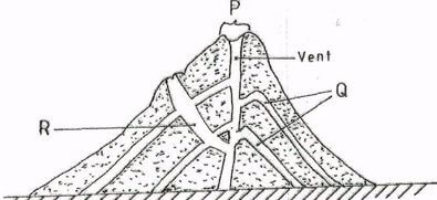
Name the feature marked P,Q and R. (3mks)
-
- How is a parasitic cone formed? (3mks)
- State three characteristics of the outer core in the interior structure of the earth. (3mks)
- Name the two layers of discontinuity that are part of the interior structure of the earth. (2mks)
SECTION B
Answer question 6 and any other two questions from this section.
Use the map of Busia ( 1:50,000) provided to answer the questions that follow
-
-
- Identify three physical features in grid square 2539. (3mks)
- Give the six – figure grid reference of the air-photo point at Kisoko along river Sio. (1mk)
- Give the approximate height of Nangoma hill in grid square 2838. (2mks)
- Measure the distance along the regional boundary from where it intersects, all-weathered road, loose surface number (526 to its intersection with road B8/3) give answer in kilometer. (2mks)
-
- Calculate the bearing of Nangina dispensary from the chief’s house in grid square 2531. (2mks)
- Calculate the area to the east of road B2/3 and C526 to the south of northing 40 excluding the area covered by thickets vegetation. Give the area in Km2. (2mks)
- Identify two drainage features along river sio. (2mks)
- Citing evidence from the map, give three social services provided in the area covered by the map. (6mks)
- Describe the relief of the area covered by the map. (5mks)
-
-
-
- What is a mineral? (2mks)
- Describe the following characteristics of minerals (6mks)
- Luster
- Colour
- Density
-
- Name two examples of extrusive igneous rocks. (2mks)
- Describe three ways in which sedimentary are classified. (9mks)
- Explain the significance of rocks to the economy of Kenya under the following sub headings. (6mks)
- Tourism
- Energy
- Water
-
- The maps below show the location of some mountain ranges.
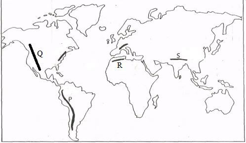
- Name the ranges marked P,Q,R and S. (4mks)
- Apart from fold mountains, name three other features resulting from folding. (3mks)
- With the aid of labeled diagram, describe how fold mountains are formed. (10mks)
- Explain the significance of fold mountains to human activities. (8mks)
-
-
- Outline two factors that influence the development of drainage patterns. (2mks)
- Outline five characteristics of a river in its youthful stage. (5mks)
- Describe the following processes of river erosion.
- Attrition (2mks)
- Corrosion (4mks)
- Explain three negative effects of rivers to the human environment. (6mks)
- Your class is planning to carry out a field study of a river in its old stage.
- State three reasons why it would be necessary to pre-visit the area ofstudy. (3mks)
- State the three activities you would carry out to determine why deposition occurs at this stage. (3mks)
-
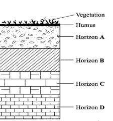
- The diagram below represents a well developed soil profile. Use it to answer question (a)
-
- Describe the characteristics of Horizon B. (3mks)
- Apart from humus, name three other components of soil. (3mks)
- State three ways in which humus contributes to the quality of soil. (3mks)
-
- Differentiate between soil structure and soil texture. (2mks)
- Explain how the following factors influence the formation of soil;
- Topography
- Time (6mks)
- Explain how the following farming practices may lead to loss of soil fertility.
- Overgrazing (2mks)
- Frequent ploughing (2mks)
- Continuous irrigation (2mks)
-

MARKING SCHEME
SECTION A.
-
- Give three components of the solar system. (3mks)
- The sun
- The planets
- Asteroids
- Comets
- Meteors
- Identify two types of high level clouds. (2mks)
- Cirrus
- Cirro-cumulus
- Cirro-stratus
- Give three components of the solar system. (3mks)
-
- Draw a well labeled diagram of a hydrological cycle. (5mks)

- What is weathering? (1mk)
- weathering is the breaking down/disintegration of rocks at or near the earth’s surface in situ by physical or chemical process.
- Draw a well labeled diagram of a hydrological cycle. (5mks)
-
- Give three factors that influence the rate of weathering. (3mks)
- Climate
- Nature of the rock
- Topography/angle of the slope
- Living organism
- Human activities
- Time
- The diagram below shows a composite volcano.
Name the feature marked P,Q and R. (3mks)- P – Crater
- Q – Lava layers
- R – Dyke
- Give three factors that influence the rate of weathering. (3mks)
-
- How is a parasitic cone formed? (3mks)
- Pressure is reduced causing the magma from the interior to reach the top of the volcano.
- The upper parts of the main vent of the volcano is blocked.
- Pressure pulls up the magma escape through aside vent.
- The successive out pouring of magma builds alternative layers of ash and lava to form a conelet on the side of the composite volcano.
- The cone let is the parasitic cone.
- State three characteristics of the outer core in the interior structure of the earth. (3mks)
- Outer cone is composed of molten rock material
- It is made up of iron and nickel
- It is estimated to be about 2100 km to 2890km
- It has temperature ranging from 3700ºC
- It has average density of 10.0gm/cc to 12.3gm/cc
- How is a parasitic cone formed? (3mks)
- Name the two layers of discontinuity that are part of the interior structure of the earth. (2mks)
- Mohorovicic
- Gutenburg
SECTION B
Answer question 6 and any other two questions from this section.
Use the map of Busia ( 1:50,000) provided to answer the questions that follow
-
-
- Identify three physical features in grid square 2539. (3mks)
- Papyrus swamp
- Plain plateus
- River Sio
- Give the six – figure grid reference of the air-photo point at Kisoko along river Sio. (1mk)
- 474385 + (1)
- 474385 + (1)
- Give the approximate height of Nangoma hill in grid square 2838. (2mks)
- Height of Nangoma hill
- Between 1321 – 1339 m
- Measure the distance along the regional boundary from where it intersects, all-weathered road, loose surface number (526 to its intersection with road B8/3) give answer in kilometer. (2mks)
- Distance 10.0 – 10.2 km
- Identify three physical features in grid square 2539. (3mks)
-
- Calculate the bearing of Nangina dispensary from the chief’s house in grid square 2531. (2mks)
- Bearing 255O, 254O,256O
- Bearing 255O, 254O,256O
- Calculate the area to the east of road B2/3 and C526 to the south of northing 40 excluding the area covered by thickets vegetation. Give the area in Km2. (2mks)
- area covered
full squares = 26 = 26km2
half squares = 19÷ ½ km = 9.5km2
total = 35.5 km2
subtract area covered by thicket.
Area covered by thicket 4 x ½ km2 = 2km235.5 – 2 = 33.5 km
+ 1km = (32.5 – 34.5 km2)
- area covered
- Identify two drainage features along river sio. (2mks)
- Numerous meanders
- Papyrus swamp
- Ox-bow lakes
- Riverine vegetation
- Seasonal swamp
- Calculate the bearing of Nangina dispensary from the chief’s house in grid square 2531. (2mks)
- Citing evidence from the map, give three social services provided in the area covered by the map. (6mks)
- Provision of education, presence of schools
- Provision of security , provision of religious services
- Presence of police post, provision of housing
- Provision of water, presence of dams.
- Describe the relief of the area covered by the map. (5mks)
- There is a ridge in the southern part of the map
- The south western part of the map is hilly.
- There are cols on top of samia ridge
- The highest point of the area covered by the map is 1568m at the apex of odiado hill.
- The lowest point in 1160m along the valley of river Sio.
- The rises from the north southwards
- There are many rivers valley
- River sio has a flood plain
-
-
-
- What is a mineral? (2mks)
- A mineral is an organic substance with a definite chemical composition at a mine beneath the surface of the earth.
- A mineral is an organic substance with a definite chemical composition at a mine beneath the surface of the earth.
- Describe the following characteristics of minerals (6mks)
- Luster - Mineral differ in the brightness depending on the nature of their reflective surface (smooth surface are shiny whereas rough are dull)
- Colour- Different minerals displays different colours
- Density- Mineral have different weight per unit volume of water. Minerals have different specific gravity / some minerals are heavy while others are light.
- What is a mineral? (2mks)
-
- Name two examples of extrusive igneous rocks. (2mks)
- basal
- pumice
- tuff
- rhyolite
- obsidian
- andsite
- tephra
- phonolite
- trachite
- Describe three ways in which sedimentary rocks are classified. (9mks)
- Mechanically formed sedimentary rocks – fragments are transported wind/water. They are deposited in layers. Over a long period of time. They are compacted into a hard rock.
- Organically formed sedimentary rocks dissolved minerals of plants animals are deposited in layers, over are then evaporated along period of time.
- Chemically formed sedimentary rocks where mineral particles are dissolved from land and are carried in solution from into water bodies such as lakes and seas.
- Name two examples of extrusive igneous rocks. (2mks)
- Explain the significance of rocks to the economy of Kenya under the following sub headings. (6mks)
- Tourism- Some rocks form unique features that attract tourisms earning the country foreign exchange.
- Energy- Some sedimentary rocks contains fossils fuels which are source of energy for domestic / industrial use.
- Water- Some rocks act as storage for water which can be supplied for domestics /industrial /agricultural.
-
- The maps below show the location of some mountain ranges.
- Name the ranges marked P,Q,R and S. (4mks)
- P – Ander
- Q – Appalachians
- R – Atlas
- S - Himalayas
- Apart from fold mountains, name three other features resulting from folding. (3mks)
- Synclinal valley (depression valleys)
- Ridges
- Intermontane basins
- Intermontane plateau
- With the aid of labeled diagram, describe how fold mountains are formed. (10mks)
- Extensive shallow depression called geosynline develop on the earth’s surface.
- Prolong and extensive erosion occurs in the surrounding higher grounds.
- Sediments are deposited in the geosynclines forming thick layers.
- The weight of the sediments cause subsidence of the geosyncline leading o accumulation of more sediments to greater thickness.
- Further subsidence of the geosynclines triggers off compressional forces which cause the sediments to fold.
- The folded layers of sediments in the geosynclines are thrust upwards to form fold mountains along the edges of the geosynclines due to closeness of the source of the forces.
- Explain the significance of fold mountains to human activities. (8mks)
- Fold mountains are sources of rivers that provide water for generation of H.E.P.
- Fold mountains are often forested and provide timber which is used in the building and construction industry.
- Some fold mountains have exposed valuable minerals deposits which are mined.
- Fold mountains are tourist attraction / snow covered slopes encourage, sporting activities .
- The wind ward slopes of fold mountain receive heavy precipitation which enhance agricultural activities.
- The rugged nature of some fold mountains created rain shadow effect which results into aridity discouraging crop farming.
- Name the ranges marked P,Q,R and S. (4mks)
-
-
- Outline two factors that influence the development of drainage patterns. (2mks)
- direction of the slope of the land.
- Difference in rock resistance hardness
- The arrangement of rocks layers
- Rock structure
- Faulting / fault guided.
- Outline five characteristics of a river in its youthful stage. (5mks)
- The river has a sleep river gradient
- The river channel is narrow
- The river has deep/steep – sided v-shaped valley
- The river flows as a high speed high stream velocity
- The ventricle erosion / down cutting is dominant
- The river channel is generally winding
- The river has a small load
- The river has a small volume of water
- Outline two factors that influence the development of drainage patterns. (2mks)
- Describe the following processes of river erosion.
- Attrition (2mks)- As rock materials are transported down stream. They constantly collide against each other. The material gradually wear down/reduce in size.
- Corrosion (4mks)- As solid rock material are transported down stream, they are hurled against the bank and dragged along the river bed.
- Explain three negative effects of rivers to the human environment. (6mks)
- When rivers flood, they destroy a lot of property/crops may displace people and may lead to loss of human life
- Wide/deep rivers are a barrier to transport especially where bridges have not been constructed.
- River water can be medium of spreading water born diseases, since flood water
- Your class is planning to carry out a field study of a river in its old stage.
- State three reasons why it would be necessary to pre-visit the area of study. (3mks)
- Help to asses the suitability of study area.
- Help to draw up objective/ hypothesis for the study
- It help to prepare route map
- It help to design a working schedule
- It help to estimate the cost of field study.
- Help to identify suitable data collection meeting
- Appropriate equipment to be used during the field study.
- State the three activities you would carry out to determine why deposition occurs at this stage. (3mks)
- Measuring out the nature of the load.
- Finding out the amount of the load
- Establishing the velocity of the river
- Observing obstacles in the stream channel
- Measuring of the width, depth of the river.
- State three reasons why it would be necessary to pre-visit the area of study. (3mks)
-
- The diagram below represents a well developed soil profile. Use it to answer question (a)
-
- Describe the characteristics of Horizon B. (3mks)
- It is accumulation zone for leaching minerals from horion A.
- The soil texture is clay in nature
- The zone sometime forms the hard pan/marram/lateric duri crust
- Apart from humus, name three other components of soil. (3mks)
- Water/soil water
- Rock particles/weathered materials
- Living organisms
- State three ways in which humus contributes to the quality of soil. (3mks)
- It helps improve soil texture
- It provide essential mineral to the soils from the decomposed plant matters.
- It enables soil to retain moisture
- It facilitate aeration of the soil
- Humus is a source of food for micro-organisms.
- Describe the characteristics of Horizon B. (3mks)
-
- Differentiate between soil structure and soil texture. (2mks)
- Soil structure is the way the individual soil particles are arranged into aggregate. Compound particles while soil texture is the degree of fineness or coarseness of the soil particles
- Soil structure is the way the individual soil particles are arranged into aggregate. Compound particles while soil texture is the degree of fineness or coarseness of the soil particles
- Explain how the following factors influence the formation of soil;
- Topography- Sleep slope encourages formation of deep fertile due to depositional. Valley bottoms encourages formation of deep fertile.
- Time (6mks)- Where soil formation processes takes a short duration the soils are generally immature / where the process has taken a long period of time soils are generally well developed/ mature.
- Differentiate between soil structure and soil texture. (2mks)
- Explain how the following farming practices may lead to loss of soil fertility.
- Overgrazing (2mks)- It leads to removal of vegetation cover thereby imposing soil to agents of erosion.
- Frequent ploughing (2mks)- This weakness soil structure making it easy for agents of soil erosion to carry it away.It increases oxidation which results in loss of organic matter.
- Continuous irrigation (2mks)- It causes leaching of soil nutrients making the top soil deficient of soluble minerals / cause salinity.
-
Join our whatsapp group for latest updates
Tap Here to Download for 50/-
Get on WhatsApp for 50/-
Download Geography Paper 1 Questions and Answers - Form 4 End Term 1 Exams 2021.
Tap Here to Download for 50/-
Get on WhatsApp for 50/-
Why download?
- ✔ To read offline at any time.
- ✔ To Print at your convenience
- ✔ Share Easily with Friends / Students


