
GEOGRAPHY
FORM 4
END TERM EXAMS
TERM 1 2021
PAPER 2
TIME 2¾ hrs
INSTRUCTIONS
- This paper has two sections : A and B
- Answer all the questions in section A
- Answer Question 6 and any other tow questions from Section B
SECTION A.
Answer all the questions in this section.
-
- State two ways in which minerals occur. (2mks)
- Describe panning as a method of mining. (3mks)
-
- Differentiate between a forest and forestry. (2mks)
- Give three characteristics of tropical hard wood forest. (3mks)
-
- Name two main rivers which supply water to mwea tebere irrigation scheme . (2mks)
- State three environmental problems faced by farmers in Mwea – Tebere Irrigation scheme. (3mks)
-
- State two factors that lead to the development of nucleated settlement patterns. (2mks)
- Identify two differences in the function of Nairobi and New York. (4mks)
-
- Identify two methods used to control tsetse flies in Kenya. (2mks)
- State three negative effects of uncollected garbage on the environment. (2mks)
SECTION B
Answer question 6 and any other two questions from this section.
-
- Study the diagram below and answer the questions that follow.
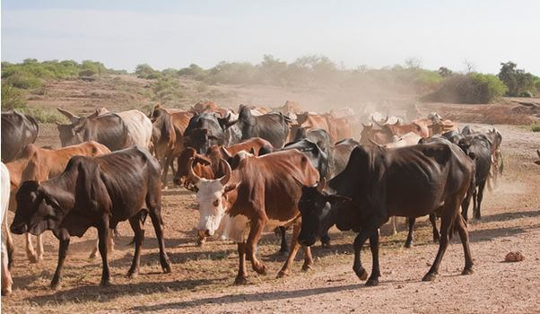
- Name the type of photograph shown above. (1mk)
- What time of the day was the photograph taken if the camera was held facing south? (1mk)
- Draw a rectangle measuring 16cm by 9cm to represent the area of the photograph. On it sketch and label the main features shown on the photograph. (5mks)
- Describe the landscape of the area represented by the photograph. (3mks)
-
- Identify two counties in the Rift Valley where ranching is practiced. (2mks)
- Name one exotic breed of beef cattle reared in Kenya. (1mk)
- State four physical factors which favour beef farming in Argentina. (4mks)
- Explain four benefits of beef farming to the economy of Argentina. (8mks)
- Study the diagram below and answer the questions that follow.
-
-
- What is agro-forestry? (2mks)
- Give four reasons why agro-forestry is encouraged in Kenya. (4mks)
- Use the map of Kenya below and answer the questions that follow.
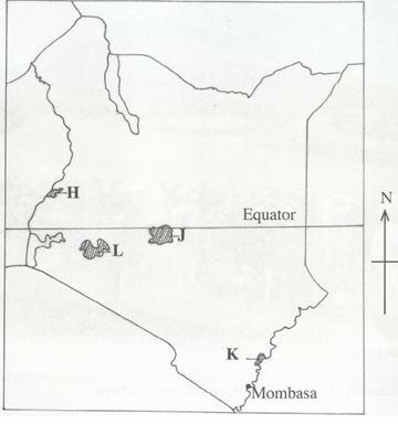
- Name the forest reserves marked H, J and K. (3mks)
- Explain four factors that favour the growth of natural forest in the area marked L. (8mks)
- Explain four problems facing forestry in Kenya. (8mks)
-
-
- What is mixed farming? (2mks)
- State three economic factors influencing agriculture. (3mks)
-
- Give four physical factors influencing coffee growing in Kenya. (4mks)
- Describe coffee production in Kenya from harvesting to marketing. (8mks)
- Give three differences between coffee farming in Kenya and Brazil.(6mks)
- You intend to carry out field study of coffee growing in a farm near your school. State two disadvantages of using secondary data during data collection. (2mks)
-
- Identify three sources of renewable energy. (3mks)
-
- Name three main hydroelectric power stations along the river Tana. (3mks)
- Apart from providing electric power, state four other benefits of the dam along the River Tana. (4mks)
- Identify two problems that affect the production of power along river Tana. (2mks)
- Explain four measures the Government of Kenya has taken to conserve energy. (8mks)
- Some students carried out field study on sources of energy by sampling the households around the school.
- Identify two sampling technique the students may have used during the study. (2mks)
- Give three advantages of sampling the households for the study. (3mks)
-
- Differentiate between a rural settlement and an urban centre. (2mks)
- Explain how the following physical factors influence human settlement.
- Relief (6mks)
- Climate (4mks)
- Explain the causes of the following problems in urban centres in Kenya.
- Traffic congestion (4mks)
- Environmental degradation (4mks)
-
- Name two towns in Kenya that started as agricultural collection centres . (2mks)
- Give three social functions of Kisumu town. (3mks)

MARKING SCHEME
SECTION A.
Answer all the questions in this section.
-
- State two ways in which minerals occur. (2mks)
- minerals may occur in beds and seams
- minerals may occur as weathered products
- minerals may occur in alluvial or placer deposits
- Describe panning as a method of mining. (3mks)
- this methods involves digging out the sand/gravel which contains mineral particles and mixed with water from the river in a shallow pan.
- The mixture is then whirled such that the lighter particles of sand/gravel are pushed on the sides of the pass while the heavier mineral particles are at bottom of the pan which are easily removed by hand as the waited mineral.
- State two ways in which minerals occur. (2mks)
-
- Differentiate between a forest and forestry. (2mks)
- a forest is a continous growth of trees and undergrowth covering a large tract of land while forestry is a science of developing and managing forests including cultivating them / it is a science of planting, caring or using trees.
- a forest is a continous growth of trees and undergrowth covering a large tract of land while forestry is a science of developing and managing forests including cultivating them / it is a science of planting, caring or using trees.
- Give three characteristics of tropical hard wood forest. (3mks)
- some trees are evergreen
- some trees are tall-grow beyond 46mtres
- most of the trees have large trunks with butterless roots
- tropical hardwood forest have trees that are very heavy.
- Trees take a very long time to mature
- Differentiate between a forest and forestry. (2mks)
-
- Name two main rivers which supply water to mwea tebere irrigation scheme . (2mks)
- thiba
- nyamindi
- State three environmental problems faced by farmers in Mwea – Tebere Irrigation scheme. (3mks)
- incidences of water born diseases
- pest infection which lowers production
- water weeds which compete with rice for nutrients
- silting in the canals reduces the amount of water
- low water table in the river during the dry season
- Name two main rivers which supply water to mwea tebere irrigation scheme . (2mks)
-
- State two factors that lead to the development of nucleated settlement patterns. (2mks)
- availability of social amenities
- presence of a natural resources
- limitation of land for building
- assurance of security / defence
- government policy on settlement
- Identify two differences in the function of Nairobi and New York. (4mks)
Nairobi New York It is an inland/dry port It is a sea port It is a national capital It is a state capital It is a regional commercial centre It is an international commercial centre
- State two factors that lead to the development of nucleated settlement patterns. (2mks)
-
- Identify two methods used to control tsetse flies in Kenya. (2mks)
- trapping
- use of chemicals
- clearing bushes
- sterilizing males
- creating buffer zones
- State three negative effects of uncollected garbage on the environment. (2mks)
- garbage produce foul smell
- garbage washes into water causes pollution
- some wasters may cause industry
- the block drainage system
- may cause obstration on roads / pavement
- some toxins from garbage cause soil pollution
- Identify two methods used to control tsetse flies in Kenya. (2mks)
SECTION B
Answer question 6 and any other two questions from this section.
-
- Study the diagram below and answer the questions that follow.
- Name the type of photograph shown above. (1mk)
- Ground view
- Ground view
- What time of the day was the photograph taken if the camera was held facing south? (1mk)
- Evening
- Evening
- Draw a rectangle measuring 16cm by 9cm to represent the area of the photograph. On it sketch and label the main features shown on the photograph. (5mks)
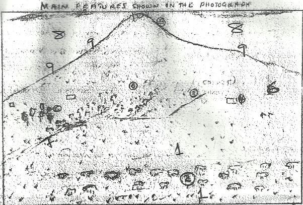
- Describe the landscape of the area represented by the photograph. (3mks)
- The land rises from the foreground towards the background.
- The area covered with vegetation is slightly raised
- The area in the background has bare rock surfaces/rock outcrops.
- The area in the foreground is greatly sloping
- Name the type of photograph shown above. (1mk)
-
- Identify two counties in the Rift Valley where ranching is practiced. (2mks)
- Kajiado
- Laikipia
- Nakuru
- Name one exotic breed of beef cattle reared in Kenya. (1mk)
- Aberdeen angus
- Hereford
- Galloway
- Charoleus
- Shorthorn
- Sahiwal
- Identify two counties in the Rift Valley where ranching is practiced. (2mks)
- State four physical factors which favour beef farming in Argentina. (4mks)
- Availability of water for cattle supplied using wind pumps.
- Warm and wet climate / maritime climate
- Gently sloping landscape
- Moderate temperature (10-24ºC)
- Fertile loose soils support growth of pasture
- Explain four benefits of beef farming to the economy of Argentina. (8mks)
- Beef is exported to earn foreign exchange to develop other sector of economy.
- Beef farming has resulted to development of roads/railways leading to increase accessibility.
- Beef farming has led to growth of towns leading to urbanization.
- Beef farming is a source of income to farmers to improve their living standard.
- Beef farming provide raw materials used in industries thus promoting industrialization.
- Study the diagram below and answer the questions that follow.
-
-
- What is agro-forestry? (2mks)
- it is the deliberate growing of trees and crops/keeping of livestocks.
- it is the deliberate growing of trees and crops/keeping of livestocks.
- Give four reasons why agro-forestry is encouraged in Kenya. (4mks)
- to ensure continous supply of wood fuel/conserve forest.
- Provide raw materials for industries
- To conserve soil
- To provide fruits/food for human consumption
- To provide fodder for animals
- Trees act as wind breakers
- What is agro-forestry? (2mks)
- Use the map of Kenya below and answer the questions that follow.
- Name the forest reserves marked H, J and K. (3mks)
- H – Mt. Elgon.
- J – Mt. Kenya
- K – Arabuk sokoke
- Explain four factors that favour the growth of natural forest in the area marked L. (8mks)
- The area receives high rainfall 1000mm- 1500mm which encourage the growth of trees
- The area has deep drained volcanic soils that allow the roots to penetrate deep into the ground
- The area has under rate to high temperature to allow for growth of a variety of type 14-26.
- Some areas are steep which discourage settlement and allows for forest growth.
- Name the forest reserves marked H, J and K. (3mks)
- Explain four problems facing forestry in Kenya. (8mks)
- Rapid increase in population has led to encroachment into forest land hence destruction of forest.
- Occurrence of forest fire which have led to the destruction of large area under forest.
- Illegal logging indiscriminate cutting of trees thereby reducing / depleting indigenous forest species.
- Attack by pest / disease has led to destruction of valuable trees species.
- At time the government alternate land under for forest to private developers.
-
-
- What is mixed farming? (2mks)
- the type of agriculture involving the growing of crops and rearing of livestock on the same piece of land/farm on rotational basis.
- the type of agriculture involving the growing of crops and rearing of livestock on the same piece of land/farm on rotational basis.
- State three economic factors influencing agriculture. (3mks)
- Operational costs of growing crops and rearing animals
- Marketing expenditure of the products to the market.
- Prize actualization of agricultural commodities.
- Government policies through subsides and guaranteed prizes to the farmers.
-
- Give four physical factors influencing coffee growing in Kenya. (4mks)
- Temperature between 14-26ºC up to 30.
- Rainfall well distributed annually 1000-2050mm
- Altitude ranges 910 – 2100 above sea level
- Red volcanic soil/medium loam soils / deep well drained soils.
- Indulating landscape / gentle slopes
- Describe coffee production in Kenya from harvesting to marketing. (8mks)
- Harvesting of coffee involves manually picking the red ripe barriers which are ripe then transported to the collecting centres where they are weighed and sorted to remove bad ones.
- They are then transported to the processing factory where they are put in large tanks having water to remove the outer covering up exposing two white beans which are then washed and sun-dried.
- The beans are sorted according to size and quality then roasted at temperature of 100OC then grounded into powder and packed ready for marketing by the coffee board of Kenya.
- Give three differences between coffee farming in Kenya and Brazil.(6mks)
- In Kenya coffee farming facing climatic problem of heavy rainfall and prolonged drought while in Brazil farmers faces the problem of frost.
- In Kenya land ownership is individual while in Brazil there is more extensive land called Fazendas suitable for coffee growing.
- In Kenya, the transportation of coffee berries from the farms to factories is mainly by road which are adequate while in Brazil transport of coffee is by well developed and adequate road and railway network from the farms to the factories.
- Give four physical factors influencing coffee growing in Kenya. (4mks)
- You intend to carry out field study of coffee growing in a farm near your school. State two disadvantages of using secondary data during data collection. (2mks)
- Easy to obtain data which has been analysed
- It is cheaper / less expensive
- Save time
- What is mixed farming? (2mks)
-
- Identify three sources of renewable energy. (3mks)
- water, wind, tides/waves, geothermal steam
- sun. biomass. Wood/trees. Drought animals
-
- Name three main hydroelectric power stations along the river Tana. (3mks)
- masinga, kamburu, gitaru, kindaruma, kiambere
- masinga, kamburu, gitaru, kindaruma, kiambere
- Apart from providing electric power, state four other benefits of the dam along the River Tana. (4mks)
- the reservoirs provide water for domestic use/industrial use/irrigation.
- The dams are tourist attraction
- The reservoirs are fresh water fisheries
- The reservoirs modify local climate
- The dams act as bridges across the river
- The dams control floods down streams
- Identify two problems that affect the production of power along river Tana. (2mks)
- Fluctuation of water levels in the reservoirs
- Inadequate capital for maintenance
- Silting of the reservoirs
- Name three main hydroelectric power stations along the river Tana. (3mks)
- Explain four measures the Government of Kenya has taken to conserve energy. (8mks)
- Encouraging people to use renewable sources in order to reduce the over reliance of fossil fuels.
- Developing energy saving technologies in order to reduce the high consumption of energy.
- Enforcing the legislation against indiscriminate cutting down of trees for fuel thus conserving existing resources.
- Educating the public on the careful use of energy in order to save it.
- Progress taxation on energy consumption in order to discourage the misuse of energy.
- Encouraging the use of public transport in order to reduce the number of vehicle on the road thus reducing energy consumption.
- Discouraging importation of high fuel consumption vehicle to reduce amount of fuel used.
- Encouraging afforestation/reafforestion for continous supply of wood fuel.
- Some students carried out field study on sources of energy by sampling the households around the school.
- Identify two sampling technique the students may have used during the study. (2mks)
- Stratified sampling
- Clustered sampling
- Give three advantages of sampling the households for the study. (3mks)
- Saves time for the study
- It costs less
- High data accuracy
- Identify two sampling technique the students may have used during the study. (2mks)
- Identify three sources of renewable energy. (3mks)
-
- Differentiate between a rural settlement and an urban centre. (2mks)
- A rural settlement consists of villages/ scattered homesteads in the countryside where people engage mainly in agricultural activities / primary economic activities while urban centre is an area with dense population and people engaged mainly in industrial/commercial activities.
- A rural settlement consists of villages/ scattered homesteads in the countryside where people engage mainly in agricultural activities / primary economic activities while urban centre is an area with dense population and people engaged mainly in industrial/commercial activities.
- Explain how the following physical factors influence human settlement.
- Relief (6mks)
- Flat areas/flood plains are sparsely settled due to poor drainage /high incidents of water borne diseases.
- Gentle slopes / low lands are densely settled because they are conducive to agricultural /building houses /building roads.
- Steep slopes are sparsely settled because they have thin soils making them unsuitable for farming /building roads.
- High mountains tops are not settled because they are too cold for plant growth/human habitation.
- Mountains areas are thinly settled because of their steep/rugged nature makes them inaccessible.
- The leeward sides of mountains are sparsely settled because they are dry and limits agricultural activities / inadequate water supply.
- Windward sides are densely settled because they are wet and encourage agricultural activities / plenty supple of water.
- Some hills have dense settlement because they are safe and secure.
- Climate (4mks)
- Areas that receives high rainfall have dense settlements because they are conducive to a variety of agricultural activities.
- Areas with low rainfall are sparsely settled because the climate limits economic activities.
- Areas prone to strong wind are often not settled to avoid destruction of property by wind.
- Some valley bottoms have more settlements because they are warmer than the high slopes of mountain.
- Area with high / extreme temperature discourages settlement because of the unpleasant condition.
- Low/high temperature/cool to hot conditions encourage dense settlements because they are conducive to human habitation.
- Relief (6mks)
- Explain the causes of the following problems in urban centres in Kenya.
- Traffic congestion (4mks)
- The construction of administrative / commercial / educational function in the CBD lead to movement of large numbers of people to and from CBD especially during the rush hours.
- The narrowness of the streets makes the movement of traffic around and out of the urban centre slow.
- The increase of number of commuters/vehicles that flock in the morning and evenings has outstrip ped the capacity of the exisiting space.
- Similar working schedules for most employees cause workers to report and leave work spaces at the same time leading to congestion.
- Failure by motorists / pedestrians to comply to traffic rules interfere with smooth flow of traffic.
- Environmental degradation (4mks)
- The smoke / exhaust fumes from factories /cars/residential houses causes air pollution over the urban centres.
- Careless disposal of effluents from factories/residential areas into water resources leads to water pollution.
- Careless disposal /non – collection of garbage cause land pollution
- The construction of buildings / factories lead to destruction of the landscape.
- Careless disposal of waste materials from construction sites leads to tip – heaps that degrade the environment.
- Traffic congestion (4mks)
-
- Name two towns in Kenya that started as agricultural collection centres . (2mks)
- Nakuru
- Eldoret
- Nanyuki
- Kitale
- Nyahururu
- Give three social functions of Kisumu town. (3mks)
- Education centre
- Religious centre
- Residential centre
- Cultural centre
- Recreational centre
- Medical centre
- Name two towns in Kenya that started as agricultural collection centres . (2mks)
- Differentiate between a rural settlement and an urban centre. (2mks)
Join our whatsapp group for latest updates
Tap Here to Download for 50/-
Get on WhatsApp for 50/-
Download Geography Paper 2 Questions and Answers - Form 4 End Term 1 Exams 2021.
Tap Here to Download for 50/-
Get on WhatsApp for 50/-
Why download?
- ✔ To read offline at any time.
- ✔ To Print at your convenience
- ✔ Share Easily with Friends / Students


