
QUESTIONS
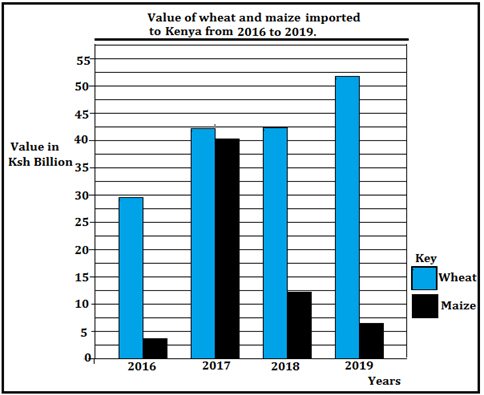
- Study the graph below and use it to answer the question (a) and (b).
-
- Identify the type of graph drawn above. (1 mark)
- Give the trend of the imports represented on the graph (2 marks)
- State three problems facing maize farmers in Kenya. (3 marks)
-
-
- Name two fishing nations within the North East Pacific fishing ground. (2 marks)
- Give three measures taken to address the problem of overfishing in Kenya. (3 marks)
- State three disadvantages of petroleum as a source of energy. (3 marks)
-
- Distinguish between balance of trade and balance of payments. (2 marks)
- State three objectives of forming Common Market for Eastern and Southern Africa. (COMESA) (3 marks)
-
- Give three natural environmental hazards. (3 marks)
- State three causes of water pollution in Kenya. (3 marks)
-
-
- Apart from a census, give two other primary sources of population data (2 marks)
- State three reasons why a census is important to Kenya (3 marks)
- Explain three causes of a reduced fertility rate in Kenya (6 marks)
-
-
- Define the term urbanization. (2 marks)
- The diagram below shows the functional zones of an ideal urban centre.
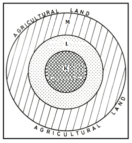
- Identify the zones marked L and M. (2 marks)
- Sate four characteristics of the zone marked K. (4 marks)
- Explain how Lake Victoria has contributed to the growth of Kisumu. (6 marks)

MARKING SCHEME
-
-
- Comparative bar graph.
-
- The value of wheat imports had been increasing over the four years.
- Value of maize imports increased sharply in 2017 then declined in the following years.
- Year 2019 had the highest value of wheat imports.
- The difference in value of wheat and maize imports was smallest in year 2017.
- 2016 had the lowest value of maize imports.
-
- The crop is attacked by pests i.e. weevils/birds/aphids/army worms/stalk-borer lowering yields and quality
- The crop is attacked by diseases such as maize lethal Necrosis and white leaf blight thus lowering yields and quality.
- The crop is affected by fluctuations in market prices, reducing income to the farmer.
- Some maize growing areas have poor /impassable roads, during the rainy seasons which affect the production/delivery of the harvest.
- Inadequate rainfall/drought at times leads to crop failure.
- High cost of farm inputs prices which reduce farmers’ income.
- Delayed payments to farmers reduce their morale.
- Poor storage facilities /silos thus the produce is destroyed by the weevils.
-
-
- Canada
United States of America. -
- Fishing is restricted to specific seasons to allow for breeding and maturing of fish
- Enforcing the use of standardized nets to prevent catching of immature fish/fingerlings
- Licensing fishermen to control their number and to ensure that there is no over-fishing.
- Patrolling the Kenyan waters at the coast to prevent foreign fishing vessels.
- Fish farming is being encouraged to that there is sufficient supply of fish from other sources other than the natural fisheries
- Restocking of over-fished waters by introducing fingerlings from hatcheries.
- Canada
-
- Crude oil is bulky to transport.
- Burning petroleum products pollutes the environment.
- Petroleum products are highly inflammable thus deadly if improperly handled.
- Oil exploration is very expensive.
- Petroleum is an exhaustible source of energy.
-
- Balance of trade is the difference in value between a country’s visible exports and its visible imports whereas balance of payments is the difference in value between a country’s total exports (visible and invisible) and its total imports (visible and invisible).
-
- To create a common market for goods produced within member states.
- To promote transport and communication between member states.
- To reduce unnecessary competition amongst member states.
- To eliminate taxes on goods produced within member states.
- To establish a common bank that would assist in investment, economic and social development.
- To enable the member states to increase the use of their raw materials.
- To facilitate good relations, peace, political stability and high standards of living
-
-
- Volcanic eruptions
- Windstorms
- Earthquakes
- Pests and diseases
- Lightning
- Floods
- Land slides
-
- Discharge of toxic industrial effluent in water bodies.
- Poisonous farm /agrochemicals that are drained into rivers through surface runoff.
- Animal waste from abattoirs and farm houses which are discharged in water bodies.
- Soil erosion due to human activities which pollutes rivers and lakes.
- Rotting garbage which is washed into rivers thus polluting the water.
- Discharge of raw sewage into water bodies such as rivers, lakes and the sea.
- Oil spills from oil rigs, tankers, water vessels and underwater pipelines.
-
-
-
- Sample surveys
Registration of persons -
- A census provides information on the trends of mortality and fertility
- Information obtained helps governments to plan for the provision of basic facilities such as schools hospitals and food
- It helps in the creation of new administrative units such as counties, constituencies or wards
- It shows the composition of population in terms of age sex and regional distribution
- Total population assists the government to know if there are adequate resources
- A population census enables the estimation of population growth to determine literacy level.
- Sample surveys
-
- Increased rate of use of birth control measures among many productive females which lowers the number of children.
- More girls are attending school up to tertiary levels thus delaying in getting married which contributes to a lower fertility rate.
- Increased number of women mainly in urban centres opting to remain single thus opting to have very few children
- Modern career opportunities may delay young women from getting children as some employers avoid women who keep on going on maternity leave.
- Hard economic times in urban centres and the high cost of child upkeep have forced many people to limit the number of children which lowers the fertility rate.
-
-
- Urbanization is the process through which people are transformed from the traditional agricultural lifestyle to a modern commercial lifestyle.
-
- L – Industrial zone/area
M – Residential zone/area -
- Has many tall buildings / sky crappers.
- Has very high land/rental value.
- Has very limited space.
- Has vertical extension of buildings to maximize on land use
- It is the centre of traffic focus.
- Has limited surface parking space.
- Has traffic jams during rush hours.
- Underground parking space is common.
- Traffic flow is constant and slow
- Has high population density during the day and low at night.
- L – Industrial zone/area
-
- Being a lake port, Kisumu handles goods across the Lake Victoria to neighbouring countries such as Uganda and Tanzania thus facilitating regional trade.
- Kisumu’s location on the shores of Lake Victoria ensures a reliable source of water for domestic and industrial use.
- Fishing activities in Lake Victoria and the establishment of fish processing industries has attracted many people contributing to the growth of the Lakeside City.
- Lake Victoria attracts many tourists who visit Kisumu thus increased income to the local residents.
Join our whatsapp group for latest updates
Tap Here to Download for 50/-
Get on WhatsApp for 50/-
Download Geography Questions and Answers - Form 4 Mid Term 2 2022.
Tap Here to Download for 50/-
Get on WhatsApp for 50/-
Why download?
- ✔ To read offline at any time.
- ✔ To Print at your convenience
- ✔ Share Easily with Friends / Students


