GEOGRAPHY PAPER 1 - 2019 LAINAKU JOINT MOCK EVALUATION EXAMINATION
Get the complete GEOGRAPHY PAPER 1 - 2019 LAINAKU JOINT MOCK EVALUATION EXAMINATION PDF on WhatsApp by tapping on the button
SECTION A
Answer all the questions in this section.
-
- Differentiate between latitudes and longitudes. (2 mks)
- State three reasons why the interior of the earth is very hot. (3 mks)
- Describe the origin of the continents according to the theory of continental drift . (5mks)
-
- Name the three main stages of the long profile of a river(3mks)
- State three conditions under which gorges may form(3mks)
-
- Give two sources of underground water. (2mks)
- State three conditions that favour the formation of artesian wells. (3mks)
-
- What is the meaning of the term vegetation? (1 mk)
- Use the sketch map below to answer the questions that follow
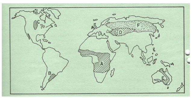
- Identify the type of vegetation in the shaded region marked F (1 mk)
- State two characteristics of theabove identified vegetation type ( 2mks)
SECTION B
Answer question six and any other two questions from this section
Study the map provided of Taita Hills 1:50000(Sheet 189/14) and answer the questions that follow.
-
-
- Convert the scale of the map into a statement scale. ( 1mk )
- Give the six grid figure reference of the dispensary at Ronge forest.( 2mks)
- Calculate the area of Ronge forest. Give your answer in KM2( 2mks)
-
- What is the actual height of the hill at grid square 3926. (1 mk)
- Describe the distribution of settlement in the area covered by the map. ( 4mks)
- Draw a cross section from grid reference 360160 to grid reference 440160. Use a vertical
scale of 1cm to represent 20m. ( 4mks)
On the cross-section,mark and name the following;- A railway line. (1mk)
- Thicket vegetation(1mk)
- A hill (1mk)
- Students of Weruga School (grid square 2524) carried out a field study on vegetation west of their school.
- Give three reasons why they would require a time schedule. (3 mks)
- Name twonatural vegetation that they identified. (2 mks)
- Citing evidence from the map name three social services that are carried out in the area coveredby the map.(3mks)
-
-
- What is ocean salinity? (2mks)
- Give three sources of mineral salts in ocean water. (3mks)
- Explain three factors that cause horizontal movement of ocean water. (6mks)
- Describe how the following are formed
- Wave-cut platform. (4mks)
- Cuspate foreland. (5mks)
- You intend to carry out a field study on wave deposition on the coast of Kenya.
- Formulate two hypotheses for your study. (2mks)
- Give three reasons why you would need to state objectives for your study.(3mks)
-
-
- Listfour characteristics of desert soils. (4 mks)
- Give two factors that contribute to soil leaching. (2 mks)
- Explain how each of the following factors influence the formation of soil
- Parent rock (2 mks)
- Living organisms (2 mks)
- Topography (2 mks)
- Draw a well labelled profile of a mature soil. (5 mks)
- Differentiate between a soil profile and soil catena. (2 mks)
- Explain three ways in which human activities contribute to soil erosion. (6 mks)
-
-
- What is a glacier?(2mks)
- How is a glacier formed? (4mks)
- Explain three processes through which ice moves (6mks)
- Describe the formation of a cirque (3mks)
- Describe how the movement of valley glaciers is influenced by the following factors
- Temperature (2marks)
- Width of glacier channel (2marks)
- You intend to carry out a field study on Mt Kenya
- Name three types of moraines you are likely to identify (3mks)
- State three problems you are likely to encounter (3mks)
-
-
- Define the following features
Erg (1 mk)
Hamada (1 mk)
Reg(1 mk) - State two factors that contribute to the development of hot desert. (2 mks)
- Define the following features
- With the aid of well labeled diagrams explain how a rock pedestal is formed.( 8mks)
- Explain three factors that influence wind transportation in a desert. (6 mks)
- You are required to carry out a field study of an arid area in Kenya.
- Formulate two objectives for the study findings. (2mks)
- State two measures the government would put in place to curb desertification in Kenya. (2mks)
- Name any two features resulting from action of water in desert areas.( 2mks)
-
MARKING SCHEME
-
- Differentiates between latitudes and longitudes
– Latitudes run from west to east while longitude run from north to south
– Latitudes show how far a place is from the equator while longitude show how far
– Latitudes are parallel to one anotherwhile longitudes meet at the poles
– Distance between latitudes is even around the globe while that between longitudes is longest at equator and decreases pole wards2 marks-Mark as a bloc - State three reasons why the interior of the earth is very hot
– The rate of cooling was very slow thereforeinterior still retain much of the original heat
– The overlying rock layer exert a lot of pressure generating heat
– Radioactivity within the interior due to collision results in heat generation 3 x 1 = marks
- Differentiates between latitudes and longitudes
- Describing the theory of continental drift.
-Originaly the earth was a large huge land mass called pangaea
- Pangaea was surrounded by large water mass/ocean/panthalasa
- Pangaea broke into two subcontinents ienorthren continent (laurasia) and southern continent (gondwanaland)
-The two continents were separated by a narow sea/ tethys
-The two continents broke further
-Laurasia split to form continents in the northern hemisphere
-Godwanaland split to form continents in the southern hemisphere
-The continents gradually drifted to their present position
Key words must be mentioned to score Max. 5mks
-
- What are the three stages of the long profile of a river?
- Youthful stage /young stage/torrent stage / upper course stage
- Mature stage /middle stage/valley stage
- Old stage/plain stage/lower course stage
( 3 x 1 = 3 mks) - State three conditions under which gorges may form
- Where a waterfall retreats upstream forming a gorge downstream side of waterfalls.
- Where a river flows across a plateau made up of alternating horizontal layers of hard and soft rocks.
- Where a river maintains its flow on the land that is being uplifted
- Where there is a fall in the sea level /base level making a river to renew its erosive activity.-Where a river flows along a line of weakness like a fault line with less resistant rocks.
(Any 3 x 1 = 3mks
- What are the three stages of the long profile of a river?
-
- Give two sources of underground water
– Rainwater
– Melt water
– Lakes and sea water
– Magmatic water
– Rivers (2 x1 =2 marks) - Condition that favour the formation of artesian well
– The aquifer must be sandwiched between impermeable rocks so that it can retain water.
– The aquifer must outcrop in a region which is source of water e.g a rainy area.
– The aquifer must dip from a region of water intake and the rock layers must form a broad syncline basin
– The mouth of the well must be lower than the intake area to allow water to be forced to the surface by pressure Any 3 x1 = 3 marks)
- Give two sources of underground water
-
- What is vegetation
Is a community of plants and grasses that cover a place and give a distinct character.
1* 1=1 mark - Name the vegetation marked F
Coniferous forest 1*1=1 mark - Characteristics of identified vegetation type.
-Trees are conical in shape
Trees have needle like shaped leaves
-Trees are in uniform stands
-Consists of a thick carpet of mosses on its undergrowth.
-Trees are evergreen.
-Trees are tall and have straight trunks
-Trees have thick backs Any 2*1=2marks
- Name the vegetation marked F
- What is vegetation
SECTION B
- Study the map provided of Taita Hills and answer the question that follow.
-
- convert the scale of the map into a statement scale. (1 mrk)
1 cm rep 0.5km/one centimeter represents half km. (Show working) - Give the six-grid figure reference of the Dispensary at Ronge forest.
367297(2 mks) - Calculate the area of Ronge forest.
- Complete squares -0
-Incomplete 8/2
- Area 4km2+/- 0.5 km2( 2 mks)
(Must show working)
- convert the scale of the map into a statement scale. (1 mrk)
-
- What is the actual height of the hill at grid reference 3926?
873m 1 x 1 = mark - Description of distribution of settlement
–The western part of the area covered by the map has denser settlement
-Some places have nucleated settlement-Mwatunge
-Eastern part has sparse settlement
There is linear settlement along transport lines eg roads
Thicket/ forest areas have little or no settlements
Steep areas have little or no settlements e.gMragua Hills
(Any four 4x1 = 4 mks )
- What is the actual height of the hill at grid reference 3926?
-
- Give three reasons why they would need a time schedule
− To give ample time for each activity
− To reduce the tendency of time wastage
− To provide an estimate of time requirement for the study
− To provide a basis or evaluation the field work while still in progress
− To provide a framework guiding the researcher to remain within the topic is scope
(Any 3 x1)=3mks - Name two natural vegetation that they identified
- woodland
- scrub
- scattered traces 2 x 1 = 2 marks
- Give three reasons why they would need a time schedule
- Citing evidence from the map name three social services that are found in the area covered by the map
- Rehabilitation-prison /Rehabilitation centre
- Education – schools
- Religious/worship – churches /
- Health – Dispensary /Health Centre (Any 3 x 1 = 3mks
-
-
- What is ocean salinity?
-The degree of saltiness in ocean water (2 marks) - Give three sources of mineral salts in ocean water
- Underlying rocks on sea floor which dissolves in the ocean water
- Magma from mantle outpouring on the sea floor during vulcanicity and minerals dissolve in ocean water
- Rivers pouring their water into the ocean have dissolved minerals `
(Any 3 x 1 =3 marks)
- What is ocean salinity?
- Explain three factors that causes horizontal movement of ocean waters.
- Winds moving across an ocean cause a frictional drag on the ocean water making the water to move in the same direction as wind
- Rotation of the earth leads tocoriolis force which deflect ocean water to their right in the northern hemisphere.
- Presence of land masses in the ocean makes already moving ocean water to split hence forming new stream of movement.
- Differences in the temperature of ocean water make ocean water to move from low temperature areas towards the high temperature areas
- Differences in water density make the ocean water flow from high density areas towards low density areas (Any 3 x 2 =6 marks) - Describe how the following are formed
- wave- cut platform
- Marine wave erosion takes place on the shore line
- A small hollow called a notch develops
- Repeated wave erosion enlarges the notch until it collapses
- Another notch soon begins to develop on the new cliff face and collapses again
- The sea level falls leaving behind a wide gently sloping pavement called wave cut platform
(Well explained =4marks) - Cuspate foreland
- Long shore drift operating along a coast brings materials such as sand and shingle to the shore
- The material gets deposited from the shore seawards forming to adjacent spits
- Due to continued deposition of sand by long shore drift the splits extend towards each other
- With time the two spits join to form a triangular shaped deposit of sand enclosing a lagoon in the sea called a cuspate foreland (Well explained= 4 marks)
- wave- cut platform
-
- Formulate two hypotheses for your study
-Most of the features found on the coast were not formed as a result of wave deposition
- There is no relationship between the slope of the land and wave deposition features.
-Wave deposition features on Kenyan coast have no much economic importance
(Any 2 well stated 2 x 1 =2 marks) - Give three reasons why you had to state objectives for your study
- To keep the scope of your study
- To determine the tools/equipment for use during data collection
- Enable gauge the success of the study
(Any3 x 1 =3 marks)
- Formulate two hypotheses for your study
-
- Characteristics of desert soils
- They are thin / shallow
- They are stoney / sandy
- They are saline
-They are loose in texture
-Low moisture contents
- Rich in calcium (Any 2 x1 =2 marks) - Two factors that influence soil leaching.
- Nature of the soil/ solubility of the minerals .
-High rainfall.
- Topography (Any 2 x1 =2 marks )
- Characteristics of desert soils
- Explain how each of the following factors influence the formationof soil
- Parents rock.
- The nature of rock influence weathering .hard rocks weather slowly while soft rocks weather fast
- The rock determines the soil texture
-The type of minerals in the parents rock are transferred to the soil during formation
(Any 2x1=2mks - Living organisms
-They assists in breaking down the rocks through burrowing ,ploughing root penetration.
- They influences the chemical composition by adding / removing organic acid solution / minerals -Burrowing / digging influence soil aeration
(Any 2x1=2mks) - Topography.
-It determines the rate of weathering/ steep slopes encourage rapid weathering.
-It influences soil depth, gentle slopes have deep soils.
-It influences soil drainage / where land is flat soils are poorly drained
(Any 2x1=2mks)
- Parents rock.
- A well labelled profile of mature soil
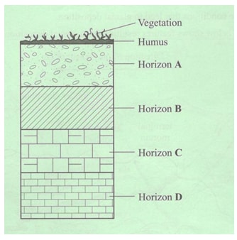
- Differentiate between a soil profile and catena.
- soil profile is the vertical arrangement of soil layers into horizon while catena is the sequential soil arrangement along a slope Mark as a bloc (2 x1 =2 marks ) - How human activities contributes to soil erosion.
-Monoculture exhaust soil making soil vulnerable to erosion.
- Over stocking reduces vegetation cover.
- Ploughing up and down a slope.
-Deforestation.
- Mining & quarrying.
- Shifting cultivation
(Any 3 well explained points x 2= 6mks)
-
- What is a Glacier
– a mass of ice which moves outwards from a central area of ice accumulation under gravity (2 mks) - Formation of a glacier
- Snow fall occurs – snow accumulate in preexisting valleys and depressions on the earth surface
- Continental snowfall increases the weight of snow compressing it and resulting in Thawing of some underlying ice.
- With time becomes thick, hard and glossy because all air has been squeezed out of it and it moves because the lower layers are plastic due its weight. (Well explained) 4 mks
- What is a Glacier
-
- Process of ice movement
-Plastic flowage- as viscous mass due to the weight of the overlying layer of ice
-Basal slip – the weight of the ice causes thawing of the lower layers creating a film of melt water. Gravity the cause ice to slip as slide over the underlying rock.
- Internal shearing – differential sliding of ice along places due to the great down shape pressure
(Process 3 mks)
(Explanation 3 mks) - Describe the formation of a cirque (3mks)
- Pre existing depression on the mountain side snow accumulate in the depression and form a cirque glacier
- Frost action by the cirque glacier enlarges the hollow.
- Abrasion at the bottom deepen the depression.
- Plucking process steepenes the sides and back
Eventually a depression resembling an arm chair with a concave floor is formed.
(Any 3 x1=3 mks
- Process of ice movement
-
- temparature-
-Glaciers move faster in summer/when the temperatures are higher because the ice melts due to the warm conditions, whereas in winter/when temperatures are low, ice movement is slow due to cold conditions.
-The temperature of the bottom of the valley glacier rises with increased pressure thereby thawing and enabling its movement down slope. (2 marks) - Width of the glaciers channel
-When the channel is wide, ice movement is slow, that is, because ice spreads out forming a thin layer, hence there is less pressure to cause thawing that would facilitate ice movement/when the channel is narrow. (2 marks)
- temparature-
- You intend to carry out a field study on Mt Kenya
- Name three types of moraines you are likely to identify
-Terminal moraine
-Lateral moraine
-Ground moraine
- Media /moraine
Any 3x1=3mks - State three problems you are likely to encounter
- Fatigue due to climbing / descending steep slope
- cold weather
- Wild animals
- Thick vegetation / inaccessibility
Any 3x1= 3mks
- Name three types of moraines you are likely to identify
-
-
- Define the following feature
- Erg – sandy desert 1 mk
- Hamada – rocky desert 1 mk
- Reg – stony desert 1 mk - State two factors that contribute to the development of hot desert.
− Increased temperature and excessive evaporations
− Low rainfall / drought
− Rain shadow effect
− Continentally
− Existence of cold ocean currents
− Human activities e.g. detours Any2 x1=2 mks
- Define the following feature
- With the aid of well labeled diagrams explain how a rock pedestal is formed.
− Rocks of heterogeneous nature are acted on by wind abrasion and weathering process
− The softer rocks are eroded faster than the hard rocks
- Abrasion is more pronounced near the ground surface because the materials are heavier
-This results into the formation of a rock structure with alternating layers of grooves and protrusionscalled a rock pedestal - Explain three factors that influence wind transportation in a desert.
− Speed and force of the wind - the faster and more forceful the wind is the greater the load it can transport
− Nature of the load - fine dust are easily picked up and blown away while heavy ones are dragged − All interfering obstacle in the pathway
− State of the particles moisture content of the material
(Any 3 x 2 = 6mks) - You are required to carry out a field study of an arid area in Kenya.
- Formulate two objectives for the study findings. (2mks)
− To find out the different features formed as a result of wind action
− To identify the most common agent of erosion in the area
Any 2 x 1 = 2mks
Any other relevant objective - State two measures the government would put in place to curb desertification in Kenya.
− A forestation & re afforestation
− Controlled grazing − Irrigating dry lands
− Stabilizing sand dunes
− Controlling soil erosion and adopting conserving measures
− Controlling industrialization
(Any 2 x 1 = 2 mks - Name any two features resulting from action of water in desert areas.
− Bajada
− Inselberg
− Mesas and buttes
− Pediments
− Pedi plain
− Playas
− Salinas
− Dry river valley
(Any 2x 1 = 2 mks)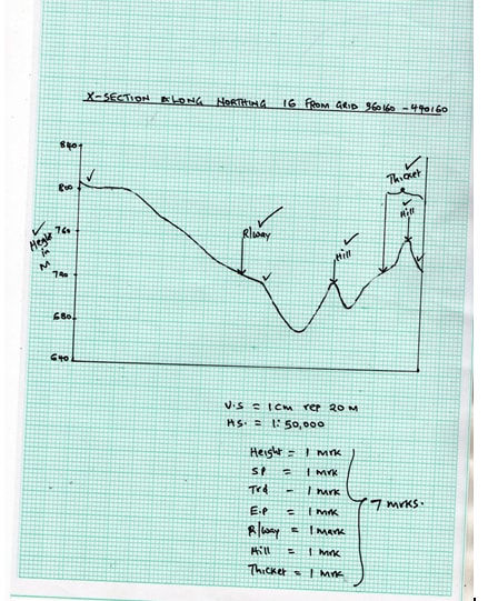
- Formulate two objectives for the study findings. (2mks)
-