Geography Paper 2 Questions and Answers - Moi Tea Mock Examinations 2022
Get the complete Geography Paper 2 Questions and Answers - Moi Tea Mock Examinations 2022 PDF on WhatsApp by tapping on the button
Questions
INSTRUCTIONS TO CANDIDATES
- This paper has two sections: A and B
- Answer ALL the questions in section A.
- In section B, answer questions 6 and any other TWO questions.
- All the answers must be written on the foolscaps provided after page 4.
- Candidates must answer the questions in English.
SECTION A
-
- What is management of forests? (2 marks)
- State three reasons why agroforestry is encouraged in Kenya. (3 marks)
-
- Name two categories of agricultural processing industries in Kenya. (2 marks)
- State three similarities between the cottage industry of India and the Jua Kali industry in Kenya. (3 marks)
-
- Differentiate between settlement and urbanization. (2 marks)
- State four characteristics of central business district of a town. (4 marks)
-
- Name two types of environment. (2 marks)
- State three consequences of water pollution. (3 marks)
- The map below shows the Great Lakes and St. Lawrence Seaway. Use it to answer question (a) and (b).
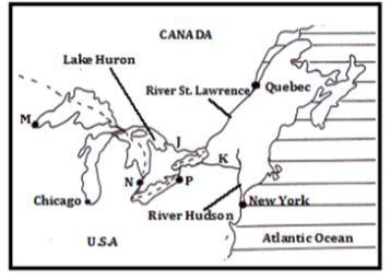
- Name the canals marked J and K. (2 marks)
- Name the towns marked M and N. (2 marks)
SECTION B
- Study the table below and use it to answer questions (a) and (b)
Value of leading imports to Kenya from 2015 to 2019 (Ksh million)
IMPORT 2016 2017 2018 2019 Industrial machinery 253 500 238 400 252 400 257 600 Petroleum products 183 800 234 900 295 100 307 500 Iron and Steel 75 500 83 600 97 700 104 100 -
- What is the difference between the value of petroleum products imports between year 2018 and year 2016? (2 marks)
- Calculate the percentage increase between the value of industrial machinery imported between year 2017 and the year 2019. (2 marks)
-
- Apart from comparative bar graphs, give three other statistical methods that can be used to present the data in the table. (3 marks)
- Using a vertical scale of 1cm to represent Ksh 30 Billion, draw a comparative bar graph to present the data in the table. Use the graph paper provided. (9 marks)
- State three advantages of using comparative bar graphs to present statistical data. (3 marks)
- Explain three reasons for low volume of trade between the countries in Africa. (6 marks)
-
-
-
- Define the term mining? (2 marks)
- Give four methods of underground mining. (4 marks)
- Explain how the following factors influence mining:
- Level of technology (4 marks)
- Quality of the ore (2 marks)
- Explain four benefits of trona mining at Lake Magadi to Kenya. (8 marks)
- State five negative effects of mining on the environment. (5 marks)
-
-
-
- State three physical factors that favour tea growing in Kericho County. (3 marks
- Describe the stages involved in tea processing at the factory. (7 marks)
- Outline three ways in which tea is marketed in Kenya. (3 marks)
- Explain three physical problems facing small scale tea farmers in Kenya. (6 marks)
- Your Geography class carried out a field study on a tea plantation.
- Give three reasons why it is important to prepare a route map of the area. (3 marks)
- State three methods that the class would have used to present data. (3 marks)
-
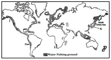
- The map below shows the major fishing grounds of the world. Use it to answer question (a) (i), (ii) and (iii)
-
- Name the fishing ground marked J,K,L and M (4 marks)
- Name the two ocean currents that converge at region M (2 marks)
- Explain three physical factors that have favoured fishing in country N. (6 marks)
-
- Describe how trawling as a method of fishing is carried out. (5 marks)
- Explain four measures being undertaken in Kenya to reduce overfishing of the natural water fisheries (8 marks)
-
-
-
- Name three non-renewable sources of energy. (3 marks)
- State four advantages of solar energy. (4 marks)
- The diagram below shows the Kenya’s hydroelectric power stations along River Tana.
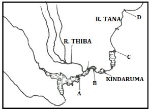
- Name the H.E.P stations marked A, B and C. (3 marks)
- The proposed H.E.P dam site marked D. (1 mark)
- Explain four challenges hindering hydroelectric power generation in Kenya (8 marks)
-
- What is an energy crisis. (2 marks)
- Explain the effects of an energy crisis in the following sectors.
- Agriculture (2 marks)
- Industries (2 marks)
-
Marking Scheme
-
- What is management of forests? (2 marks)
- Management of forests is the effective planning and control/careful use of forest resources to ensure their sustainability.
- State three reasons why agroforestry is encouraged in Kenya. (3 marks)
- Planted trees help in soil conservation/control soil erosion
- Some fruit trees provide farmers with fruits for consumption or for sale.
- Some planted trees are sold at maturity for timber thus generating income to farmers.
- Some planted softwood trees provide raw materials to some industries.
- Planted trees ensure continuous supply of wood fuel thus conserving forests.
- Some trees provide fodder for animals/livestock kept by farmers.
- What is management of forests? (2 marks)
-
- Name two categories of agricultural processing industries in Kenya. (2 marks)
- Agricultural food processing.
- Agricultural non-food processing.
- State three similarities between the cottage industry of India and the Jua Kali industry in Kenya. (3 marks)
- Both use locally available raw materials.
- Both rely heavily on local market.
- Both use simple tools/technology.
- Both are mainly located in urban centres.
- Both require small capital investment.
- Both rely on individual owners and family members for labour.
- Name two categories of agricultural processing industries in Kenya. (2 marks)
-
- Differentiate between settlement and urbanization. (2 marks)
- A settlement is a place with housing units or buildings where people live as they engage in various economic activities while Urbanization is the process through which people are transformed from the traditional agricultural life style to a modern commercial lifestyle.
- State four characteristics of central business district of a town. (4 marks)
- Has many tall buildings / sky crappers
- Has very high rental value
- Has very limited space
- Has vertical extension of buildings to maximize on land use
- It is the centre of traffic focus
- Has limited surface parking space
- Has traffic jams during rush hours
- Underground parking space is common
- Traffic flow is constant and slow
- Has high population density during the day and low at night.
- Differentiate between settlement and urbanization. (2 marks)
-
- Name two types of environment. (2 marks)
- Physical environment
- Human environment
- State three consequences of water pollution. (3 marks)
- Death of aquatic organisms such as fish.
- Spread of waterborne diseases such as typhoid and cholera.
- Growth of some water weeds that cover parts of water bodies.
- Some diseases may affect people who consume contaminated fish/crustaceans.
- Contamination of quality water for domestic and industrial use.
- Name two types of environment. (2 marks)
- The map below shows the Great Lakes and St. Lawrence Seaway. Use it to answer question (a) and (b).
- Name the canals marked J and K. (2 marks)
- J – Trent Canal
- K – New York State Barge Canal
- Name the towns marked M and N. (2 marks)
- M – Port DuluthN – Detroit
- Name the canals marked J and K. (2 marks)
- Study the table below and use it to answer questions (a) and (b)
IMPORT 2016 2017 2018 2019 Industrial machinery 253 500 238 400 252 400 257 600 Petroleum products 183 800 234 900 295 100 307 500 Iron and Steel 75 500 83600 97 700 104 100
Value of leading imports to Kenya from 2015 to 2019 (Ksh million)-
- What is the difference between the value of petroleum products imports between year 2018 and year 2016? (2 marks)
- Ksh 295,000 million – Ksh 183,000 million = Ksh 111,300 million
OR Ksh 111,300,000,000
OR Ksh 111.3 Billion
- Ksh 295,000 million – Ksh 183,000 million = Ksh 111,300 million
- Calculate the percentage increase between the value of industrial machinery imported between year 2017 and the year 2019. (2 marks)
- Difference Ksh 257,600 million – Ksh 238,400 million = Ksh 19,200 million
Ksh 19,200 million X 100% = 8.05%
Ksh 238,400 million
- Difference Ksh 257,600 million – Ksh 238,400 million = Ksh 19,200 million
- What is the difference between the value of petroleum products imports between year 2018 and year 2016? (2 marks)
-
- Apart from comparative bar graphs, give three other statistical methods that can be used to present the data in the table. (3 marks)
- Comparative line graphs.
- Compound /cumulative bar graph
- Proportional circles
- Proportional divided circles
- Using a vertical scale of 1cm to represent Ksh 30 Billion, draw a comparative bar graph to present the data in the table. Use the graph paper provided. (9 marks)
- Apart from comparative bar graphs, give three other statistical methods that can be used to present the data in the table. (3 marks)
- State three advantages of using comparative bar graphs to present statistical data. (3 marks)
- Are easy to construct
- Are easy to read
- Gives a clear visual impression
- Allows for easy comparison.
- The bars emphasize quantities very well.
- Explain three reasons for low volume of trade between the countries in Africa. (6 marks)
- Political instability in some countries due to civil wars discourage trade with neighbouring countries
- Most countries produce similar goods mainly agricultural or minerals thus low demand for trade goods..
- Poor transport and communication links hinder movement of goods using roads and railways..
- The flow of trade still follows colonial patterns where most African countries still have strong ties with their colonial masters..
- Industrialized countries have better trade partners as they provide essential manufactured goods while African countries produce mainly agricultural produce.
- Different political ideologies discourage trade.
-
-
-
- Define the term mining? (2 marks)
- Mining refers to the process of extracting valuable minerals and fossils fuels on or from the earth’s crust.
- Give four methods of underground mining. (4 marks)
- Deep shaft
- Drilling
- Adit/drift
- Solution
- Define the term mining? (2 marks)
- Explain how the following factors influence mining:
- Level of technology (4 marks)
- Advanced technology has improved mining operations thus leading to high quality /large quantity mineral products.
- High level technology allows for effective exploration of minerals leading to accurate location of minerals.
- Advanced technology boost effectiveness in production hence reducing wastage.
- Quality of the ore (2 marks)
- High grade ores yield more metal thus very economical to mine while low grade ores yield low metal.
- Crude oil with very light and with the least Sulphur is the best quality thus highly preferred than heavy crude with more Sulphur.
- Level of technology (4 marks)
- Explain four benefits of trona mining at Lake Magadi to Kenya. (8 marks)
- Export of soda ash earns foreign exchange to Kenya which is used in foreign trade.
- Trona mining has created employment opportunities to many Kenyans who earn income thus improving their standards of living.
- Development of glass and bottle industry as soda ash provides the main raw material.
- Trona mining has led to development of a tarmac road and railway branch from Konza to Magadi.
- Provision of social amenities such as schools and a hospital thus improving living standards of the local people.
- The Kenyan government (national and county) earns revenue through taxation on the profit of the company.
- The company provides free water to the local people for both domestic and livestock use.
- Trona mining has led emergence and growth of Magadi town
- State five negative effects of mining on the environment. (5 marks)
- The land is left bare with large craters which are ugly/ loss of the beauty of land.
- Heaps of rock waste hinders any other form of land use.
- Clearance of land before exploitation of minerals encourages soil erosion.
- Clearing natural vegetation in an area for mining leads to loss of plant and animal life/loss of biodiversity.
- Open cast mining leads to shortage of land due to displacement of people and land dereliction.
- Dust produced during open cast mining pollutes the atmosphere.
- Large scale blasting of rocks causes instability of basement rocks.
-
-
-
- State three physical factors that favour tea growing in Kericho County. (3 marks)
- Warm climate/ moderate temperature of about 200C.
- High rainfall of about 1500 mm annually.
- Well distributed rainfall throughout the year.
- High altitude of about 2000 m above sea level.
- Presence of deep, well drained volcanic soil.
- Slightly acidic soil with pH between 4 and 6.
- Describe the stages involved in tea processing at the factory. (7 marks)
- At the factory, tea leaves are off loaded and weighed.
- The green leaves are withered by blowing hot air and cold air alternately.
- Withered leaves are rolled through steel rollers to break the fibres and leaf cells.
- The leaves are then chopped into small pieces then placed in rooms with high temperature and humidity for three hours to allow fermentation.
- Fermented leaves are roasted by passing them through a drier that blows hot air at 1040C for a few minutes thus turning black.
- The black tea particles are allowed to cool overnight.
- Cooled tea is passed through a strainer that sieves and grades the tea through holes of different sizes.
- The graded tea is then put in a winnower that blows out unwanted stems and particles.
- The tea if tasted and finally packed in various quantities foe export or for sale locally.
- State three physical factors that favour tea growing in Kericho County. (3 marks)
- Outline three ways in which tea is marketed in Kenya. (3 marks)
- Through auction at the port of Mombasa.
- Through Kenya Tea Packers Limited.
- Direct sales to local and over sea buyers.
- Through factory door sales.
- Explain three physical problems facing small scale tea farmers in Kenya. (6 marks)
- Adverse weather conditions such as frost and hail storms in some growing areas lead to destruction of the crop / lower production.
- Pests such as red spider-mites, weevils and beetles), termites, nematodes destroy crops thus reducing yields.
- Diseases such as root rot that leads to drying of affected bushes thus great loss to affected farmers.
- Depressed rainfall in some seasons results in a decline in leaf production
- Your Geography class carried out a field study on a tea plantation.
- Give three reasons why it is important to prepare a route map of the area. (3 marks)
- To show the direction to be followed during the study.
- To help in estimating the distance to be covered during the study.
- To help in preparation of a work schedule.
- To assist in estimating the time required for the study.
- To help in deciding the technique of data collection.
- State three methods that the class would have used to present data. (3 marks)
- Discussing the findings
- Writing a report
- Displaying photographs taken from the field
- Group presentations on data collected
- Drawing graphs on numerical data provided.
- Give three reasons why it is important to prepare a route map of the area. (3 marks)
-
- The map below shows the major fishing grounds of the world. Use it to answer question (a) (i), (ii) and (iii)
-
- Name the fishing ground marked J,K,L and M (4 marks)
- J – North-East pacific fishing ground.
- K– North-East Atlantic fishing ground
- L – South-West African Atlantic fishing ground
- M – North- West Atlantic fishing ground.
- Name the two ocean currents that converge at region M (2 marks)
- Warm Gulf Stream Ocean current
- Cold Labrador ocean current
- Explain three physical factors that have favoured fishing in country N. (6 marks)
- Japan has a broad and shallow continental shelf which allows sunlight to reach the seabed hence growth of planktons which are food for fish.
- Convergence of warm Kuro Siwo and cold Oya Siwo ocean currents cause upwelling of sea water which brings minerals for planktons thus large fish numbers.
- The Japanese coastline is highly indented which favours fish breeding in the sheltered waters thus large fish numbers.
- Japan has very many offshore islands which provide sheltered inlets for the establishment of fishing ports.
- Japan is located within the temperate latitudes thus cool waters ideal for fish breeding and growth of planktons.
- Mountainous nature of Japan hinders / restricts agriculture making fishing a key alternative economic activity.
- Name the fishing ground marked J,K,L and M (4 marks)
-
- Describe how trawling as a method of fishing is carried out. (5 marks)
- Trawling involves dragging a cone shaped net (trawl) over the sea bed behind a boat or trawler.
- A bag shaped net attached to the ship trawler is dragged along the sea bed to trap the fish
- The net is cast into the sea by a trawler.
- The upper part of the net is kept a float by floats and the bottom held down by weights.
- Then it is dragged on the sea bottom at low speed.
- The mouth of the net is kept open by the floats and weights.
- Fish swim into the net and trapped in.
- Once enough fish is caught the net is hauled into the trawler and the fish is removed.
- Explain four measures being undertaken in Kenya to reduce overfishing of the natural water fisheries (8 marks)
- Use of standardized size fishing nets to avoid catching immature fish
- Banning of fishing on certain inland waters in certain periods to allow the fish to multiply
- Creating awareness on the importance of conservation of fish resources/avoidance of overfishing to enable people protect the natural fisheries
- Enacting laws/penalties to punish those who flout rules on overfishing which will create fear among those who could be tempted to overfish
- Encouraging aquaculture /fish farming to reduce the pressure on the natural water fisheries
- Employment of fisheries officers who patrol water bodies to enforce fishing laws
- Patrolling of the Exclusive Economic Zone (EEZ) extending 320 km into the Sea to protect our waters from being overfished by international fishing fleets especially the Japanese
- Restocking overfished natural waters with fingerlings from the hatcheries or obtaining them from the overpopulated waters to increase the population in the overfished grounds.
- Describe how trawling as a method of fishing is carried out. (5 marks)
-
-
-
- Name three non-renewable sources of energy. (3 marks)
- Petroleum
- Natural gas
- Coal
- Uranium
- State four advantages of solar energy. (4 marks)
- It is a clean source of energy.
- Solar energy is inexhaustible.
- It is clean thus eco-friendly.
- It is cheap as there are no monthly charges.
- It is available in many parts of the world.
- Can be stored in batteries for use at night.
- It is safe due to minimal threats when using.
- Name three non-renewable sources of energy. (3 marks)
- The diagram below shows the Kenya’s hydroelectric power stations along River Tana.
- Name the H.E.P stations marked A, B and C. (3 marks)
- A – Masinga.
- B – Gitaru
- C - Kiambere
- The proposed H.E.P dam site marked D. (1 mark)
- Grand falls dam
- Explain four challenges hindering hydroelectric power generation in Kenya (8 marks)
- Most rivers in Kenya are small in term of volume hence thus limiting their capacity generate a lot of power
- Most rivers in Kenya are seasonal hence cannot generate H.E.P throughout the year
- There are a few sites along rivers in the Country where H.E.P dams can be constructed
- Inadequate capital that can be used in construction of H.E.P stations as large hydro – electric dams are require heavy capital investment.
- Low levels of technology that can be used in the development of H.E.P thus having to rely on developed countries which increases the cost.
- Siltation of the reservoir hence reducing the volume/ capacity to generate power
- Displacement of many people to pave way for dam construction which incurs expensive compensation
- Name the H.E.P stations marked A, B and C. (3 marks)
-
- What is an energy crisis. (2 marks)
- A situation where the demand for oil exceed the supply leading to high oil prices
- Explain the effects of an energy crisis in the following sectors.
- Agriculture (2 marks)
- Increased cost of diesel leads to an increased cost of production thus an increase in the cost of agricultural produce.
- Decreased use of chemical fertilizers as increased oil prices affects the cost of producing fertilizers. This may lower crop yields and quality.
- Industries (2 marks)
- Increased cost of production for those industries that use petroleum as a raw material or for industrial energy.
- High transport cost due to petroleum price adjustment results in expensive raw materials which in turn increases the cost of production.
- Agriculture (2 marks)
- What is an energy crisis. (2 marks)
-