Geography Paper 1 Questions - Momaliche Pre Mock Exams 2023
Get the complete Geography Paper 1 Questions - Momaliche Pre Mock Exams 2023 PDF on WhatsApp by tapping on the button
INSTRUCTIONS TO CANDIDATES
- This paper consists of two Sections: A and B
- Answer all the questions in Section A
- Answer question 6 and other two questions from Section B.
- Candidates should answer the questions in English.
SECTION A (25 MKS)
(ANSWER ALL QUESTIONS FROM THIS SECTION)
-
- Define the term Geography (2mks)
- Identify three ways in which Geography is related to Agriculture . (3mks)
-
- State three characteristics of the sun. (3mks)
- Name the two planets that do not have satellites. (2mks)
-
- What is climate change . (2mks)
- State three causes of climate change. (3mks)
-
- State two factors which influence the occurrence of surface run-off. (2mks)
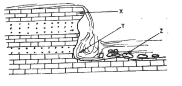
- The diagram below shows a waterfall. Name the features marked X,Y and Z. (3mks)
- The diagram below represents a barchan . Use it to answer question (a)
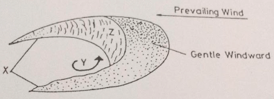
- Name:
- The feature marked X (1mk)
- The air current marked Y (1mk)
- The slope marked Z (1mk)
- Give two ways in which wind transports its load. (2mks)
- Name:
SECTION B (75 MKS)
Answer question 6 and any other two from this section
- Study the map of Kisumu East (1:50,000) provided and use it to answer the following questions.
-
- Identify two human-made features found in the grid square 0095 (2mks)
- Give the six figure grid reference of the Air photo principal point (+05) in the south East. (2mks)
- What is the bearing of Air photo principal point (+47) in grid square 9580 from the Air photo principal point (+72) in grid square 0281. (2mks)
- What is the title of this map. (2mks)
-
- What is the vertical interval (V.I) of the map of Kisumu East (2mks)
- State 3 characteristics of River Ombeyi . (3mks)
- Calculate the area covered by plantation farming in the area covered by the map.(2mks)
South of northing 98
- Describe how relief has influenced distribution of settlement in the area covered by the map. (6mks)
- Identify four social services offered in the Kisumu municipality . (4mks)
-
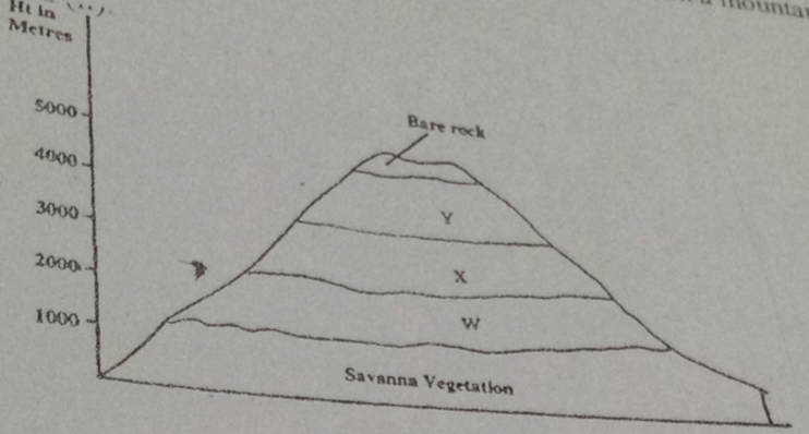
- The diagram below represents zones of natural vegetation on a mountain in Africa .Use it to answer questions (a) (i) and (ii)
-
- Name the vegetation zones marked W,X and Y (3mks)
- Describe the characteristics of the savannah vegetation (6mks)
- Name the temperate grasslands found in the following countries.
- Canada - (1mk)
- Russia - (1mk)
- Australia- (1mk)
- Explain three causes of the decline of the areas under forests in Kenya. (6mks)
- You are supposed to carry out a field study on the uses of vegetation in the area around your school
- State three reasons why it would be necessary to visit the area before the day of the study (3mks)
- Give four uses of vegetation you are likely to identify during the study. (4mks)
-
-
-
- Apart from alternate wetting and drying, name three other processes of mechanical weathering. (3mks)
- Describe the following processes of weathering:
- Alternate wetting and drying (3mks)
- Carbonation (3mks)
- Hydrolysis (2mks)
-
- State three conditions that influence the process of solifluction in mass wasting. (3mks)
- Give three negative effects of mass wasting on the physical environment. (3mks)
- You are planning to carry out a filed study on types of mass wasting
- Identify three methods you would use to collect data (3mks)
- Give three types of rapid mass wasting that you are likely to observe during the field study (3mks)
- State two ways in which the information collected during the field study would be useful to the local community. (2mks)
-
-
- The diagram below shows a breaking sea wave
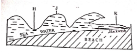
- Name the parts labelled H,J and K (3mks)
- What is a backwash? (2mks)
- Describe three processes of wave erosion along the coast. (6mks)
- Explain how the following factors influence wave deposition:
- Gradient of the shore (4mks)
- Depth of the sea (4mks)
- Using well labelled diagrams, describe how a bay bar is formed (6mks)
- The diagram below shows a breaking sea wave
- The diagram below represents an artesian basin. Use it to answer question (a).
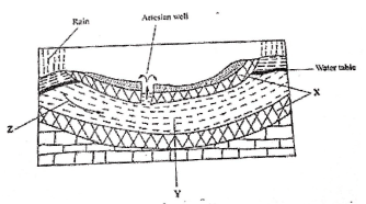
- Identify :
- The layers marked X and Y (2mks)
- The process marked Z (1mk)
- Explain how the following factors influence the amount of underground water in limestone areas:
- Rainfall; (4mks)
- Vegetation cover (4mks)
-
- Apart from stalagmites, name three other underground features formed in limestone areas. (3mks)
- With the aid of a diagram, describe how a stalagmite is formed. (8mks)
- Give three reason why there are few settlements in Karst landscapes (3mks)
- Identify :