
Instructions to Candidates
- This paper consists of two sections; A and B
- Answer all the questions in section A.
- In section B, answer question 6 (compulsory) and any other two questions.
- Candidates should answer the questions in English.
SECTION A
Answer all questions in this section.
-
- What is solar eclipse? (2 marks)
- What is the longitude of a place whose local time is 10.30 a.m., when the local time is 2.00 p.m. at longitude 45°E . (3 marks)
-
- Name two isothermal layers of the atmosphere. (2 marks)
- State three consequences of climate change. (3 marks)
- The diagram below represents features produced by faulting. Use it to answer questions (a) and (b).
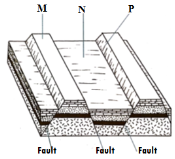
- Identify the features marked M and P. (2 marks)
- State three characteristics of feature marked N in Kenya. (3 marks)
-
- Name two features associated with inland drainage basins in arid areas. (2 marks)
- Give three factors which contribute to the development of deserts. (3 marks)
-
- Distinguish between an ice cap and an iceberg. (2 marks)
- Describe how a glacier transports its load. (3 marks)
SECTION B
Answer question 6 (compulsory) any other two questions from this section.
- Study the map of Nyeri 1:50,000 (sheet 120/4) provided and answer the following questions.
-
- What is the four figure grid reference of Mweiga mission? (2 marks)
- Measure the length of the road D 435. Give your answer in kilometres. (2 marks)
- Give three types of natural vegetation found in the area covered by the map. (3 marks)
-
- Give the approximate height of Nyeri forest guard post. (1 mark)
- Identify two human-made features in grid square 6652. (2 marks)
- Using a vertical scale of 1cm to represent 50 metres;
- Draw a cross section from grid reference 680620 to 730660. (4 marks)
- On the cross section, mark and name the following;
- Hill (1 mark)
- River (1 mark)
- Road D 449 (1 mark)
- Calculate the vertical exaggeration of the cross-section. (2 marks)
- Citing evidence from the map, explain three factors that favour trade in area covered by the map. (6 marks)
-
-
-
- Define the term mineral. (2 marks)
- Give two categories of metallic minerals. (2 marks)
-
- Name the rocks which results from the metamorphism of the following;
- Granite (1 mark)
- Clay (1 mark)
- Sandstone (1 mark)
- State three factors that influence rock metamorphism. (3 marks)
- Name the rocks which results from the metamorphism of the following;
- Describe the formation of the following rocks.
- Intrusive igneous rocks (4 marks)
- Organically formed sedimentary rocks (5 marks)
- Explain three economic benefits of coral rocks. (6 marks)
-
-
- Name two volcanic depressions found on the Rift Valley of Kenya. (2 marks)
- State five characteristics of a composite volcano. (5 marks)
- Describe how the following extrusive features of vulcanicity are formed.
- Geyser. (4 marks)
- Volcanic plug. (4 marks)
- Name three seismic zones in the world. (3 marks)
- Explain four negative effects of earthquakes. (8 marks)
-
- Differentiate between an ocean and a sea. (2 marks)
- Give five conditions necessary for the formation of a beach. (5 marks)
- The diagram below illustrates some of the features formed by wave depositions. Use it to answer the questions that follow.
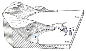
- Identify the features marked Q, R and S. (3 marks)
- Describe the process through which the feature marked P is formed. (4 marks)
-
- Give two causes of submergence of coasts. (2 marks)
- Give three features formed as a result of submergence of coasts. (3 marks)
- You intend to carry out a field study of coastal landforms.
- State two objectives you would formulate for the study. (2 marks)
- Why would you need to seek permission before the study? (3 marks)
-
-
- What is an aquifer? (2 marks)
- Apart from wells state three ways in which underground water may reach the surface of the Earth. (3 marks)
- State four conditions necessary for the formation of artesian well. (4 marks)
- With the aid of well labeled diagrams describe how the following features are formed.
- Limestone pavement. (6 marks)
- Stalagmites. (6 marks)
- State four reasons why Karst landscapes have low population densities. (4 marks)
-
MARKING SCHEME
-
- What is solar eclipse?
- This is a situation when light from the sun does not reach the earth because the moon’s shadow is cast over the earth.
1x2 = 2 marks
- This is a situation when light from the sun does not reach the earth because the moon’s shadow is cast over the earth.
- What is the longitude of a place whose local time is 10.30 a.m., when the local time is 2.00 p.m. at longitude 450E .
2.00 p.m – 10.30 a.m → 210 minutes
Degree → 210 × 1° = 52.5°
4
Longitude → 45°E – 52.5° = 7.5°W
3x1 = 3 marks
- What is solar eclipse?
-
- Name two isothermal layers of the atmosphere.
- Tropopause
- Stratopause
- Mesopause 2x1 = 2 marks
- State three consequences of climate change.
- It can lead to increased rainfall
- Disruption of natural ecosystem
- Shifting of crop growing areas
- Increase in the temperatures
- Rising sea levels/flooding of coastal areas
- Intense storms and hurricanes
- Risk of heat related illness and deaths 3x1 = 3 marks
- Name two isothermal layers of the atmosphere.
- The diagram below represents features produced by faulting. Use it to answer questions (a) and (b).
- Identify the features marked M and P.
- M – Horst/block mountain/fault block
- P – Escarpment/fault scarp 2x1 = 2 marks
- State three characteristics of feature marked N in Kenya.
- The width and depth of the valley varies
- Height of the valley floor varies from one place to another
- The floor has many depressions occupied by lakes
- Volcanic activity on the floor formed volcanic cones 3x1 = 3 marks
- Identify the features marked M and P.
-
- Name two features associated with inland drainage basins in arid areas.
- Alluvial fans/ Bajadas/ Bahadas
- Pediments
- Playas/ Sebkha
- Peripediments
- Salinas 2x1 = 2 marks
- Give three factors which contribute to the development of deserts.
- Insufficient rainfall.
- High temperatures leading to high evaporation.
- Cold ocean currents.
- Relief barriers bring about rain shadow effect.
- Continentality/ nearness to the sea.
- Winds that blow from cooler to warmer latitudes.
- Human activities such as deforestation/ overstocking 3x1 = 3 marks
- Name two features associated with inland drainage basins in arid areas.
-
- Distinguish between an ice cap and an iceberg.
- Ice cap is a (permanent) cover of ice on earth’s surface covering smaller sections of land while an ice berg is a (permanent) floating ice in large water bodies e.g. oceans. 2x1 = 2 marks
- Describe how a glacier transports its load.
- Some load carried at the base or below a glacier as ground maraine
- Load carried along the sides of the glaciers as lateral moraine
- Some load can be carried on the surface but at the centre as medial moraine.
- Sub-glacial/ ground maraine is transported at the bottom/ beneath a glacier 3x1 = 3 marks
Total = 25 marks
- Distinguish between an ice cap and an iceberg.
- Study the map of Nyeri 1:50,000 (sheet 120/4) provided and answer the following questions.
-
- What is the four figure grid reference of Mweiga mission?
677651 - Measure the length of the road D 435. Give your answer in kilometres.
7.5 ± 0.1 km - Give three types of natural vegetation found in the area covered by the map.
- Forest
- Bomboo
- Scrub
- Woodland 3x1 = 3 marks
- What is the four figure grid reference of Mweiga mission?
-
- Give the approximate height of Nyeri forest guard post.
1800 metres (above the sea level) 1x1 = 1 mark - Identify two human-made features in grid square 6652.
- Houses/ settlement
- Road 2x1 = 2 marks
- Give the approximate height of Nyeri forest guard post.
- Using a vertical scale of 1cm to represent 40 metres;
- Draw a cross section from grid reference 680620 to 730660.
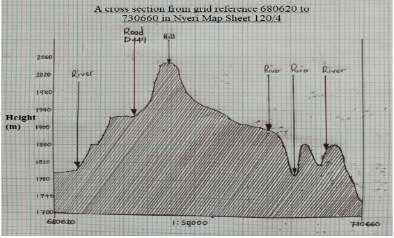
- On the cross section, mark and name the following;
- Hill 1x1 = 1 mark
- River 1x1 = 1 mark
- Road D 449 1x1 = 1 mark
- Calculate the vertical exaggeration of the cross-section.
Vertical Exaggeration (VE) = Vertical Scale (VS)
Horizontal Scale (HS)
= 1/40 ÷ 1/50,000
= 1/40 x 50,000/1
= 12.5 times
2x1 = 2 marks
- Draw a cross section from grid reference 680620 to 730660.
- Citing evidence from the map, explain three factors that favour trade in area covered by the map.
- Well-developed road network e.g. road D 449 facilitating faster/ cheap means of transporting goods to the market.
- Large population indicated by dense settlement provides a large ready market/ high demand for the goods.
- Many market centres e.g. Kanjora and Ihuru market.
- Presence of a variety of economic activities e.g. coffee processing at Kamwenje, Forestry at Aberdare forest
3x2 = 6 marks
Total = 25 marks
-
-
-
- Define the term mineral.
- Minerals are inorganic substances which occur naturally at or beneath the surface of the earth. 1x2 = 2 marks
- Give two categories of metallic minerals.
- Ferrous
- Non-ferrous 2x1 = 2 marks
- Define the term mineral.
-
- Name the rocks which results from the metamorphism of the following;
- Granite - Gneiss 1x1 = 1 mark
- Clay - Slate 1x1 = 1 mark
- Sandstone - Quartzite 1x1 = 1 mark
- State three factors that influence rock metamorphism.
- Mineral composition of the parent rock
- Temperature at which metamorphism takes place.
- The amount/ intensity and type (direction) of pressure during metamorphism.
- The amount and type of fluid (mostly water) that is present during metamorphism.
- The length of time available for the metamorphism process. 3x1 = 3 marks
- Name the rocks which results from the metamorphism of the following;
- Describe the formation of the following rocks.
- Intrusive igneous rocks
- Tectonic forces/ earth movement results to the formation of cracks/faults within the crustal rocks.
- Magma is forced out of the mantle under pressure.
- Magma is deposited within the cracks/ fissures/ joints/ bedding planes within the crustal rocks.
- Magma cools and solidifies to form intrusive igneous rock. 4x1 = 4 marks
- Organically formed sedimentary rocks
- The remains of dead plants and animals are carried/transported by wind, water or ice and deposited on land or in water.
- Continued deposition result to new layers of remains deposited over the previously laid down materials/ Deposits accumulate over long periods of time.
- Lower layers are compressed by the weight of the overlying layers.
- Lower layers are compacted to form various types of rocks. 4x1 = 4 marks
- Intrusive igneous rocks
- Explain three economic benefits of coral rocks.
- In some areas, the rocks form spectacular/fascinating features like coral reefs that are of tourist attractions thus earning foreign exchange.
- Some coral rocks are excavated to be used in building and construction
- Some rocks sold in quarries hence sources of income to people and improve their living standards.
- Coral ecosystems form rich fisheries that promote fishing which is a source of income/ food. 3x2 = 6 marks
Total = 25 marks
-
-
- Name two volcanic depressions found on the Rift Valley of Kenya.
- Menengai caldera.
- Longonot caldera.
- Crater on Central Island of Lake Turkana.
- Suswa caldera. 2x1 = 2 marks
- State four characteristics of a composite volcano.
- It has a vertical vent
- It has a side vents
- It is composed of alternating layers of pyroclasts and lava.
- It’s conical shaped
- It’s steep sided
- It has conelets/parasitic cones on the sides.
- At the peak it may have a crater, caldera/volcanic plug. 5x1 = 5 marks
- Describe how the following extrusive features of vulcanicity are formed.
- Geyser.
- Underground water in contact with hot rocks and gets super-heated and becomes vapour/steam and expand.
- The steam gets under high pressure.
- Steam and water is forced out of the ground explosively through pipes or craks.
- Cooler water flows into the pipes to replace lost water and heating begins. 4x1 = 4 marks
- Volcanic plug.
- Tectonic forces create lines of weakness forming a vent.
- Vent eruption leads to formation of a volcano.
- After eruption viscous magma may cool and solidify within the vent.
- If the surrounding rocks are less resistant, they may be eroded to leave a resistant standing feature above the earth’s surface called a volcanic plug/neck. 4x1 = 4 marks
- Geyser.
- Name three seismic zones in the world.
- Circum – Pacific belt/ring of fire/around Japan, Philippines, East Indies and the Americas.
- The Mediterranean belt across southern Europe, southern Asia and the Himalayas/ Mediterranean -Malayan belt
- Fold mountain regions of the world.
- Rift valley regions/ other named faulted areas.
- Mid-Atlantic Ocean ridges. 3x1 = 3 marks
- Explain four negative effects of earthquakes.
- Loss of life and property- trembling cause shock collapse of building/ can trigger landslides and can bury people.
- Permanent displacement of land hence destroying infrastructure e.g. pipelines, roads, bridges, electricity and water lines.
- Lower or raise the sea level leading to emergence or submergence of coasts
- Restrictions on development of towns/urban centres e.g. restricting development of tall/storey buildings.
- Earthquakes tend to trigger fires hence occurrence of fire after an earthquake is a common feature.
- Cause tsunamis i.e. sub-marine shock-waves generated by earthquake – this can interfere with marine tourism/ interruption of sea transport/ Flooding of lower coastal areas. 4x2 = 8 marks
Total 25 marks
- Name two volcanic depressions found on the Rift Valley of Kenya.
-
- Differentiate between an ocean and a sea.
- vast bodies of saline/salty water on the earth’s surface that surrounds the land or continent while a sea is a large salty water bodies surrounded by land but lack connection/outlet with the oceans e.g. Caspian Sea, Aral Sea, Dead Sea/ large salty water bodies joined to/separated from the oceans through a submerged rock sill/strait e.g. Mediterranean Sea (connected to the Atlantic Ocean through a strait – Gilbatar). Others are Red, Black and Baltic seas/ Smaller divisions of oceans referred to as marginal seas i.e. are at the margins of the four oceans e.g. Caribbean Sea, Arabian Sea, North China Sea, etc. 2x1 = 2 marks
- Give five conditions necessary for the formation of a beach.
- They form where the land slopes gently into the sea at the head of bays.
- The waves must be constructive.
- Requires relatively calm weather.
- The waves should carry large quantities of load (sand, shingle).
- Occurrence of low and high tides.
- Presence of boulders, sand and coral fragments. 5x1 = 5 marks
- The diagram below illustrates some of the features formed by wave depositions. Use it to answer the questions that follow.
- Identify the features marked Q, R and S.
- Q – Arch
- R – Wave-cut platform
- S – Stack 3x1 = 3 marks
- Describe the process through which the feature marked P is formed.
- The breaking waves attack the steep/highland coast through hydraulic action and abrasion creating a notch at the position where they break at high tide.
- Continued wave attack makes the notch to be more pronounced and wider.
- The upper part of the rock face where waves do not reach is attacked by agents of weathering forming an overhanging cliff.
- Continued undercutting by breaking waves may cause the overhanging cliff to collapse leaving a steep/vertical/inclined rock face bordering the sea called a cliff. 4x1 = 4 marks
- Identify the features marked Q, R and S.
-
- Give two causes of submergence of coasts.
- Rise in sea level/eustatic change in the base level.
- Subsidence of coastal land/ isostatic adjustment/ downward movement of coastal land. 2x1 = 2 marks
- Give three features formed as a result of submergence of coasts.
- Islands
- Mudflats/swamps/marshes
- Broad continental shelf
- Fiords
- Rias/Creeks
- Sounds
- Estuaries 3x1 = 3 marks
- Give two causes of submergence of coasts.
- You intend to carry out a field study of coastal landforms.
- State two objectives you would formulate for the study.
- To find out / To identify the features of deposition found at the Kenyan coast.
- To find out/ To establish the significance of coastal landforms to human activities
- To find out/ To investigate the problems associated with coastal features. 2x1 = 2 marks
- Why would you need to seek permission before the study?
- To avoid being denied access on the actual day of field study.
- To acquire relevant documents required for the study.
- To enable the administration to arrange for transport/ meals/ entry fee etc. 2x1 = 2 marks
Total = 25 marks
- State two objectives you would formulate for the study.
- Differentiate between an ocean and a sea.
-
-
- What is an aquifer?
- This is a permeable rock, which can hold water and allow it to pass through its pores/ cracks. 1x2 = 2 marks
- Apart from wells state three ways in which underground water may reach the surface of the Earth.
- Springs.
- Geysers.
- Capillary action/Transpiration.
- Oases. 3x1 = 3 marks
- State four conditions necessary for the formation of artesian well.
- The aquifer must outcrop in a region which is a source of water e.g. a rainy area or beneath a lake/must be exposed in an area of sufficient rainfall
- The aquifer must be sandwiched between impermeable rocks so that it can retain water.
- The aquifer must dip towards a region where the land surface is lower than it is at the exposed end of the previous formation
- The mouth of the well must be lower compared to the intake area to allow the water to be forced to the surface by pressure with no need of pumping. 4x1 = 4 marks
- What is an aquifer?
- With the aid of well labeled diagrams describe how the following features are formed.
- Grikes and clints.
- Rain water absorbs carbon (IV) oxide to form weak carbonic acid.
- Carbonic acid reacts with limestone within the surface within the cracks/ joints to form soluble calcium hydrogen carbonate.
- Water enters the joints and dissolves calcium hydrogen carbonate hence widening and deepening the joints to form irregular gullies called grikes.
- Grikes are separated by ridges called clints
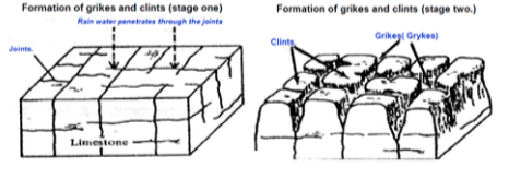
Text 4x1 = 4 marks
Diagrams 2 marks
Total 6 Marks
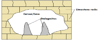
- Stalagmites.
- These are underground stumpy rock masses that grow from the floor of the cave upwards.
- When drops of water containing calcium bicarbonate hangs on the roof of a cave, some water drips onto the floor of the cave.
- This water spread out, evaporates and leaves behind crystals of calcium bicarbonate.
- This process continues with time and the crystals grow upwards towards the roof of the cave to form a stalagmite.
Text 4x1 = 4 marks
Diagrams 2 marks
Total 6 Marks
Total = 25 Marks
THE END
- Grikes and clints.
-
Join our whatsapp group for latest updates
Tap Here to Download for 50/-
Get on WhatsApp for 50/-
Download Geography Paper 1 Questions and Answers - Maranda High School Mock Exams 2023.
Tap Here to Download for 50/-
Get on WhatsApp for 50/-
Why download?
- ✔ To read offline at any time.
- ✔ To Print at your convenience
- ✔ Share Easily with Friends / Students