- The Main Physical Features In Kenya
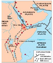
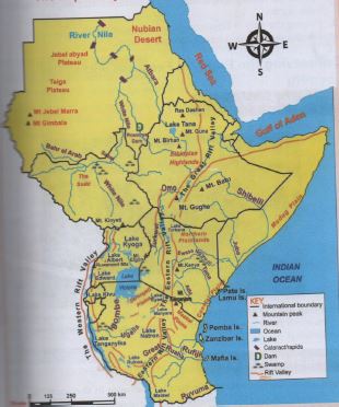
- Map Of Eastern African Showing Main Physical Features
- Conserving The Physical Features Within The Locality
- Physical features are naturally things found on the surface of the earth
- They include:
- Mountains
- Valleys
- Plateaus
- Ocean
- Seas
- Gorges
- Plains
- Lakes
- Rivers
- Swamps
- Hills, rangers

The Main Physical Features In Kenya
- Mountains
- Are masses of very high land.
- They are the highest physical features on the earth.
- Major mountains in Eastern Africa
KENYA TANZANIA UGANDA SUDAN ETHIOPIA Mt.kenya Mt.kilimanjaro Ruwenzori Jabel-marra Ras dashan Mt.longonot Mt.meru Nubadarfur Guna Mt.marsabit Pare mts Kissu Danakil alps Mt .kulal Ngorongoro crater Menengai crater Lool molasin
- Rift valley
- A valley is a low lying are with steep slopes.
- In Eastern African the rift valley has 2 branches that stretch across several countries
- The two branches are the eastern rift valley and the western rift valley
- Lakes
- A lake is a water body that is surrounded by land
- A hollow/depression filled with water
- We have
- Fresh water lakes
- sailty water lakes
- Main lakes in eastern Africa are
KENYA UGANDA TANZANIA ETHIOPIA RWANDA Turkana
Baringo
Bogoria
Nakuru
Elementaita
Naivasha
Magadi
Jipe
ChalaAlbert
Edward
Bunyonyi
Bisini
George
Kyoga
Kivu
mutandaNatron
Manyara
eyasi
Rukwa
Malawi
tanganyikaChamo
Abaya
Steffanie
Shala
tanaruhondo
kivu
- Plains
- Are low lying areas of almost flat land.
- Examples
KENYA UGANDA TANZANIA SOMALIA Lotikipi, awara, kano, Luwero Serengeti Bilesha Kaputei, loita, Nakasongola maasai Sarar Budalangi,kapiti Haded bilesha

Formation Of Main Physical Features Of Eastern Africa
Formation Of Volcanic Mountains
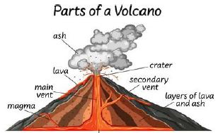
- They are also called volcanoes
- They are formed through the process of volcanicity/eruption.
- Eruption is when the hot molten material underground is forced out by great pressure
- The hot molten material is called magma
- When magma gets to the surface is called lava
- The magma gets out through a main pipe called vent
- The opening at the top of a volcanic mountain is called a crater
- Most mountains in eastern africa are volcaning mountains
KENYA TANZANIA RWANDA Kenya
Elgon
Longonot
Menengai crater
Marsabit
Suswa
KulalMt meru
Mt Kilimanjaro
Ngorongoro
Lool malsinMt karisimbi
Nyiragongo
Formation of Block Mountains
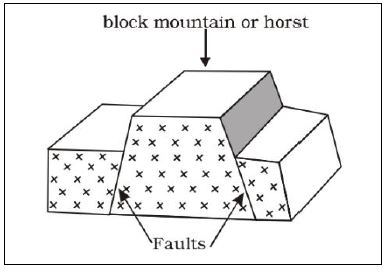
- They are also called horst mountains
- They were formed through faulting and uplifting process
- Faults are lines of weakness
- Faults were developed as a result of forces acting on the layers of the earth
- The forces involved are tensional and compressional forces
- The middle block was pushed upward by underground forces
- The underground forces called up thrust force
- Examples
ETHIOPIA UGANDA TANZANIA Danakali alps ruwenzori Pare
usambara
Formation Of The Rift Valley
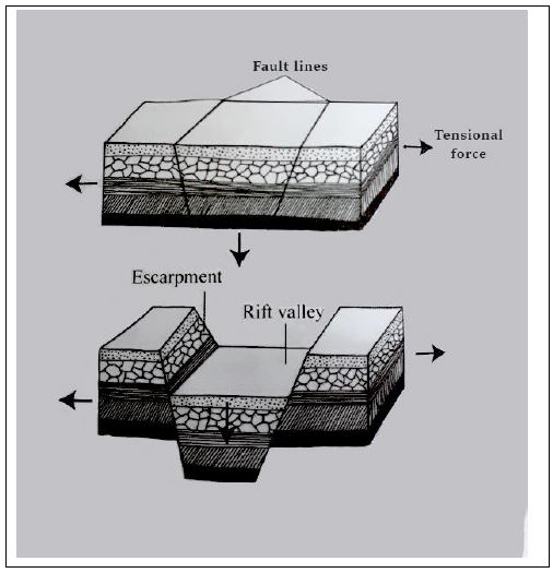
- The rift valley was formed when two cracks or fault line formed within the crustal rocks
- The land between the two faults sunk forming a valley
- Was formed through the faulting process
- Formed by either tensional or compressional forces
- When two parallel faults developed the tensional forces pulls the rocks apart
- The middle block between the faults sink
- The steep sides of a rift valley are called escarpments
Formation Of Lakes
- The major lakes in eastern African were formed as a result of
- Faulting
- River deposition
- Down warping
- Volcanicity
Rift Valley Lakes
- During the formation of the rift valley, some parts of the land sunk deeper than others forming depressions.
- The depressions were filled with water to form lakes
- Example – lake Tanganyika in TZ
Lakes Formed As A Result Of Down Warping
- Down warping is a process by which the earth sinks inwards due to pressure forming a big basin.
- Water fills this basin to form a lake.
Example: lake Victoria in Kenya
Lakes Formed As A Result Of Volcanicity
- Lava dammed
- Lava dammed lakes are formed when lava flow on the surface of the earth and comes int contact with a river, blocking it
- This leads to the formation of a lake
Example: lake kivu in Rwanda
- Crater lakes
- When volcanic eruption occurs, the top of the mountain may be blown of forming a hallow depression called crater.
- Water fills the hallow depression forming a crater lake.
- Example; Lake paradaise in Kenya, Ngozi in Tanzania and Shalla in Ethiopia.
Formation Of Plains
- Plains are wide low lying areas of flat land.
- Plains are formed as a result of erosion and deposition of the eroded materials.
Map Of Eastern African Showing Main Physical Features
Conserving The Physical Features Within The Locality
We should protect and conserve physical features found in our locality
- Prevent overuse and deforestation of forest.
- Avoid pollution of water bodies.
- Educate people on importance of physical features.
Join our whatsapp group for latest updates
Tap Here to Download for 30/-
Get on WhatsApp for 30/-
Download Main Physical Features in Eastern Africa - Social Studies CBC Grade 6 Notes.
Tap Here to Download for 30/-
Get on WhatsApp for 30/-
Why download?
- ✔ To read offline at any time.
- ✔ To Print at your convenience
- ✔ Share Easily with Friends / Students

