
- Physical Environment
- Map Reading And Intepretation
- Physical Features
- Climate
- Soil

Physical Environment
What is Environment?
The things around us or in our surrounding make up the environment.
Examples
- Trees
- Animals
- Water etc.
- Grass
- Rivers
- Buildings
- Birds
Types of Environment
- Natural environment
These were things that were made by God. E.g Mountains ,Lakes, Rivers, Vegetation etc. - Human environment
These are things made through man`s efforts e.g Dams, buildings, roads, etc. - Physical environment
The non – living part of the environment which consists of Soils, air, rocks, water, hills, mountains, rivers and lakes form the physical environment.
Map Reading And Interpretation.
A map is a drawing on a flat surface that represents a whole part of the earth.
Elements of a Map
Elements of a map helps a reader to understand the information on a given
map.
The main element of a map are:
- Title
- Key
- Compress
- Frame
- Scales
Uses of Elements of a Map
| ELEMENT | USE(S) |
| Title | It is the name of the area represented by the map and the information it contains. |
| Frame | It shows the extent of the area represented by a map. It is also known as the borderline of a map. |
| Key | It contains the signs or the symbols which represents various features represented in a map. |
| Compass Direction |
Helps to find direction of a position or features in relation to others |
| Scale | Helps the map reader to know the actual distance on the earth`s surface as reprtesented on the map |
Map Reading
This is the ability to read, understand, and interpret information given on a
map.
Symbols of a map contained in the key should be fully understood and
interpreted correctly.
Features That Can be Interpreted From a Map
- Relief and drainage patterns in the area.
- Human and economic activities in the area.
- Types of climate experienced in the area.
- Transport facilities in the area.
- Vegetation found in the area.
- Human settlement pattern in the area.
- Administrative boundaries in the area.
- Social activities (services) found in the area.
Human Activities Commonly Found in a Map
Economic activities are the objectives that people carry out in order to get
income (money).
Examples
| Economic activity |
Evidence |
| Crop farming | Crops e.g coffee, tea, sisal, sugarcane, cotton, pyrethrum, wheat and cotton ginneries, factories, plantations, mills. |
| Forestry | Presence of saw mill, timber yard, forest guard, posts. |
| Livestock farming | Presence of cattle dips, butcheries, slaughter houses, cattle boma, dairy farms, creamery, veterinary offices, ranches, beef factories, trough. |
| Tourism | Presence of national parks, game reserves, camping sites, picnic sites, hotels, lodges, museums, pre-historic sites. |
| Fishing | Presence of fish ponds, fishing villages, a fish factory, fish traps, fisheries departments. |
| Mining | Presence of quarry, symbols of mines, name of the mine like Salt mining works. |
| Trade | Presence of markets, shops, trade license office, trading centers, warehouses, stores, towns, custom offices |
| Industry | Manufacturing factories, bakeries, refineries, rolling mills, ginneries, saw mill. |
| Transport and communication |
Roads, railway lines, airports, airstrips, ports, post offices, telephone lines. |
Social Activities on a Map
- Religious activities : Churches, mosques, temples, shrines.
- Medical services : Clinics, dispensaries, health centers, district hospital, provincial hospitals and National hospitals.
- Education: Schools, colleges, polytechnics, universities.
- Recreation : Cinema halls, Social halls, play grounds, theatres.
Features on a Map That Represents Administration
- Government offices e.g. Assistant chief`s offices or chief`s camp.
- Police post.
- Administrative boundaries.
Features That Show Drainage Systems on a Map
| Drainage features | Interpretation |
| Boreholes and wells | Areas of low and unreliable rainfall. |
| Permanent rivers | Areas that receive high rainfall. |
| Seasonal rivers | Areas of low rainfall. |
| Waterfall | Areas of hard and soft rocks. |
| Many swamps | Clay soils, poorly drained areas. |
| Tributaries | Direction of the flow of the river |
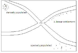
Human Settlement on the Map
Settlement is the pattern of population distribution in an area shown by dots and black shades.
Types of Settlement
How to Identify the Functions of a Town on a Map
| Functions of the urban centre | Identification symbol |
| Administrative centre | Government offices, chief`s camp, law courts, police posts, prisons, administrative boundaries. |
| Commercial centres | Shops, markets, road functions, trading centers, towns, cities, warehouses, stores, trade licensing offices. |
| Social centres | Schools, colleges, mosque, churches, theatres, sports, grounds, hospitals, cinema halls. |
| Mining centres | Mining works, quarries, named mines. |
| Agricultural centres | Food stores, Large estates, or plantations, processing factories, dairy, creameries, cattle ranches, cattle dips, dairy farm. |
Physical Features
These are things we see on the surface of the earth. They include natural physical features and man-made(human)
Natural features: Mountains, plateaus, hills, plains, valleys, rivers, lakes, etc.
Man-made: dams, lakes etc.
The Effects of Physical Features on Human Activities
| Physical features | Human activities | |
| Lakes, oceans, rivers |
|
|
| Ocean, lakes | ||
| Snow capped mountains |
|
|
| Rift valley | ||
| Beautiful water falls | ||
| Sand beaches | ||
| Hot springs | ||
| Homa hills(limestone) |
|
|
| Lake Magadi(Soda ash) |
|
|
| Indian ocean(salt) |
|
|
Negative Effects of Physical Features
- Flooding.
- Water borne diseases e.g. Malaria and Bilharzia.
Climate
Traditional Methods of Observing Weather
- Observing the sky
- Thick grey clouds: rain.
- Certain stars arranged in a particular manner: dry spell.
- Phases of the moon
- New moon: rain.
- Full moon: It would rarely rain.
- Appearance of the rainbow
- Some communities believed that it would not rain if the rainbow appears in the sky when it was about to ran
- Condition of the environment
- Very hot and humid: Coming of the rain.
- Blowing of wind
- Strong winds blowing after a dry weather: Showed the coming of the rains
- Wind blowing during the rainy season: Meant chasing away of the rain to give way to a dry spell.
- Behavior of birds:
- Happy and playful birds in the sky would signify the coming of rains.
- Trail of ants: Signified the coming of rains.
- Croaking of frogs: Signified the coming of the rain.
- Appearance of toads: Signified the coming of the rains.
- Behavior of cattle: Coming of the rains(showing happiness by jumping up and down)
- Shedding of leaves after a rainy season: This Signified a dry spell.
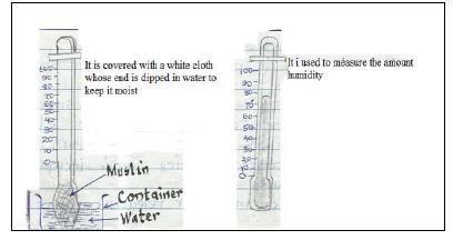
Observation, Measurement and Recording of Weather Elements
What is meteorology?
It is the science of observing and measuring weather elements.
-
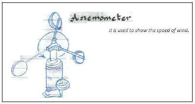
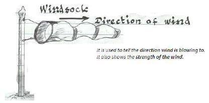
Wind

-
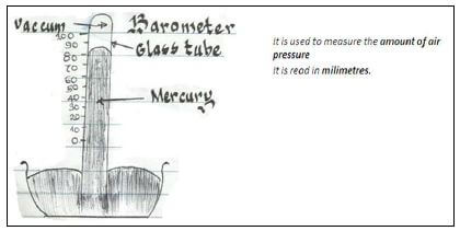
Air Pressure
-
Rainfall
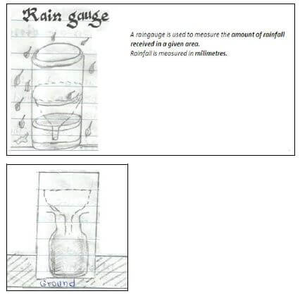
The raingauge is dug into the ground as shown above. -
Temperature
- Minimum and maximum thermometer
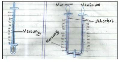
Used to measure temperature for the day.
It is U-shaped.
Minimum records coldest temperature.
Maximum records warmest temperatures. - Single-tube thermometer
Used to measure coldness and / or hotness of the air.
It is marked in o Celsius.
It may contain alcohol or mercury.
- Minimum and maximum thermometer
Factors Influencing Climate Change
Climate change is the occurrence of unexpected change of climatic condition in a particular region. The main factors influencing climate change include:-
- Deforestation
Cutting down of trees leads to reduced amount of rainfall.
It creates desert – like conditions in the areas previously occupied by forests.
It contributes to increased carbon dioxide in the atmosphere. - Afforestration and re-afforestration
Planting of more trees will increase the amount of rainfall.
Both afforestration and re-afforestration reduce soil erosion and evaporation, hence protecting water catchment areas. - Industrialization
Heat and smoke from industries cause pollution and increase temperature in the atmosphere. - Excess use of chemicals
Such as fertilizers causes atmospheric change due to the gasses they produce.
The growing of rice under irrigation contributes to warming of the atmosphere. The rice in water release a gas known as methane, which
contributes to global warming. The same applies to the use of fertilizers.
Global warming is also caused by the use of petroleum to run vehicles .Machines give off a gas known as carbon monoxide, which makes
the air warmer. - Clearing of vegetation for agriculture
This exposes the soil to agents of soil erosion. - Building of dams
Human-made lakes which form behind the dam modify the climate. - Ocean currents
These leads to temperature change along the coastal areas.
Impact of Climate Change on Human Activities
Positive effects
- Increase in food production due to increased amount of rainfall
- Increased generation of hidro-electric power due to high rainfall.
- Promotion of fishing due to adequate water in rivers.
Negative effects
- Low agricultural production due to lack of rains.
- Displacement of people due to floods.
- Global warming as a result of general increase in temperature worldwide.
- Increase of water-borne diseases such as malaria and bilharzias due to increased rains.
- Damage of transport systems e.g. roads.
- Migration of people migration of people to favourable climate.
- Death of human beings.
Soil
Soil is formed through a process called weathering. Soil contains:
- Organic matter
- Rock particles
- Humus
- Air
- Minerals
- Water
- Living organisms
Major Soil Types in Kenya
- Volcanic soils.
- Clay (black cotton) soil.
- Sandy soil.
- Loamy soil.
- Alluvial (young) soil.
Characteristics of Types of Soil
Volcanic Soil
- Red in colour.
- Deep fertile and well-drained.
- Occur in layers.
- Medium – sized soil particles.
- Mainly found in the highlands.
Clay( Black Cotton) Soil
- Small – sized particles.
- Dark in colour
- Deep and fertile
- Poorly drained.
- Muddy and sticky during the rainy season.
- Big cracks during dry seasons.
Sandy Soil
- Large soil particles.
- Shallow and dry.
- Contains a lot of air.
- Water seeps through them fast.
- Low water retention capacity.
- Loose nutrients mainly through leaching.
Loamy Soil
- It has a mixture of small, medium and large soil particles.
- It retains a reasonable amount of water fertile, deep and well drained.
- Appears in different colours e.g. light grey, dark brown and dark grey.
Alluvial (Young) Soil
- They are found in river valleys and flood plains.
- They are made of slits.
- Soil particles are of medium size.
- Have a smooth texture.
- They are deep and fertile.
Major Causes of Soil Erosion
Soil erosion is the natural displacement of soil from the original place of formation to another by agents of erosion like wind, water and human beings.
The major causes of soil erosion are as follows:
- Deforestation- Cutting down of trees which exposes the soil to agents of soil erosion.
- Overstocking- Keeping large herds of livestock beyond the capacity of land leading to overgrazing
- Overgrazing-Livestock grazing on all pasture (vegetation) leaving the ground bare.
- Monocropping-Growing of one type of crop on the same peace of land year after year exhausts soil fertility.
- Over-cropping-Growing of many different types of crops which compete for nutrients. The soil finally becomes loose and infertile
- Up-the-slope (hill) cultivation-This promotes gulley erosion.
- Mining and quarrying-Results to displacement of soil.
Effects of Soil Erosion on Human Activities
- Destocking (reducing the number of livestock on the farm)
- Application of fertilizers to the soil in order to increase its fertility.
- Introduction of afforestration and re-afforestrationprogrammes
- Promotion of agriculture in the flood plain where fertile soil (alluvial) is deposited.
- Adoption of good farming methods to reduce soil erosion.
- Additional expense to the government in building dams, dykes and canals.
Soil Conservation Measures
- Afforestration :
Planting of trees. - Re- afforestration:
Planting of trees where they had been cut down. - Agro-forestry:
Planting of trees together with crops. - Crop rotation:-
Growing of different crops on the same peace of land in alternate planting seasons. - Mulching: The covering of the bare ground with grass to prevent moisture loss.
- Cover cropping:
Planting of perennial crops like coffee and bananas together with food crops likepotatoes, beans and maize. - Construction of gabions:
Pilling up of stones in iron cages to prevent further movement of soil downhill. - Terracing:
Making of horizontal steps on sides of hilly areas. - Fallowing:
Leaving the land idle for some time in order to retain its fertility. - Creation of cut-off- drainage:
This is the digging of trenches to divert water from hill tops - Controlled grazing:
This is done by subdividing land into paddocks. - Use of fertilizers and manure:
This helps the soil to regain its fertility. - Contour ploughing:
This is ploughing of farm across the land guarded by the contours.
Download Physical Environment - Class 8 Social Studies Revision Notes.
Tap Here to Download for 30/-
Get on WhatsApp for 30/-
Why download?
- ✔ To read offline at any time.
- ✔ To Print at your convenience
- ✔ Share Easily with Friends / Students