
Scale Drawing
Worked Exercise
- The distance between two villages is 6.4KM. On the map of the region this distance is represented by a line 1.6 cm long. What is the scale of the map?
- 1: 400000
- 1: 40000
- 1: 4000
- 1: 4
Working
Actual distance = 6.4 km
Drawing length = 1.6cm
1 cm on the map = 6.4/1.6
= 4km on the ground
But 1 km = (1000 x 100) cm
4km = 4 x 1000 x 100
= 400000cm
Therefore scale = 1: 400000
The correct answer is A (1: 400000)
- A rectangular field measures 105 m. On a scale drawing of the field, the longer side is 7cm.What is the measurement of the width on this scale drawing?
- 5 cm
- 50 cm
- 500 cm
- 7.35cm
Working
7 cm represents 105 m
1 cm represents (105 ÷ 7)
Scale used,
1 cm represents 15m
? 75m
= (75 x 1)/15
5cm
The correct answer is 5cm (A)
- The scale on a plan is 1:20. How many cm will represent 1m on this plan?
- 50 cm
- 50 cm
- 5 cm
- 2 cm
Working
1 : 20 scale means 1 cm on a drawing represents 20 cm on the ground.
1 cm represents 20cm
? 100cm
=100/20
= 5cm
The correct answer is C (5cm)
- A rectangular field measuring 720m by 550m is to be represented on a scale drawing using the scale 1: 10,000. What is the perimeter of the drawing in centimetres?
- 0.254
- 2.54
- 25.4
- 254
Working
1: 10000 means 1 cm on the map represents 10000 cm on the ground
If 1 cm = 10,0000cm
? = 72,000cm
= (72000/10000) cm
= 7.2cm
If 1cm = 10,000cm
= 55,000cm
= ( 55,000/10,000 ) cm
= 5.5cm
Perimeter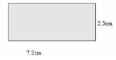
P = 2(L+W)
= 2 (7.2 + 5.5)
= 25.4 cm
The correct answer is (C)
- The scale of a map is 1: 50000. What is the length of this map of a road 20km long?
- 40cm
- 400 cm
- 4000 cm
- 4 cm
Working
Scale 1 : 50000 means 1cm on the map represents 50000 cm on the ground.
20 km = 20 x 1000 x 100
= 2000000 cm
50,000cm represents = 1 cm
2,000,000 represents = 2,000,000 ÷ 50,000
= 40cm
The correct answer is A (40 cm)
Join our whatsapp group for latest updates
Tap Here to Download for 30/-
Get on WhatsApp for 30/-
Download Scale Drawing - Class 8 Mathematics Revision Notes.
Tap Here to Download for 30/-
Get on WhatsApp for 30/-
Why download?
- ✔ To read offline at any time.
- ✔ To Print at your convenience
- ✔ Share Easily with Friends / Students