
Questions
INSTRUCTION TO CANDIDATE.
- This paper has two sections A and B.
- Answer All questions in section A.
- In section B, Answer question six and any other two questions.
SECTION A- 25 MARKS
-
- What is Geography? (2 mks)
- Name three sub-branches of physical Geography. (3 mks)
-
- What is an Earthquake? (2 mks)
- Name three types of earthquakes, depending on the depth of focus. (3 mks)
-
- What is river capture?
- State three conditions necessary for the river capture to occur. (3 mks)
-
- What is vegetation? (2 mks)
- Name the three types of vegetation (3 mks)
-
- State three reasons why wind is a dominant agent of erosion in arid areas (2 mks)
- Name the three ways through which materials are transported by wind. (3 mks)
SECTION B
Answer question 6 and any other two questions in this section
- You are provided with a map of Nyeri East Africa 1:50000 (KENYA) Sheet 120/4.Use it to answer the questions that follows.
-
- Give title of the map extract provided. (1mk)
- Name the two districts that have been captured in this map (2mks)
- Give the magnetic variation of the area covered by the map extract (2mks)
-
- Convert the scale of this map into a statement scale (2mks)
- Highlight two types of vegetation found to the east of easting 77 (2mks)
-
- Calculate the total area covered by the forest to the east of easting 69 and west of easting 76.Give your answer in km2 (2mks)
- Give the bearing of the trigonometrical station at grid square 6556 from the trigonometrical station at grid square 6150. (2mks)
-
- On the graph paper provided draw a cross section from point 680640 to point 770640 on the area covered by the map using a vertical scale of 1cm rep 50m. (4mks)
- On it mark and label all weather road loose surface (1mk)
- Calculate the vertical exaggeration of the cross section (2mks)
- Citing evidence from the map give five social services offered in NYERI TOWN. (5MKS)
-
-
-
- What is a weather station? (2mks)
- State four factors considered when citing a weather station. (4mks)
- Explain how the following factors affect temperature
- Aspect (2mks)
- Ocean currents (2mks)
- Altitude (2mks)
- Study the diagram below and use it to answer the questions that follow.
- State two ways through which the above phenomenon influence the climate of the adjacent land. (2mks)
- Identify areas in western Kenya where the phenomenon shown in the diagram above commonly occurs. (1mks)
- With aid of a well labeled diagram, explain formation of relief rainfall. (6mks)
- Give four reasons why weather forecasting is important. (4mks)
-
-
-
- What is a limb in a fold? (2mks)
- Explain how Fold Mountains are formed according to convectional current theory (3mks)
-
- Differentiate between orogeny and orogenesis (2mks)
- State three factors influencing folding of sedimentary rocks. (3mks)
-
- Use the world map provided and answer the questions that follow.
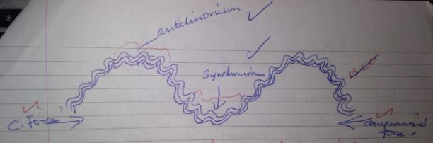
Name mountain ranges marked U, V, W, X, Y and Z (6mks) - Draw a well labeled diagram of anticlinorium and synclinorium complex fold (3mks)
- Use the world map provided and answer the questions that follow.
- Explain three ways in which fold mountains influence climate in a region. (6mks)
-
-
-
- Name two types of submerged highland coasts. (2mks)
- Identify two resultant features of the emerged highland coasts. (2mks)
- State three factors influencing deposition by ocean waves. (3mks
- Describe the formation of the following coastal features:
- Fringing reef (5mks)
- Spit (5mks)
- Explain four significance of oceans to human activities. (8mks)
-
-
-
- Differentiate between an ice berg and an ice sheet. (2mks)
- Identify Four ways through which ice moves (4mks)
- Describe the following processes of glacial erosion.
- Plucking (4mks)
- Abrasion (4mks)
- Describe how a glacial trough is formed. (5mks)
- Students of Gitugi secondary school carried out a field study on glaciation on Mt. Kenya.
- Give three reasons why they conducted a reconnaissance (3mks)
- Give three activities they may have been involved in during the study. (3mks)
- Formulate one hypothesis that would have been relevant for study. (1mk)
-
Marking Scheme
-
- What is Geography? (2 mks)
- This refers to the scientific study of the earth as a home of mankind
OR
It is the study of distribution and inter-relationship of the natural and human phenomena on the earth’s surface
- This refers to the scientific study of the earth as a home of mankind
- Name 3 sub-branches of physical Geography. (3 mks)
- Geomorphology
- Climatology
- Biogeography
- What is Geography? (2 mks)
-
- What is an Earthquake? (2 mks)
- This refers to a sudden and rapid earth movement which causes vibrations in the rocks of the crust
- Name three types of earthquakes, depending on the depth of focus. (3 mks)
- Shallow focus earthquake
- Intermediate focus earthquake
- Deep focus earthquakes.
- What is an Earthquake? (2 mks)
-
- What is river capture? (2mks)
- This is the diversion of the head waters of a weak river into the system of an adjacent more powerful river due to erosion.
- State three conditions necessary for river capture to occur. (3 mks)
- more powerful river and a less powerful river flow parallel or adjacent to each other downslope
- The pirate river flows at a lower level than the weaker river.
- The pirate river has a higher water volume than the weaker river.
- What is river capture? (2mks)
-
- What is vegetation? (2 mks)
- Plant cover growing on the earth’s surface naturally or planted in a given area. OR Total mass of plant life that occupies a given area.
- Name the three types of vegetation (3 mks)
- Natural vegetation
- Derived vegetation/ Secondary vegetation
- Planted vegetation
- What is vegetation? (2 mks)
-
- State three reasons why wind is a dominant agent of erosion in arid areas (2 mks)
- Presence of Scanty/ No vegetation cover which exposes the land to wind erosion.
- Strong tropical winds/ Storms which erode loose rock materials
- Presence of dry and loose unconsolidated rock materials which are easily eroded and carried by wind.
- Name the three ways through which materials are transported by wind. (3 mks)
- Surface creep
- Saltation
- Suspension
- State three reasons why wind is a dominant agent of erosion in arid areas (2 mks)
- You are provided with a map of Nyeri East Africa 1:50000 (KENYA) Sheet 120/4.Use it to answer the questions that follows.
-
- Give title of the map extract provided. (1mk)
- East Africa 1:50,000 (KENYA)
- Name the two districts that have been captured in this map (2mks)
- Nyeri district
- Laikipia district
- Give the magnetic variation of the area covered by the map extract (2mks)
- 1⁰ 31’
- Give title of the map extract provided. (1mk)
-
- Convert the scale of this map into a statement scale (2mks)
1:50000
50000÷100000=0.5km
Statement scale is- 1cm rep 0.5km
- Highlight two types of vegetation found to the east of easting 77 (2mks)
- Thicket
- Scrub
- Forest
- Convert the scale of this map into a statement scale (2mks)
-
- Calculate the total area covered by the forest to the east of easting 69 and west of easting 76.Give your answer in KM2 (2mks)
- Full sq=2
Half sq=20
Area = 2+1/2 of 20 =12km2 + 0.5km2
- Full sq=2
- Give the bearing of the trigonometrical station at grid square 6556 from the trigonometrical station at grid square 6150. (2mks)
- 027° + 1°
- Calculate the total area covered by the forest to the east of easting 69 and west of easting 76.Give your answer in KM2 (2mks)
-
- Draw a cross section from point 680640 to point 770640 on the area covered by the map using a vertical scale of 1cm rep 50m. (4mks)
- On it mark and label all weather road loose surface (1mk)
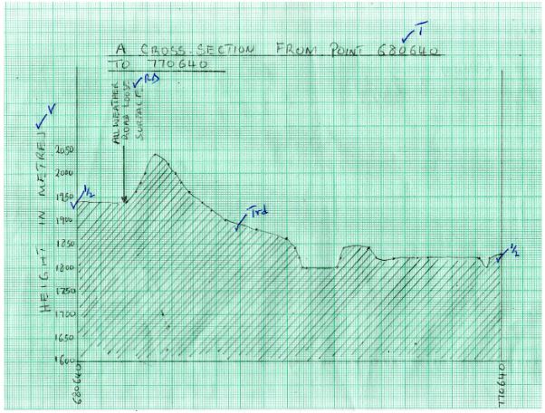
- Calculate the vertical exaggeration of the cross section (2mks)
- VE=VS÷HS
VE=1/5000 ÷1/50000
=1/5000X 50000/1
=50000÷5000
=10
- VE=VS÷HS
- Citing evidence from the map give 5 social services offered in NYERI TOWN. (5MKS)
- Education services evidenced by schools
- Health services evidenced by hospital
- Religious services evidenced by churches
- Rehabilitation services evidenced by prison
- Administration services evidenced by PC/DC/
- Water supply services evidenced by water tower
- Security services evidenced by police station
- Recreation services evidenced by Golf course any 5x1= 5mks
NB:NO CORRECT EVIDENCE NO MARK
-
-
-
- What is a weather station? (2mks)
- It is a place set aside for observation ,measurement and recording of elements of weather.
- State four factors considered when siting of a weather station. (4mks)
- Open place for free circulation of air
- The site should provide a wide view of the surrounding landscape and the sky
- It should be located away from tall buildings, trees and structures to ensure wind approaching the station is not obstructed
- The ground should be gently sloping/fairly level
- The site should be free from flooding
(any 4x1 mark)
- What is a weather station? (2mks)
- Explain how the following factors affect temperature
- Aspect (2mks)
- The south facing and north facing mountain slopes in temperate regions of the Northern and Southern Hemispheres respectively are warmer than the slopes facing the poles because they receive direct sun rays/solar insolation.
- Ocean currents (2mks)
- Onshore winds crossing a cold ocean current bring a cooling effect to the adjacent coastal land thus lowering the temperatures
- Onshore winds crossing a warm ocean current bring a warming effect to the adjacent coastal land thus raising the temperatures
- Altitude (2mks)
- Temperatures decrease with increase in altitude because at high altitude the atmosphere is thin thus allowing rapid escape of terrestrial radiation to space
- Aspect (2mks)
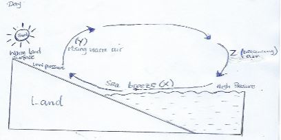
- Study the diagram below and use it to answer the questions that follow.
- State two ways through which the above phenomenon influence the climate of the adjacent land 2mks
- The sea breeze brings a cooling effect to the adjacent land lowering the temperatures of the adjacent land.
- The sea breeze raises the humidity of the adjacent land.
- The sea breeze leads to formation of convectional rainfall
- Identify areas in western Kenya where the phenomenon shown in the diagram above commonly occurs. (1mks)
- Near lakes such as around L. Victoria
- State two ways through which the above phenomenon influence the climate of the adjacent land 2mks
- With aid of a well labeled diagram, explain formation of relief rainfall. (6mks)
- A water body/sea/lake is heated causing evaporation of water
- Moist air from the sea is forced to ascend up the hill/mountain side
- As the air rises it expands which causes cooling
- The moisture /water vapor condenses to form clouds and rain mainly fall on the windward side of the hill/mountain.
- Cool dry winds descend on the leeward slopes leading to dry conditions.
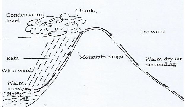
Text - 4marks
Diagram - 2mks
- Give four reasons why weather forecasting is important. (4mks)
- It enables farmers to plan their farming activities
- Helps people to determine suitable clothing for the day
- It influences designing of suitable houses
- Helps to determine air and sea travel/ guides the landing and takeoff of aircrafts
- Helps to plan for sporting activities/ military activities
- It guides fishermen in their fishing activities
-
-
-
- What is a limb in a fold? (2mks)
- Rock layers on both sides of the axis that slope in opposite directions (1X2mkS=2MKS)
- Explain how Fold Mountains are formed according to convectional current theory (3mks)
- convectional currents in the mantle are in circular motion
- the currents exerts a frictional drag with the sima rock
- this makes the crustal rocks to move horizontally which generates the compression force.
- The compression force squeeze rock materials which bend to form fold mountains.
- What is a limb in a fold? (2mks)
-
- Differentiate between orogeny and orogenesis (2mks)
- Orogeny refers to the fold mountain building period while oregenesis refers to the process of fold mountain formation
- State three factors influencing folding of sedimentary rocks. (3mks)
- Intensity/ strength of compressional force influences the folding of sedimentary rocks. The greater the intensity the more the sedimentary rocks fold.
- Type of rock/flexibility or elasticity of the rock
- The age of the sedimentary rock
- The amount of temperature within the rocks
- Differentiate between orogeny and orogenesis (2mks)
-
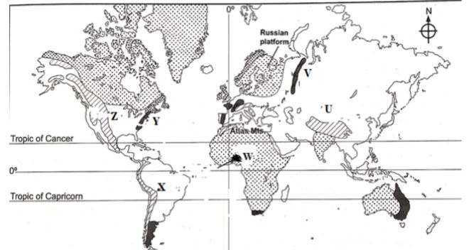
- Use the world map provided and answer the questions that follow.
Name mountain ranges marked U, V, W, X, Y and Z (6mks)- U- Himalayas
- V- Ural
- W- Akwapim Hills
- X- Andes
- Y- Appalachians
- Z- Rockies
- Draw a well labeled diagram of anticlinorium and synclinorium (3mks)
- Use the world map provided and answer the questions that follow.
- Explain three ways in which fold mountains influence climate in a region. (6mks)
- Fold mountains receive heavy rainfall on the windward slope while leeward slopes receive very little rainfall
- In the northern hemisphere the south facing slopes of fold mountains experience higher temperatures compared to the north facing slopes. In the southern hemisphere the north facing slopes have higher temperature than the south facing slopes.
- Temperature inversion occurs in the lowland valleys therefore they are cooler than the higher slopes of fold mountains
- Some fold mountains have very high attitude resulting in very low temperatures and are permanently covered with snow
Any 3x 2mks = 6
-
-
-
- Name two types of submerged highland coasts. (2 marks)
- Longitudinal / Dalmatian coast
- Ria
- Fiord / / Fjord
- Identify two resultant features of the emerged highland coasts. (2 marks)
- Raised geos / blow holes
- Raised cliffs Raised wave cut-platforms
- Raised beaches
- Raised caves
- Raised notches
- Raised archs / stumps / stack
- Name two types of submerged highland coasts. (2 marks)
- State three factors influencing deposition by ocean waves. (3 marks)
- The existence of gentle sloping shore.
- Presence of shallow water along the coastline.
- The occurrence of a strong swash and weak backwash / constructive waves.
- The existence of indented coastline.
- Ample longshore drift materials to be deposited.
- Describe the formation of the following coastal features:
- Fringing reef (5 marks)
- It is formed when coral polyps start building a reef near the shore extending seawards.
- The rate of accumulation is faster seawards than towards the shore.
- The reef therefore becomes steeper seaward than towards the shore, enclosing a narrow and shallow lagoon.
- The accumulated coral materials form a fringing reef.
- Spit (5 marks)
- It forms on a shallow shore at a point where the coastline bends landward
- Deposition occurs as the longshore drift is halted.
- More materials / deposits are piled up forming an elongated low lying ridge growing towards the sea.
- The elongated low lying ridge with one end attached to the coast and the other projecting into the sea is the spit.
- Fringing reef (5 marks)
- Explain the significance of oceans to human activities. (8 marks)
- Oceans provides building materials.
- Oceans modify the climate of the adjacent lands thus enhancing agricultural activities.
- Oceans are used by water vessels thereby enhancing transport/ communication.
- Oceans provide sites for recreational activities thus promoting tourism.
- Oceans are habitats for aquatic life hence providing food/ income to humans.
- Oceans habour minerals which are extracted for economic development.
- Ocean waves/ tides are harnessed which generate electric power for industrial/ domestic use.
- Oceans provide water for cooling industrial plants.
- Oceans encourage education and research.
- Ocean provides ideal grounds for testing military weapons. ANY 4 X 2 = 8MKS
-
-
- Differentiate between an ice berg and an ice sheet. (2mks)
- An ice berg is a large block of ice broken from ice sheets and floating in the sea or ocean while an ice sheet is a continous mass of ice which covers a very large area in the lowland, of high altitude areas.
1x 2 = 2 mks.
- An ice berg is a large block of ice broken from ice sheets and floating in the sea or ocean while an ice sheet is a continous mass of ice which covers a very large area in the lowland, of high altitude areas.
- Identify Four ways through which ice moves 4mks
- Plastic flowage / intergranular movement
- Internal shearing
- Basal slip
- Extrusion flow. 4 x 1 = 4 mks
- Differentiate between an ice berg and an ice sheet. (2mks)
- Describe the following processes of glacial erosion.
- Plucking (4mks)
- Pressure of overlying mass of ice cause freeze thaw action at the bottom.
- Melt water enters the cracks and joint on the bed rock.
- As the water freezes it exerts pressure in the cracks enlarging them.
- enlargement of cracks leads to disintegration of the rocks.
- The broken rocks are then embedded or frozen into the ice.
- As the ice moves it tears out the frozen rocks from the parent rocks a process called plucking.
Any 4 x 1 = 4 mks.
- Abrasion
- Rocks materials frozen in the moving ice are dragged over the rocky floor and on the rocky sides of the gracial valley.
- The rocks grind and scratch the rocks on the floor and the sides of the gravel valley.
- The rocks grind and scratch the rocks on the floor and the sides of the valley.
- This wears and polishes the rocks on the valley bottom and valley sides in a process known as abrasion. Any 3 x 1 = 3mks.
- Plucking (4mks)
- Describe how a glacial trough is formed. (5mks)
- Initially there is a main river valley and several tributary river valleys.
- Once glaciations occurs, ice collects and moves in both the main valley and in the tributary valleys.
- Moving ices erodes the valley through abrasion and plucking processes.
- As the tributary valleys join the main valley the amount in the main valley increases.
- The main valley becomes deeper and wider resulting in a U-shaped, steep sided valley called a glacial trough.
Any 5 x 1 = 5mks
- Students of Gitugi secondary school carried out a field study on glaciation on Mt. Kenya.
- Give three reasons why they conducted a reconnaissance (3mks)
- To enable them draw study objectives and hypothesis
- To assess the suitability of the area of study
- To enable them draw a route map
- To enable them prepare a work schedule or plan of activities
- To seek permission from the relevant authorities in the site of study.
- To enable them prepare financial requirements
- To identify the problems likely to be encountered during the study
Any first 3×1=3mks
- Give three activities they may have been involved in during the study. (3mks)
- Observing
- Taking photographs
- Counting
- Drawing sketches
- Climbing mountain
Any First 3 x 1 = 3mks
- Formulate one hypothesis that would have been relevant for study. (1mk)
- Most of the glacial features on mount Kenya are as a result of erosion.
- Most of the features on Mt.Kenya attract tourists. Any First 1 x 1 = 1mk.
- Give three reasons why they conducted a reconnaissance (3mks)
Join our whatsapp group for latest updates
Tap Here to Download for 50/-
Get on WhatsApp for 50/-
Download Geography Paper 1 Questions and Answers - Mathioya Mock Exams 2022.
Tap Here to Download for 50/-
Get on WhatsApp for 50/-
Why download?
- ✔ To read offline at any time.
- ✔ To Print at your convenience
- ✔ Share Easily with Friends / Students