
GEOGRAPHY
PAPER 1
INSTRUCTIONS TO CANDIDATES
- Answer all questions in section A.
- In section B, Answer question 6 and any other two questions from the remaining questions. ✔ Answer all questions using the answer booklet provided.

Questions
SECTION A
Answer all questions in this section
-
- What is geography? (2marks)
- Give three proofs that the earth is almost spherical in shape. (3marks)
-
- Differentiate between weathering and mass wasting. (2 marks)
- State three causes of landslides. (3 marks)
- Describe the formation of planet earth according to the passing star theory.(5 marks)
- The diagram below shows a coastal landform.
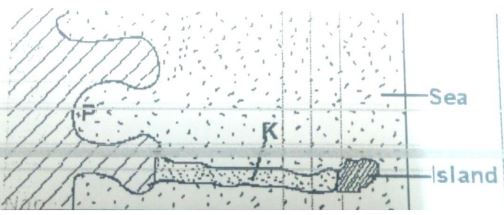
- Name the features marked P and K. (2marks) P…………………………………………………………………………………………………… K……………………………………………………………………………………………………
- List down three types of ocean tides. (3marks)
-
- Name the types of earth movements that occur within the earth’s crust. (2marks)
- Describe the origin of continents according to the theory of continental drift. (3marks)
SECTION B
Answer question 6 and any other two questions in this section
- Study the map of Kijabe 1:50,000 (sheet 134/3) provided and answer the following questions.
-
- What type of map is KIJABE map extract? (1 marks)
- Give the six-figure grid reference of the cattle dip near Kenton. (2 marks)
- Give the longitudinal extent of the area covered by the map. (2 marks)
-
- Calculate the area to the south of the power line. Give your answer in square kilometers. (2marks)
- Describe settlement distribution in the area covered by the map. (6 marks)
- Explain three factors favoring cattle rearing in the area covered by the map. (6 marks)
-
- Draw a square 10cm by 10 cm to represent the area enclosed by
Eastings 30 and 40 and northings 90 and 00. (1 marks) - On it mark and label: (3 marks)
- A railway line.
- Bamboo forest.
- A borehole.
- What is the new scale of the square. (2marks)
- Draw a square 10cm by 10 cm to represent the area enclosed by
-
-
- Name two instruments kept in a Stevenson screen. (2 marks)
- The diagram below shows a weather measuring instrument. Use it to answer the questions below.
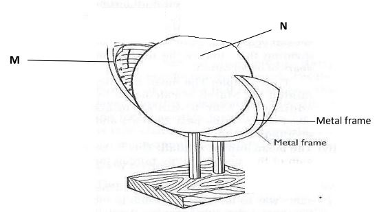
- Name the parts marked M and N. (2 marks)
M
N - Describe how the instrument works. (4 marks)
- Name the parts marked M and N. (2 marks)
- The table below shows climatic figure for station Q. Use it to answer the questions that follow.
Months J F M A M J J A S O N D Temp in ºC 30 31 31 29 27 27 28 29 28 28 27 30 Rainfall in mm 257 246 231 234 207 201 218 227 234 240 235 230 - Calculate the annual range of temperature for station Q. (2 marks)
- Give four characteristics of climate for station Q. (4 marks)
- With the aid of a well-labelled diagram, describe the formation of cyclonic rainfall. (6 marks)
- You intend to carry out a field study of a weather station in your school.
- Give two methods of recording data that you are likely to use. (2 marks)
- State three reasons why the recording of data at a school weather station may be inaccurate. (3 marks)
-
- Name three types of faults: (3 marks)
-
- With the aid of well labeled diagrams explain how compressional forces can lead to the formation of a rift valley. (7 marks)
- Give two examples of Horst Mountains in east Africa: (2 marks)
- Describe two ways in which faulting may influence drainage systems. (4 marks)
- A part from the Rift Valley name two other relief features that were formed as result of faulting. (3 marks)
- Explain three ways in which features resulting from faulting are of economic importance: (6 marks)
-
-
- What is a lake? (2marks)
- Name three ways through which lakes are formed. (3marks)
- List three sources of Lake Water. (3marks)
- Describe how L. Victoria was formed. (4marks)
- Explain two reasons why some Lakes in the Rift Valley have fresh water. (4marks)
- State three economic significance of Lakes. (3marks)
- Students from your school intends to carry out a field study on Lakes.
- State two objective for their study. (2marks)
- Identify two methods they will use to record the data collected. 2marks)
- Which human activity might they have found to be affecting the Lakes? (2marks)
-
-
- Describe plucking as a process in glacial erosion. (4 marks)
- Explain three conditions that lead to glacial deposition. (6 marks)
- The diagram below shows features resulting from glacial deposition in a lowland area.
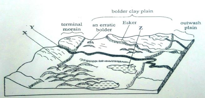
- Name the features marked X, Y, and Z. (3 marks)
- Describe how terminal moraine is formed. (4 Marks)
- Explain four positive effects of glaciation in low land area. (8 marks)
Marking Scheme
-
- What is Geography? (2 Mks)
- Geography is the study of the distribution and interrelationships of natural and human phenomena in relation to the earth’s surface/It is the study of the earth as a home of human kind.
- Geography is the study of the distribution and interrelationships of natural and human phenomena in relation to the earth’s surface/It is the study of the earth as a home of human kind.
- Give three proofs that the earth is almost spherical in shape. (3 Mks)
- Circumnavigation of the earth. When one sails or flies along a straight path without changing direction, he or she comes back to the starting point.
- The earth’s horizon appears spherical when observed from a high point.
- Rising and setting of the sun, since people living in the east see the sun earlier than those in the west.
- When a ship is approaching the land from the sea, an observer standing on a high cliff first sees the smoke, then the mast and finally the rest of the ship’s body.
- During the eclipse of the moon, (lunar eclipse), a spherical shadow of the earth is cast on the moon.
- All other planets are spherical, hence the Earth being a planet, is not an exception. Photographs of the earth taken from the space by satellites show that the earth has a spherical shape.
- What is Geography? (2 Mks)
-
- Differentiate between weathering and mass wasting. (2 marks)
- Weathering is the breakdown/disintegration/decomposition of rocks at or near surface of the earth in situ by physical/chemical processes while mass wasting is displacement/movement of weathered materials down a slope under the influence of gravity.
- Weathering is the breakdown/disintegration/decomposition of rocks at or near surface of the earth in situ by physical/chemical processes while mass wasting is displacement/movement of weathered materials down a slope under the influence of gravity.
- State three causes of landslides. (3 marks)
- The gradient of the slope.
- Nature of the materials on the slope.
- The amount of precipitation.
- Occurrence of earth movements such as earthquakes.
- Rise in temperature in glaciated highlands.
- Clearing of vegetation cover on the steep slopes.
- Human activities on steep slopes such as mining and construction.
- Differentiate between weathering and mass wasting. (2 marks)
- Describe the formation of planet earth according to passing star theory. (5 marks)
- A star with greater gravitational force passed near the sun.
- The star pulled large volume of gaseous materials from the sun.
- The materials exploded and split into portions which cooled and condensed to form planets. The gravitational force of the sun set planets on their orbits.
- The smaller gaseous materials formed smaller heavenly bodies such as planetoids natural satellites and comets, all of which revolves around the sun.
- Planet earth is one of those planets that were formed in this process.
- The diagram below shows a coastal landform.
- Name the features marked P and K. (2 Mks)
- P – Bay
- K – Tombolo
- List down three types of ocean tides. (3 Mks) Perigian tides.
- Apogean tides.
- Spring tides.
- Neap tides.
- Name the features marked P and K. (2 Mks)
-
- Name the types of earth movements that occur within the earth’s crust.(2 Mks)
- Horizontal earth movement Vertical earth movement
- Horizontal earth movement Vertical earth movement
- Describe the origin of continents according to the theory of continental drift. (3 Mks) There was initially one super continent/Landmass known as Pangaea.
- It was surrounded by large water mass known as panthalassa.
- Later Pangaea broke into two continents namely Laurasia (Northern continent) and Gondwanaland (Southern continent).
- The two were separated by a narrow ocean called Tethys.
- Laurasia split into the current Northern continents: North America, Europe and Asia, while Gondwanaland split to the current Southern continents: Africa, South America, India, Australia, New Zealand and Antarctica.
- Name the types of earth movements that occur within the earth’s crust.(2 Mks)
-
-
- What type of map is KIJABE map extract? (1 marks)
- A topographical map.
- A topographical map.
- Give the six figure grid reference of the cattle dip near Kenton. (2 marks)
- 279014
- 279014
- Give the longitudinal extent of the map. (2 marks)
- From 36030’E to 36045’E
- From 36030’E to 36045’E
- What type of map is KIJABE map extract? (1 marks)
-
- Calculate the area to the south of the power line. Give your answer in km2. (2 marks)
- Full squares: 16
- Half squares: 28
- Total: 16+14= 30km2(± 0.5km2)
- Describe settlement distribution in the area covered by the map. (5 marks)
- There are no settlement within the Ewaso Kedong valley
- There are nucleated settlement in the markets/shopping centres/villages
- Some areas with steep slopes /ridges /river valleys have fewer /no settlement
- There are fewer settlement within the forest
- Kinale/Kinari forest station has dense settlement
- There are no settlement within the plantations
- There are few settlements to the west of Naivasha-Narok road
- The area covered by the map is generally sparsely settled
- There are linear settlement along some roads in the area covered by the map
- Calculate the area to the south of the power line. Give your answer in km2. (2 marks)
- Explain three factors favoring cattle rearing in the area covered by the map. (6 marks)
- The presence of scrub and scattered trees show that there is natural pasture for cattle
- The presence of many rivers/sources of water show that there is adequate water for cattle
- The area has high altitude/above 1000m which provide cool conditions suitable for cattle rearing
- The many cattle dips for treatment show that there is access to veterinary services
- There are large tracts of land with few settlements ensuring extensive areas available for grazing
- Availability of transport as shown by roads/railway for movement of cattle/cattle products
- Dense settlement to provide market for cattle/cattle products
-
- Draw a square 10cm by 10 cm to represent the area enclosed by Eastings 30 and 40 and northings 90 and 00. (2 marks) (5 marks)
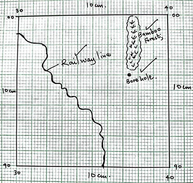
- A railway line.
- A bamboo forest.
- A borehole.
- New scale.
(Reduction 2 marks, features 3 marks, new scale 2 marks).
- Draw a square 10cm by 10 cm to represent the area enclosed by Eastings 30 and 40 and northings 90 and 00. (2 marks) (5 marks)
-
-
- Name two instruments kept in a Stevenson screen. (2 marks)
- Hygrometer
- Maximum thermometer
- Minimum thermometer
- The six’s thermometer
- The diagram below shows a weather measuring instrument. Use it to answer the questions below.
- Name the parts marked M and N. (2 marks)
- M - Sensitized card
- N - Cylindrical glass lens
- Describe how the instrument works. (4 marks)
- The glass sphere focusses the sun’s rays on a sensitized card which is graduated in hours and minutes.
- The heat burns the paper/card as the sun moves across the sky.
- The unburnt sections in the card indicates when there was cloud cover.
- At the end of the day, the card is removed and the number of hours that the sun shined are obtained by adding the burnt sections on the card.
- Name the parts marked M and N. (2 marks)
- The table below shows climatic figure for station Q. Use it to answer the questions that follow.
- Calculate the annual range of temperature for station Q. (2 marks)
- =31-27= 4ºC
- =31-27= 4ºC
- Outline four characteristics of climate in station Q. (4 marks)
- The station experiences high temperatures.
- Highest temperature is 310C/the lowest temperature is 270C.
- The annual range of temperature is 40C/the station has a low range of temperature. The station experiences high rainfall/2760mm.
- The station experiences rainfall throughout the year/there is no dry month. Lowest rainfall is experienced in May and July when temperature is also lowest. The station has one rainfall maxima.
- Calculate the annual range of temperature for station Q. (2 marks)
- With the aid of a well-labelled diagram, describe the formation of cyclonic rainfall. (6 marks)
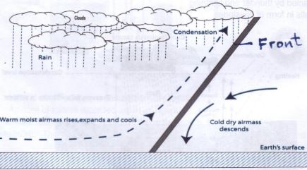
Text – 4 marks
Diagram – 2 marks
TOTAL (6 marks)- It occurs along the temperature front.
- It is the meeting point of cold, heavy dry polar easterlies and warm, light and moist north/south westerlies.
- The meeting of the air masses forms a front.
- When the two air masses meet along the front, the warm lighter westerly, winds rises over the cold polar air.
- Since it is moist, the air condenses forming clouds.
- The clouds become heavy enough, eventually falling as rain through the cold air. This is cyclonic/frontal rainfall.
- You intend to carry out a field study of a weather station in your school.
- Give two methods of recording data that you are likely to use.(2 marks)
- Filling in questionnaires
- Labelling of samples
- Note taking
- Taking photographs
- Sketching diagrams
- Tabulation
- State three reasons why the recording of data at a school weather station may be inaccurate. (3 marks)
- Human error.
- Interference with the instruments by animals and people.
- Poor siting of a weather station.
- Extreme weather conditions.
- Natural calamities i.e. landslides.
- Use of defective instruments.
- Give two methods of recording data that you are likely to use.(2 marks)
- Name two instruments kept in a Stevenson screen. (2 marks)
-
- Three types of faults:
- Normal
- Reverse/ thrust/ low angle over thrust
- Tear / shear / transform
- Continual fault
-
- How compressional forces can lead to the formation of a rift valley Diagram
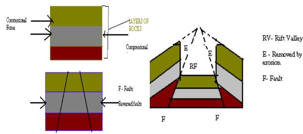
- Layers of rocks are subjected to compressional forces
- Two parallel faults develop
- Outer blocks are thrust upwards
- Middle block sinks / remains at a lower level
- The protruding parts are eroded by erosion / collapse
- Diagram = 3 marks Explanation 4 x 1 = 4
- Two examples of Horst Mountains in east Africa:
- Pare
- Usambara
- Ruwenzori
Any 2 x 1 = 2 marks
-
- If rift faulting occurs in an enclosed area, a basin may be formed. When rivers flow into the basin, a lake may be formed. This basin may become an area of inland drainage.
- Some rivers may end up flowing along fault lines, thus forming a fault-guided drainage pattern.
- Uplifting of land which follows faulting may block a river. This may cause it to reverse or change its direction of flow.
- When faulting occurs across a river valley, it may cause the river to disappear into the ground through a fault line.
- When faulting occurs across a river valley, vertical displacement of land may occur. The river forms a waterfall where it descends the newly formed escarpment. Faulting may lead to the formation of escarpments with springs forming at the base due to exposure of the water table.
-
- tilt block
- escarpment / scrap slope
- block mountain / horsts
- fault steps
- How compressional forces can lead to the formation of a rift valley Diagram
- Ways in which features resulting from faulting are of economic importance:
- Blocks / horst mountains are a source of rivers which provide water for industrial/ agricultural / domestic use / HEP production.
- Rift valley formation has led to exposure of minerals such as diatomites/ soda ash which are mined on the rift valley floor.
- Mountains formed through faulting attract rain which favour agriculture activities / settlements Rift valley lakes are important fishing grounds/provide water for irrigation / transportation. Faulted features provide scenery which promotes tourist industry.
Any 3 x 2 = 4 marks
- Three types of faults:
-
-
-
- A lake is a mass of water which occupies a basin, depression or a wide hollow on the earth’s surface. (1 x 2 = 2mks)
- A lake is a mass of water which occupies a basin, depression or a wide hollow on the earth’s surface. (1 x 2 = 2mks)
-
- Earth movement
- Vulcanicity
- Erosion
- Deposition
- Meteorites.
- Human activities
- By mass movement (any 3x1 = 3mks)
-
- Rainwater
- Rivers
- Underground water
- Melting ice (any 3x1 = 3mks)
-
-
- Lake Victoria was formed as a result of earth movement (down warping) which resulted into formation of a basin like depression.
- The level to the west and south was uplifted therefore making the rivers flowing westward to start flowing eastward to back tilting.
- The reversal of the drainage caused river water to flood their valleys and fill the depression to form a lake.
-
- They have surface outlets / rivers through which excess salt deposits are carried away. Some have underground outlets which drains the salts that would have accumulated at the bed.
- Some experience low rates of evaporation because they are located in low temperature areas.
- The lakes have regular inlets of fresh water which dilutes the salts.
-
- Some of the lakes are located in areas of high rainfall which keeps the water fresh. (first two correct 2 x 2 = 4mks)
- Some lakes provide water for domestic and industrial use.
- Some lakes provide water for irrigation.
- Some lakes are sources of minerals e.g. Turkana and L. Magadi.
- Lake shores are sources of sand which is used in the construction industry. Some lakes are used to generate HEP.
- Some lakes are used for transport.
- Lakes attract tourists.
- Some lakes are used for fishing. (first 3 correct x 1 = 3mks)
- NB: Mark any relevant as regards to the lakes e.g.
-
-
- To find out the importance of lakes.
- To find out problems affecting lakes.
- To find out the sources of water in the lake. (2 x1 = 2mks)
-
- Drawing sketches
- Note taking
- Tape recording
- Taking photographs. (any 2x1 = 2mks)
-
- Agriculture - excessive irrigation reduces the volume of the lake. Chemicals used in the farms pollute the water.
- Industrialization: disposal of industrial wastes pollutes the lake water.
- Deforestation – may cause the lake to be silted.
- Introduction of weeds. (any first 2x1 = 2mks)
-
-
-
- Describe plucking as a process of glacial erosion. (4 Mks)
- Pressure from the overlying mass of ice causes freeze thaw action.
- Melting water fills the cracks/joints in the bed rock.
- As water freezes it exerts pressure on the cracks enlarging them.
- The enlarged cracks lead to disintegration of the rock.
- The rock debris are scoured or pulled off the mother rock by the moving ice. The disintegrated rocks eventually get embedded within the mass of ice. As the ice moves, it pulls out or gorges out the embedded rock from the mother rock.
- This process is called plucking.
- Explain three conditions that lead to glacial deposition. (6 Mks)
- Rising temperature lead to melting of ice thereby causing the ice to deposit its load. Change of gradient to relatively flat surface will reduce the velocity of the glacial movement which will subsequently lead to deposition of glacial materials.
- Alternating warm and cold periods lead to seasonal melting of ice which allows materials embedded in the ice to be released and deposited.
- Stagnation/accumulation of glaciers leads to pressure at the base of the glacier which in turn leads to melting of ice at the base. The melt water then carries and deposits materials underneath which loosens the heavy materials beneath the mass ice and is subsequently deposited. Friction at the base and sides of a glacier and a rough surface leads to melting of ice, causing the ice to deposit its load.
- The diagram below shows features resulting from glacial deposition on a lowland area.
- Name the features marked X, Y and Z. (3 Mks)
X - Drumlins
Y – A river/melt water
Z – kettle lake/lake - Describe how terminal moraine is formed. (4 Mks)
- Moving ice carries solid materials
- Moving ice stagnates and ice at the snout melts.
- Melting ice releases its load
- Gradually the load piles into a ridge
- Over time the ridge forms a horse shoe shape/block of solid materials called terminal moraine
- Name the features marked X, Y and Z. (3 Mks)
- Explain four positive effects of glaciations in lowland areas. (8 Mks)
- Glacial till provides fertile soils which are suitable for arable farming.
- Ice sheets in their scouring effect may expose the minerals making them easy to extract. Out wash plains comprise of sand and gravel which are used as building/construction materials.
- Glacial lakes found in lowland areas can be exploited for various economic uses such as fishing and transportation.
- Glaciation forms features such as drumlins, eskers which are tourists attraction hence foreign exchange earnings.
- Glaciated lowlands are generally flat and ideal for establishment of settlements/development of transportation network.
- Describe plucking as a process of glacial erosion. (4 Mks)
Join our whatsapp group for latest updates
Tap Here to Download for 50/-
Get on WhatsApp for 50/-
Download Geography Paper 1 Questions and Answers - Royal Exam Series Post Mock Trial Exams 2022.
Tap Here to Download for 50/-
Get on WhatsApp for 50/-
Why download?
- ✔ To read offline at any time.
- ✔ To Print at your convenience
- ✔ Share Easily with Friends / Students


