
SECTION A
Answer ALL the questions in this section.
-
- Give three reasons why it is necessary to study the plate tectonics theory. (3 marks)
- Name two types of tectonic plate boundaries. (2 marks)
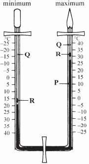
- The diagram below shows a Six’s thermometer. Name the parts marked P,Q and R. (3 marks)
- The table below shows temperature readings at a weather station for one week.
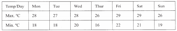
Calculate the following.- The diurnal range of temperature for Tuesday; (1 mark)
- The mean temperature for Saturday. (1 mark)
- The diagram below shows a Six’s thermometer. Name the parts marked P,Q and R. (3 marks)
- Give two examples of non-metalic minerals. (2 marks)
- Why is industrial diamond used in shaping hard stones and diamond? (1 mark)
- Apart from vapour, name two other substances that are suspended in the atmosphere. (2 marks)
- Give two factors that are considered when classifying clouds. (2 marks)
- Name two types of clouds that give rise to rainfall in the tropical reasons. (2 marks)
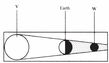
- The diagram below shows an eclipse. Name the features marked V and W. (2 marks)
- State four proofs that the shape of the earth is spherical. (4 marks)
SECTION B
Answer question 6 and any other TWO questions from this section.
- The diagram below shows an eclipse. Name the features marked V and W. (2 marks)
- Study the map of Kericho 1:50,000 provided and answer the following questions.
- Give the longitudinal extent of the area covered by the map. (1 mark)
- Convert the scale of the map into a statement scale. (2 marks)
- What is the approximate height of the hill in the grid square 6770? (2 marks)
- Calculate the area of Kericho Municipality. Give your answer in square kilometers. (2 marks)
- Give three types of natural vegetation found to the west of Easting 53. (3 marks
- What is the bearing of the trigonometrical station at grid reference 554668 from the factory at grid reference 610626? (2 marks)
- Identify three forms of land transport found in the north of Northing 68 and west of Easting 53. (3 marks)
- Describe the distribution of settlements in the area covered by the map. (4 marks)
- Citing evidence from the map, explain three factors that favour the establishment of tea estates in the area covered by the map. (6 marks)
- Differentiate between magma and lava. (2 marks)
- The diagram below shows some intrusive volcanic features.
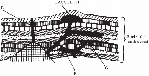
Name the features marked E, F and G. (3 marks) - Describe how the following features are formed and for each give an example from Kenya.
- a crater; (3 marks)
- a geyser; (5 marks)
- a lava plateau. (4 marks)
- Explain four ways in which volcanic features influence human activities. (8 marks)
- Name two sources of rivers. (2 marks)
- The diagram below shows the three stages of the long profile of a river.
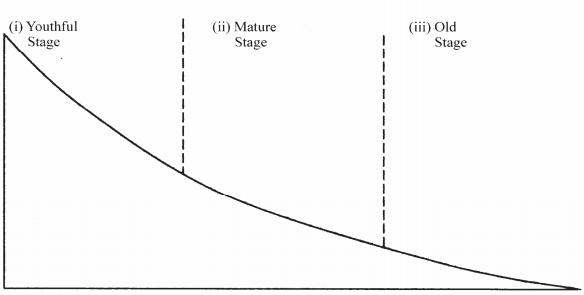
Give two features formed by rivers in each of the three stages. (6 marks)
- Describe the process by which a river transports its load. (6 marks)
- Describe the following drainage patterns:
- Dendritic pattern; (3 marks)
- Trellis pattern; (3 marks)
- You are required to carry out a field study on the materials deposited by a river.
- State two methods you would use to collect data. (2 marks)
- State three advantages of studying the work of rivers through fieldwork. (3 marks)
- Describe how ice is formed on a high mountain. (3 marks)
- Apart from a valley glacier, name two types of ice masses found on Mountains in East Africa. (2 marks)
- Explain how the following movement of a valley glacier is influenced by the following factors:
- Temperature; (2 marks)
- Width of a glacier channel. (2 marks)
- Describe the distinctive characteristics of the following features resulting from glacial erosion:
- A corrie; (3 marks)
- A pyramidal peak; (3 marks)
- A friod (fjord). (3 marks)
- The diagram below shows a glaciated upland area. (3 marks)
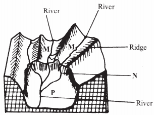
Name the features marked M, N and P. (3 marks) - Describe the process through which a crag and tail is formed. (4 marks)
- The diagram below shows a glaciated upland area. (3 marks)
-
- The diagram below shows a breaking sea wave.
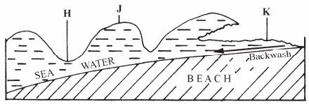
- Name the parts labeled H, J and K. (3 marks)
- What is a backwash? (2 marks)
- Describe three processes of wave erosion along the coast. (6 marks)
- Explain how the following factors influence wave deposition;
- Gradient of the shore; (4 marks)
- Depth of the sea. (3 marks)
- Using well labeled diagrams, describe how a bay is formed. (6 marks)
- The diagram below shows a breaking sea wave.
Join our whatsapp group for latest updates
Tap Here to Download for 50/-
Get on WhatsApp for 50/-
Download Kenya Certificate Of Secondary Education (KCSE 2008) Geography Paper 1.
Tap Here to Download for 50/-
Get on WhatsApp for 50/-
Why download?
- ✔ To read offline at any time.
- ✔ To Print at your convenience
- ✔ Share Easily with Friends / Students


