
Section A
Answer all questions in this section
-
- Name two methods of underground mining (2 marks)
- State three factors that influence mining (3 marks)
-
- Define the following terms:
- Forest
- Agro-forestry
- State three benefits of agro- forestry in Kenya (3 marks)
- Define the following terms:
-
- Identify three means by which we can move on water (3 marks)
- State two problems facing communication in Kenya (2 marks)
-
- What is external trade? (2 marks)
- State three reasons why Kenya trades in raw materials rather than finished products (3 marks)
-
- Name two settlement patterns (2 marks)
- State three physical factors that influence settlement (3 marks)
SECTION B
Answer question 6 and any other two questions in this section
- The table below shows the Value of export crops from Kenya in the year 1995.
CROP/YEAR
1995
Maize
224,000,000
Coffee
168,000,000
Tea
320,000,000
Horticultural
190,000,000
Total
902,000,000
Use it to answer the questions below.-
- Draw a divided rectangle measuring 15cm to represent the above data (9 marks)
- State three advantages of using divided rectangles to represent geographical data (3 marks)
- state four physical conditions that favor coffee growing in Kenya Highlands (4 marks
- describe the processing of coffee from harvesting to marketing (6 marks)
- list three ways in which planted coffee is taken care of by the farmers (3 marks)
-
-
-
- Name two types of fishing grounds in Kenya (2 marks)
- Give two types of fish (2 marks)
- Give four reasons why marine fishing Industry in East Africa is not well developed (4 marks)
- Explain four ways in which marine fisheries are being conserved in Kenya (8 marks)
- Use the map of North America below to answer question (i) and (ii)
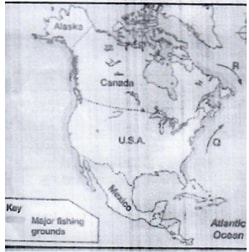
- Name one method of fishing used in the shaded area
- Name ocean currents marked Q and R.
- Explain why major fishing grounds of the world are located in the temperate latitudes of the northern hemisphere.
- State three items you would include in your schedule.
-
-
- Distinguish between manufacturing and tertiary industries.
-
- Name four agricultural food processing industries in Kenya. (4 marks)
- Explain four factors that influenced the location of the iron and steel industries in The Ruhr region of Germany. (8 mrks)
- Give five reasons why the government of Kenya encourages the establishment of Jua Kali industries. (5 mrks)
- You intend to carry out a field study in a coffee factory near your school.
- State three reasons why you would visit the area of study in advance. (3 mrks)
- You have prepared a working schedule for your study.
-
-
- Differentiate tourism from eco- tourism (2 marks)
- Give four tourist attractions found in Nairobi County (4 marks)
-
- Explain four human factors which influence the development of tourism in Kenya
- State five problems facing tourism in Kenya (5marks)
- Give six reasons why domestic tourism should be encouraged in Kenya (6marks)
-
-
-
- Apart from petroleum, name three non- renewable sources of energ (3marks)
- Name an area in Kenya where petroleum is mined (1 mark)
- Explain five effects of over relying on petroleum on the Kenyan economy (10m arks)
- Give five reasons why it is difficult for the Kenyangovernment to fully exploit its Geothermalpower (5marks)
- Identify six methods that Kenya can use to conserve its energy (6marks)
-

MARKING SCHEME
SECTION A
-
- -The jig-saw fit of continental margins
-Paleo climates which show evidence of glaciation where there is no continental ice today
- Mid-Atlantic ridges formed after continents separated
- Same geological structure of work some rocks in different continents have the same kind of structure (2x1) (2mks) - Extension boundary- separate two plates that move away from each other.
Compression boundary – separates two plates that move towards each other.
Shear/ Transform boundary – where two plates move past each other in opposite direction (3x1)(3mks)
- -The jig-saw fit of continental margins
-
- Orbit refers to the path in space followed by a planet as it revolves around the sun while axis is an imaginary line through the center of the earth on whose pivot the planet’s rotate (2x1) (2mks)
- -Volcanic eruption
-holes drilled increase with the depth of the mines
-Percolating underground water comes out as hot springs (3x1)3mks)
-
- – By suspension
-By saltation
-By surface creep/rolling /traction (2x1(2mks) - – presence of loose unconsolidated dry masses of mud, sand and gravel that is easily acted upon by wind
-occurrence of strong tropical wind storms within the hot deserts
- Absence of vegetation cover which exposes the land to erosion (3x1)(3mks)
- – By suspension
-
- Dew point is the temperature at which the air cools and becomes saturated with moisture (2x1) (2mks)
- –Difference in air pressure
- Distance from the sea
- Presence or absence of a barrier e.g. mountain (3x1)( 3mks)
-
- –valley glaciers
-Ice caps
- Cirque glaciers (2x1) (2mks) - - It has steep sides
-It is surrounded by cirques
-Has a sharp rock/ has a sharp horn
-Has radiating system of aretes (3x1)( 3mks)
SECTION B
- –valley glaciers
-
-
- 354143(2mks)
- –west pokot
-Elgeyomarakwet
-Trans Nzoia (3x1) 3mks
-
- – central part of the map has nucleated settlements
- The forest has no settlements
- There are nucleated settlements in the plantations south of northing 18
- There are no settlements within the swamps
- South of kitpaberr forest has clustered settlements (4x1) 4mks - – Gentle relief evidenced by spaced contours allows mechanization
-Permanent Rivers allows for irrigation
-Numerous rivers of the forest show the area receives high rainfall
- Well spaced settlements create more space for farming
- Forest and woodland suggest the areas has deep soils for agriculture
- Dense settlements indicate adequate market and labor to work on the farms
- Scrub vegetation provides pasture for pastoralism.(5x1) 5mks
- – central part of the map has nucleated settlements
-
- Gradient of point Mand N
G=VI
HD
1920-1840
9,200
80
9200= 0.0087(2MKS) - Highest point is 2362m (2mks)
- Gradient of point Mand N
-
- - Get exact location of the area
- Identify suitable mode of transport to use
- Get to know the extent of the area to be covered
- prepare a work schedule
- Decide on suitable data collection technique (2x1) 2mks - –observation
-interviewing
- taking measurements (2x1) 2mks - – type of crops grown/animals kept
-management principles
- Market for their products
- Problems experienced /solutions
- Mode of transport for their produce (3x1) 3mks
- - Get exact location of the area
-
-
-
- x- desert
y- Modified tropical climate - Has low minimal temperature
-Has a small diurnal range of the temperature
- It has a small annual temperature of between 200c-230c
- receives moderate to high rainfall
- Rainfall ranges between 750mm-1500mm per year with no distinct dry months/rains throughout the year.
- Relative humidity is about 80%
- The area receives convectional type of rainfall and falls mainly in the afternoon accompanied by thunder and lightning.
- Has double rainfall maxima
- Experiences low pressure
- There is thick cloud cover.
- x- desert
-
- Altitude
- Temperature decrease with increasing height above sea level with 0.60C for every 100m of ascend because the air is denser at lower altitudes and rare up the altitudes.
- Atmospheric pressure is higher at lower altitudes and lower at higher altitudes.
- The temperature is higher at low altitudes and lower at high altitude because the air is heated from below and not directly from the sun statements (2mks)
Explanation (2mks) - Ocean currents
-onshore winds blowing over warm ocean currents are warmed and absorb more watervaporcausing a warming effect on adjacent land resulting into increased rainfall and high humidity. Onshore winds blowing over cold ocean currents are cooled and moisture condenses resulting to low rainfall in the air and a cooling effect on adjacent land leading to desertification, little rainfall/fog or mist.
2 Marks x 2 (4mks)
- Altitude
- Negative effects of climate change on physical environment
-Disruption of ecosystem /loss of biodiversity /abnormal growth of plants caused by the increasing ultra-violet radiation.
-flooding of coastal land caused by increased temperature which leads to melting of glaciers thereby causing arise in the sea level( change in rainfall pattern /change in seasonal pattern
- Increased temperature may lead to drying up of water reservoirs thereby reducing their lifespan.
-Drought caused by increased temperature may lead to drying up of water reservoirs thereby reducing their lifespan.
- Drought caused by increased temperature may lead to high evaporation /change in the rainfall pattern (seasons pattern)
- Increase in rainfall leads to flooding /rise in sea level /soil erosion
-Soil erosion by wind caused by change in wind /air mass pattern.
- High ocean /sea waves /storms due to change in wind (air mass pattern when they blow more frequently and are more destructive such as cyclones. (6mks) -
- – It is a wooden box
- It is raised/ placed on a stand about 121cm above the ground level.
- It is painted white
- It has a double roof
- The sides are covered to allow free circulation of air.(3x1) 3mks - – Types of weather recording instruments
-Statistical data/tables/diagrams/maps on previous weather records
- Diagrams / photographs on instruments
- Information on weather forecasting
-information on operations of weather and measuring instruments.(3x1) 3mks
- – It is a wooden box
-
-
-
- –longitudinal/Dalmatian
-ria
- fiord(2x1) 2mks - -raised geos
-raised cliffs
-raised wave cut platforms
-raised beaches
-raised cave
-raised notches
-raised arches(2x1) 2mks
- –longitudinal/Dalmatian
- –The existence of gently sloping shores
- Presence of shallow water along the coastlines
- Ample long shore drift materials to be deposited(3x1) 3mks -
- -Fringing reef coral polyps start building a reef near the shore extending seawards
- The rate of accumulation is faster Seawards than towards the shore
- The reef therefore becomes steeper seawards than towards the shore enclosing narrow and shallow lagoon
-The accumulated coral materials form a fringing reef(5mks) - spit
-It forms on shallow shore at a point where thecoastlinesbends towards the land Deposition occurs as the long shore drift is halted
-more materials are deposited and pile up a farming an elongated low lying ridge with one end attached to the coast and the other projecting into the sea known as (5mks)
- -Fringing reef coral polyps start building a reef near the shore extending seawards
- – Oceans modify the climate of the adjacent lands thus enhancing agricultural activities
- oceans are used by water vessels thereby enhancing transport
- oceans provide sites for recreational activities thus promoting tourism
- oceans are habitat for aquatic life hence providing food
- oceans habour minerals which are extracted for economic development.
- oceans waves are harnessed which generate electric power for industrial are domestic use.
-oceans provide water for cooling industrial plants
- oceans provides ideal site for testing military weapons(4x2)8mks
-
-
- – pressure from overlaying mass of ice cause freezing
-melting waters fills the cracks / joints in the bed rock
-As water freezes, it exerts pressure on the cracks enlarging them
-The enlarged cracks lead to disintegration of the rock
-The disintegrated rock eventually get embedded within the mass of ice.
-As the ice moves ,it pull/gives out the embedded rocks from the parent rock
NB: last point must be mentioned to score four (4 marks) - -rising temperature lead to melting of ice thereby causing ice deposits its load
-Change of gradient to relatively flat surface will reduce the velocity of the glacial movement which will subsequently lead to deposition of fluvial glacial materials
-Alternatively warm and cold periods lead to seasonal melting of ice which allows materials embedded in the ice to be released and deposited
-Obstruction /stagnation/accumulate of glacier leads to pressure at the base of the glacier which in turn leads to melting of ice at the base causing embedded materials to be released and deposited
-melt water carries and deposits materials underneath which loosens heavy materials beneath the mass of ice -
- cirque, areta,pyramidalpeak, glacial trough , hanging valley ,truncated spurs(3 x 2) 6mks
- –moving ice carries solid materials
-moving ice stagnates
-ice at snout melts
- Gradually the load piles into a ridge
- overtime the ridge forms a horseshoe shaped /block of solid materials called terminal moraine(4x1) 4mks
- – some glacial till provides fertile soils which are suitable for arable farming
-ice sheets in their scouring effects reduce the surface which may expose the materials making them easy to extract
- Some out wash plains comprise of sand and gravel which are used as building materials
- glacial lakes found in low land areas can be exploited for various economic use such as fishing /transportation
-glaciation formsfeatures such as drumlins eskers which are tourist attractions thus earning country foreign exchange
- Glaciatal lowlands are generally flat and ideal for establishment of settlements and development of transportation network (4x2) 8mks
- – pressure from overlaying mass of ice cause freezing
-
-
- Factors influencing vegetation distribution
- Rainfall
-Areas with high rainfall have dense vegetation .areas with low rainfall have sparse vegetation
-Temperatures
Areas with very high temperatures such as desert areas have sparse vegetation. Areaswith coolto warm conditions have dense vegetation
Altitude
At very high altitude there’s sparse vegetation
terrain and drainage of land
Areas that are gently sloping have dense vegetation
Soil
Highands with volcanic and loamy soils support dense growth of vegetation (4x2) 8mks - –forest vegetation
-savanna vegetation
-Arid and semi-arid vegetation
-Health and moorland vegetation
-swamp vegetation (2x1) 2mks
- Factors influencing vegetation distribution
-
- – They have closely set trees with distinct layers or canopies
- Thick canopy cut out sunlight hence there’s little undergrowth.
- Tree trunks are commonly buttressed at the base
- Epiphytes are supported by big trunks of the tall trees (3x2) 6mks - – Trees occur in mixed species
-Tree trunks are big and heavy to transport
- Forest are very thick hence accessing the trees to exploit difficult
-Heavy rainfall in the areas making it swampy hence difficult in movement (2x1) 2mks
- – They have closely set trees with distinct layers or canopies
-
- – sources of herbal medicine
-sources of timber for construction
-it’s a source of raw materials for industries e.g. paper
- act as wind breakers - - To investigate the uses of mountain vegetation
-To find out the tree species found in mountain forests
- To find out importance of mountain forests
- To investigate the measure taken to conserve and manage the forest. - –photographing
-tape recording
-note taking
- field sketching
-Tallying(2x1) 2mks
- – sources of herbal medicine
-
Join our whatsapp group for latest updates
Tap Here to Download for 50/-
Get on WhatsApp for 50/-
Download GEOGRAPHY PAPER 2 - KCSE 2019 MARANDA MOCK EXAMINATION.
Tap Here to Download for 50/-
Get on WhatsApp for 50/-
Why download?
- ✔ To read offline at any time.
- ✔ To Print at your convenience
- ✔ Share Easily with Friends / Students


