
SECTION A:
Answer all questions from this section.
-
- What is a line of longitude? (2mks)
- What is the time at Moyale on 380E when the time at Tema on prime meridian (00) is 1.00p.m? (3mks)
-
- Name two theories of the origin of the Earth. (2mks)
- Identify three layers of the earth’s atmosphere. (3mks)
-
- Name the scale used to measure the magnitude of an earthquake. (1mk)
- List three causes of earthquakes. (3mks)
-
- State three factors influencing the development of Karst scenery. (3mks)
- Give three surface features formed in limestone areas. (3mks)
-
- Distinguish between block disintegration and exfoliation (2mks)
- State three economic benefits of weathering (3mks)
SECTION:B
Answer question 6 and any other two in this section.
- Study the map of Taita (1:50000) sheet 189/4 provided and answer the questions that follow.
-
- Show the longitudinal extent of the area covered by the map. (1mk)
- Convert the scale of the map to a statement scale. (2mks)
- Calculate the area of the forest at Majengo and Shelemba between eastings 35 and 40 and below northing 21.(2mks)
- Draw a square 12cm by 12 cm to represent the area enclosed by Easting 40 and 43 and the Northing 27 and 30. On the rectangle mark and name the following features. (1mk)
- All weather road loose surface D535 (1mk)
- Water pipeline (1mk)
- River (1Mk)
- Forest (1mk)
-
- Citing evidence from the map give three types of economic activities carried out in the area covered by the map. (3mks)
- Name two natural features that indicate that the area covered by the map receives high rainfall. (2mks)
- Name three social activities taking place within wundanyi town. (3mks)
-
- Citing evidence from the map, explain three Factors that have influenced distribution of settlements in the area covered by the map. (6mks)
- Give the magnetic variation of the area when the map extract was drawn. (1mk)
-
-
-
- Identify two processes through which wind erodes the earth’s surface. (2mks)
- Name two major deserts found in Africa. (2mks)
- The diagram below represents a barchan. Use it to answer b(i)
- Name the feature marked
J
K (2mks) - Describe how the following features found in hot desert are formed.
An oasis (5mks)
A yardang (5mks)
- Name the feature marked
- You are supposed to carry out a field study of a semi-arid area in Kenya.
- State three ways through which you would prepare yourself for the field study. (3mks)
- What information would you collect through observation that would indicate that the area is turning into a desert? (3mks)
- State three measures you would recommend to be put in place to control desertification in the area. (3mks)
-
-
-
- What is a waterfall? 2mks
- Give two economic significance of a waterfall. 2mks
- Identify two drainage patterns along the slope of a mountain. 2mks
-
- Describe the following river erosion processes
Hydraulic action 4mks
Solution 2mks
- Describe the following river erosion processes
-
- Apart from deltas, outline four characteristics of a flood plain. 4mks
- State three factors that favour the formation of delta. 3mks
- Describe the formation of an arcuate delta and give an example. 4mks
-
- State any two negative effects of rivers. 2mks
- What is a coast. 2mks
-
-
- Explain two ways in which the nature of rocks influences the shape of coast. 4mks
- Outline three characteristics of a fiorded coast. 3mks
- Describe the formation of oceanic islands. 4mks
-
- State four causes of ocean currents. 4mks
- Explain four ways Kenya benefits from coastal landforms. 8mks
-
-
- What is an iceberg? 2mks
- State three factors which determine the speed of a glacier. 3mks
-
- Other than a Pyramidal Peak, name three features on a glaciated highland. 3mks
- Describe the formation of a Pyramidal Peak. 5mks
- With the aid of a well labeled diagram, describe the formation of a Crag and tail. 4mks
- Explain two ways in which glaciation in highlands is of economic benefits to human beings. 4mks
- Your class carried out a field study on a glaciated lowland.
- State two reasons why you needed a route map. 2mks
- Identify two problems you were likely to face during your study. 2mks
-

MARKING SCHEME
SECTION. A.
-
- What is a line of longitude? (2mks)
It is a line based on the angular distance of a place east or west of the prime meridian(00) / it is an imaginary line which is drawn on a map from North pole and south pole and is measured in degrees east or west of the prime meridian. (00) - What is the time at Moyale on 380 E when the time at Tema on prime meridian (00) is 1.00p.m? (3mks)
Moyale is ahead by 380.
10 = 4 minutes
38 x 4 = 152 hours.
60
1.00 + 2hrs 32 minutes
Moyale time will be 3.32p.m
- What is a line of longitude? (2mks)
-
- Name two theories of the origin of the Earth. (2mks)
- Passing star theory/ big bang theory.
- Nebula clouds theory.
- Collision theory.
- Supernova theory.
- Identify three layers of the earth’s atmosphere. (3mks)
- Troposphere
- Stratosphere
- Mesosphere
- Thermosphere/ionosphere
- Name two theories of the origin of the Earth. (2mks)
-
- Name the scale used to measure the magnitude of an earthquake. (1mk)
Ritcher scale. - List three causes of earthquakes. (3mks)
- Energy released within the mantle.
- Blasting of rocks/ bombs explosion.
- Construction of large water reservoir.
- Folding / faulting .
- Isostatic adjustment.
- Movement of magma within earth’s crust/ volcanicity.
- Gravitative pressure.
- Collision of tectonic plate.
- Name the scale used to measure the magnitude of an earthquake. (1mk)
-
- State three factors influencing the development of Karst scenery. (3 mks
- Surface rock and the rock below should be hard and well joined.
- Climate should be hot to speed chemical weathering and humid for availability of rain which is solvent.
- Water table to be far below the surface so that the whole limestone rock is not dissolved and underground feature fail to be form (3x1=3mks)
- Surface rock should be calcareous (limestone, Diatomite or chalk)
- Give three surface features formed in limestone areas. (3mks)
- Grike and clints
- Sink holes
- Dry valley
- Limestone gorge
- Karst bridge
- Dolines/Uvalas/Poljes (3x1=3mks)
- State three factors influencing the development of Karst scenery. (3 mks
-
- Distinguish between block disintegration and exfoliation (2mks)
Block disintegration is a process in which blocks of rocks break away from the original rock mass along joints and bending planes Exfoliation is a process through which rocks peel off resulting in the formation of curved rock shells Resulting in the formation of curved rock shells - State three economic benefits of weathering (3mks
- Weathering causes break up of parent rocks forming soils used for agriculture
- Weathering produces natural resources eg.clay used for pottery
- Weathering produces features eg granitic tows which attract tourists.
- Weathering weakens the rock mass making its easy to exploit through quarrying /mining
- Distinguish between block disintegration and exfoliation (2mks)
SECTION B.
Answer question 6 and any other two in this section.
- Study the map of Taita (1:50000) sheet 189/4 provided and answer the questions that follow.
-
- Show the longitudinal extent of the area covered by the map. (1mk)
380 18’E to 380 30’E - Convert the scale of the map to a statement scale. (2mks)
1Km = 100,000cm
1: 50000
X=50,000
1km=100,000
1cm represents 0.5km - Calculate the area of the forest at Majengo and Shelemba between eastings 35 and 40 and blow northing 21. (2mks)
Full squares = 0
Half squares = 20
Area = 20/2 = 10km2
- Show the longitudinal extent of the area covered by the map. (1mk)
- Draw a square 12cm by 12 cm to represent the area enclosed by Easting 40 and 43 and the Northing 27 and 30. On the rectangle mark and name the following features. (1mk)
All weather road loose surface D535 (1mk)
Water pipeline (1mk)
River (1Mk)
Forest (1mk)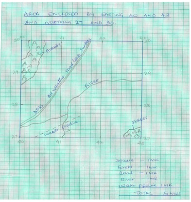
-
- Citing evidence from the map give three types of economic activities carried out in the area covered by the map. (3mks)
- Trade – Evidenced by many shops.
- Transport – evidenced by many roads e.g. all weather road C104.
- Plantation farming – evidenced by Teita Sisal estates/farmers.
- Livestock Keeping – evidenced by cattle dip on grid square 3026
- Name two natural features that indicate that the area covered by the map receives high rainfall. (2mks)
- Forest
- Permanent rivers
- Citing evidence from the map give three types of economic activities carried out in the area covered by the map. (3mks)
- Name three social activities taking place within wundanyi town. (3mks)
- Rehabilitation – prison
- Education – school
- Administration – chief’s office
- Communication – post office
- Citing evidence from the map, explain three Factors that have influenced distribution of settlements in the area covered by the map.(6 mk)
- There is linear settlement along the all weather road bound surface especially around mwatale area.
- There are no settlements within the forests but along the edges of the forest e.g mwasere forest, possibliy due to government policy gazetting some areas as forest zones.
- There are no settlements on the steep escarpment but settlements are seen just below the escarpments e.g escarpments at mwachawa, secho, mlegwa etc.
- Possible because it’s difficult to construct building on very steep slopes.
- There are also no settlements on hill tops but at the bottom of the hills e.g lower majego due to the steep ferain.
- No settlement in the sisal estates since there’s the plantation farming taking place. However, there is a nucleated settlement at Mwatunge just after the sisal estate propably for the labourers working within the farm.
- There’s scattered settlement in the S.E part of the area covered by the map possibly due to poor soils and less rainfall as indicated by the presence of scrub vegetation.
- There is also a dense settlement in the eastern side of the area covered by the map probably because of many all weather roads, schools, churches, hospitals and other social facilities provided.
- Give the magnetic of the area when the map extract was drawn 0º30´(1mk)
-
-
-
- Identify two processes through which wind erodes the earth’s surface. (2mks)
- Deflation
- Abrasion
- attrition
- Name two major deserts found in Africa. (2mks)
- Sahara
- Kalahari
- Namib
- Identify two processes through which wind erodes the earth’s surface. (2mks)
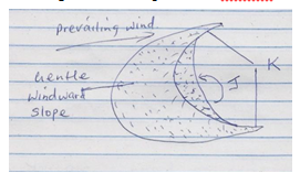
- The diagram below represents a barchans. Use it to answer b(i)
- Name the feature marked .
J Eddy current (1MK)
K Horn (1MK) - Describe how the following features found in hot desert are formed.
- An oasis (5mks)
An oasis – is formed when a preexisting depression is exposed to wind erosion. Wind eddies remove unconsolidated materials through deflation. As deflation continues, the depression is deepened and enlarged. The process of deflation is aided by weathering. With continued deflation, the level of the water table is reached. Water oozes out of the ground and collects into the depression to form an oasis. - A yardang (5mks)
A Yardang is formed in desert area where alternative vertical layers of hard and soft rocks occur. The soft rocks are eroded faster than the hard resistant rocks. Abrasion continues and the furrows on the soft rocks widen gradually leaving the hard /resistant rock forming ridges separating the furrows. The ridge is called a yardang.
- An oasis (5mks)
- Name the feature marked .
- You are supposed to carry out a field study of a semi-arid area in Kenya.
- State three ways through which you would prepare yourself for the field study. (3mks)
- Formulating hypothesis / objectives.
- Grouping / appointing group leaders.
- Planning a schedule of activities.
- Carrying out reconnaissance.
- Studying /drawing a route map.
- Identifying methods of data collection.
- Reading from relevant written materials.
- Assembling relevant tools /equipment/materials.
- Seeking permission.
- What information would you collect through observation that would indicate that the area is turning into a desert? (3mks)
- Sparse settlements.
- Stunted trees /tuff of grass.
- Sparse vegetation/large patterns of bare soil.
- Dust storms/sand storms.
- Evidence of wind erosion.
- Presence of drought resistant crops.
- State three measures you would recommend to be put in place to control desertification in the area. (3mks)
- Planting of trees .
- Controlling overgrazing.
- Avoid bush fires.
- Controlling tree cutting.
- Practicing appropriate methods of cultivation/ control faming / mulching/ irrigation.
- State three ways through which you would prepare yourself for the field study. (3mks)
-
-
-
- What is a waterfall?
A water fall is a place on a river course where a river bed is vertical or nearly vertical (2mks) - Give two economic significance of a waterfall. (2mks)
- It’s a tourist attraction
- It can be harneseed to generate electricity.
- It hinders water transport along some river courses (2 x 1=2mks)
- Identify two drainage patterns along the slope of a mountain. (2mks)
- Dentritic drainage system
- Radial drainage system (2x1=2mks)
- What is a waterfall?
-
- Describe the following river erosion processes
- Hydraulic action (4mks)
Erosion by the force of river when it thrust itself into cracks and joints of rocks on the side of the channel dislodging rock particles.
By pushing air into the cracks, compressing it increasing pressure which widens the cracks. When water retreats, air in cracks expands as pressure decreases. Repeated compression and expansion of air causes rocks to break. The broken particles are carried downstream (2x2=4mks) - Solution (2mks)
River water dissolve soluble rock minerals along the river channel. Dissolved minerals are transported in solution form dowmstream. (2x1=2mks)
- Hydraulic action (4mks)
- Describe the following river erosion processes
-
- Apart from deltas, outline four characteristics of a flood plain. (4mks)
- broad and flat or level landscape
- made of thick alluvial deposits
- some have ox-bow or raised banks.
- Presence of natural levees or raised banks
- Deferred tributaries/confluences
- Presences of meanders
- Braided channel
- Presence of swamps or marshes (4 x 1=4mks)
- State three factors that favour the formation of delta. (3mks)
- Large load such as from large catchment area where erosion is taking place actively.
- The river course to be free from obstacles.
- Low speed at the point where the river is entering a sea.
- The rate of deposition should be higher than the rate of erosion by sea or lake current. (3mks)
- Describe the formation of an arcuate delta and give an example. (4mks)
- Formed when coarse and fine sediments are deposited at the mouth of a river.
- The strong sea waves push the sediments giving a delta a convex shore line.
- Deposition at the mouth causes the river to subdivide into distributaries e.g. The distributaries subdivide too thus many distributaries River Niger, River Tana (4mks)
- Apart from deltas, outline four characteristics of a flood plain. (4mks)
- State any two negative effects of rivers. (2mks)
- Rivers flood causing loss of life and property.
- Stagnant water can be a medium of breeding of pests that transmit diseases such as bilhazia and malaria
- Some wide rivers are barriers to transport and communication. (2x1=2mks)
-
-
-
- What is a coast.
A strip of land bordering the sea /ocean. 2x1=2mks - Shape of the coast depending on rocks. (explain)
- Hard rocks resist wave erosion and give rise to highlands coasts with features little cliffs and healand,
- Soft rocks are less resistant to wave erosion leading to sea inlets e.g bays.
- Highly founded rocks will be eroded by hydraulic action producing features such as caves, stacks and stumps.
- Limestone areas are subjected to solution erosion to produce karst landscape along the coasts. 2x 2 = 4mks
- What is a coast.
- Characteristics of fiord coast
- Formed from deep glacial trough.
- Deep with very steep sides.
- Deeper landward and shallow sea wards.
- They lie below sea level.
- Have islands on the seaward side.
3 x 1 = 3mks
- Ocean islands
- Earths movements result to formation of cracks/faults on the floor of the ocean.
- Magma flow through the crack onto the ocean floor.
- Continued eruption increases magma material on the floor which rises to near sea level.
- Localized uplift of the ocean floor rises the volcanic material to be exposed.
- Exposure is further done during low tides to form islands.
4 x 1 = 4mks
-
- Causes of ocean currents
- Wind blowing over the surface of the ocean.
- Rotation of the earth .
- Shape of the land masses.
- Difference in temperatures of ocean waters. 4 x 1 = 4mks
- Benefits of coastal landforms
- Coastal features from the scenery which attract tourists who bring foreign exchange.
- Recreation e.g sports fishing
- Coral reefs are a source of raw material for cement making.
- The form transport highways .
- Lowland coasts provide good sites for development of settlement.
- Oceans provide a source of food - fish.
- Mangrove vegetation in mudflats are used for timber and fuel production.
4x 2 = 8mks
- Causes of ocean currents
-
-
-
- An iceberg
A large mass of ice which has broken off from icesheet and partially submerged in water.2 x 1 = 2mks - Speed of glacier.
- Gradient slope.
- Season – faster in summer than winter due thawing.
- Friction of the glacier – amount of friction is greater on the sides of the valleys.
- Thickness and weight of the glacier. 3 x 1 = 3mks
- An iceberg
-
- Features of glaciated highlands
- Arête
- Hanging valley
- Cirque
- Rock basin.
3x1 = 3mks
- Formation of pyramidal peak.
- Snow accumulates in cracks/ hollows of a mountain side.
- It exerts pressure on crack/ hollows.
- Plucking processes enlarge hollows and more ice collects in them.
- Freeze - thaw process enlarges the cracks, moving ice plucks off loose rocks materials from the basin thus enlarging it.
- Nivation eats into back walls of the basin making them recede into the mountain side.
- Steep sided knife edged ridges separate the basins.
* Three or more of these ridges /Aretes converge at the mountain top forming a jagged peak known as pyramidal peak.
NB: * point to be mentioned to score five marks. 5 x 1= 5mks
- Features of glaciated highlands
- Diagram explaining the formation of a crag and tail.
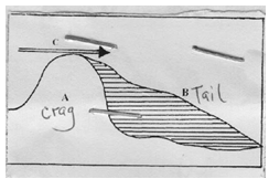
Formed when hard resistant rock lies in the path of the moving ice, rock experiences a lot of glacial erosion/ abrasion on the upstream windward side forming the crag while the leeward side downstream experiences deposition forming the tail.
diagram 2mks explanation 2 = 4 mks - Two ways in which glaciations of highlands is an economic benefits to man.
- Hanging valleys forms water falls.
- Essential for the formation of HEP.
- Site for winter games e.g skiing
- Catchment for rivers.
- Fords are natural habours for commercial activities.
- Highlands features attract tourists – foreign exchange.
Any 2 well explained points 2 x 2 = 4mks
-
- Field study route map.
- Identify the direction to face.
- Help find features.
- Help estimate distance
- Estimate time to be taken. 2 x = 2mks
- Two problems to face in the study.
- Rough terrain
- Accidents like falling rocks
- Getting lost in the area
- Attach/fear of wild animals
2 x 2 = 2mks
- Field study route map.
-
Join our whatsapp group for latest updates
Tap Here to Download for 50/-
Get on WhatsApp for 50/-
Download GEOGRAPHY PAPER 1 - 2019 KCSE CEKENA MOCK EXAMINATION (QUESTIONS AND ANSWERS).
Tap Here to Download for 50/-
Get on WhatsApp for 50/-
Why download?
- ✔ To read offline at any time.
- ✔ To Print at your convenience
- ✔ Share Easily with Friends / Students


