
INSTRUCTIONS TO STUDENTS
- This paper has two sections: A and B.
- Answer all the questions in section A.
- Answer question6 and any other two questions from section B.
- Candidates should check the question paper to ascertain that all the pages are printed as indicated and that no question is missing
SECTION A ( 25 MARKS )
ANSWER ALL QUESTION IN THS SECTION
-
- What is nomadic pastoralism? (2mks)
- State any three characteristics of nomadic pastoralism (3mks)
-
- Name two oil producing countries in Africa (2mks)
- State three effects of land dereliction due to mining (3mks)
-
- Differentiate horticulture and market gardening (2mks)
- List three characteristics of horticulture (3mks)
-
- Name two countries in Kenya where wheat is grown on large scale (2mks)
- Give three physical conditions that favour large scale wheat farming in the prairies provinces of Canada (3mks)
-
- Define the term agroforestry (2mks)
- State three reasons why agro forestry is encouraged in Kenya (3mks)
SECTION B
Answer question six and any other two questions from this section
-
- The table below shows the types of forest in Kenya in hectares
closed forest
900ha
Woodland
300ha
Grassland
200ha
bamboo
60ha
mangrove
40ha
Total
1500ha
- Draw a divided rectangle 10 cm long to represent the above information (7mks)
- Give three advantages of using divided rectangles to represent data (3mks)
-
- A part from coniferous forest name two other types of natural forest (2mks)
- State five characteristics of coniferous forest (5mks)
- Explain four factors which favour the growth of natural forest in the highlands of Kenya (8mks)
- The table below shows the types of forest in Kenya in hectares
-
- Name three crops grown in Kenya to produce vegetable oil (3mks)
- Give three uses of palm oil (3mks)
-
- Name the main type of coffee grown in Kenya (1mk)
- State five physical conditions favouring coffee growing in Kenya highlands (5mks)
- Describe the stages of coffee production from picking to marketing (10mks)
- A geography class carried out a field work in coffee factory near.their school state three ways in which they prepared for the field study (3mks)
- Use the map of North America below to answer questions (a)
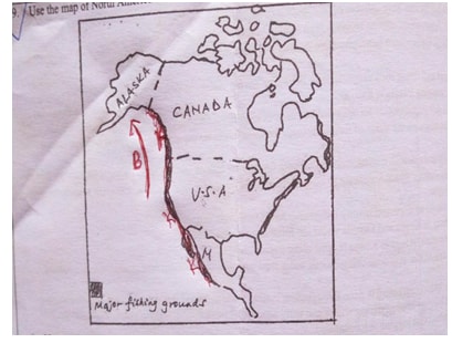
- Name
- The fishing ground marked K (1mk)
- The ocean current marked (B) (1mk)
- Explain physical conditions necessary for fishing in the fishing ground shaded.(8mks)
- Describe trawling method of fishing (6mks)
-
- Explain three ways in which overfishing can be controlled in lake Naivasha (6mks)
- State three significance of fish farming (3mks)
- Name
-
- Name two methods of irrigation practiced in mwea irrigation scheme (2mks)
- Explain three significance of irrigation farming in Kenya (6mks)
- Describe the stages involved in land reclamation in the Netherlands through the Zuider Zee project (10mks)
-
- State the similarities between land reclamation in Kenya and the Netherlands (4mks)
- A Geography class in Mwea high school carried out a field study in Mwea irrigation scheme about irrigation farming state three follow-up activities they would be involved in (3mks)
-
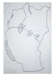
- Name the national parks marked P,Q,R (3mks)
-
- Give reasons why game researves and national parks are located in the marginal areas. (3mks)
- A part from wild life name three other tourist attraction in the western Kenya circuit (3mks)
- State four ways in which tourist attractions in Kenya differ from those of Switzerland (4mks)
- Explain how the following factors influence the distribution of wildlife in Kenya
- Vegetation (2mks)
- Altitude (2mk)
- Explain four measures that Kenya should take in order to attract more tourist (8mks)
- Name the national parks marked P,Q,R (3mks)

MARKING SCHEME
-
- Whats nomadic pastoralism
refers to extensive grazing of livestock on natural pasture grass involving constant or seasonal migration of nomads and their livestock in search of water and pasture 1x2=2mks - characteristics of nomadic pastoralism
- involves seasonal migration of the nomads and their livestock in search of water or pastures
- large herd of animals are kept
- wide variety of animals are kept
- nomads normally rely on natural vegetation for their pasture
- nomads live simple life styles in temporary building
- land tenure is normally communal
3x1=3mks
- Whats nomadic pastoralism
-
- Oil produce countries in Africa
- Nigeria
- Egypt
- Niger
- Algeria
- Sudan
- morocco
- Libya
- south sudan
- Angola
- Tunisia
2x1mks
- Effects of land dereliction due to mining on the environment
- Waste of agricultural land
- waste of industrial land
- ugliness/loss of aesthetic (beauty)
- health and accidental hazards 3x1=3mks
- Oil produce countries in Africa
-
- Differentiate horticulture and market gardening
Horticulture is the intensive cultivation of vegetables, fruits and flowers for export market while market gardening is the intensive cultivation of vegetables and fruits for sale in the nearest urban centre 1x2=2mks - Characteristics of horticultural farming
- The activity is scientifically oriented as advanced methods of crop production are used
- its capital intensive for purchase of fertilizers/pesticides and labour.
- mainly practiced near urban centres
- it involves use of quick and expensive modern modes of transport like air
- its export oriented 3x1=3mks
- Differentiate horticulture and market gardening
-
- Name two coutries in Kenya where wheat is grown on large scale
- uasin gishu
- narok
- nyandarua
- meru
- nakuru 2x1=2mks
- Physical conditions which favour wheat growing in Canada (3mks)
- Extensive land
- fertile prairie soils
- undulating landscape
- warm summer/frost free
- moderate rainfall
- Name two coutries in Kenya where wheat is grown on large scale
-
- Define agro forestry
It is a land use system where there is growing of trees and crops on the same piece of land at the same time 1x2=2mks - Reasons why agro forestry is encouraged in Kenya
- To ensure continuous supply of wood fuel timbers herbal medicine and raw materials for paper making
- Reduce importation of forest products
- create employment opportunities
- protect the soil from erosion
- improve scenic beauty
- to maintain hydrological cycle
3x1=3mks
SECTION B
- Define agro forestry
-
-
- closed forest=900 x10cm=6cm ½mk
1500
woodland= 300 x10=2cm ½mk
1500
Grassland= 200 x10 =1.33 cm ½mk
1500
Bamboo =60 x 10=0.4 cm ½mk
1500
mangrove 40 x10=0.27cm ½mk
1500
A DIVIDED RECTANGLE REPRESENTING TYPES OF FORESTS IN KENYA IN HECTARES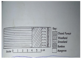
Rectangle –(1mk)
Title- (1mk)
Calculation –(2½ mks)
segments-(2½mks) NB: Not drawn to scale - Advantages of divided rectangle (3mks)
- its easy to draw /construct
- it gives clear visual impression of individual components
- it can be used for comparison purposes.
- it can be used to represent a wide range of data
- closed forest=900 x10cm=6cm ½mk
-
- Types of natural forests (2mks)
- tropical rainforest
- mangrove forest
- temperate deciduos forest
- evergreen forest
- monaoon forest
- Mediterranean forest 2x1=2mks
- Characteristics of coniferous forest (5mks)
- The trees are found in pure strands hence easy to exploit
- Most of trees have straight trunks/tall trees
- trees are ever green
- light trees hence easy to cut and transport
- trees take long time to mature
- the trees are conical dhaped
- trees have thick barks
- trees have hard needle-shaped leaves to reduce the rate of evaporation. 5x1=5mks
- Factors which favour growth of natural forest in the highlands of Kenya(8mks)
- The area receives high rainfall (over 1000m-1500mm) per year which encourages the growth of trees
- the area has deep/well drained volcanic soils that allow roots to penetrate deep into the ground
- The area has moderate to high temperature about 14-20ºc that allow growth of variety of trees.
- The area is a gazette forest hence settlement/cultivation is prohibited.
- some areas are steep/rugged hence discourages settlement and allow for forest growth.
- enforcement of laws to allow re-establishment of forest 4x2=8mks
- Types of natural forests (2mks)
-
-
- Crops grown in Kenya to produce vegetable oil (3mks)
- maize/corn
- sunflower
- groundnuts/peanuts
- cashew nuts
- sim sim
- coconuts
- cotton
- soya beans
- macadamia
- Give three uses of palm oil (3mks)
- Used domestically for cooking. lighting and polishing
- used in the manufacture of cooking fats,soaps,candles etc
- kernels is used to make expensive cooking oil,margarine,cosmetics and oil soaps
- used as a cleaning agent in industries
-
- Name the main type of coffee grown in Kenya
Arabica (1mk) - State five physical conditions favouring coffee growing in the highlands (5mks)
- Temperature ranging from 14ºc-26ºc
- Rainfall high-1000-2030mm p.a
- Well distributed rainfall throughout the year
- Gently sloping landscape (1500m-2300m above sea level)
- Deep well drained soils
- Volcanic soils
- Describe the stages of coffee production from picking to marketing(10mks)
- The ripe/deep red berries are picked by hand
- The harvested berries are carried in baskets/sacks to the factory
- at the factory, the berries are sorted out to remove the unripe and diseased berries
- The different grades are then weighed
- berries go through a machine that removes the out covering /pulp
- the beans are fermented in tank for some times
- the beans are washed and then sun dried for about a week
- the husks are removed and the beans winnowed .
- the beans are sorted out and graded according to the size and quality
- the beans are roasted at temp of about 10ºc
- the beans are grounded into powder ready for sale
NB: sequence must be followed.
- Name the main type of coffee grown in Kenya
- A geography class carried out a field work in a coffee factory near their school. State three ways in which they prepared in this study (3mks)
- divide themselves into groups
- they would formulate objectives and hypothesis for the study
- they would conduct a pre-survey reconnaissance to the area of study
- prepare a working schedule
- they seek for permission from relevant authorities
- Crops grown in Kenya to produce vegetable oil (3mks)
-
-
- Fishing ground K -N.E pacific fishing ground (1mk)
- Current B-Warm North pacific current (1mk)
-
- the availability of cool climatic condition of about 20ºc favours the variety of fish species favours which is fish food
- The warm north pacific current that washes the coastline raises the low temperatures resulting in waters that are ideal for the health growth of plankton and ice free allowing fishing to be carried out throughout the year.
- The indented-coastline with several fords and river estuaries as well as sheltered inlets from good sites from fish ports and fish breeding respectively.
- The presence several rivers and lakes that form suitable fishing grounds fro species such as salmon
- The rugged mountainous landscape,dense forest cover in British Columbia and rocky surfaces discourages agricultural activities.this has forced many people to take up fishing as a source of food
- The presence of excellent fishing ports,such as prince report,west port makes it easier to access foreign markets (2x4 =8mks)
- A bag shaped net is attached to a trawler/ship
- the nets mouth is kept open by other boards
- the upper part of mouth of nets has floats and weight at the bottom;to keep part of the net at the sea bed
- each end of the net is attached to a boat
- the net is cast to the water and the trawler drags the net along the sea bed
- after sufficient fish has been caught the net is hauled to the trawler to empty the fish (6mks)
-
- Restrictions enforced on the type size of nets that should be used to avoid indiscriminate fishing
- by restocking,releasing fingeshings to increase generation of fish
- a selected number of fishermen can be licensed to carry out fishing to allow breeding and maturity of fish
- establishing fish farms with popular species of fish such as tilapia to ease pressure on fishing in the lake
(3x2)=6mks
- Fish farms provide fish for both subsistence and commercial use
- fish from fish farms is used to restock overfished grounds
- establishing and fishing in fish farms provide employment opportunities
- the development of fish farms complements the fish being caught from natural water (3mks)
- Restrictions enforced on the type size of nets that should be used to avoid indiscriminate fishing
-
-
- Basin irrigation
furrow irrigation (2mks) - Significance of irrigation farming in Kenya
- Farmers earn income from scales of produce, hence improving their living standards
- many people are employed in the farms and other in transportation of produce earning income improving their living standards
- created settlement for thousands of people who would have been landless
- has led to reclamation of unproductive land thus increasing farm land and curbing desertification
- has led to reclamation of unproductive land thus increasing farm land and curbing desertification
- exportation of some crops generate foreign exchange which is then invested in other sectors of the economy 2x3=(6mks)
- Improvement of roads enable cheap transportation of inputs and produce to and out of the schemes/opening up areas for development
- Has led to growth of industries since some crops are source of raw materials to these industries.
- has led to the development of better socal amenities like schools,hospitals leading to improved living standards of the people
- Has increased food production in the country making to beself reliant in terms of food
- Stages involved in land reclamation in Netherlands
- Construction of protective dykes to enclose part of the sea
- construction of ring canals to carry water from the reclaimed area into the sea.
- Installation of pumping stations to pump out water from the enclosed area
- reeds were planted to absorb excess salt
- drainage ditches were cut into the land and pipes were laid to drain excess salts
- division of the area into rectangular portions using inner dykes and ring canals
- treatment of soils with chemicals to lower salinity
- drained land was flashed with flesh water to remove excess salt from the soil
- continuous pumping of water from the polder to prevent accumulation in the reclaimed land (10mks) sequence to be followed)
-
- Similarities between land reclamation in Kenya and the Netherlands
- in both cases the reclaimed land was used fro crop farming and settlement
- in both countries dykes are used to drain any water from the reclaimed land
- in both coutries canals and ditches are used to drained water from the reclaimed land
- in both countries government assist in the work of land reclaimed land
- in both countries fertilizers are used to improve soil fertility
- Follow up activities they would be involved in
- reading more about irrigation farming
- displaying photographs
- asking and answering questions
- report writing
- discussion with the rest of class
- assessing the information collected against the hypothesis
(3mks)
- Similarities between land reclamation in Kenya and the Netherlands
- Basin irrigation
-
-
- p-Ruwenzori 1mk
- Q-Serengeti (1mk)
- R-tsavo (1mk)
-
- Reasons why National park and game reserves allocated in marginal areas.
- Human population in marginal areas is low and thus reduce threat of animals interfering with human life and crop destruction
- it is the best economic use of land since agriculture doesn’t do well in such areas
- it requires extensive land that is only available in those areas
- other tourist attraction in the western Kenya circuit (3mks)
- Other tourist attraction in the western Kenya circuit a part from wild life
- kit mikai granite
- lake Victoria
- rusinga and mfangano island (3x1)=3mks)
- Ways in which tourist attractions in Kenya differ from those of Switzerland.
- Kenyan culture is more diverse than Switzerland
- Kenya had wide coastal beaches where areas Switzerland beaches are used seasonally
- Kenya has game parks where areas Switzerland has graciated valleys
- Kenya has not sunny climate all year round while Switzerland has not summer and cold winters (4mks)
- Reasons why National park and game reserves allocated in marginal areas.
-
- Vegetation
Different plants and animals are found in forested area zones such as forested areas,grasslands vegetations desert vegetation. (2mks) - Altitude
The different climate and vegetation type in different heights determine the type of animals and plants presents in an area (2mks)
- Vegetation
- Measures Kenya should take inorder to attract more tourist
- improving infrastructure/roads/airports/communications to all tourist sites in order to make them easily accessible
- Improving security to ensure safety of the tourist is guaranteed
- marketing the county more aggressively in order to make it more known/improve the image of the country abroad
- establishing a diversity of tourist attraction to avoid depending entirely on the traditions attractions and reduce competition with other tourist destinations
- Establishing/modernizing tourist facilities in areas that have high potential such as western Kenya where facilities are in adequate.
- Intensify domestic marketing to reduce reliance on foreign tourist(2x4)=8mks
-
Join our whatsapp group for latest updates
Tap Here to Download for 50/-
Get on WhatsApp for 50/-
Download GEOGRAPHY PAPER 2 - 2019 KCSE CEKENA MOCK EXAMINATION (QUESTIONS AND ANSWERS).
Tap Here to Download for 50/-
Get on WhatsApp for 50/-
Why download?
- ✔ To read offline at any time.
- ✔ To Print at your convenience
- ✔ Share Easily with Friends / Students


